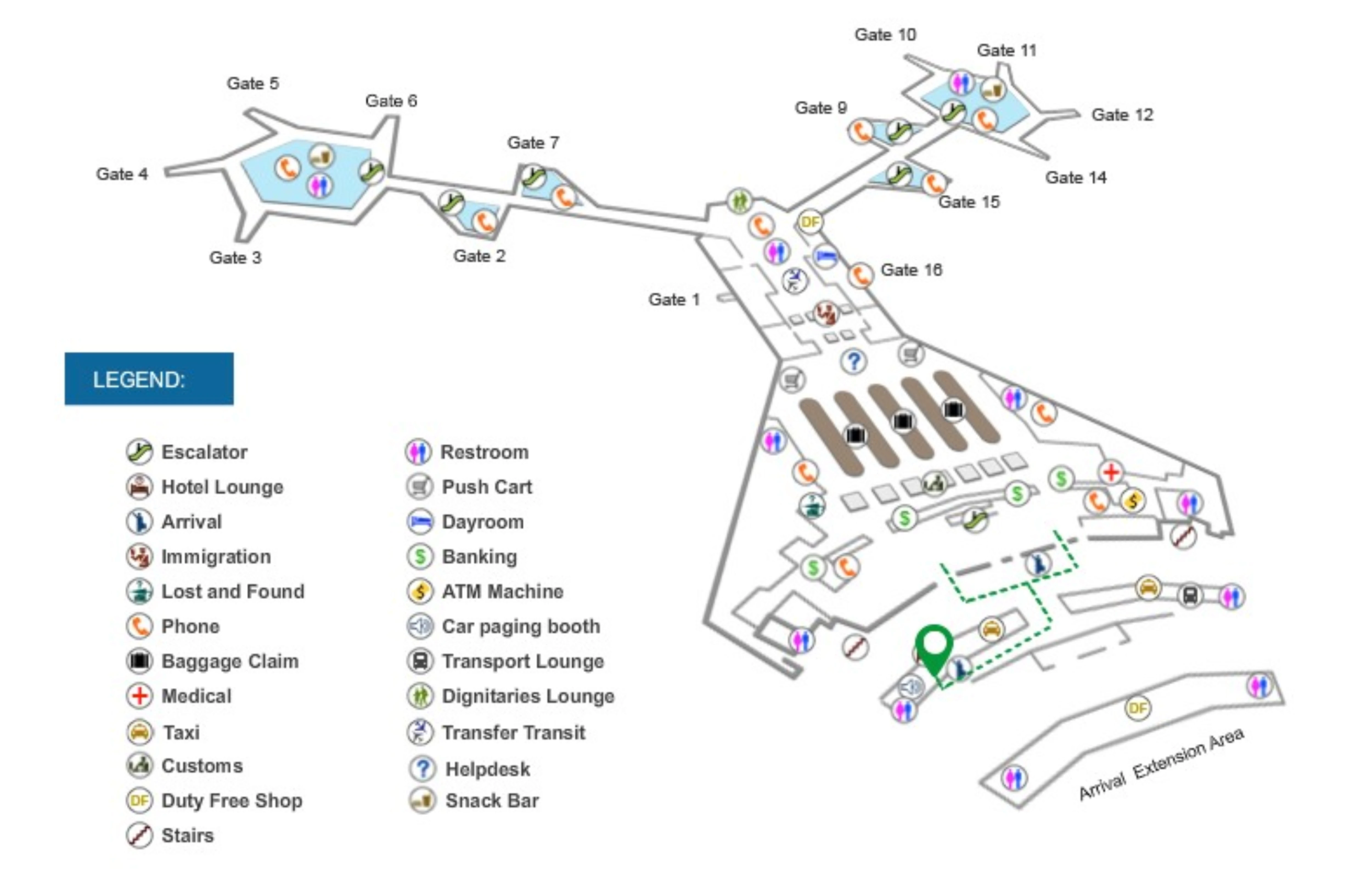
Ninoy Aquino International Airport Terminal 1 Map (Most Up-To-Date)
NAIA Terminal 1 is a rigid “head house + Y-shaped concourse arms” layout: a central processing block feeding East and West airside corridors, with Arrivals/ground transport stretched along a long, linear curb. Within Manila’s main airport complex, flow converges at a single immigration funnel and then disperses into three curbside zones (A/B/C). Scale-wise, expect long curbside walks (hundreds of meters) and short interior walks (tens of meters) once inside the check-in hall.
Map Table
| Zone | Connection | Walk Time |
|---|---|---|
| Arrivals curb Zone A (A1–A14) | private pickup, hotel bays | central exits ↔ A14+; 3–5 min |
| Arrivals curb Zone B (B1–B6) | Grab ride-hail island | cross service road; ~1 min |
| Arrivals Extension Zone C | yellow/coupon taxis | past A14+; long walk |
| Departures Check-In Hall | check-in, travel tax, baggage wrap | security to counters; ~10–15 m |
Ninoy Aquino International Airport Terminal 1 Map Strategy
- Treat Arrivals transport as a three-zone decision: Zone A for private/hotel bays, Zone B (B1–B6) for legitimate Grab pickup on the outer island, Zone C for metered/coupon taxis farther down the extension.
- Model the shuttle as an “A14+ endpoint” walk: from typical Arrivals exits near A6/A7, commit to a rightward curb walk (about 250–300 m) past A10, A11–A12, and A13–A14; no shortcut from the middle bays.
- Assume immigration has one funnel: the tail forms at the ground-level escalator base, and in heavy surges the overflow can reverse up the escalators into the upper arrivals corridor; no bypass path around the merge.
- Sequence departures checkpoints to avoid re-screening friction: curbside door security first, then immediate check-in rows inside; once you enter the Check-In Hall, no internal path to the public dining wings without exiting and re-clearing security.
2026 Ninoy Aquino International Airport Terminal 1 Map + Printable PDF
Current operations still reflect the post–Jan 2025 arrivals curb setup: Bays A1–A14 handle most curbside activity, while the inter-terminal shuttle loads beyond Bay A14 at the Arrival Extension edge. Wayfinding remains weakest right after Customs (transport choices split across A/B/C) and during peak immigration waves when queues back up toward the escalators and into the upper corridor.
2026 Ninoy Aquino International Airport Terminal 1 Map Guide
What is the exact landside pickup point for the inter-terminal shuttle at NAIA Terminal 1, relative to the Arrivals exit doors?
The inter-terminal shuttle pickup is beyond Bay A14 on the main Arrivals curb, at the far right end of the frontage. From the Arrivals exit doors, go outside to Zone A and turn right along the covered curb past Bays A1–A10, then past A11–A12 and the hotel cluster at A13–A14; the shuttle loads at the transition into the open-air Arrival Extension where MIAA bus signage appears.
Shuttle traffic shares the same inner curb lane as private pickups, so there is no mid-curb loading point near the central exit doors (commonly around A6/A7). If you are standing under the busiest private-pickup segment (A1–A10), the correct move is still to keep walking right until the covered curb ends and the frontage starts to curve toward the parking/exit road.
What is the walking distance (meters) from Terminal 1 Arrivals exit to the official shuttle queue/loading bay?
Walking is about 250–300 meters from the typical central Arrivals exit doors to the inter-terminal shuttle bay beyond Bay A14. The route is a straight, rightward curb walk along Zone A: pass the private pickup bays A1–A10, then the VIP segment A11–A12, then the hotel bays A13–A14, and continue to the last stop at the Arrival Extension edge where MIAA shuttle signage appears.
| Reference point | Direction | Distance |
|---|---|---|
| Arrivals exit doors near Bays A6/A7 | right along Zone A curb | ~250–300 m |
| Bay A1–A10 segment | continue right past A10 | remaining distance to A14+ |
| Bay A13–A14 hotel cluster | continue to curb terminus | short final stretch to shuttle |
Where is the primary immigration queue start point in Terminal 1 (the first physical “tail” location) when lines are heavy?
The primary immigration queue starts at the base of the escalators on the ground-level Immigration Hall. The “tail” forms immediately where arriving passengers step off the down escalators from the central arrivals corridor, with the queue then snaking forward toward the immigration booths under the Immigration signage.
During normal loads, the line stays within the immigration hall footprint (roughly 20–30 meters of depth from the booths back toward the escalator landing). When you reach the escalator base and see a stationary crowd before you can even enter the lane system, you are already at the line start; there is no alternate corridor or bypass that reaches immigration without merging into this single funnel.
Where is the immigration overflow path (the exact corridor/edge the line uses) once the queue fills most of the immigration area?
The overflow route runs back up the escalators and into the second-level Arrivals Concourse Corridor. Once the ground-level immigration hall saturates, the queue blocks the escalator base, then reverses direction and stacks vertically on the escalators, with the tail occupying the upper corridor where passengers feed in from the East and West concourse arms.
The line typically clings to the corridor edge immediately adjacent to the escalator bank that descends to immigration, extending away from the central block toward the gates-side corridor. If you encounter a stopped queue in the upper arrivals corridor before you’ve even reached the down escalators, you are already in the overflow condition; there is no alternate staircase, side hallway, or “fast lane” that avoids this merge into the escalator descent node.
Where is the first security checkpoint for Departures in Terminal 1 (the exact entrance point passengers must pass before reaching check-in)?
The first departures security checkpoint is at the curbside glass entrance doors into the Check-In Hall. Passengers queue at the door line, then pass through the X-ray machines and walk-through metal detectors immediately inside the entrance before they can access any check-in counter rows.
This checkpoint sits directly between the curbside drop-off bays and the central check-in hall interior, so there is no alternate interior entry route to the counters. If you are in the public wings (East Wing by Jollibee or West Wing by Tao Yuan), you still must return to the main check-in hall doors and clear this same screening to reach airline check-in.
What is the walking distance (meters) from the Departures security checkpoint to the nearest check-in counter row?
Walking is about 10–15 meters from the departures entry security exit to the nearest check-in counter row. After the curbside door screening (X-ray and metal detector), the counters are immediately ahead and arranged parallel to the terminal facade, so you step out of the screening area and join the closest counter queues almost right away.
The best landmark cue is sightline: if you can see the check-in desks while you are still at the X-ray trays, you’re already within the final few meters. There isn’t a long interior corridor between the checkpoint and the counters—most of the time loss here is from the checkpoint line itself, not from walking.
Where is the “amenity dead-zone” waiting area (reported long pre-check-in waiting), and what is the nearest reachable food/drink point after that zone begins?
The amenity dead-zone is the Departures Check-In Hall after you pass the entry security at the main glass doors. Inside that hall, services are mostly logistical (check-in, travel tax, wrapping, kiosks) and there is no practical restaurant/cafe fallback, so waiting there early often means standing or sitting with limited comfort.
The nearest reachable food once that dead-zone begins is outside the hall in the public wings: Jollibee in the East Wing (right side when facing the building) or Tao Yuan Express in the West Wing (left side). Getting to either requires exiting back out to curbside and then entering the wing area via its side access, which means you must re-clear the main entry security again if you return to the check-in hall afterward.
Where exactly is the pickup bottleneck area for arrivals at Terminal 1 (the lane/curb segment that backs up during congestion/works)?
The arrivals pickup bottleneck is the inner curbside in Zone A across Bays A1–A10, where private vehicles dwell longest. This segment sits directly in front of the main arrivals frontage closest to the building, so luggage loading and family pickups create rolling stoppages that ripple down the lane toward the far-right bays.
The easiest triangulation point is density: if you step out near the central arrivals exits and see rows of stopped sedans under A-bay markers, you’re in the A1–A10 choke. That congestion can also “trap” vehicles headed farther right, so hotel bays (A13–A14) and the shuttle stop beyond A14 may run late simply because buses cannot thread through the stationary traffic ahead.
What is the exact location of the legitimate ride-hail/taxi organization point at Terminal 1 (so passengers avoid roaming/scam approaches)?
The legitimate ride-hail organization point is the Grab pickup area at the Outer Curb, Bays B1–B6, on the traffic-island curb across the service road from the terminal. From the Arrivals doors, go to the curb, then cross at the marked pedestrian crossing to the island; the Grab booths/dispatch area and bay markers identify the correct queueing spot.
Metered/coupon taxi operations are staged farther down at the Arrival Extension (Zone C), reached by continuing rightward past the end of Zone A toward the open-air extension area. Solicitors in the intermediate walkway between the terminal and the island are not part of the official system; the correct “safe” anchors are the B-bay signage/booths for Grab and the designated Zone C taxi line beyond the A14+ end.
Where is the PAGSS Lounge entrance located relative to Gate 7, and what is the walking distance from immigration to that entrance?
The PAGSS Premium Lounge entrance is in the East Concourse and sits adjacent to the Gate 7 area. From the central post-immigration zone, walk into the East arm (the gates 2–7 side), continue down the corridor toward the far end, and use the Gate 7 marker/entrance descent as your anchor; the lounge entrance is near that Gate 7 access point.
Walking distance from the central immigration/security exit to the PAGSS entrance is about 200–250 meters, depending on where you start in the central block. If the main PAGSS lounge feels too far or congested, a nearer fallback is the PAGSS Extension/overflow lounge closer to the central block near Gate 2, which reduces the East-arm walk while staying on the same side of the terminal.
Where is the Marhaba Lounge entrance located relative to Gate 9 (West Satellite), and what is the walking distance from immigration to that entrance?
The Marhaba Lounge entrance is in the West Concourse and is adjacent to the Gate 9 area. From the central post-immigration zone, follow West Concourse signage into the gates 9–15 side, walk down the corridor until you reach the Gate 9 marker/entrance descent, and look for the lounge entrance near that Gate 9 access point.
Walking distance from the central immigration/security exit to the Marhaba entrance is about 150–200 meters. If you reach the widened “hub” area closer to the far-end gates (often associated with the 10–14/17 cluster), you’ve gone past the Gate 9 zone; turn back toward the Gate 9 marker rather than continuing deeper into the arm.
For flights reported to have extra gate screening, where is the physical screening checkpoint positioned relative to the gate seating/boarding lane (which gates/zone)?
Once you pass extra gate screening at NAIA Terminal 1, you cannot leave the holding area without being re-screened. The checkpoint is set at the entrance doorway to the gate holding room, immediately before the boarding-lane seating zone, and it often sits at the top of the “controlled entry” point for the gate’s dedicated room.
In practice, look for the screening table and queue right at the threshold where the gate space becomes a closed holding room: typically at the stair/door access leading down to lower-level gate rooms on the East and West arms. This pattern is most commonly encountered at the more isolated holding-room gates such as 1, 2, 7, 9, 15, and 16, where the checkpoint is placed before you descend/enter the contained seating area. Use the nearest concourse toilets in the arm “hub” area before crossing that screening line.


