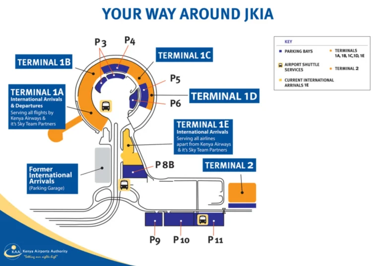
Calgary International Airport Domestic Terminal Map (Most Up-To-Date)
The YYC domestic terminal is a fan-shaped complex of three connected concourses (A, B, C) that feeds into a single long airside connector toward the newer D/E expansion. The whole layout runs roughly east–west, with the biggest scale jump happening at the bridge-like “Connections Corridor” into D. Within Calgary’s main airport hub, the main orientation trick is that “domestic” traffic can still be sent deep into D-gate territory.
Map Table
| Concourse Zone | Gate Letters | Core Nodes | Transfer Tool |
|---|---|---|---|
| A wing | A1–A24 | YYC Link Station A | YYC Link |
| B hub | B31–B40 | retail core | YYC Link |
| C spine | C50–C65 | Station C, Connections Corridor portal | moving walkways |
| D overflow | D70–D97 | Station D/E, corridor terminus | YYC Link |
Calgary International Airport Domestic Terminal Map Strategy
- Treat gate letters as geography: A/B/C stay in the legacy fan, while D is the expansion reached only through the C-side portal and the long connector.
- Budget the A/B/C ↔ D move as a connection risk by default; if your boarding pass shows a D gate for a domestic flight, plan the corridor/YYC Link immediately, not “after a quick check.”
- Reduce checkpoint mistakes by aiming for the single centralized screening entrance (Doors 4–7) and picking the correct lane type before you commit to a queue.
- Assume map-to-gate mismatches can happen in D: trust overhead wayfinding to “D Gates / International” from the C-side node, then confirm gate number again once you reach the D/E hub.
2026 Calgary International Airport Domestic Terminal Map + Printable PDF
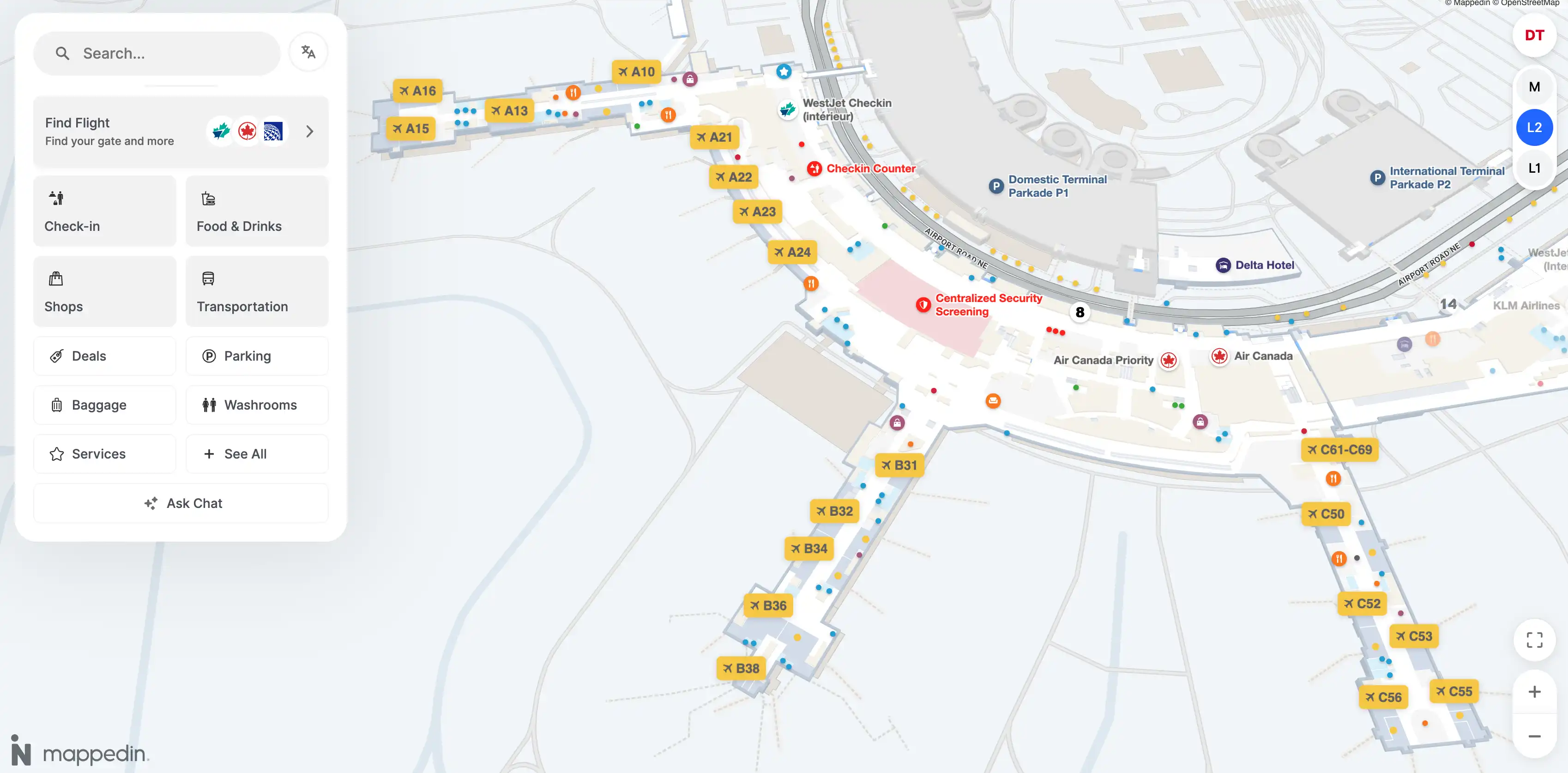
Centralized Security remains the domestic “entry choke,” positioned between Doors 4 and 7 on Departures Level, so every A/B/C gate walk starts from the same release point. The biggest 2026 operational reality is unchanged: “domestic” flights can be assigned to D70–D80 swing gates, forcing a cross-campus airside transfer via Station C and the 620 m Connections Corridor (or YYC Link).
Calgary International Airport Domestic Terminal Level 1 Map 2025
Calgary International Airport Domestic Terminal Level 2 Map 2025
Calgary International Airport Domestic Terminal Mezzanine Map 2025
2026 Calgary International Airport Domestic Terminal Map Guide
What is the exact walking distance (meters) and fastest pedestrian route from Gate D75 to Gate C57 (airside)?
The fastest airside walk is about 1,020 meters via the Connections Corridor, running from the D75 area back to the D/E hub, through the full corridor, and out into Concourse C near the Station C/C70 junction. This is the shortest continuous indoor path that stays sterile and doesn’t require exiting to landside.
From Gate D75, walk west toward the International Departures Hall hub and the signed entrance for “Domestic Terminals A, B, C.” Enter the Connections Corridor and use the moving walkways if they’re running. Exit at the Concourse C side near the Station C node (by the C70 connector area), then continue into Concourse C to Gate C57 near the central C-gates cluster.
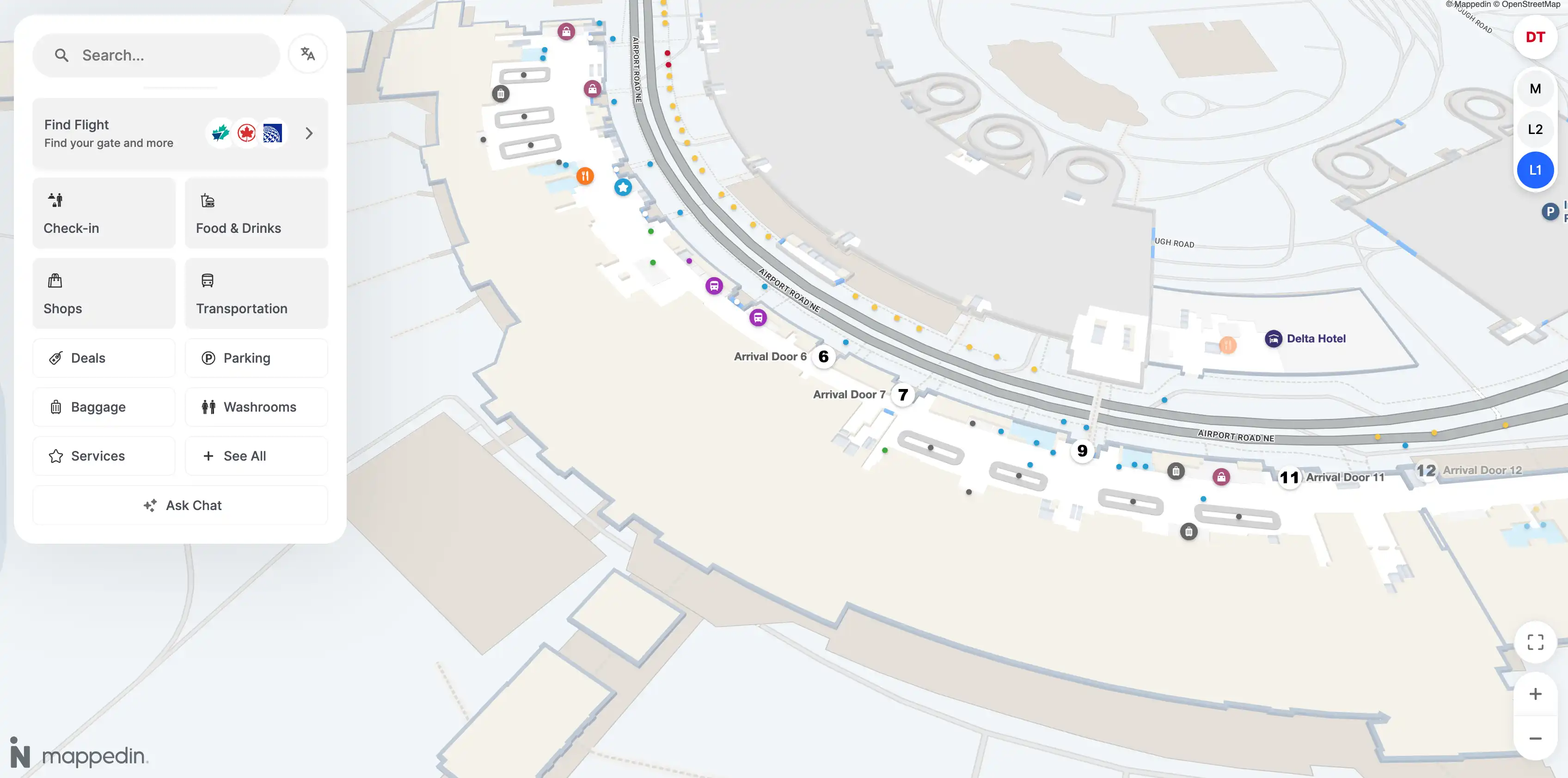
Where is the nearest shuttle/tram stop to the D70–D90 gate cluster, mapped as a single waypoint (pin location)?
The nearest shuttle stop is YYC Link Station D/E in the International Departures Hall, positioned at the central split where the D concourse wing and E concourse approach diverge. This is the single best “pin” for D70–D90 because it’s the hub you naturally pass when heading to either low-70s swing gates or deeper D80s/D90s.
The station sits in the main international atrium, adjacent to the primary wayfinding zone for “D Gates” and “E Gates / U.S.” and functions as the transfer anchor for the YYC Link loop. From most D70–D90 gates, your fastest path is to walk to the central D/E hub first, then branch to your exact gate number.
What is the exact walking time (minutes) from Gate D75 to Domestic Security (A/B/C-side checkpoint) using the shortest indoor route?
Re-clearing Domestic Security is not part of the shortest route because the airside connection from D75 into the A/B/C sterile zone does not require a checkpoint. The shortest indoor path is the airside transfer from D75 to the domestic secure zone via the Connections Corridor, which takes about 12–15 minutes on foot.
From Gate D75, walk back to the D/E hub and follow signs for “Domestic Terminals A, B, C” into the Connections Corridor. Use moving walkways if available, exit on the Concourse C side near the Station C/C70 junction, then continue into the A/B/C secure area. If you truly must reach the landside security entrance (Doors 4–7), you’d need to exit to arrivals/departures levels and then walk back to the centralized screening hall, typically 20–25 minutes plus whatever the queue is.
Where is the physical “request a ride / mobility cart” pickup point nearest to the D gates, mapped to one precise location?
The most reliable single pickup point near the D gates is the YYC Link Station D/E node in the International Departures Hall, because it’s fixed infrastructure and the consistent meet-point used for assisted movement in the D/E hub area. This is the best “pin” when you need one location that staff and wayfinding both recognize.
From the D gates, head toward the central International Departures Hall hub where the concourse splits toward “D Gates” and “E Gates / U.S.” The station area is adjacent to the main information/customer assistance presence in that atrium, making it the practical rendezvous point for dispatched mobility help as well as the YYC Link vehicles.
What is the shortest airside route from Concourse A (A70–A80 area) to the E concourse entry (US preclearance approach), expressed as a single continuous path?
No continuous sterile airside path exists from Concourse A to the Concourse E gate area because entering E requires the US preclearance security/customs firewall. The fastest “airside-to-entry” routing is A concourse to YYC Link Station A, ride to Station D/E, then walk to the US preclearance entrance and proceed into CATSA/CBP screening.
Start at the far end of Concourse A (closest equivalent to the “A70–A80” intent is the A24 end), walk to YYC Link Station A, and take the YYC Link directly to Station D/E in the International Departures Hall. From Station D/E, follow overhead signs for “E Gates / U.S.” to the US preclearance approach corridor and enter the US screening facility. The landmark transition is the D/E hub signage cluster where “D Gates” and “E Gates / U.S.” split.
What is the measured walking distance from the furthest A gates to the E concourse security/entry point (verify the “~15 minutes walk” claim on-map)?
The measured walk from the furthest A gates to the E concourse security/entry point is roughly 1,800–2,000 meters, which makes the “~15 minutes” claim unrealistic for a pure pedestrian route. That time only pencils out if you substitute most of the distance with the YYC Link and hit it with little to no wait.
From the A-end (closest practical reference is the A24 end), the continuous walk runs through the A→B→C domestic spine, then into the 620 m Connections Corridor toward the D/E hub, and finally to the signed “E Gates / U.S.” preclearance entry. Using a brisk pace around 90 meters per minute, 1,800–2,000 meters lands closer to 22–25 minutes before any screening queue.
Where exactly is the centralized screening checkpoint located relative to the A/B/C concourses (single map pin + nearest landmark)?
The centralized domestic screening checkpoint is on Departures Level (Level 2), positioned centrally before the concourse splits to A, B, and C, with the most stable landmark reference being between Doors 4 and 7. This is the single “pin” that replaces older mental models of separate A/B/C checkpoints.
From inside the domestic terminal, it sits directly upstream of the main post-security circulation zone that feeds the A/B/C concourses. Use the Doors 4–7 reference as your landside anchor, then follow the large overhead “Security / Sécurité” signage into the single consolidated queue entry.
From the domestic check-in hall, what is the shortest mapped path to that centralized screening entrance (one route, no branches)?
The shortest route is a straight walk from the domestic check-in counters toward the center of Departures Level to the “Security / Sécurité” entry between Doors 4 and 7. This is the most direct, no-branch path because the centralized checkpoint is intentionally placed as the single funnel for all A/B/C departures.
From the WestJet and Air Canada check-in hall, orient yourself toward the middle of the terminal frontage rather than toward either concourse end. Keep to the main departures floor, follow the largest overhead Security wayfinding, and walk into the centralized queue entrance at the Doors 4–7 segment. For most check-in positions, the walk is under 200 meters.
When a “domestic” flight departs from D gates, what is the fastest post-security route from Domestic Security exits to the D gates corridor (airside connection)?
The fastest route is to clear centralized Domestic Security, turn toward Concourse C immediately, and use the Station C/Connections Corridor node to reach the D/E hub, then enter the D-gates corridor. This is the shortest airside connection because the only sterile link to D runs from the C-side portal.
After security, follow overhead signs pointing toward “D Gates / International” and walk into the Concourse C spine toward the Station C area near the C70 connector node. If a YYC Link vehicle is boarding with no queue, ride from Station C to Station D/E; otherwise enter the Connections Corridor and use moving walkways. You emerge at the D/E hub and then continue down the D wing to your specific D gate number.
What is the single most time-consuming choke corridor (narrow passage / pinch point) on the A–C ↔ D airside transfer route, as seen on the terminal map?
The Connections Corridor segment between Concourse C and the D/E hub is the primary choke corridor because it concentrates all cross-campus foot traffic into one long, finite-width passage with moving walkway merges. This is the transfer’s time sink when flows stack up, especially during peak banks when opposite-direction pedestrian streams and shuttle queuing interact.
The pinch effect shows up most where the corridor begins/ends at the C-side portal near the Station C/C70 junction, because that node mixes turning traffic from Concourse C with through-traffic entering the connector. A secondary slowdown often occurs on the D-side where the circulation funnels through the central departures retail zone before passengers can fully disperse into the D wing.
Where is the nearest restroom waypoint to the midpoint of the A↔D walking route (the “halfway” break point), pinned on-map?
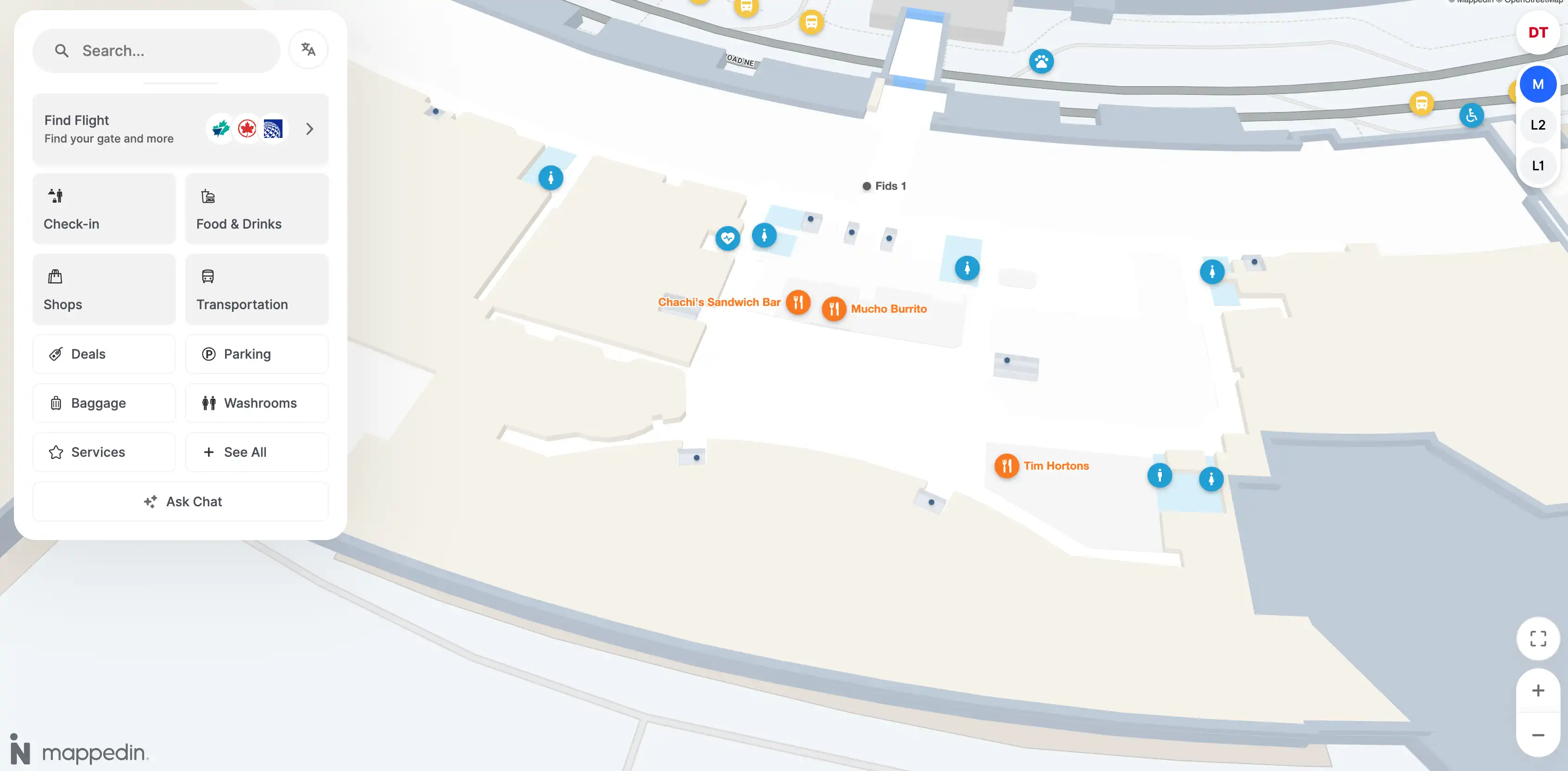
The closest “halfway” restroom waypoint is in the Concourse C retail hub just before the Connections Corridor entrance, near the Relay and Starbucks cluster by the Station C node. This spot works as the midpoint break because it’s the last reliable facility node before the long, comparatively sparse connector into D.
Walking A↔D, the geometric midpoint lands around the B/C transition, but the most practical restroom pin is the C-side retail core adjacent to the corridor portal. Use the Station C/C70 connector area as the landmark, then look immediately around the convenience/coffee storefronts before committing to the 620 m corridor.
Where is the nearest food/convenience cluster to the D-gates-to-domestic transfer corridor, mapped as a single cluster centroid (pin)?
The nearest food/convenience cluster is the Concourse C retail hub at the Station C node, just before the Connections Corridor entrance. This is the best single “centroid pin” because it’s the last dense services pocket on the domestic side immediately adjacent to the transfer funnel into D.
Use the Station C/C70 connector area as your landmark anchor. The cluster is centered around the Starbucks + Relay convenience pairing with nearby quick-service options and the broader Concourse C food court zone. If you’re coming from D toward domestic, this is the first major services node you hit after exiting the corridor.
What is the shortest airside route from Gate D72 to the nearest domestic baggage claim access point (if you must exit airside), measured in meters?
The shortest route is about 800–1,000 meters from Gate D72 via the domestic-arrivals sterile corridor that bypasses customs and drops you into the domestic baggage hall (Carousels 1–10). This is the quickest exit-to-claim path because it avoids the international arrivals processing stream.
From Gate D72, follow “Domestic Arrivals / Baggage Claim” wayfinding rather than “International Arrivals / Customs.” Stay on the dedicated domestic deplaning path, descend to Arrivals Level (Level 1), and continue until you reach the domestic baggage claim access point at the carousel hall entrance. The key landmark is the first major split where “Customs/CBSA” signage appears—do not take that branch for a domestic arrival.
Which specific doorway/portal connects the domestic airside to the D/E airside area (one connector point), and what landmark labels it on the map?
The connector portal is the Concourse C entrance to the Connections Corridor, located at the Station C node adjacent to the C70-area junction. This is the single airside doorway that stitches the legacy A/B/C secure zone to the D/E expansion without going landside.
On maps and overhead signage, it’s labeled with directional wayfinding for “D Gates / International” and the domestic-terminal returns (“A, B, C”), and it’s visually marked by the transition into the glass-walled corridor with moving walkways. Use “Station C” as the most dependable landmark label when you’re hunting the exact portal.