Hartsfield Jackson Atlanta International Airport Domestic Terminal North Map (Most Up-To-Date)
ATL’s Domestic Terminal North is the orange-coded landside half of the Domestic Terminal, stretching west-to-east from the far-west ticketing counters (Southwest-heavy) toward the central Atrium, with security choices split by both side and level. Within Atlanta’s main airport complex, the biggest wayfinding failures happen at two moments: picking the right security entrance (North vs South + program lanes) and exiting to the correct lower-level rideshare corridor that forces a parking-deck walk to the North Economy pickup zones.
Map Table
| Zone | Connection | Walk Time |
|---|---|---|
| Ticketing Level 2 (North) | Southwest / United / American counters | West-to-Atrium span |
| North Checkpoint Level 2 | Standard, airline-status priority | Counters-adjacent |
| Lower North Level 0 | CLEAR (no PreCheck), rideshare tunnel start | Level-change required |
| Baggage Level 1 (North) | carousels, N-doors, vertical cores | terminal-long |
Hartsfield Jackson Atlanta International Airport Domestic Terminal North Map Strategy
- Choose security by program first, then by side: North Level 2 for standard/airline-status priority, Lower North Level 0 for CLEAR without PreCheck, South approach for PreCheck-heavy flows.
- Treat level labels as a gate: “LN” doors for rideshare routing, “N” doors for curb areas; the wrong prefix creates the wrong roadway and the wrong walk.
- For rideshare, commit to the full sequence: baggage level → N2/N3 vertical core → lower level → LN1 exit → crosswalk → parking deck → North Economy zones.
- Reduce time-risk during surges: assume Southwest-west congestion blocks the main east–west aisle near the North checkpoint, and reroute around the queue before you pick a lane or lose your doorway.
2026 Hartsfield Jackson Atlanta International Airport Terminal North Map + Printable PDF
In 2026, Domestic Terminal North remains the non-Delta domestic landside base, with checkpoint capability split across North (Level 2) and Lower North (Level 0), while TSA PreCheck demand continues to push many North-side flyers toward the South checkpoint approach. Rideshare operations still rely on the North Economy pickup model, so the “LN” lower-level exit sequence stays the make-or-break routing step before you ever see zone-numbered signs.
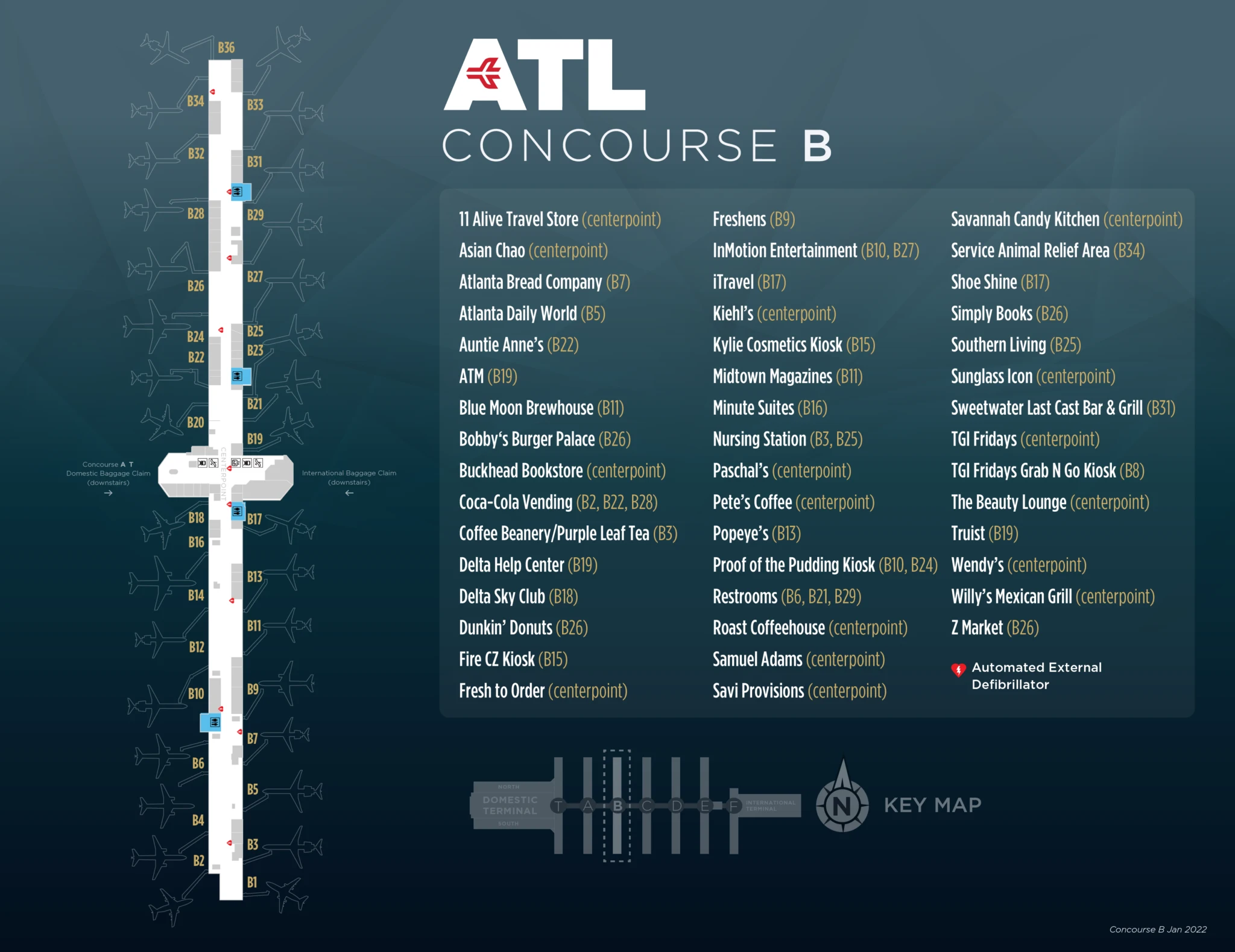
Hartsfield Jackson Atlanta International Airport Domestic Terminal North Concourse B Map 2022-2025
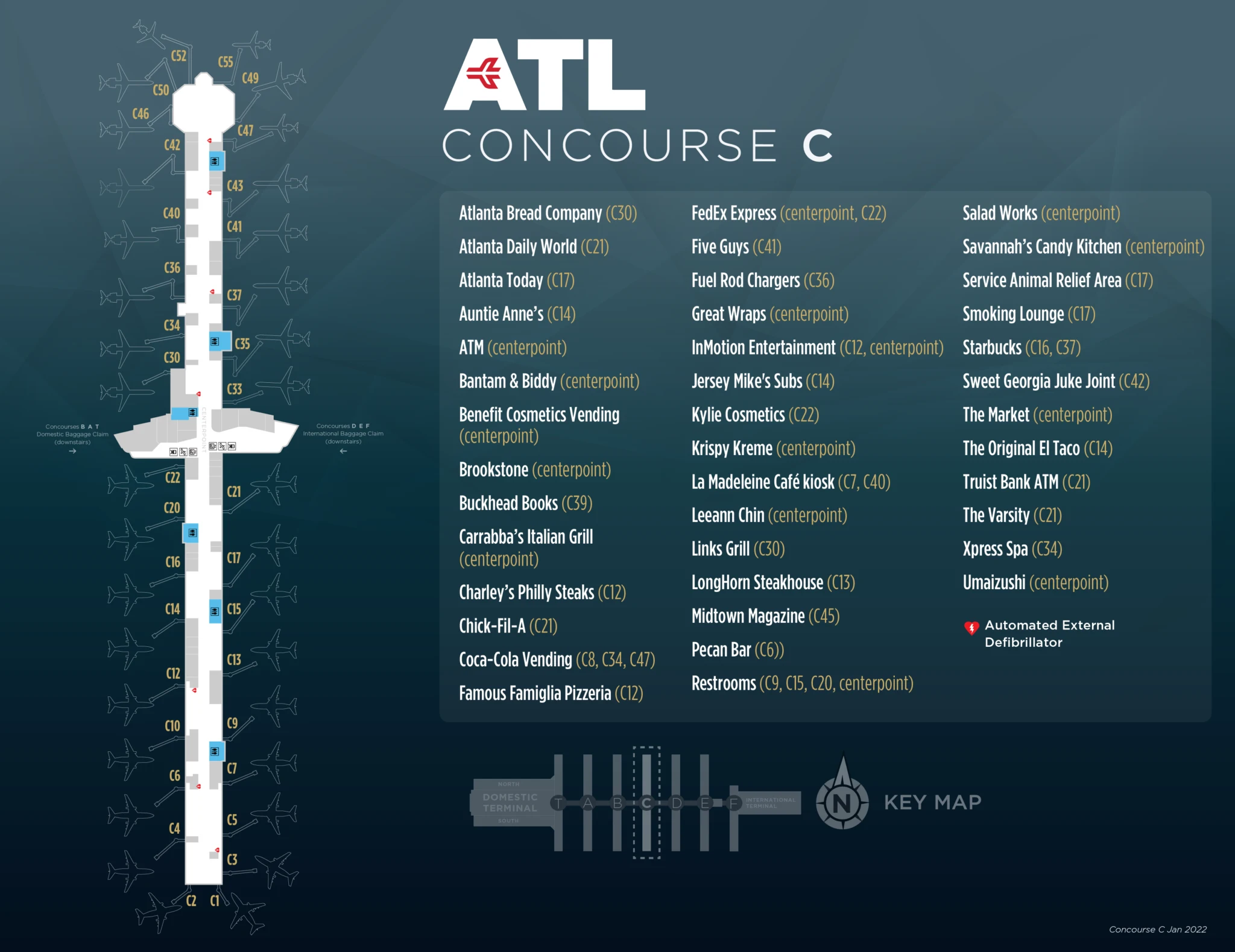
Hartsfield Jackson Atlanta International Airport Domestic Terminal North Concourse C Map 2022-2025
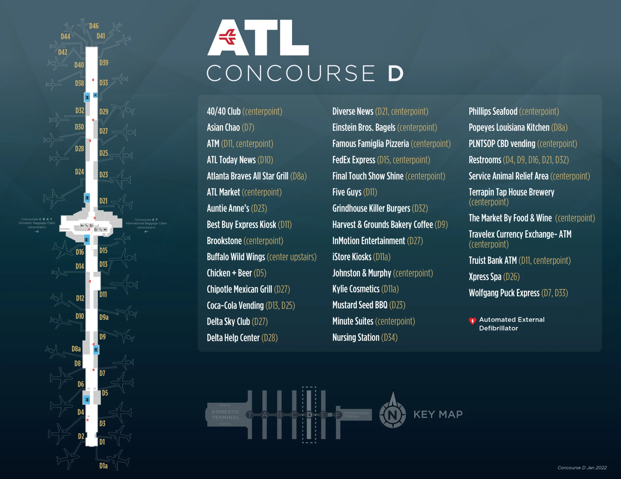
Hartsfield Jackson Atlanta International Airport Domestic Terminal North Concourse D Map 2022-2025
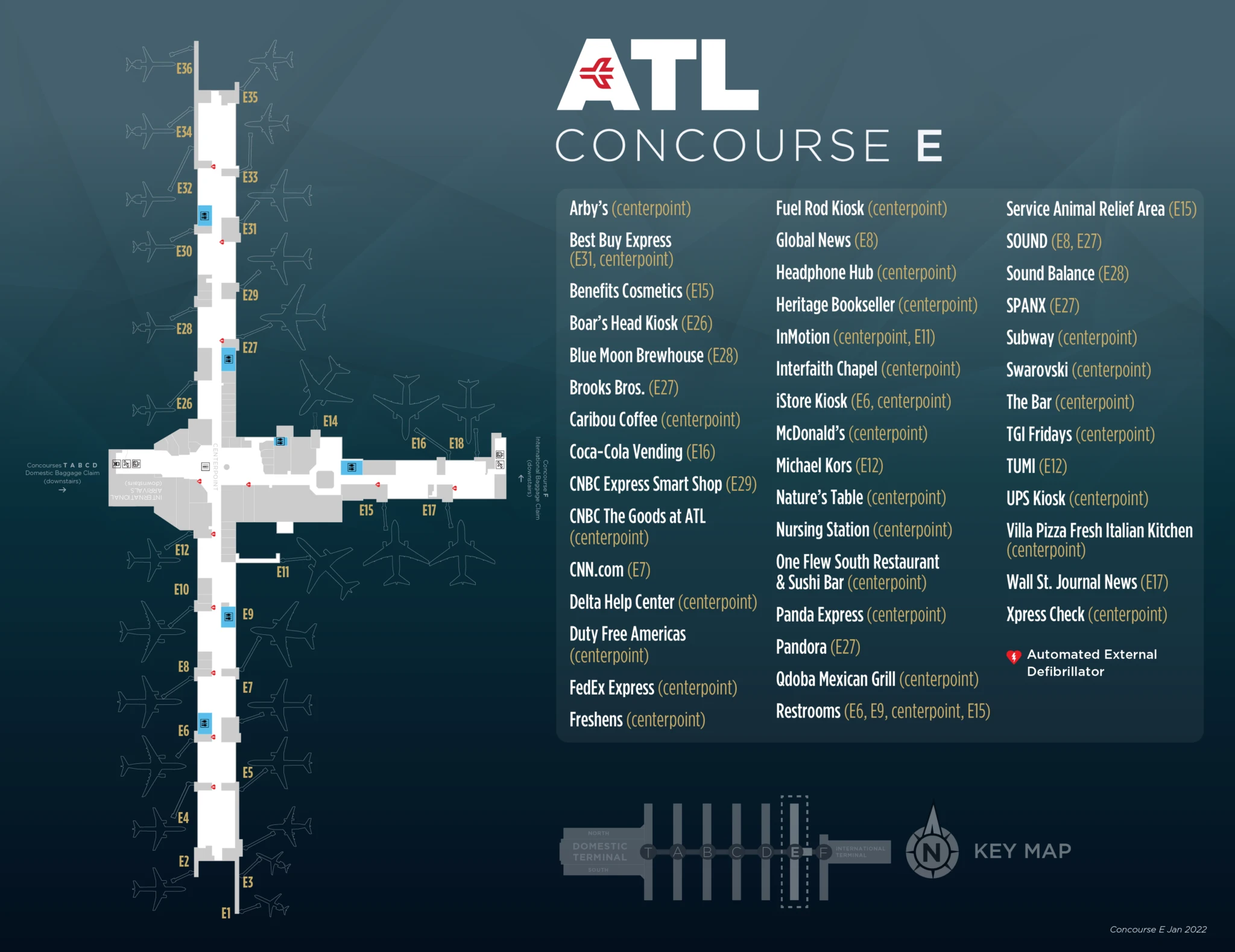
Hartsfield Jackson Atlanta International Airport Domestic Terminal North Concourse E Map 2022-2025
2026 Hartsfield-Jackson Atlanta International Airport Terminal North Map Guide
What is the exact physical position of the Domestic Terminal North Security Checkpoint entrance relative to the Southwest check-in/ticketing area?
The Domestic Terminal North Security Checkpoint entrance sits on Level 2 just east of the Southwest ticketing footprint, at the east end of the west-side counter banks where passenger flow turns toward the Atrium. From the Southwest counters, it’s the first major security entrance you reach when you walk east toward the central Domestic Atrium.
The checkpoint is best triangulated by the west ticketing run: Southwest occupies the far-west counters, and the North checkpoint entrance is roughly one short concourse-length walk east of the furthest-west Southwest positions (about 200 feet). In peak periods, Southwest bag-drop lines commonly expand into the “West Crossover” aisle and can physically press up to the North checkpoint entrance, which is why travelers trying to cut across toward the Atrium sometimes get forced into a detour around the queue.
Where is the CLEAR (no PreCheck) lane located at ATL’s domestic side—which level and which checkpoint approach (North side placement)?
The CLEAR (no PreCheck) lane is at the Domestic Lower North Security Checkpoint on Level 0, not at the Level 2 North checkpoint. That lower-level checkpoint is the dedicated domestic-side access point for CLEAR members who do not have TSA PreCheck.
From Domestic Terminal North ticketing (Level 2), the approach is a level-change route: walk toward the west end of the domestic ticketing hall (toward the T-gates/InMotion-area direction), then take the down escalator/elevator bank to the Lower Level corridor that feeds the Lower North checkpoint entrance. If you queue at the Level 2 North checkpoint with CLEAR (no PreCheck), you typically get redirected downstairs, which is the common “wrong-lane, wrong-level” failure at ATL North.
From North baggage claim, which specific escalator/elevator bank leads to the lower level rideshare exit path?
The escalator/elevator bank between Doors N2 and N3 leads from North baggage claim down to the Lower Level rideshare exit path. That N2/N3 vertical core is the reliable landmark for starting the LN-door sequence used for the North Economy rideshare routing.
From the carousels on Level 1 (North baggage claim), stay inside the building and walk toward the curbside door numbering until you’re centered between N2 and N3. Use that bank to descend to Level 0, then orient immediately to the “Lower North” door labels (LN-series) rather than the arrivals curb N-series. This is the vertical move most people miss when they try to exit directly to curbside for rideshare.
What is the exact door label you must exit (e.g., LN1) to reach the official rideshare pickup route from Domestic Terminal North lower level?
Door LN1 is the required exit for the official rideshare pickup route from Domestic Terminal North on the Lower Level. That LN1 doorway is the alignment point for the designated crosswalk that feeds the parking-deck walk toward the North Economy rideshare zones.
LN1 is a “prefix test” that prevents wrong-level errors: if the door sign reads N1/N2/N3, you’re not on the lower rideshare routing level, and you’ll end up on the wrong roadway face for the consolidated pickup. The correct sequence is Lower Level (Level 0) → exit LN1 → crosswalk over the lower roadway → enter the North parking deck → follow orange directional wayfinding through the deck → cross to the North Economy lot where the zone-numbered pickup signs begin.
What is the walking distance from the North checkpoint exit of security to the Plane Train escalators (post-security transition point)?
Walking takes about 150 feet from the North checkpoint exit to the main escalator bank down to the Plane Train spine. That short post-screening walk ends at the escalator header that drops from the secure-side Level 2 area into the subterranean Transportation Mall.
After you exit screening at the Domestic North checkpoint, you recompose in the secure-side atrium edge, then walk straight toward the central down-escalators. The vertical descent itself is roughly 45–60 seconds, and most travelers can budget about 2–3 minutes total from stepping off the X-ray belt to standing on the Plane Train platform, with the escalator bank serving as the key landmark transition.
In the North Economy rideshare pickup area, where are the zone-numbered pickup signs positioned relative to the pedestrian entry path?
The zone-numbered pickup signs are positioned immediately alongside the pedestrian entry edge of the North Economy lot, flanking the lanes you step into after crossing from the parking deck. As you enter the open-air lot from the deck-side crosswalk, the bright orange zone markers appear in your forward field of view, distributed left and right across the first rows of pickup positions.
The easiest triangulation is the “second crosswalk moment”: you exit the terminal at LN1, cross into the parking deck, follow the orange wayfinding through the deck, then cross out into the North Economy surface lot. Right after that lot-entry crossing, the zone stanchions/columns are spaced through the pickup grid so you can walk straight to your assigned zone number without backtracking toward the deck.
If you arrive at South baggage claim (Delta-side), what is the shortest indoor path (pre-security) to reach the North-side rideshare routing corridor toward the consolidated pickup?
The shortest indoor path stays on Level 1 through the Atrium before you descend to the Lower Level. Starting at South baggage claim (Delta side), walk west into the central Domestic Atrium connector, cross the Atrium into the North baggage claim hall, then use the N2/N3 escalator/elevator bank to go down to Level 0 and exit at LN1 for the rideshare route.
The key constraint is that the “side correction” must happen before the level change: the public indoor crossover is effectively the Atrium/baggage level connector, not a lower-level tunnel between South and North. Once you reach North baggage claim, the N2/N3 vertical core is the landmark that hands you off into the LN-door system that feeds the parking-deck walk to the North Economy pickup zones.
Where is the most common “wrong pickup pin” location compared to the official rideshare pickup entrance, and what’s the map-visible divergence point where people realize they’re wrong?
The most common wrong pickup pin is the terminal arrivals curb outside North baggage claim doors on Level 1, where travelers assume Uber/Lyft still pick up curbside. That pin is wrong because the official rideshare entrance is the Lower Level LN1 exit that starts the parking-deck walk to the North Economy lot.
On the map, the divergence becomes obvious when the passenger’s blue dot sits at the terminal face while the driver icon routes to (or sits inside) the North Economy lot access lanes on the far side of the parking deck. The “realization point” is typically when the passenger sees the car moving away or appearing “behind” a concrete block on the map—because the deck structure and access roads separate the terminal roadway from the Economy pickup grid—forcing a backtrack inside to the N2/N3 vertical core, then down to LN1 to rejoin the correct pedestrian corridor.
Where exactly is the premium/priority entry located within the North terminal, and which checkpoint entry point does it feed into?
The premium/priority entry is the dedicated Priority Screening Lane at the Domestic Terminal North Security Checkpoint on Level 2. That priority entry feeds directly into the same North checkpoint screening area as the standard queue, just via a separate lane for airline-status and premium-cabin passengers.
In practice, the landmark is the Level 2 North checkpoint entrance adjacent to the North-side ticketing counters: the Priority lane is signed at that entrance and runs parallel to the standard approach. The critical “lane-choice” detail is that this is not a TSA PreCheck substitute—priority at the North checkpoint is an airline-status bypass that still uses standard screening rules—so PreCheck holders typically do better by using the South checkpoint approach instead of taking the North priority entry.
When Southwest check-in lines back up, what is the furthest physical landmark they reach, and which walkway becomes blocked?
The furthest landmark the Southwest check-in line typically reaches is the Domestic Terminal North Security Checkpoint entrance on Level 2. When the queue wraps beyond the stanchions, it can expand into the “West Crossover” area and press up to the checkpoint approach.
The walkway that becomes blocked is the main east–west circulation aisle in front of the west ticketing counters—the corridor that people use to move from the Southwest-heavy west end toward the central Atrium. In the worst backups, travelers trying to cut across end up forced into a slow detour around (or through the edge of) the check-in queue, which is why the checkpoint entrance itself becomes the practical “this is as far as the line goes” landmark.
For non-rideshare curb pickup on the North side, what are the door-number reference points along the arrivals curb that a passenger should use to coordinate a pickup spot?
Door LN1 and Door LN2 are the most reliable North-side arrivals curb reference points for coordinating a non-rideshare pickup. Those Lower North (LN) door labels anchor the lower roadway curb where private vehicles can briefly load passengers.
Use the door prefix to avoid a wrong-level meetup: “LN” indicates the Lower Level curb face, while “N” doors indicate the baggage claim level exits that can put you on a different curb position than your driver expects. A clean coordination script is to have the passenger stand curbside at LN1 (or LN2 if congestion is heavy) only when the driver is on the lower roadway approach, because stopping is active-loading only and drivers typically need to keep circling until the passenger is physically at the LN door.
Where are travelers most commonly approached by unofficial rideshare solicitations—which ground-transport choke point or exit corridor near Domestic Terminal North?
The most common unofficial rideshare solicitation spot is the Lower Level arrivals curb immediately outside Door LN1. That LN1 curb area functions as a choke point because it’s where tired travelers emerge expecting an easy pickup, right at the start of the long walk route to the North Economy rideshare lot.
Solicitors also concentrate in the nearby indoor corridors that funnel people toward ground transportation flows, but the highest-frequency interception point is the LN1 exit zone itself—where someone can plausibly offer “no walking” rides. A practical safety cue is platform logic: official Uber/Lyft pickups are geofenced to the North Economy pickup operation, so anyone offering a ride at the LN1 curb is operating outside the app-based pickup workflow.
Archive Hartsfield-Jackson Atlanta International Airport Terminal North Map
Below are all historical map versions for Hartsfield-Jackson Atlanta International Airport. Each year includes the official map available for that period, presented as both WebP and PDF.
2022-2025 Hartsfield Jackson Atlanta International Airport Domestic Terminal North Map (Official 2022 Edition)
2019 Hartsfield Jackson Atlanta International Airport Domestic Terminal North Map
2013 Hartsfield Jackson Atlanta International Airport Domestic Terminal North Map