Charles de Gaulle International Airport Terminal 2 Map (Most Up-To-Date)
CDG Terminal 2 is a long, curved “region” within the main Paris–Charles de Gaulle hub, made of multiple sub-terminals (2A–2G) plus Terminal 2E split into three separate halls (K, L, M) connected by the LISA airside train. The whole complex stretches across the central “Gare” (TGV/RER) spine, with roads and security borders cutting clean lines between areas. Scale warning: this is not a single building—hall choice can add 20–45 minutes.
Map Table
| Zone | Connection | Walk Time |
|---|---|---|
| 2E Hall K (Headhouse) | 2F glass connector tube; LISA station to L/M; airside bus nodes | 2F connector ~10 min; to LISA platform ~5–10 min |
| 2E Hall L (Satellite S3) | LISA train (K ↔ L ↔ M); limited airside bus links (ops-dependent) | LISA ride to K ~4–8 min; platform + level changes ~5–10 min |
| 2E Hall M (Satellite S4) | LISA train only to K/L; Red bus node to 2G (time-windowed) | LISA segment to K total ~15–20 min (incl. vertical) |
| 2F (Schengen hub) | 2E connector + security + PAF; Orange airside bus to 2G; N2 landside to 2G | 2E↔2F baseline 30–40 min (queues variable) |
| 2G (Satellite outpost) | Orange/Yellow/Red airside buses; N2 landside bus; entrance security at 2G | bus ride 10–15 min; 2G entry security +15 min buffer |
| Gare CDG2 (Level 4) | pedestrian distributor: 2C/2D, 2E/2F corridors; Sheraton axis | 2E/2F ~300 m; 2C/2D ~400 m; 2A/2B ~700–800 m |
Charles de Gaulle International Airport Terminal 2 Map Strategy
- Treat “2E” as three different places (K vs L vs M); confirm the hall letter first, then commit to LISA vs connector routes.
- Assume at least one hard boundary on any 2E move: security re-screening and/or passport control can sit right in the connector flow and cannot be bypassed once you enter it.
- For 2G, plan the trip like a mini-connection: find the correct bus color/stop before you start walking, and budget extra time for 2G entrance security.
- On bus transfers, anchor yourself to the exact bay/stop name on the “Correspondance” display; “wrong bus / wrong drop-off” is the main trigger for surprise second-bus loops and backtracking.
2025 Charles de Gaulle International Airport Terminal 2 Map + Printable PDF (Official 2018 Edition)
In 2025, the Terminal 2 complex is operating as a multi-module hub: 2E remains split into K/L/M with the LISA train as the functional connector, and 2G remains non-walkable from the main complex (bus-only access). Day-to-day operations (especially airside shuttle colors/stops and queue placement for security/PAF) can shift, so the “Correspondance” screens and in-terminal wayfinding boards are the final authority.
Charles de Gaulle International Airport Terminal 2A Arrivals and Departures Map 2025-201
Charles de Gaulle International Airport Terminal 2C Arrivals and Departures Map 2025-2018
Charles de Gaulle International Airport Terminal 2D Arrivals and Departures Map 2025-2018
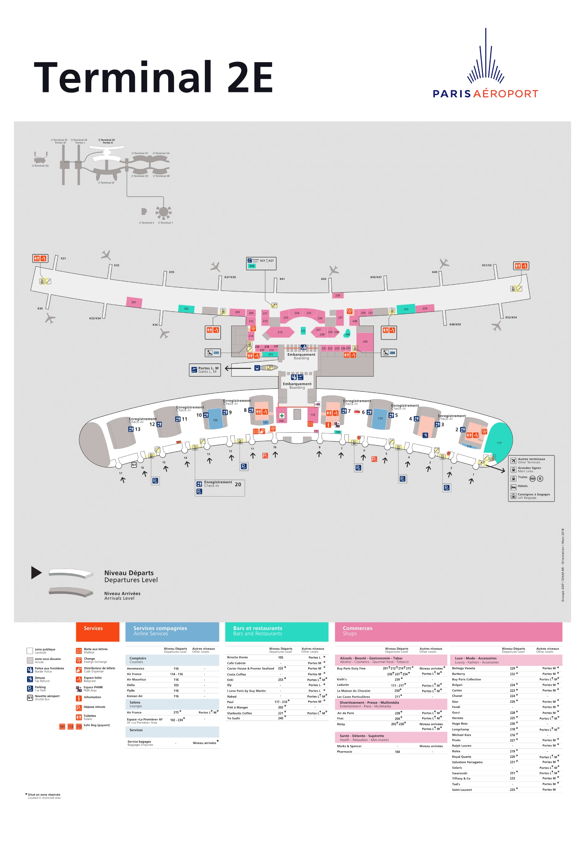
Charles de Gaulle International Airport Terminal 2E Arrivals and Departures Map 2025-2018
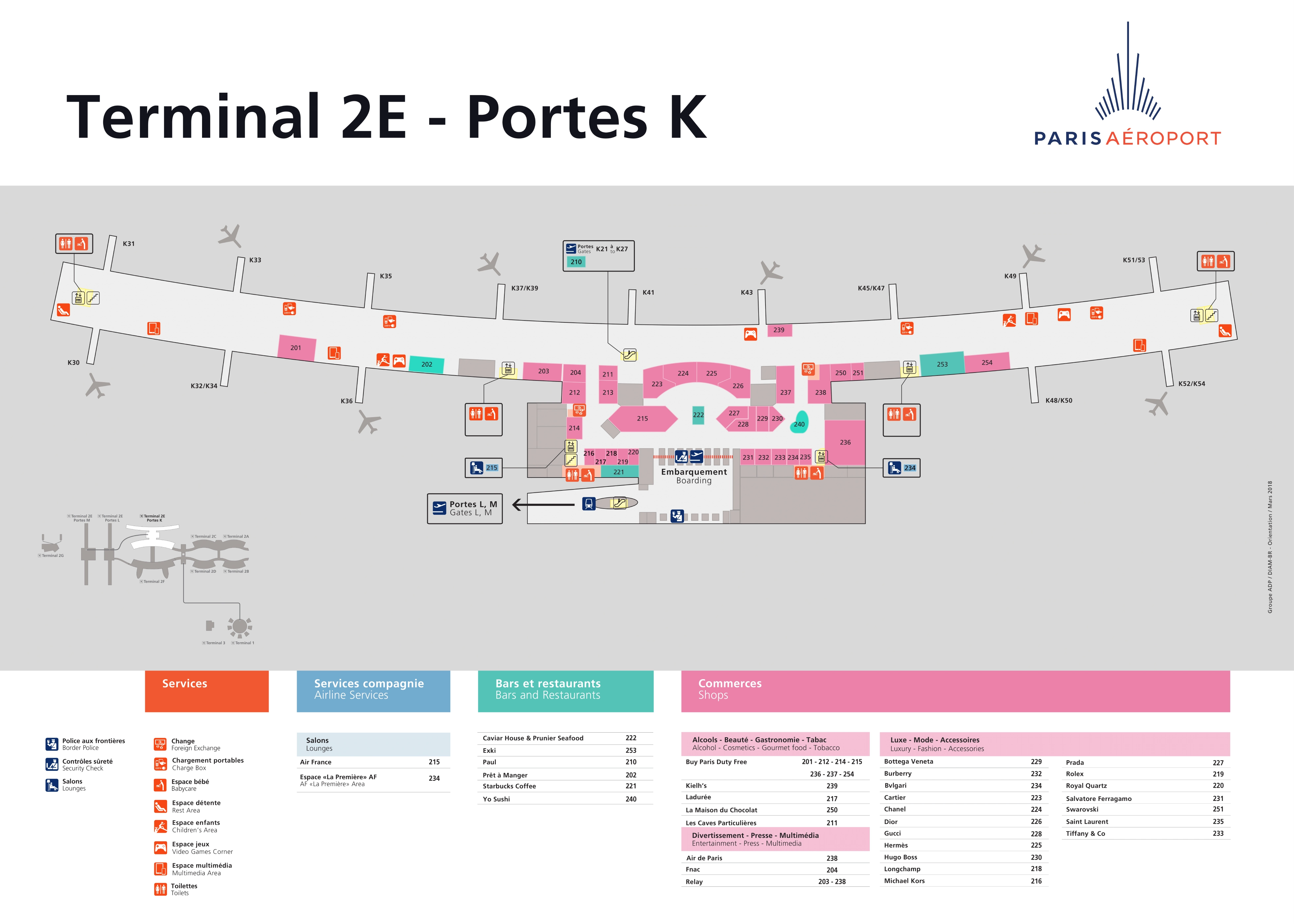
Charles de Gaulle International Airport Terminal 2E Port K Arrivals and Departures Map 2025-2018
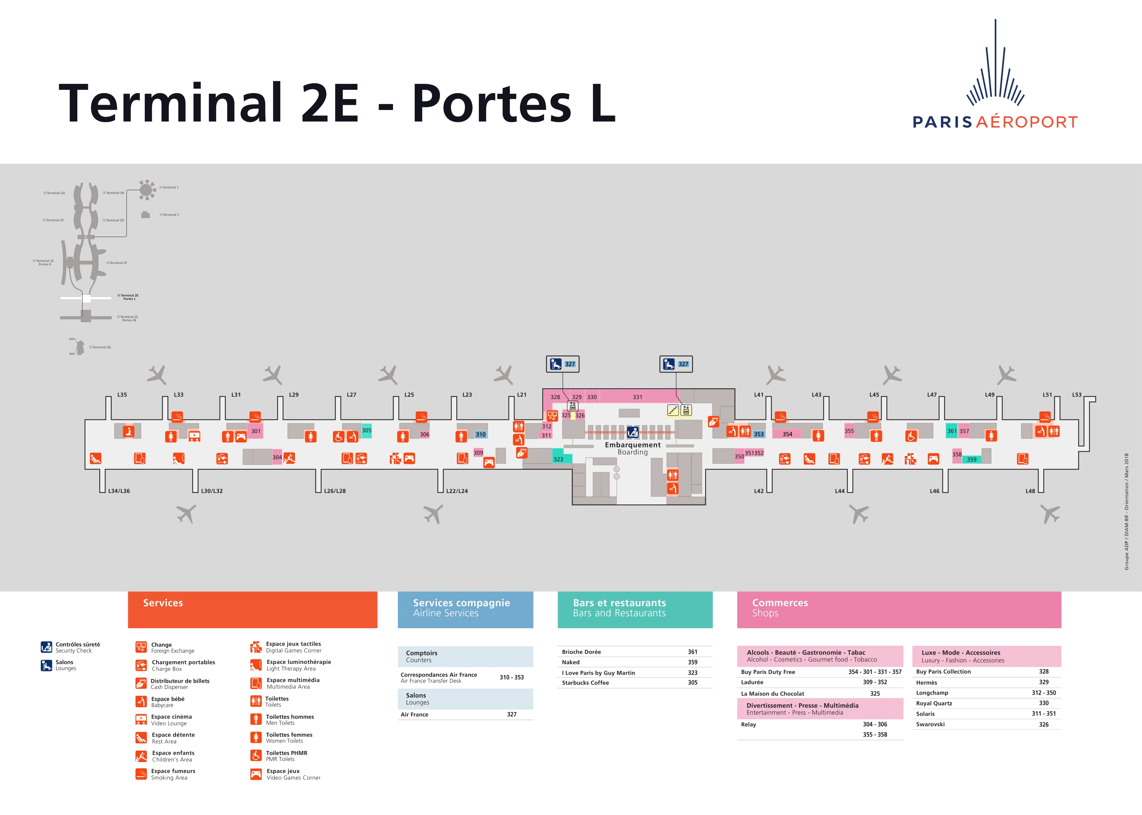
Charles de Gaulle International Airport Terminal 2E Port L Arrivals and Departures Map 2025-2018
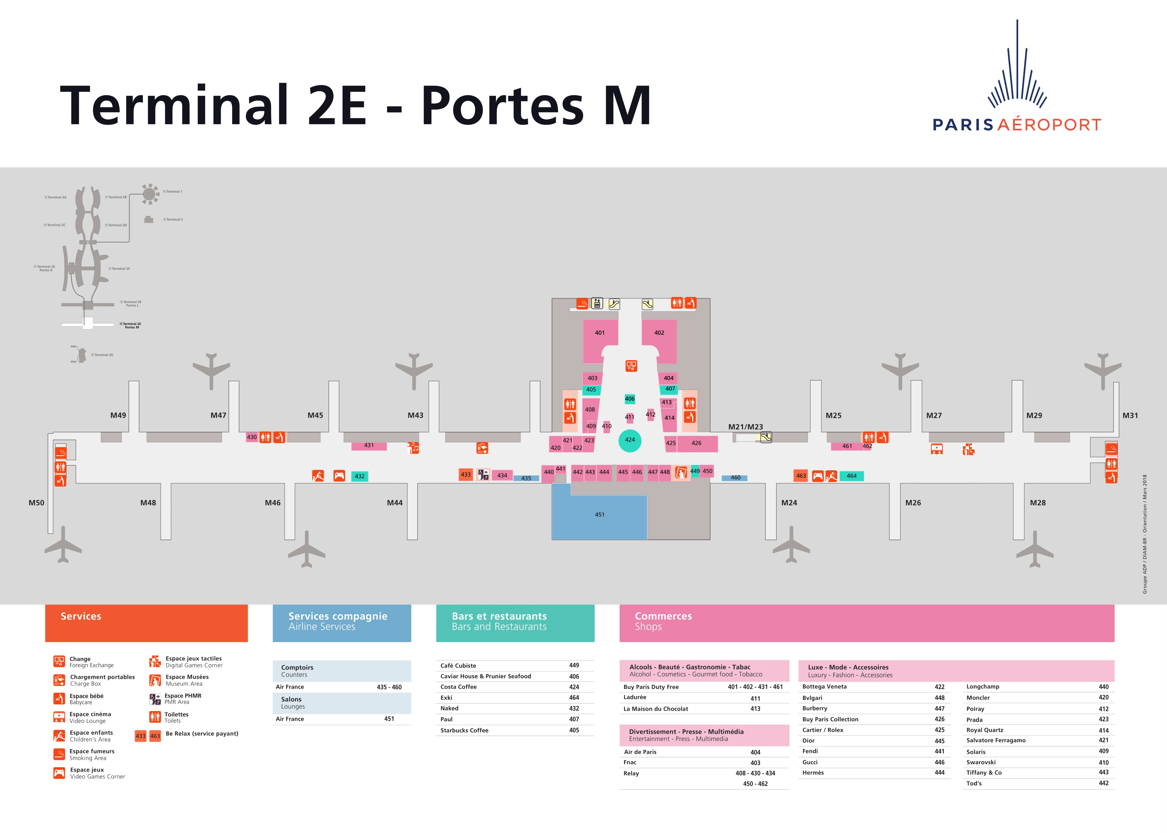
Charles de Gaulle International Airport Terminal 2E Port M Arrivals and Departures Map 2025-2018
2025 Charles de Gaulle International Airport Terminal 2 Map Guide
What is the exact path (including level changes) from Terminal 2E arrivals to the connector that allows moving between halls K, L, and M, and where is the security checkpoint that blocks that movement?
Moving between 2E Hall K ↔ Hall L/M is controlled by the LISA airside train (K–L–M) and its underground station access, and moving between “arrivals landside” and “airside connectors” is blocked by a one-way security boundary at the point you re-enter the departures/transfer system. If you exit into public arrivals, you cannot access K/L/M airside connectors without clearing security again.
| Segment | Exact waypoints | Level change |
|---|---|---|
| 2E Arrivals (K) → Transfers | Arrivals flow → follow yellow “Correspondance/Transfers” → escalators/lifts toward transfer level | Up to departures/transfer level |
| Transfers → LISA (to L/M) | Follow “Gates L / Gates M” → LISA access portals → descend to LISA platform | Down to underground LISA station |
| LISA platform → Hall L or M | Board LISA toward Satellite S3 (L) or S4 (M) | Train ride; then up from platform to concourse |
| Where movement gets blocked | Any attempt to go from public arrivals/landside back into K/L/M departures/transfer corridors | Security re-screening at the re-entry point to the secure departures/transfer area (before you can access LISA/connector routes) |
Where is the physical boarding point (door/zone) for the shuttle bus to Terminal 2G when starting from Terminal 2E, and what is the mapped walking distance from the main 2E transfer corridor to that bus stop?
The Terminal 2G shuttle from Terminal 2E boards airside at Terminal 2E Hall K’s transfer bus gates (“2E Gate K” on shuttle registries), not from the public curb, and it’s reached by following yellow “Correspondance / Navettes” signs to the bus-gate zone. The walk from the main 2E transfer corridor is usually a short internal walk, but the airport does not publish a single fixed “mapped” distance for every starting point inside 2E.
| Step | Waypoint you should see | Level change | Typical in-terminal walk |
|---|---|---|---|
| 1 | 2E transfer corridor → yellow “Correspondance/Transfers” flow | none | — |
| 2 | Split point signage for shuttles → “Navettes / Terminal 2G” | none | ~3–6 min |
| 3 | “Correspondance” bus-gates area at 2E Hall K (Gate K) | sometimes down to bus-gate level | ~2–4 min |
| 4 | Board the bus that explicitly shows “2G” on the bay display | none | — |
When transferring 2E → 2D by bus, where is the first bus pick-up point after following “Transfers” signage, and what is the exact location/name of the drop-off area where travelers get confused (the place that doesn’t clearly look like “2D”)?
You typically must go landside and re-clear security; there isn’t a simple “stay-airside” bus straight into 2D for most itineraries. The first practical pick-up point is the N1 landside shuttle stop at Terminal 2E, Exit 16, and the confusing drop-off is the Terminal 2B/2D stop at Exit D6 (Porte D6), which reads more like a shared curb than “Terminal 2D.”
| Waypoint sequence | What to look for (anchor point) |
|---|---|
| Follow “Transfers” → exit to public side | Arrivals/public corridor that feeds curbside exits |
| Bus pick-up | Terminal 2E – Exit 16 curbside stop marked N1 |
| Bus ride | N1 loop toward 2B/2D |
| Confusing drop-off | Terminal 2B/2D – Exit D6 (Porte D6) curbside stop (often reads “2B/2D,” not “2D”) |
| After drop-off | Walk in via the nearest doors signed 2D / Gates D from the shared 2B/2D frontage |
What is the exact indoor walking route between Terminal 2B and Terminal 2E (landside), and what is the measured walking time/distance end-to-end using the mapped walkway network?
Walking takes about 15–20 minutes end-to-end on the landside indoor network if you stay on the Gare CDG2 Level 4 distributor level and do not descend to the train platforms. The effective walking distance is roughly 1.2–1.6 km, depending on your exact door (2B side) and which 2E entrance you use.
| Segment | Waypoints (landside indoor) | Distance / time |
|---|---|---|
| 2B exit → Gare access | Terminal 2B public hall → follow signs for “Gare SNCF / TGV–RER” | ~5–8 min |
| Gare Level 4 traverse | Stay on Level 4 → pass the Sheraton frontage/atrium | ~5–7 min |
| Gare → 2E corridor | Follow “Terminal 2E / 2F” corridor with moving walkway | ~5–7 min |
| Arrive 2E | Enter 2E public area (before security) | ~15–20 min total |
On a 2E ↔ 2F connection, where exactly do you hit passport control versus security re-screening along the mapped route (before or after the main connector/train segment)?
Security re-screening is usually first, and passport control is usually after, on the main 2E→2F transfer flow. The key exception is that your exact sequence can vary by origin (Schengen vs Non-Schengen) and whether you’re coming from 2E K versus the L/M satellites, but the choke points sit on the 2E/2F connector approach rather than inside the long LISA train segment.
| Direction | Main connector segment | Security re-screening | Passport control (PAF/PARAFE) |
|---|---|---|---|
| 2E → 2F (Non-Schengen to Schengen) | Walk the 2E↔2F glass connector (from 2E K area) | At the 2E→2F processing “pit” before you enter 2F’s secure Schengen flow | Immediately after security, before you climb into the 2F atrium |
| 2F → 2E (Schengen to Non-Schengen) | Walk the same connector back toward 2E | Not typical unless your onward segment requires it | Border exit control occurs as you leave Schengen, on the connector/processing approach |
From any Terminal 2 sub-terminal (2C/2D/2E/2F), what is the exact mapped route to the Aéroport Charles de Gaulle 2 TGV / RER station, and which sub-terminals have the shortest/longest walking distance?
The Aéroport Charles de Gaulle 2 TGV / RER station is reached shortest from Terminal 2E or 2F (about 300 m via the Level 4 distributor corridors) and longest from Terminal 2C or 2D (about 400 m). The “correct” path is staying on the pedestrian distributor level and aiming for the Sheraton atrium above the station, not descending to platforms.
| Start terminal | Exact route to the station | Distance rank |
|---|---|---|
| 2E | Public hall → follow “Gare SNCF / TGV–RER” → enter the wide corridor with moving walkway → station atrium at Sheraton Hotel (Level 4) → escalators down to ticketing (Level 2) or platforms (Level 1) | shortest |
| 2F | Public hall → follow “Gare SNCF / TGV–RER” toward the central atrium → arrive at Sheraton Hotel (Level 4) above the station → descend to ticketing/platforms | shortest |
| 2C | Public hall → follow “Gare SNCF / TGV–RER” toward the central atrium → pass the main flight info screens near the station void → reach Sheraton (Level 4) → descend | longest |
| 2D | Public hall → follow “Gare SNCF / TGV–RER” toward the central atrium → stay on the Level 4 terminal-connector galleries (avoid any “RER B / quais” down ramps) → reach Sheraton (Level 4) → descend | longest |
For a tight 2G → 2E-K connection, what is the mapped distance from the 2G arrival point to the 2G shuttle bus stop, and from the bus drop-off to the 2E-K transfer entrance (to compute worst-case buffer)?
The walking pieces are short but variable: 2G arrival → 2G shuttle stop is typically 2–4 minutes, and 2E bus drop-off → 2E-K transfer corridor is typically 5–8 minutes. The real dealbreaker buffer is usually 2G entry security (+~15 minutes), not the walking.
| Segment | Anchor points you can triangulate | Worst-case on-foot time |
|---|---|---|
| 2G arrival point → 2G shuttle stop | Bus/terminal arrival frontage → follow “Navettes / Correspondance” to the marked bus bay area near the 2G entrance | ~4 min |
| 2E Hall K bus drop-off → 2E-K transfer entrance | Drop-off at 2E (Gate K) shuttle zone → follow yellow “Correspondance/Transfers” toward Gates K | ~8 min |
Where are the access-control points that enforce “you must have a valid boarding pass for 2E K/L/M” (or similar restrictions), and what is the exact boundary line where that rule starts being enforced?
The rule starts being enforced at the first security/access portals that separate public areas from the secure departures/transfer system for 2E Hall K, and again at the LISA satellite entry controls for Halls L and M. Once you pass these portals, you are inside a boarding-pass-controlled zone that you can’t freely “browse” without an eligible flight.
| Controlled zone | Access-control point | Boundary line (where it begins) |
|---|---|---|
| 2E Hall K secure departures | Boarding pass check + security entry at the 2E departures/transfer security entrances | The door line at the entrance to security (public hall → security queue) |
| LISA access to Hall L | LISA entry portals signed “Gates L” in the 2E secure area | The portal line immediately before the descent to the LISA platform |
| LISA access to Hall M | LISA entry portals signed “Gates M” in the 2E secure area | The portal line immediately before the descent to the LISA platform |
If you follow signs for a bus transfer inside Terminal 2 after security, what is the exact sequence of waypoints (checkpoint → bus bay → drop-off corridor → next transfer node) that prevents the “another bus” surprise travelers report?
The safest way to avoid the “another bus” surprise is to treat the Correspondance screens as the authoritative node: they tell you the correct color line and bay for your exact destination (2G vs 2B/2D vs 2E satellite). If you board the wrong loop (especially the broad Blue loop), you can be dropped at a shared frontage that forces a second shuttle.
| Step | Waypoint you must hit | What to verify on signage |
|---|---|---|
| 1 | Post-security transfer corridor (yellow “Correspondance”) | Destination terminal letter/number + gate letter (K/L/M/G) |
| 2 | “Correspondance” information screens before bus gates | Shuttle color + terminal + stop name (don’t rely on “2” alone) |
| 3 | Correct bus bay in the secure bus-gates zone | Bay display shows your terminal (e.g., “2G”) not a generic loop |
| 4 | Bus drop-off frontage | Stop name matches the screen (e.g., “2G Main Entrance” or “2B/2D Porte D6”) |
| 5 | Drop-off corridor into the next node | Follow the first internal sign that names the gate pier (e.g., “Gates K” / “Gates F” / “2G Security”) rather than “Terminal 2” |