Theodore Francis Green State Airport Map (Most Up-To-Date)
Theodore Francis Green State Airport (PVD) is a compact, single-terminal, two-level building with a central atrium “neck” that funnels all departing passengers into one TSA checkpoint. Landside runs as a straight curb frontage on Level 1 (Arrivals), while Level 2 (Departures) sits directly above with ticketing and security. Airside splits from the post-TSA food-court node into two linear concourses: shorter South (Gates 1–8) and longer North (Gates 9–22) within Rhode Island’s primary air-travel hub.
Map Table
| Terminal | Key Airlines | Primary Function | Transfer Mode |
|---|---|---|---|
| Single terminal | Southwest, Delta, United, JetBlue, American | Level 2 departures + TSA | Level 1 curb, Skywalk to InterLink |
| North Concourse (Gates 9–22) | Major domestic banks | Longest walk, pier expansion | Walk only |
| South Concourse (Gates 1–8) | Regional + domestic | Closest gates to core | Walk only |
| InterLink (off-terminal) | Rental car agencies | Rail + rental car hub | Enclosed Skywalk, moving sidewalks |
Theodore Francis Green State Airport Map Strategy
- Treat TSA as the terminal’s single point of failure: when the line stretches, the tail can reach back toward the entrance vestibules past the ticket-counter blocks, so pick a landmark before you commit to a lane and don’t cut across the stanchion field mid-hall.
- Hard-code the InterLink transfer: the enclosed Skywalk to the rail/rental-car facility is about 1,200 feet, and the worst-case becomes a missed-flight trap when combined with morning TSA spikes.
- Enforce level discipline for pickups: Arrivals is Level 1, and decision-node mistakes (wrong curb, wrong island, wrong lane) create “loop” behavior where you and your ride never align.
- Use curb-side anchors, not vague descriptions: pillar numbers and distinct signage/curb islands beat “outside baggage claim,” especially at rideshare, Lot E shuttles, and Skywalk/garage transitions.
2026 Theodore Francis Green State Airport map + Printable PDF
PVD remains a single-checkpoint, single-terminal airport where the most meaningful “map change” is operational: security backups can spill deep into the departures hall during peak banks, and ground-transport rules punish wrong-level choices. For printable planning, treat the InterLink Skywalk as a real transit leg (not “next door”), and treat Arrivals Level 1 as the pickup default unless signage explicitly says otherwise.
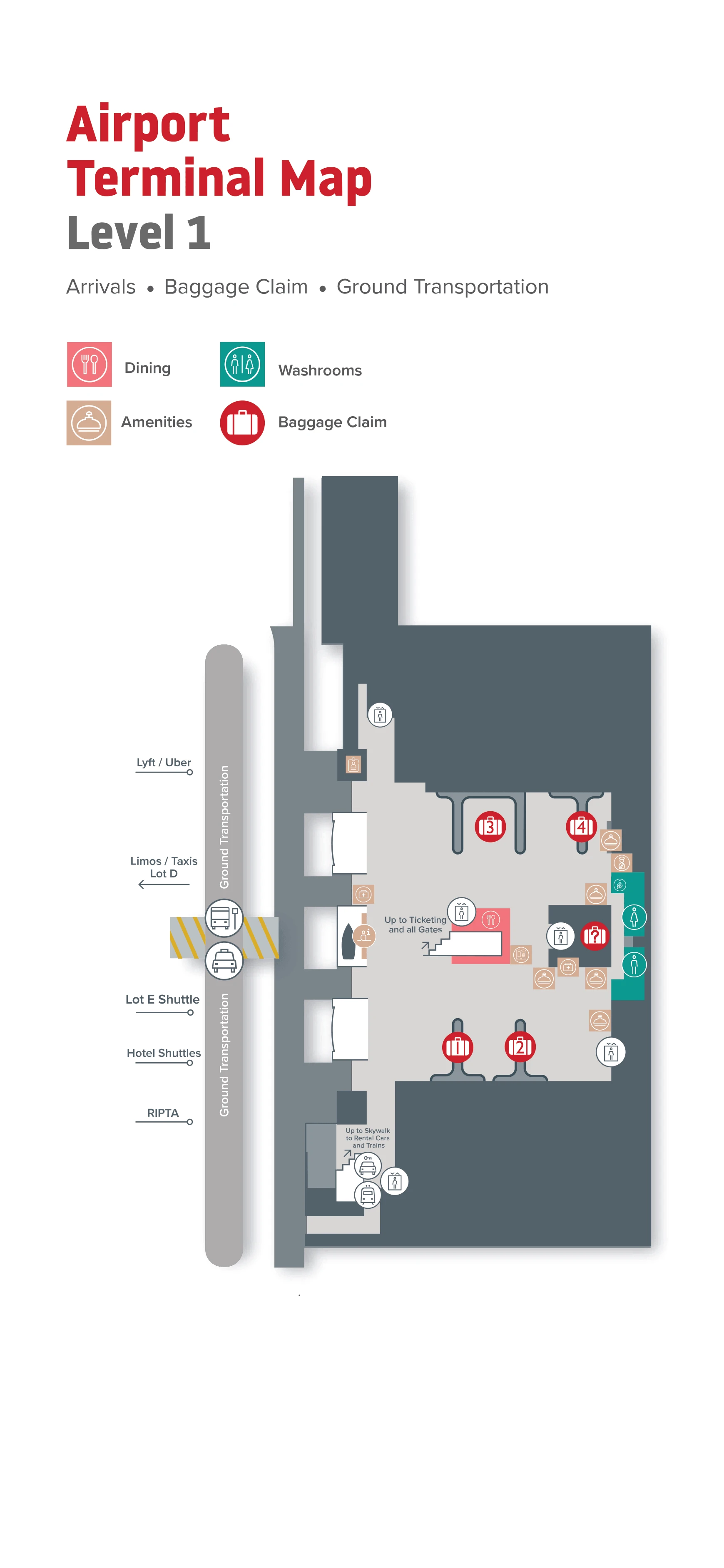
Theodore Francis Green State Airport Level 1 Arrivals Map 2026
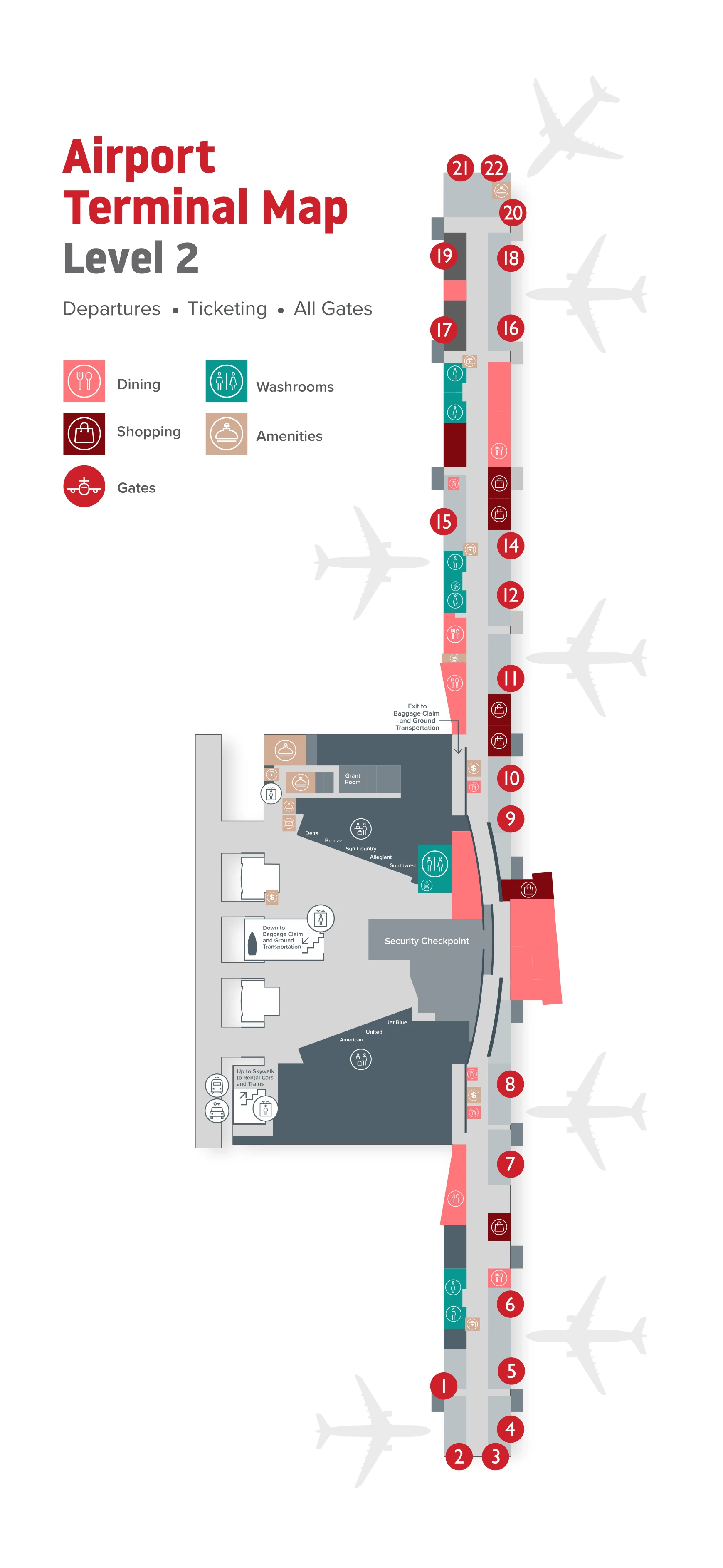
Theodore Francis Green State Airport Level 2 Departure Map 2026
2026 Theodore Francis Green State Airport Map Guide
What is the exact physical start point of the main TSA line during peak backups (the furthest point the queue reaches) in the departures hall?
The peak-backup TSA line can extend about 350 feet backward from the checkpoint into the Level 2 departures/ticketing hall, with the tail reaching past the main ticket-counter blocks toward the entrance vestibules. At full extension, the queue shifts out of its normal stanchion footprint in the central atrium and becomes a straight “spillback” line that runs between the ticket counters (Southwest/Delta/United counter area) and the atrium/food-court glazing.
| Condition | Furthest practical “tail” location | Nearby anchor point |
|---|---|---|
| Normal load | Central atrium stanchions | Between ticket-counter blocks and food-court atrium edge |
| Peak backup | ~350 ft spillback into ticketing hall | Past the ticket counters, approaching the entry vestibules where arriving curb traffic enters Level 2 |
What is the exact walking distance (in feet/meters) from the TSA exit to the farthest common gates (worst-case walk)?
The worst-case walk from the TSA exit to the farthest common gate is about 1,200 feet (≈366 meters) to Gate 22. This measurement starts at the TSA exit/revesting area by the central atrium food-court node, then commits left into the North Concourse and continues to the distal end of the pier.
| Segment | Anchor-to-anchor path | Distance |
|---|---|---|
| TSA exit → North Concourse entry | Revesting area by food court → hard-left into Gates 9–22 corridor | Included in total |
| Midpoint check | Pass Gate 9; continue past Narragansett Kitchen & Bar near Gate 16 | Included in total |
| End point | Julius Meinl coffee cart area → Gate 22 | Total ≈1,200 ft (≈366 m) |
Where is the exact Uber/Lyft pickup point (parking garage level + entry door) relative to the Skywalk exit?
Do NOT go to Parking Garage C for Uber/Lyft pickup at PVD. Uber and Lyft pickups are on Level 1 (Arrivals) at the Outer Arrivals Roadway, using the second curb island rather than the inner curb by the building. The correct pickup area is the outer roadway zone marked for rideshare (often indicated with purple curb/signage), not the Skywalk/garage side.
Use the arrivals curb pillars as your alignment tool: exit down to Level 1, walk to the outer island, then request pickup and message the driver your nearest pillar number from the red-numbered signs on the overhang supports. If you walk toward the Skywalk/InterLink connector looking for a garage-level pickup, you’ll trigger the classic wrong-place loop while your driver is geo-fenced to the arrivals curb.
Where is the exact Lot E (remote lot) shuttle boarding zone at the terminal (door number / curb lane / signage landmark)?
The Lot E shuttle boards on Level 1 (Arrivals) at the outer commercial curb on the center island across the first roadway, not at the inner curb closest to the terminal doors. This means you must cross the first crosswalk from the building-side curb to the second island where shuttles load and dwell.
| What to do | Exact boarding zone | “Wrong-place” constraint |
|---|---|---|
| Exit to Arrivals Level 1 | Go to the center island / outer commercial curb (shuttle zone) | Inner curb by the doors won’t be served by the Lot E shuttle |
| Find your landmark | Shuttle/loading signage on the outer island near the crosswalk | Waiting at the building-side lane leads to repeated shuttle pass-bys |
Where is the exact Skywalk entrance on the train-station side, and what is the measured Skywalk length to the terminal entrance doors?
The train-station-side Skywalk entrance is inside the InterLink facility at 700 Jefferson Boulevard, where rail passengers enter the enclosed connector that leads straight toward the terminal. The enclosed Skywalk length from InterLink to the terminal-side entrance is about 1,200 feet (≈366 meters), and the route includes moving sidewalks that reduce effort but not the underlying distance.
Plan the walk using hard anchors: enter InterLink, follow signs for the Skywalk/Terminal connector, step onto the enclosed walkway, and stay on the straight path until you reach the terminal-side entry doors at the end of the connector. If the moving sidewalks are stopped, treat the full 1,200 feet as an on-foot traverse with luggage.
Where is the exact rental car counter location (garage level + section) and the shortest indoor route from terminal to that counter?
The rental car counters are in the InterLink facility on Level 3, with vehicles picked up on Level 4. The shortest indoor route starts at the terminal, enters the enclosed Skywalk connector to InterLink, then goes up within InterLink to the Level 3 customer-service deck for contracts and keys.
Use the vertical rule to avoid a wrong-floor loop: the rail/bus/commuter functions sit on lower levels, so heading to Level 1 or 2 in InterLink won’t get you to a rental counter. Once you arrive via the Skywalk into InterLink, follow “Rental Car” wayfinding to the internal elevators/stairs, go directly to Level 3 for the counters, then continue to Level 4 only after you have paperwork/keys for vehicle pickup.
Where exactly are the numbered Arrivals pickup positions located (which curb segments correspond to which numbers)?
The numbered Arrivals pickup positions are the red-on-white pillar numbers mounted to the concrete support columns along the Level 1 Arrivals overhang. Those pillar numbers run in sequence along the linear curb frontage, and the “correct” pickup spot is simply the pillar you’re standing under when you step into the Arrivals roadway zone.
| Curb segment | Where you are physically | What the numbers represent |
|---|---|---|
| South end of Arrivals curb | Far end of the covered frontage, away from the central baggage-claim exits | Lowest pillar numbers in the sequence |
| Central Arrivals frontage | Main flow area outside the baggage-claim exits; easiest line-of-sight alignment for pickups | Middle pillar numbers; best default meetup zone |
| North end of Arrivals curb | Opposite end of the covered frontage from the south end | Highest pillar numbers in the sequence |
Use the pillar-number system as your handshake protocol: exit to Level 1, step fully to the curbside pickup area, find the nearest red pillar sign overhead, and text/call that number to your driver. If you say “outside baggage claim” without a pillar number, you’ll usually drift into a wrong-segment loop because the curb is one long continuous frontage.
Inside baggage claim, where is the exact Lost & Found / baggage service desk located relative to the carousels (side + landmark)?
The Lost & Found contact point in the baggage-claim hall is the central Information/Customer Service desk on Level 1, positioned in the public arrivals space adjacent to the carousel area rather than inside the secure exit corridor. Airline-specific baggage service offices line the rear wall of the baggage-claim hall (American, Delta, Southwest, JetBlue), so missing-bag problems route to those counters instead of the information desk.
Use the L’Artisan Café cluster as your navigation anchor: the café sits in the open baggage-claim floor near the sailboat display and the piano, and the Information/Customer Service function is in that same central public hall zone where meeters/greeters wait and you can see across to the carousel area. If the item was left at TSA, skip the hall desks entirely—TSA Lost & Found is handled separately.
Where exactly are the “security doors” / doorway threshold before descending to baggage claim (which corridor/transition)?
The “security doors” threshold is the one-way set of automated glass doors at the end of the arrivals exit lane on Level 1, where passengers finish descending from the concourse via escalators/stairs into the lower hall connector and then pass through into the public Baggage Claim Hall. These doors are the point of no return from secure-to-public space.
Use line-of-sight as your landmark: once you step through the glass doors, you’re immediately in the baggage claim mixing hall with direct visibility for meeters/greeters waiting inside. If you’re trying to coordinate a “meet me the moment I exit,” this doorway is the cleanest handshake zone—on the public side of the one-way glass doors, before you drift toward any carousel or curb exit.
Where is the downstairs cafe (baggage-claim level) relative to escalators and exits (to prevent backtracking)?
The downstairs café is L’Artisan Café inside the Level 1 Baggage Claim Hall, positioned in the open public floor area close to the arrivals exit flow from the one-way glass “security doors.” It sits near the most visible baggage-claim landmarks: the sailboat display and the piano used for live music.
To avoid backtracking, use this sequence: descend to Level 1, pass through the one-way glass doors into the public baggage hall, then orient toward the central open area—L’Artisan is the only arrivals-level café and is effectively centered between the secure exit stream and the carousel zone. If you walk outward toward the curb doors first, you’ll likely have to reverse direction back into the hall to reach it.