Stockholm Arlanda Airport Map (Most Up-To-Date)
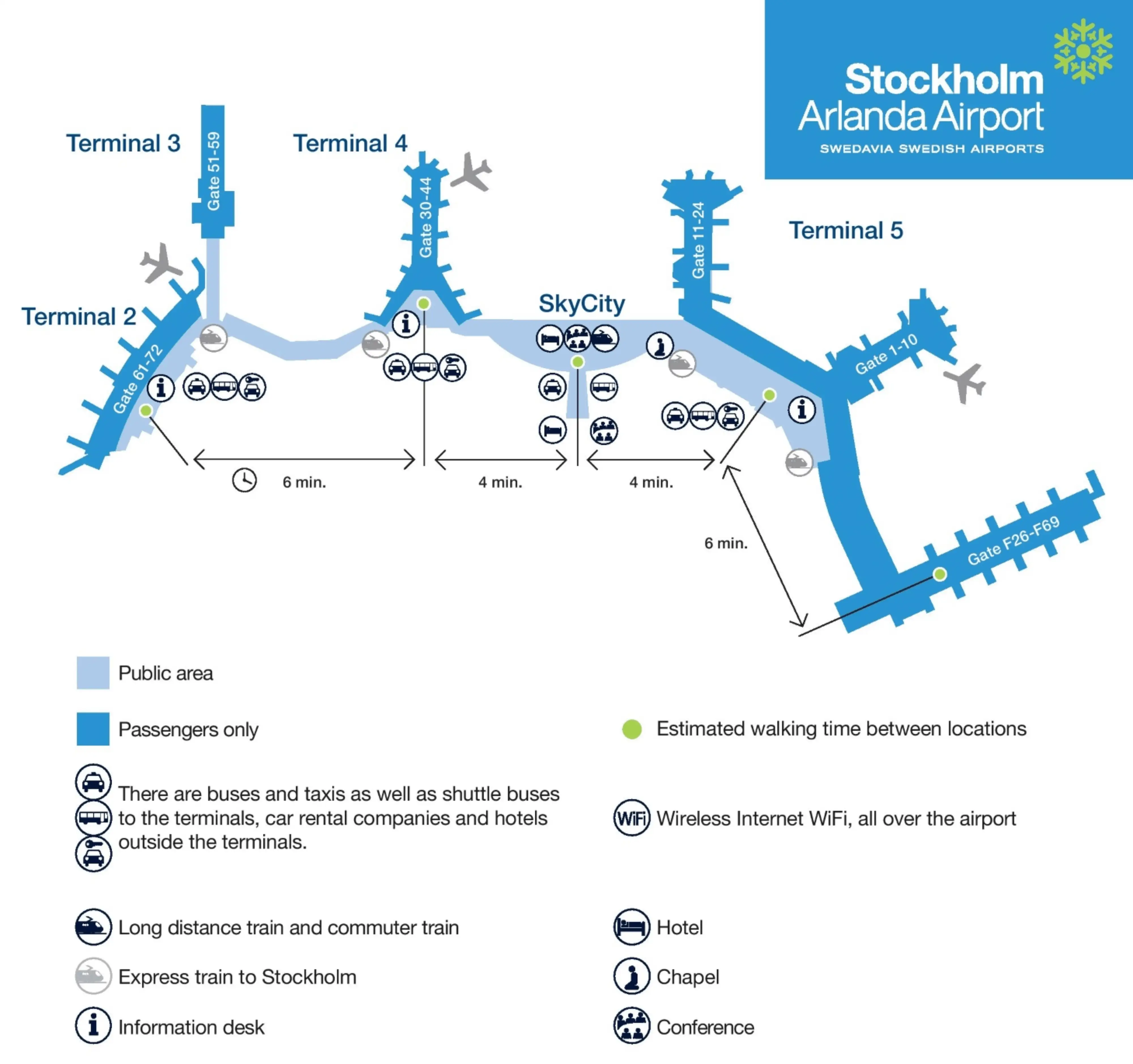
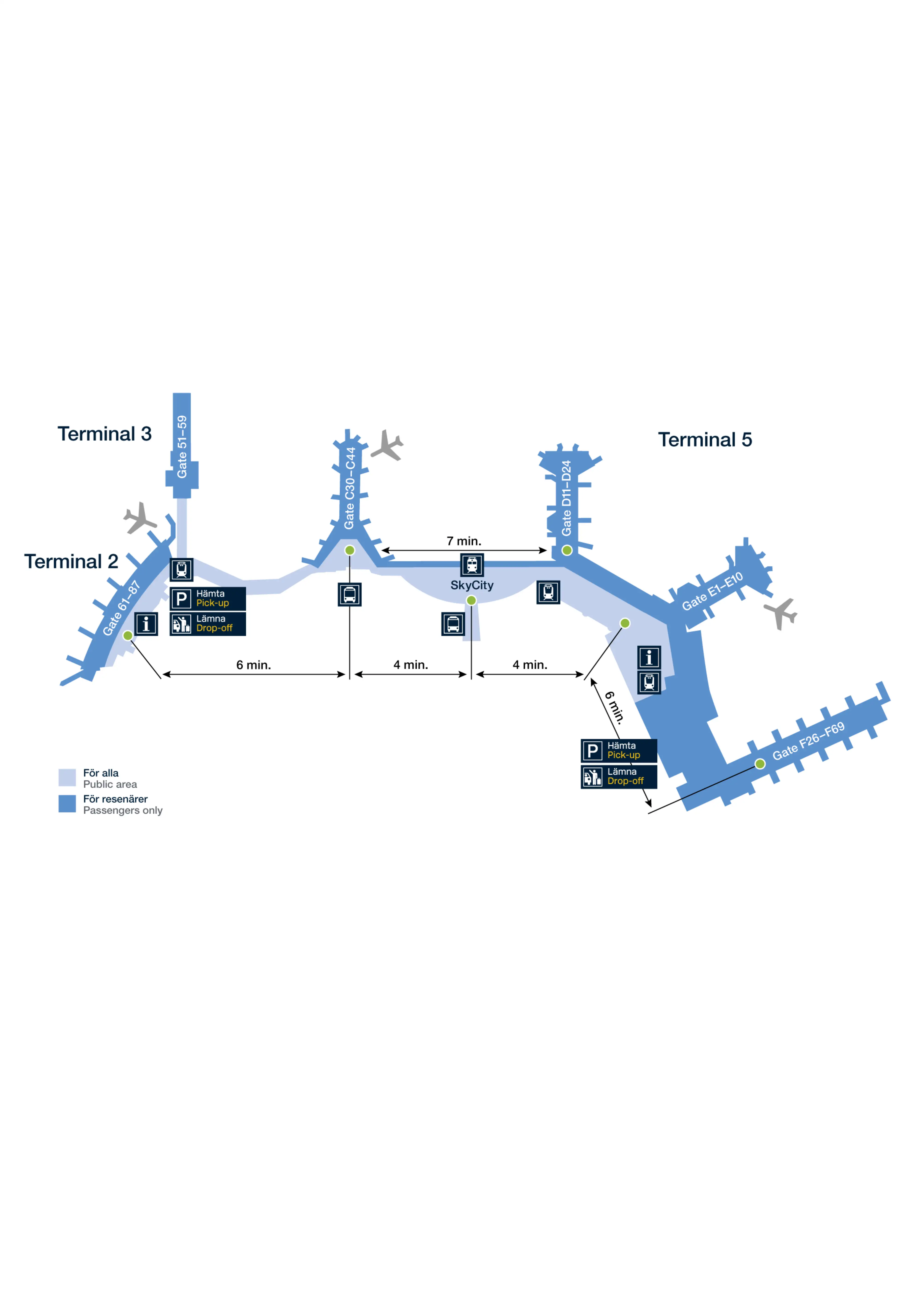
Stockholm-Arlanda Airport (ARN) now reads like a stretched, hybrid “single-terminal” spine: Terminal 5 is the main distribution core, linked airside to the former Terminal 4 pier (Gate Area C) by a long glazed connector, while Terminal 2 sits apart as an airside “island” reached by bus. Most passenger decision-making happens around the Terminal 5 Marketplace and the pier splits (D/E/F) within Stockholm’s main aviation hub.
Map Table
| Terminal | Key Airlines | Primary Function | Transfer Mode |
|---|---|---|---|
| Terminal 5 / Gate Areas D–E | SAS focus | Schengen departures | walk, connector |
| Terminal 5 / Gate Area F | long-haul mix | non-Schengen departures | walk, passport control |
| Gate Area C (ex-Terminal 4) | domestic feed | satellite gates | walk, travelators |
| Terminal 2 | alliance mix | separate concourse | on-demand bus |
| Terminal 3 | regional mix | domestic / regional processing | walk via SkyCity |
Stockholm Arlanda Airport Map Strategy
- Treat ARN as three zones: Terminal 2, Terminal 5 (Schengen), Terminal 5 (Non-Schengen F). The bus and passport boundary are the two “time-certainty breakers.”
- Lock your critical path first: confirm your pier (D/E/F) or Gate Area C before moving, then aim for the nearest named connector node (T11 for C-connection, F5 for the F-pier root).
- Budget distance, not vibes: the 5F security exit to Gate Area C is roughly 600–650 m gate-to-corridor, and “F-gates” signage can hide an extra long last-mile to the far tip.
- If you’re going to Pier F, assume passport control sits at the neck of the pier and can trap you—don’t leave it for last-minute gate checks, and don’t plan lounge time “after” it.
2026 Stockholm Arlanda Airport Map + Printable PDF
Terminal 5 remains the operational “center of gravity” in 2026, with the 5F checkpoint feeding directly into the Marketplace distribution node for D/E/F. Gate Area C (ex-Terminal 4) stays airside-connected via the long elevated walkway, while Terminal 2 still requires an airside bus transfer with summon-button behavior at key nodes. Plan your print map around labels like T11, F5, and Sky City.
2026 Stockholm Arlanda Airport Map Guide
What is the exact indoor walking route (turn-by-turn landmarks) from Terminal 5 security exit to the closest Terminal 4 gate corridor, and what is the walking distance in meters?
Walking is about 600–650 meters from the Terminal 5 security exit at Checkpoint 5F to the start of the closest Gate Area C corridor (near Gate C30).
Exit Checkpoint 5F into the duty-free walkthrough and follow the forced serpentine path to the duty-free exit. Continue straight into the Verandan Marketplace, keeping the large glazed airfield-facing side to your right as you move south through the atrium. Pass the Pier D entrance (Gates 11–24) on your right and keep going until you see overhead signs for “Gates C30–C44 / Terminal 4.” Turn into the narrower connector entrance by Transfer Gate T11, then stay on the elevated glazed walkway with moving walkways until it drops you into the old Terminal 4 airside entry area; the Gate C30 corridor begins just ahead.
Where is the Terminal 2 ↔ Terminal 5 airside transfer bus pickup point in Terminal 2 (exact gate/door label) on the map?
The Terminal 2 ↔ Terminal 5 airside transfer bus pickup point in Terminal 2 is Gate 61C.
Gate 61C is a dedicated bus gate rather than a normal jet-bridge gate, positioned on the lower level beneath the main Terminal 2 departures lounge. If you arrive airside in Terminal 2, route yourself to the Gate 61 area, then go down one level (stairs/elevator) to the 61C bus-gate zone. The operational failure mode is waiting in the wrong place: the summon hardware is at 61C, so you want to be physically at the 61C door/gate label before you start budgeting the bus wait.
Where is the button/summon point for the on-demand airside bus in Terminal 5 (exact gate-area label) shown on the terminal map?
The on-demand airside bus summon points in Terminal 5 are labeled Transfer Gate T11 and Gate F5 on the terminal map.
Transfer Gate T11 sits in the connecting corridor between Gate Area C (ex-Terminal 4) and the main Terminal 5 spine, acting as the intercept point as you come off the glazed connector into the Marketplace side. Gate F5 is at the root of Pier F on the Terminal 5 side, near the Schengen-zone entrance into the F-pier. If you’re standing in the Marketplace distribution area, T11 is the nearer “C-connector” node, while F5 is the “F-pier root” node.
What is the mapped walking distance from Terminal 5 Marketplace (between D and F) to the F-gates corner area, measured in meters?
The mapped walking distance is about 470 meters from the Terminal 5 Marketplace node (between the D and F pier entrances) to the F-gates corner area at the root of Pier F.
From the Marketplace “distribution” space, follow the overhead gantry signs for “Gates F26–F69” toward the Pier F entrance corridor, staying on the main concourse line rather than drifting into the Pier D mouth. The “corner” you’re aiming for is the Pier F neck area where the flow tightens and the passport-control plaza begins for non-Schengen movements. ARN’s wayfinding screens that show “6 min” to the F-gates area convert to roughly 468 m at a standard walking speed, which rounds cleanly to ~470 m on a map-distance basis.
On the map, what is the shortest path from arrivals in Terminal 5 to passport control for non-Schengen departures, and what are the two nearest landmark waypoints along that path?
Passport control for non-Schengen departures sits at the neck of Pier F, so the shortest path is a direct line from the Terminal 5 Marketplace node into the Pier F approach corridor.
Start from the Terminal 5 airside “town square” just after the duty-free exit and orient toward the overhead signage gantry for Pier F. Walk straight toward the “Gates F26–F69” direction until the concourse funnels into the Pier F entry, where the passport-control plaza begins. The two closest landmark waypoints on that path are the Duty-Free Exit / Marketplace Entrance and the Pier F signage gantry that splits “Gates F26–F69” away from the local F-gate numbering.
Where are the three security checkpoint entrances that can feed Terminal 5 gate areas, and which checkpoint is closest (meters) to the D/E/F gate split?
Checkpoint 5F is the closest security entrance to the D/E/F gate split, with under 100 meters from its exit into the Marketplace to the pier decision point.
| Security entrance | Status / role on the map | Closest to D/E/F split |
|---|---|---|
| Checkpoint 5F | primary Terminal 5 security into Marketplace | yes, <100 m |
| Checkpoint 5D | legacy checkpoint near older pier roots | no |
| Terminal 4 security | decommissioned after T4/T5 integration | no |
What is the exact mapped distance from the Terminal 5 central spine to the furthest common F gate area, and does the path require any level changes shown on the map?
The mapped distance is about 750–800 meters from the Terminal 5 central spine (Marketplace distribution node) to the furthest common Pier F gate area, and the route can include level changes at the far end of Pier F.
The core walk is Marketplace to the Pier F root (about 470 m), then continuing down the Pier F extension to the far-gate corner (roughly another 280–330 m depending on which “furthest common” gate cluster you’re targeting). The map logic stays mostly on departures level through the spine, but Pier F’s non-Schengen segregation and widebody gate layouts commonly introduce vertical circulation (escalators/stairs/elevators) near the far holding rooms and jet-bridge approaches, so don’t assume a perfectly flat, single-level sprint once you’re deep in F.
If a flight’s gate changes to an F gate last-minute, what is the fastest mapped route from the D-pier side to the F-pier side, and what is the minimum walk time implied by distance?
Passport control at the neck of Pier F can become the overriding delay, because you must pass it to reach non-Schengen F gates and there’s no airside bypass.
From the D-pier corridor, exit back into the Marketplace distribution area, then cut laterally across the Marketplace toward the Pier F entrance following the “Gates F…” gantry. Enter Pier F at the root and continue to passport control at the pier neck; after clearing, walk down the F extension toward your assigned gate. The physical distance for a D-to-deep-F move is roughly 700 meters end-to-end, which implies about 6 minutes at a fast 2.0 m/s pace, but any queue at passport control immediately turns this into a 20–30+ minute event.
On the map, where exactly is Transfer Gate T11, and what is the distance from T11 to the T5 bus stop (F5)?
Transfer Gate T11 is in the connector corridor between Gate Area C (ex-Terminal 4) and the main Terminal 5 spine, right at the threshold where the glazed walkway feeds into the Terminal 5 Marketplace side.
| Point | Exact map placement | Distance |
|---|---|---|
| Transfer Gate T11 | C-connector corridor into T5 spine | — |
| Gate F5 bus stop | root of Pier F (Schengen side) | ~350 m from T11 |
Where is the landside connection corridor between Terminal 4 and Terminal 5 (Sky City/connecting area) on the map, and what is the shortest indoor path from that corridor to Terminal 5 check-in/bag drop?
The landside connection corridor is SkyCity, the indoor atrium linking Terminal 4 and Terminal 5 above Arlanda Central Station.
From the Terminal 4 side, enter SkyCity on the departures level and stay on the same level as you move south toward Terminal 5 (don’t drop down into the train/arrivals levels unless you’re aiming for rail). Continue through the SkyCity retail spine until you reach the Terminal 5 headhouse opening into the check-in hall; from that threshold, the shortest indoor line to bag drop is straight into the Terminal 5 check-in hall toward the central counter belts. The typical indoor distance from the T4–SkyCity boundary to the center of T5 check-in is about 400–500 meters.
On the map, what are the alternative entrances into the Terminal 5 departures/check-in hall, and which entrance minimizes backtracking if the bag-drop queue is blocking the main approach?
The SkyCity (south) entrance minimizes backtracking when the main curbside approach is blocked by a bag-drop queue.
Terminal 5’s departures/check-in hall can be entered from multiple curbside door sets along the drop-off frontage, from the SkyCity connection at the south end of the hall, and from the Arlanda North station elevator/escalator bank that rises directly into the hall near the center/north. If the central area is gridlocked, using SkyCity lets you “flank” the congestion by entering at the south end and walking up the hall internally toward kiosks or less-blocked counter belts instead of fighting the crowd at the main curbside doors.
Where is the Arlanda Express platform access path relative to the Terminal 5/Sky City core, and what is the shortest indoor walking route from the train arrival point to Terminal 5 departures?
Arlanda Express access for Terminal 5 is via Arlanda North, which sits directly beneath Terminal 5 as the vertical injection point into departures.
Arrive at Arlanda North (not Arlanda South), then follow signs to the dedicated Terminal 5 departures lifts/escalators. Take the elevator or escalator up to Level 3, where you emerge directly inside the Terminal 5 check-in/departures hall near the center/north side. The shortest indoor walk from the elevator doors to the nearest check-in counters is under 50 meters, making this the fastest rail-to-departures path in the ARN complex.
Archive Stockholm Arlanda Airport Map
Below are all historical map versions for Stockholm Arlanda Airport. Each year includes the official map available for that period, presented as both WebP and PDF.
2022 Stockholm Arlanda Airport Map