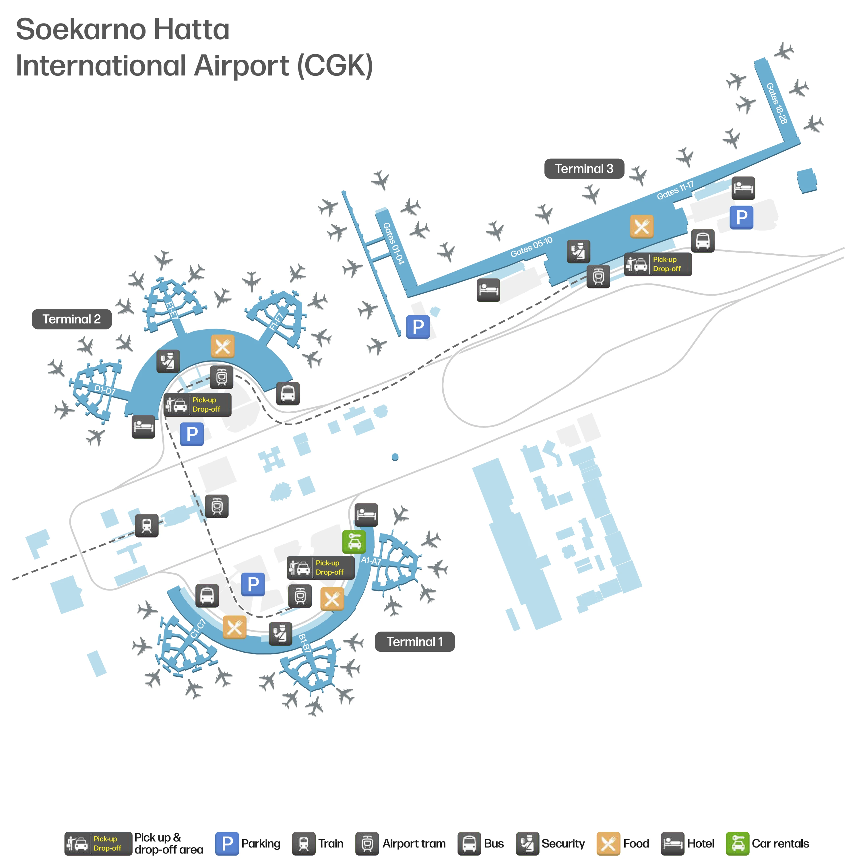
Soekarno Hatta International Airport Map (Most Up-To-Date)
Soekarno-Hatta International Airport spreads as a multi-terminal campus: the older, curved Terminal 1 and Terminal 2 clusters sit as separate “pods,” while Terminal 3 runs as a long, linear spine with very long end-to-end walks. Within Jakarta’s main airport complex, movement is fundamentally landside-first (roads, curb zones, parking structures), so terminal changes and self-transfers depend on finding the external Kalayang Skytrain or shuttle bays quickly rather than relying on seamless indoor links.
Map Table
| Terminal | Key Airlines | Primary Function | Transfer Mode |
|---|---|---|---|
| Terminal 3 | Garuda Indonesia; many international carriers | Main international; major domestic | Kalayang Skytrain; shuttle bus; curbside walk |
| Terminal 2 (2D/2E/2F) | Mix of domestic/international (varies) | Legacy processing; multi-sector ops | Kalayang Skytrain via “White Bridge”; shuttle bus |
| Terminal 1 (1A/1B/1C) | Primarily domestic (varies) | Legacy domestic pods | Shuttle bus; Kalayang via connecting stops |
| Rail Station (Stasiun Kereta Bandara) | Airport Rail Link | City rail access node | Kalayang Skytrain transfer |
Soekarno-Hatta International Airport Map Strategy
- Treat every self-transfer as a landside mission: plan for immigration → baggage → customs QR scan → re-check and bag drop → terminal change (if needed) → new security → long pier walk.
- Do not follow the crowd straight out after customs unless you’re truly exiting; immediately hunt for “Transfer” / “Domestic Transfer” / “Kalayang” so you don’t get pushed into curbside loops.
- Use the map to lock onto the exact Skytrain access geometry (external curb walk → detached elevator or escalator tower → bridge → platform) and budget for weather exposure plus headway waits.
- Assume long gate walks inside Terminal 3; map your security-to-gate distance early, especially for Gate 20+ bus or remote zones, and move with a time buffer rather than “arrive at security on time.”
2026 Soekarno Hatta International Airport Map + Printable PDF
2026 navigation at Soekarno-Hatta International Airport still hinges on finding the correct “handoff” points fast: where immigration and visa-on-arrival queues begin, which customs exit doors spill you into arrivals, and where transfer-only escalators or Skytrain access actually sit relative to curb doors. The printable map is most useful when you’re self-transferring or switching terminals, because the longest delays come from missed turns that force you outside, back through crowds, and into the wrong security line.
2026 Soekarno Hatta International Airport Map Guide
What is the exact indoor route from Terminal 3 International Arrivals to the Skytrain (“kalayang”) access point (including the specific corridor/landmark turns)?
The route requires leaving the terminal and using the detached curbside access tower, because the Skytrain station is outside the Terminal 3 building envelope. From the international arrivals flow, the critical move is to avoid being carried straight into the central taxi/touts zone and instead exit toward the curb direction that lines up with the Skytrain signage.
From the public arrivals hall after customs, follow signs for “Kalayang/Skytrain” toward the main curbside exits, then leave the building to the covered curb pavement and turn into the Skytrain access zone with the standalone elevator/escalator tower. Take the escalator/elevator up to the elevated pedestrian bridge level, cross the bridge into the Skytrain station structure, and continue to the platform. The best “confirmation landmark” is the transition from terminal doors to the separate vertical-transport tower before you ever see the platform.
Where is the Terminal 2 Skytrain access bridge located relative to the T2D/T2E/T2F arrivals arc (exact “center point” landmark used to find it)?
The Terminal 2 Skytrain access bridge sits opposite Sub-Terminal 2E, the middle “center point” of the T2D–T2E–T2F arc. The fastest way to orient is to find the Skytrain station island and the distinctive white pedestrian bridge that crosses the roadway into the terminal.
After you get off at the Terminal 2 Skytrain station, head toward the “Beautiful White Bridge” spanning the arrivals/departures road. Crossing it drops you into Terminal 2’s Level 2 public concourse, positioned between the inner-ring departures hall and the shopping arcade corridor. From that midpoint (2E), walk along the internal corridor toward 2D or 2F; the symmetry is the trap, so use “2E” and the white bridge as your fixed center reference.
What is the exact walking distance (meters) from the Terminal 3 Skytrain drop-off point to the primary domestic check-in hall entrance?
The walking distance is approximately 100–150 meters from the Terminal 3 Skytrain platform edge to the first check-in hall entrance threshold. The distance covers the elevated platform exit, the connecting bridge, and the terminal-side entry point before you fan into the main departures/check-in volume.
After arriving on the Skytrain at Terminal 3, follow the pedestrian bridge from the station straight toward the terminal building; the “distance reset” landmark is the moment you leave the open-air station canopy and enter the enclosed bridge segment. The bridge feeds into the departures/mezzanine side of Terminal 3, and the check-in hall entrance is the first major interior opening into the large public check-in space. If your airline is on the domestic islands deeper in the hall, expect an additional 200–400 meters beyond the entrance depending on counter island location.
Where does the Terminal 3 immigration queue physically begin (the first choke corridor/threshold passengers stack into), relative to arrivals flow?
The Terminal 3 immigration queue physically begins at the immigration hall entry turn where the arrivals corridor meets the hall at a perpendicular 90-degree turn. The first “stacking” happens before passengers can see the full spread of counters, so the queue forms in the threshold corridor rather than neatly inside the hall.
From the arrival pier flow coming off Gates 1–10, walk toward the central processing core and watch for the immigration hall opening; the choke point is the moment the main arrivals stream is forced to pivot into the hall. If you arrive from the far end (Gates 1–4), the long walk to the core (often 10–15 minutes) hides the queue until you reach that corner. Use the hall entrance itself as the landmark: once you make the 90-degree turn, you’re in the queue geometry.
Where are the Visa-on-Arrival counters positioned inside the Terminal 3 immigration hall relative to e-gates/manual lanes (left/right/behind which landmark)?
The Visa-on-Arrival counters sit on the right-hand side of the arrivals concourse just before the turn into the immigration hall, with the e-gates positioned more centrally and to the left inside the immigration processing area. The key tell is the right-side payment queue forming before you commit to the immigration hall entry.
Coming down the international arrivals corridor toward immigration, stay left if you do not need VoA, because the VoA line forms on the right and can spill back into the main passage. The landmark is the immigration hall entrance corner: VoA is immediately before that threshold on the right, while the hall beyond opens into manual counters across the width and e-gates clustered centrally/left. If you find yourself already inside the hall and deep in a single-file queue, you’ve likely missed the VoA payment position.
What is the exact location of the post-customs re-check/bag drop counters for international→domestic self-transfer in Terminal 3 (which exit/door zone)?
The re-check point is the Domestic Transfer Desk area on the ground-floor public arrivals side immediately after you exit customs, before you get funneled out toward the main curb doors. Missing it and walking straight toward Doors 1–5 is the common failure mode that forces a full landside loop.
After the customs QR scan and inspection funnel, you exit through sliding glass doors into the public arrivals hall; stop and scan for “Domestic Transfer” / “Transfer Desk” signage before following the crowd to the curb. The re-check/bag acceptance function sits at that ground-floor transfer desk cluster, adjacent to the dedicated transfer escalators/elevators up to departures. If that desk cannot accept your baggage (airline/through-tag limitations), the fallback bag drop is upstairs in the main check-in hall at the domestic islands, commonly directed to Check-in Island F (and sometimes Island E) on Level 2.
What is the exact route from Terminal 3 customs exit to the vertical path (escalator/elevator) that leads to the domestic departures level for onward flights?
The route is the immediate “stay inside” turn from the customs sliding doors to the transfer desk zone, where the dedicated transfer escalators and elevators lift you straight to Level 2 departures. The dealbreaker is exiting to the curb first, because that dumps you into the public departures re-entry flow and longer security lines.
After you clear customs QR scanning and walk through the sliding glass doors into the public arrivals hall, stop before the central doors feeding taxis and greeters. Follow the “Domestic Transfer/Transfer Desk” direction within the arrivals hall circulation lane, then aim for the escalator/elevator bank adjacent to the transfer desk area rather than the curbside door banks. Ride up to Level 2 and you’ll surface at the transfer-side security position, not the main public security hall.
What is the walking time and distance from Terminal 3 domestic security screening to gates in the “20+” gate range (measured along the shortest viable passenger path)?
Walking takes about 15–25 minutes and can exceed 1 kilometer from Terminal 3 domestic security to the Gate 20+ range because those gates often function as remote/bus-gate zones beyond the main contact pier. The risk is structural: there is no airside people mover, so the only way is the long pier path plus any required level change into the bus lounge area.
From the domestic transfer-side security exit into the domestic concourse, use the central retail atrium as your first anchor, then commit to the pier direction for higher gate numbers. Typical metrics along the shortest viable passenger path are: ~5 minutes (~300 m) to near Gate 11, ~12–15 minutes (~800 m–1 km) to the end of the main contact-gate pier (around Gate 17), and then additional walking plus a possible descent to reach the Gate 20+ remote/bus lounge area. If travelators are down or crowded, the upper end of the time range is the realistic planning number.
Where is the domestic security screening point located for passengers coming up from international arrivals (exact checkpoint position relative to the main departures concourse)?
The domestic security screening point is at Level 2 at the top of the dedicated transfer escalator/elevator from the Terminal 3 arrivals hall, positioned before you merge into the main public departures concourse. This checkpoint is intentionally separate from the standard landside security lines used by walk-in departing passengers.
From the customs exit, the route that stays inside leads to the transfer desk zone and then up the transfer escalators/elevators; at the top landing on Level 2, the checkpoint sits immediately in that transfer arrival corridor so you clear screening before entering the domestic airside circulation. The nearest fixed landmark is the transfer-side vertical-transport landing itself: if you can still see the escalator bank behind you, you’re at the correct security interface, and you should emerge into the domestic concourse near the central retail/atrium zone rather than at the far ends of the check-in hall.
Where is the Terminal 3 transfer desk located airside (exact hall/zone), and what is the nearest fixed landmark (e.g., gate cluster, lounge, escalator bank)?
The Terminal 3 airside transfer desk is the international transit counter located before immigration in the international arrivals-to-immigration approach zone, not in the public arrivals hall. The nearest reliable landmark is the immigration hall threshold area, because the transit counter sits in the same pre-immigration processing pocket where passengers are sorted before committing to immigration.
After you leave the arriving gate corridors and move toward the central processing core, stay alert for “Transit/Transfer” signage before the 90-degree turn into the immigration hall queue. The desk is positioned in that pre-immigration concourse segment, which functions as the last decision point between “transfer airside” and “enter Indonesia via immigration.” If you reach the visa-on-arrival payment queue spillover or you’re already stacking into the immigration hall entry turn, you’ve gone too far past the transfer decision zone.
Where are the free inter-terminal shuttle bus pickup bays located at Terminal 1 (exact curb level and bay identifiers), relative to arrivals exits?
The inter-terminal shuttle pickup at Terminal 1 is at the arrivals curbside level at the parking-area canopy islands serving Terminal 1B and Terminal 1C. The practical landmark is the covered canopy area across the arrivals lane, because the bays are not directly at the terminal doors and typically require crossing the arrivals roadway.
After exiting Terminal 1 arrivals, look for signage pointing to shuttle or inter-terminal buses and aim for the parking canopy zones labeled for Terminal 1B or Terminal 1C rather than waiting in the main car/taxi curb stream. The geometry is fragmented across 1A/1B/1C, so the canopy islands act as the “collection node” that consolidates shuttle loading. If you are standing directly in front of the terminal doors in the taxi/private car lane, you are usually one step short—move toward the covered canopy islands where buses can berth safely.
Where is the inter-terminal shuttle bus pickup point at Terminal 3 (exact curb/door zone), and what is the shortest indoor path to reach it from arrivals?
The Terminal 3 inter-terminal shuttle pickup is in the “Terminal 3 Secondary” curb area at the far ends of the arrivals curb, not in the central doors where taxis and private cars dominate. The shortest indoor path is the straight-line walk through the public arrivals hall to the end-cap exits, then out to the curb zone where bus movements are separated from the main pickup lanes.
After customs, stay in the arrivals hall and do not commit to the central Doors 2–3 taxi zone unless you’re taking a taxi. Walk along the interior edge of the arrivals hall toward an extreme exit—either near the Gate 1 end or past the Door 5 side—following any “Bus/Shuttle/Secondary” indications. Once outside, continue along the curb to the designated secondary loading stretch, which is set away from the densest meet-and-greet area. If you’re surrounded by taxi kiosks and queue screens, you’re in the wrong (central) curb segment—keep moving toward the curb ends.
What is the exact indoor route from Terminal 3 arrivals to the Airport Rail Link station connection (including which Skytrain stop or walkway segment is used)?
The route requires using the Skytrain because the Airport Rail Link station is not walk-connected to Terminal 3. The connection sequence is Terminal 3 arrivals to the curbside Skytrain station access, then a Skytrain ride to the stop serving the rail complex labeled Stasiun Kereta Bandara.
From Terminal 3 arrivals after customs, follow “Kalayang/Skytrain” guidance to the curbside exit and walk outside to the detached elevator/escalator tower that serves the elevated Skytrain station. Ride up to the bridge level, cross the pedestrian bridge into the Skytrain station, and board the Skytrain toward the integrated building/rail node. Get off at the Skytrain stop for Stasiun Kereta Bandara, then follow station wayfinding into the Airport Rail Link concourse—this is the handoff point between the Skytrain platform and the rail station building. The main time penalty to plan for is Skytrain headway wait plus the external station access walk.
Where is the Grab/GoCar pickup zone at Terminal 3 located (exact level + door zone), and what is the shortest signed path from arrivals to that pickup?
The Grab/GoCar pickup zone is on the ground floor inside the multi-story parking garage, not on the main arrivals curb, and international-arrivals routing is typically anchored off the Gate 1 end of the Terminal 3 arrivals hall. The shortest signed path uses the curbside walk to a zebra crossing into the parking structure, then continues to the designated “Grab Lounge/Pickup Point” area.
From international arrivals after customs, walk inside the public arrivals hall toward the Gate 1 (west) end rather than stopping at the central taxi doors. Exit at the Gate 1 side, turn left along the curb past the telecom/commercial booths, then use the zebra crossing to cross the roadway into the multi-story car park. Inside the garage at ground level, follow the Grab signage/totems to the marked pickup point. If you are standing at Doors 2–3 with taxi queue kiosks, you are in the central curb zone and need to reposition toward the Gate 1 end to reach the ride-hail routing.