Seattle Tacoma International Airport Central Terminal Map (Most Up-To-Date)
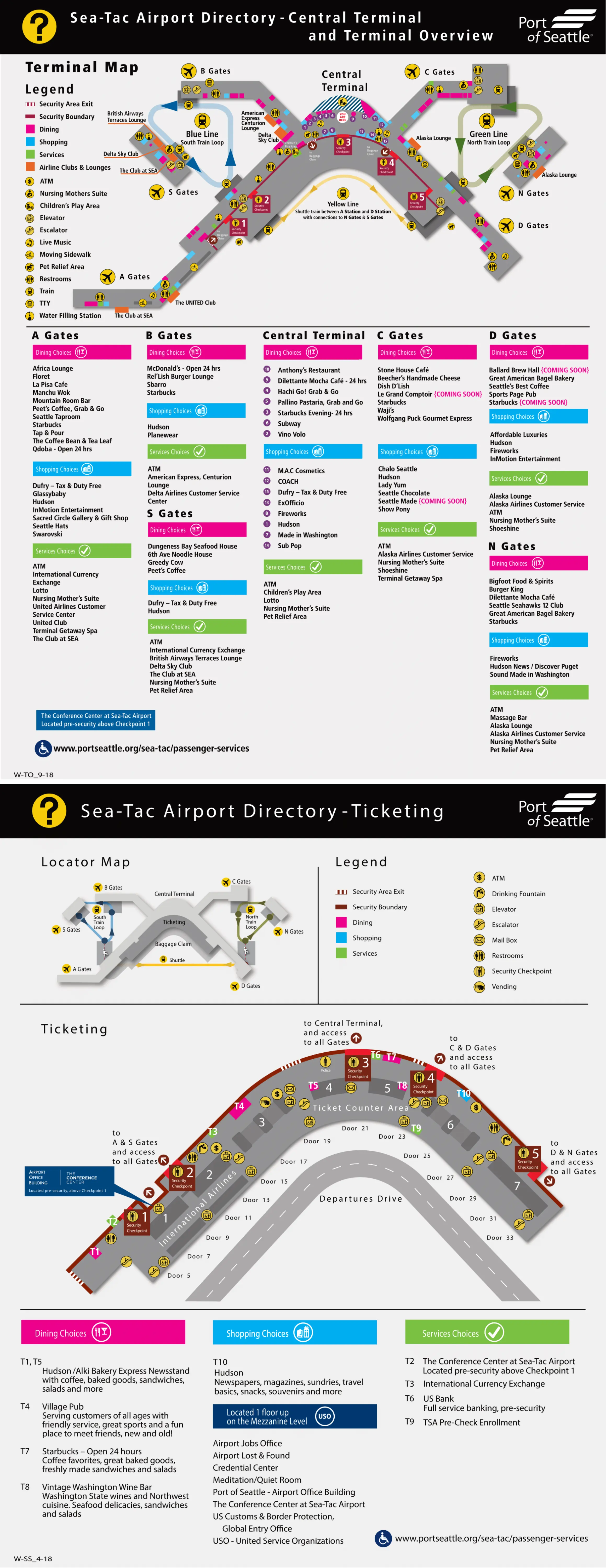
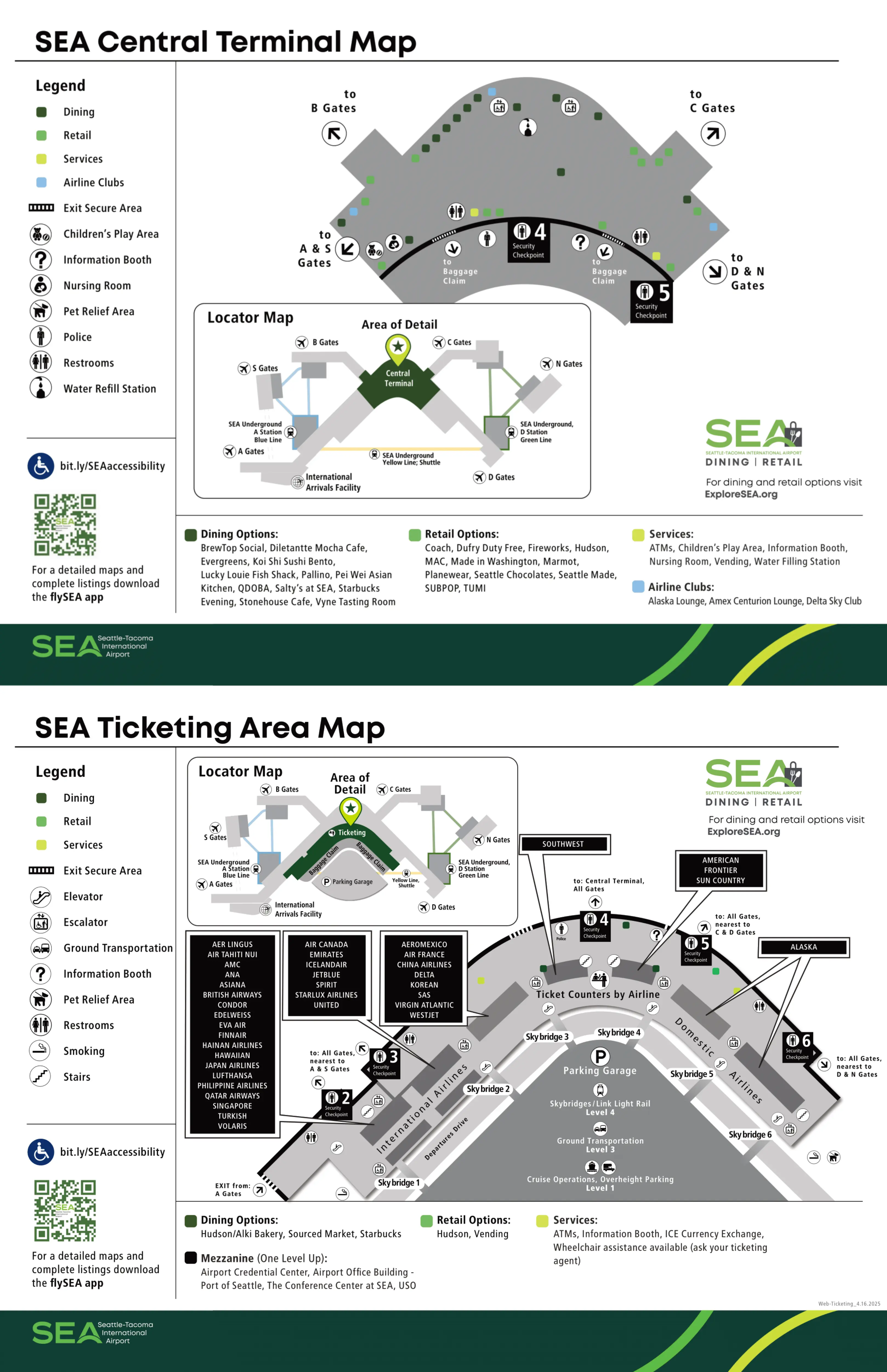
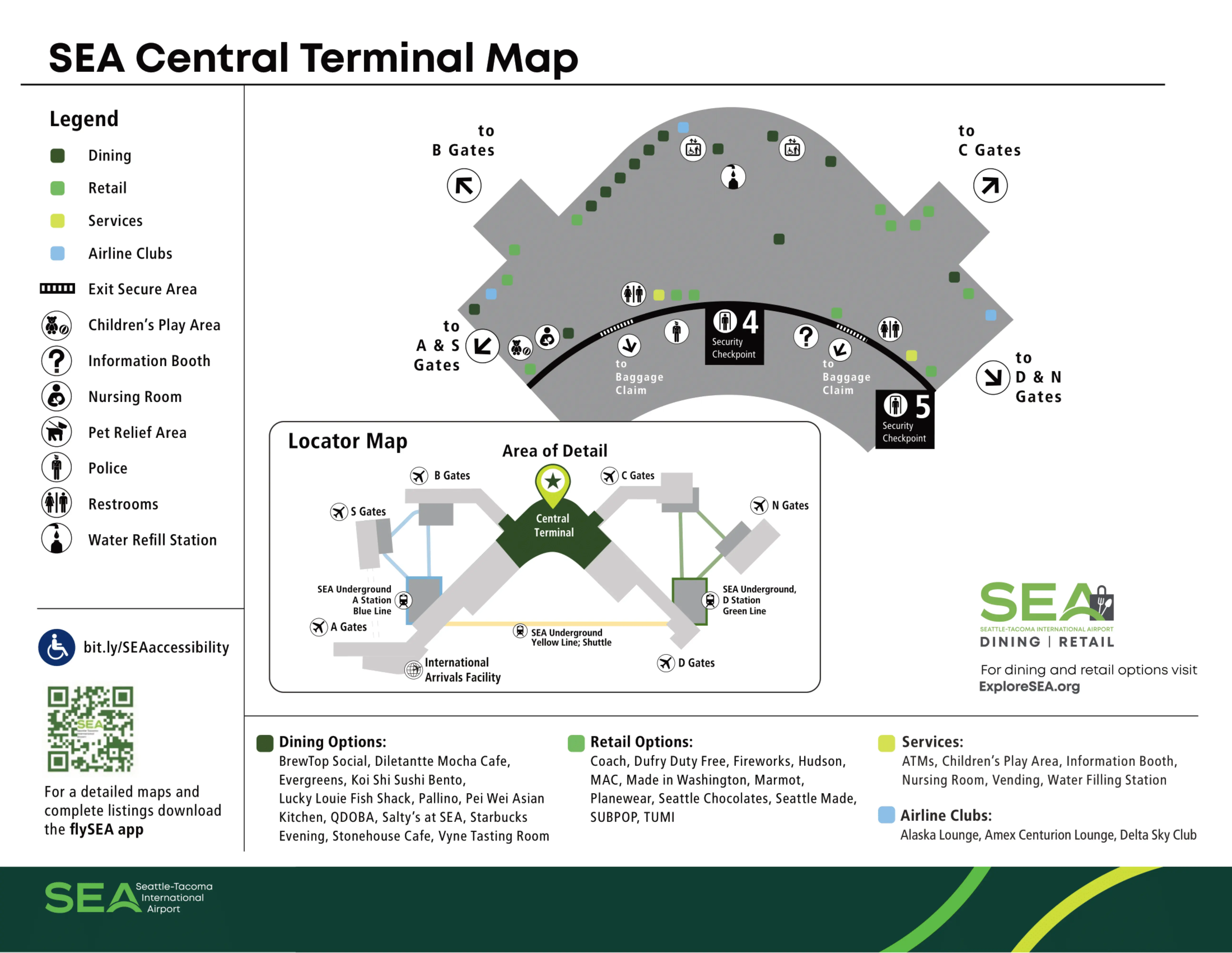
SEA Central Terminal is a wide, X-shaped airside nucleus with an open “food court window wall” core that feeds two radials: A/B/S to the south and C/D/N to the north. Within Seattle’s main airport complex, this space is the choke-point where checkpoint exits, construction pinch points, and SEA Underground access all converge. Your practical orientation anchors are the train drops at Gate A3 (south), Gate D2 (north), and Gate C11 (mid-C).
Map Table
| Zone | Connection | Walk Time |
|---|---|---|
| Central Terminal food court core | A throat (south) / D throat (north) | 2–3 min to A3 |
| Checkpoint 1 airside landing | A3 train descent / Yellow Line to D | 1–2 min to A Station |
| Checkpoint 6 airside exit | D2 train descent / Green Line to N | < 1 min to D2 |
| C Concourse mid-point (C11) | Green Line C Station / fork for C16 vs D | 6–8 min to C16 |
Seattle Tacoma International Airport Central Terminal Map Strategy
- Treat checkpoint choice as a failover plan: default to the checkpoint closest to your target train drop (A3 for south, D2 for north), and assume a closure/reroute can force a longer cross-terminal traverse.
- Use immutable landmark anchors instead of checkpoint numbers: Gate A3 (A/B/S trains), Gate D2 (D/C/N trains), Gate C11 (C Station + the C16 backtrack fork).
- Don’t bet a connection on “just walking to the satellites”: North Satellite and South Satellite access is train-dependent; a disruption turns into a real delay, not a detour.
- Expect the Central Terminal core to be the crowding choke-point: bypass it with Checkpoint 1 when eligible, and rely on overhead digital signs at the C/D junction where construction walls compress the flow.
2026 Seattle Tacoma International Airport Central Terminal Map + Printable PDF
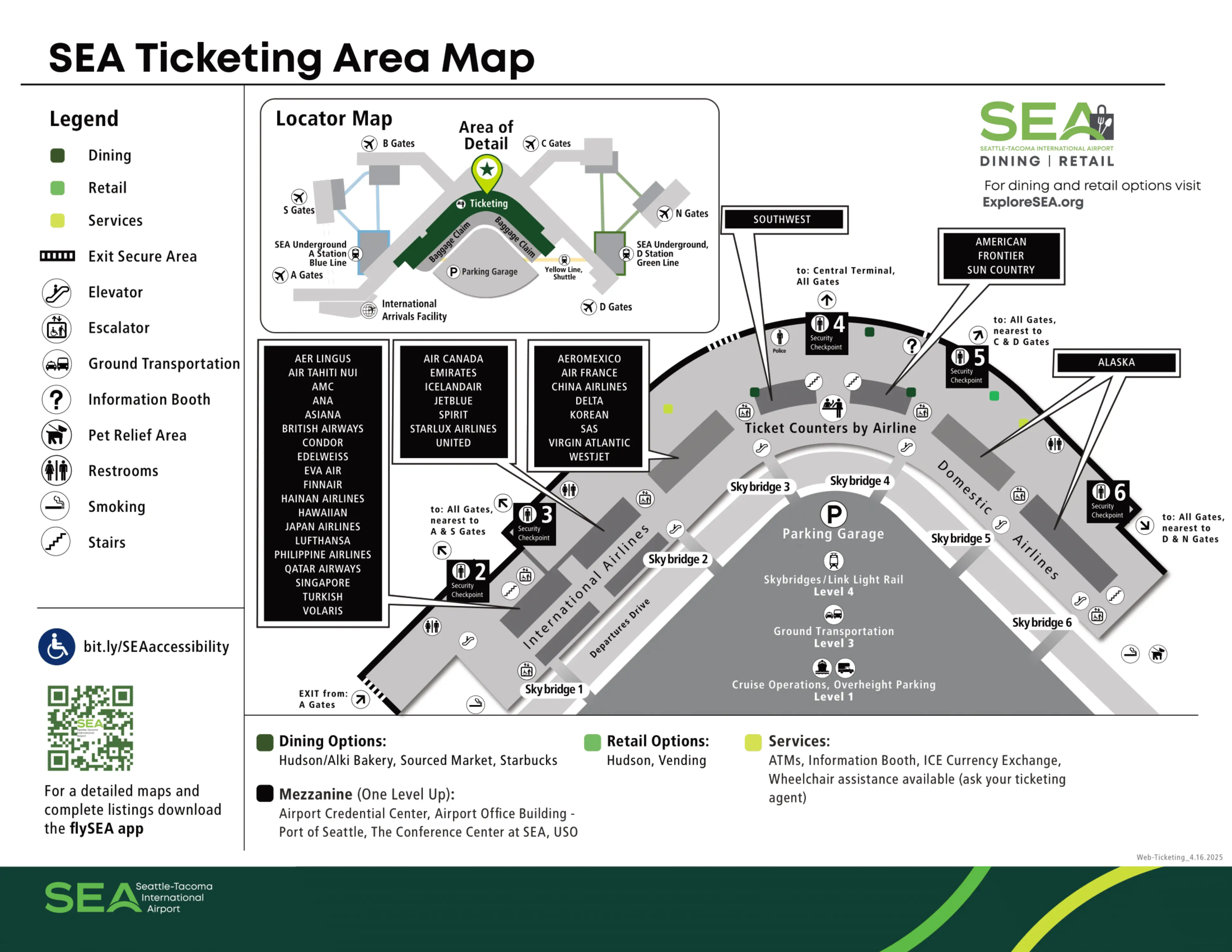
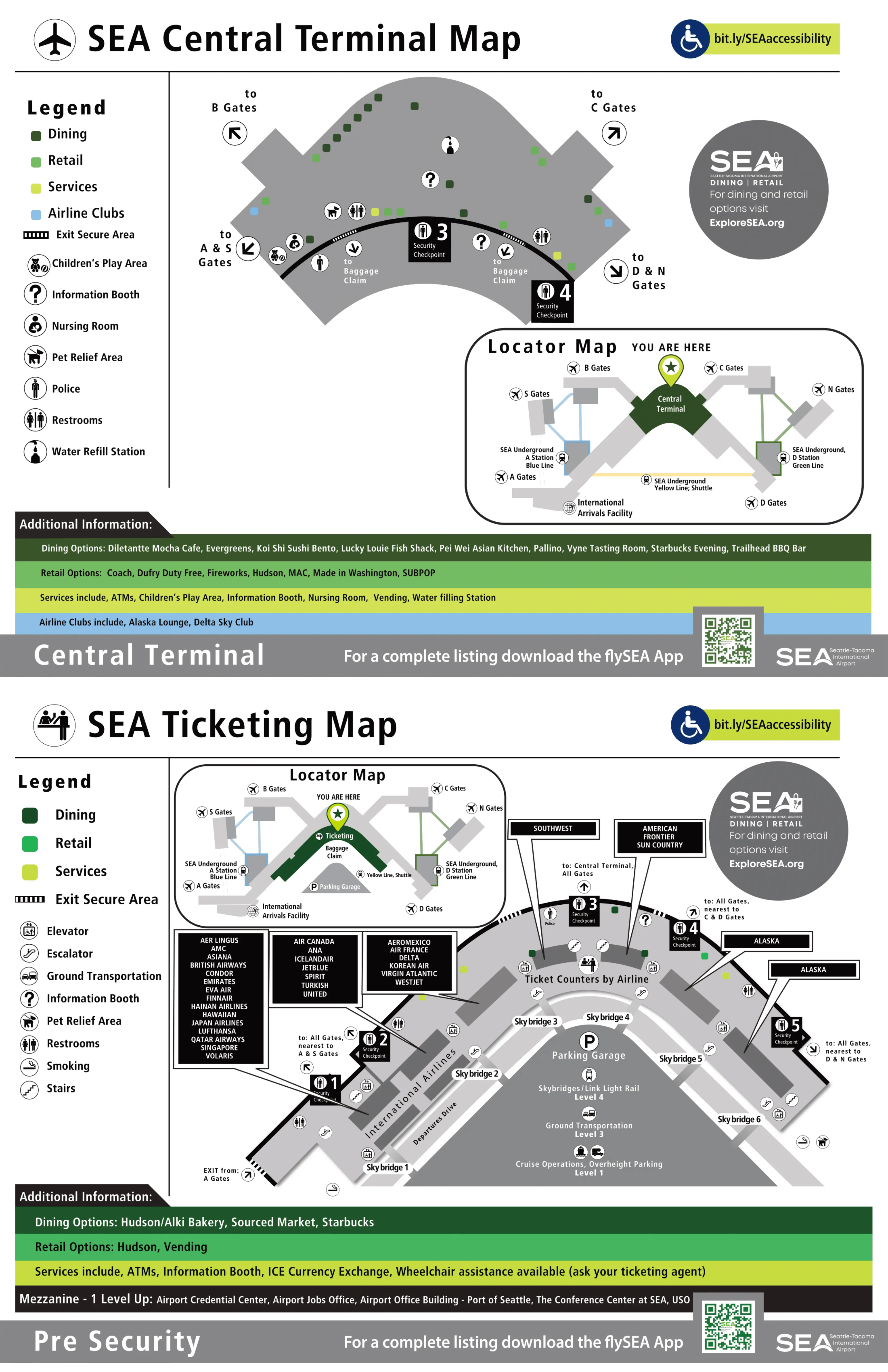
In 2026, the Central Terminal’s “rules” are defined by checkpoint renumbering, shifting queue footprints, and Upgrade SEA construction that narrows the C/D junction. Checkpoint 1 (baggage level) stays the key vertical bypass when you’re bag-less, while the SEA Underground remains mandatory for North and South Satellites—no sterile walk alternative exists for departing passengers.
Seattle–Tacoma International Airport Central Terminal Map 2025
Seattle–Tacoma International Airport Central Terminal Ticketing Area Map 2025
2026 Seattle–Tacoma International Airport Central Terminal Map Guide
What is the shortest walking route from Security Checkpoint 1 exit to the Concourse C / C16 train-platform entrance (C/D/N line)?
The C/D/N “train platform at C16” is not possible because the Green Line C Station access point is at Gate C11, not at Gate C16. From Checkpoint 1, the shortest low-stress route is to descend immediately to the A Station and use the Yellow Line to D Station, then transfer to the Green Line to C Station and walk to C16.
From the Checkpoint 1 exit landing, skip the escalator up to A gates and go down to the A Station (SEA Underground). Ride the Yellow Line shuttle to D Station, cross the platform to the Green Line, and ride one stop to C Station. Ride the escalators up and you’ll emerge at Gate C11; from Gate C11, turn left (away from the Central Terminal) and walk roughly 600 feet to the Gate C16 area.
What is the shortest walking route from Security Checkpoint 6 exit to the North Satellite (N Gates) train boarding point?
Walking to the North Satellite is not possible because there is no public pedestrian route to N Gates; the SEA Underground train is mandatory. From the Checkpoint 6 exit, the boarding point is the D Station entrance directly by Gate D2.
Exit Checkpoint 6 into the airside corridor and aim immediately for Gate D2 at the start of Concourse D. The SEA Underground entrance is the escalator bank down to D Station beside Gate D2 (look for the station signage and the art overhead). Descend to the platform and board the Green Line train signed for North Satellite; the loop runs D → C → N, and you’ll exit at N Station.
Where is the exact platform entrance for the A/B/S train line when starting from the Central Terminal post-security core (nearest named landmark/food court node)?
The A Station entrance for the A/B/S (Blue Line) train is directly across from Gate A3, reached from the Central Terminal food court by walking toward the south A-concourse throat. From the food court window wall, the A3 escalator bank down is the reliable landmark for the Blue Line.
Stand in the Central Terminal food court facing the large window wall toward the runways, then turn left (south) and walk into the Concourse A corridor. Continue past the first A-gate storefronts until you reach the Gate A3 zone; the SEA Underground entrance is opposite Gate A3 with a clear escalator/elevator “Train to B/S Gates” descent. Follow Blue Line signage once on the platform.
What is the walking distance (in feet/meters) from Concourse D’s nearest post-security junction to the C/D/N train platform (D-gate stop) entrance?
The walk is about 150–200 feet (45–60 meters) because the D Station entrance sits right beside Gate D2 near the start of Concourse D. From the immediate post-security D-concourse junction, it’s under a minute on flat flooring.
Start at the confluence where the Central Terminal airside corridor feeds into the D pier near Gate D1. Walk straight toward Gate D2; the SEA Underground D Station entrance is the adjacent escalator bank down at the Gate D2 area (station signage overhead). This distance is often confused with the longer span from the food court core (closer to ~900–1,000 feet), but from the D “throat” junction it’s only a short hop.
From Concourse C Gate C16 area, what is the exact decision point (fork/turn) that separates “walk to D gates” vs “descend to C/D/N train”?
Gate C11 is the decision point because it is the only C-concourse location with the SEA Underground C Station entrance, and walking past it commits you to an overland route toward D and the Central Terminal. From the C16 area, you must backtrack to C11 before you can choose between stairs/escalators down to the train or continuing straight on the concourse.
From Gate C16, walk back toward the Central Terminal until you reach the Gate C11 zone. At C11, the “fork” is literal: the escalator/elevator bank down to the C Station is the descend option for N Gates, while staying on the main concourse path (not going down) is the walk option for D gates and the Central Terminal corridor. If your destination is D, staying upstairs is typically faster than riding the Green Line loop C → N → D.
What is the shortest indoor route from Central Terminal main food court area to the nearest staffed information desk (or equivalent help point) post-security?
The nearest staffed help point is the information booth at the Central Terminal–Concourse A junction near the Dufry store. From the food court core, it’s a short southbound walk to the A “throat” where the concourse corridor begins.
Stand in the center of the Central Terminal food court facing the window wall, then turn right (southbound toward Concourse A) and walk along the main circulation path toward the A-gates entrance corridor. As you approach the Concourse A throat, look for the Dufry storefront; the staffed information booth sits at this intersection node where foot traffic splits between the Central Terminal core and the A concourse.
After an international arrival, what is the exact path from the international baggage re-check flow / Carousel 1 area to the nearest TSA checkpoint entrance back upstairs (include door numbers/landmarks)?
The nearest TSA checkpoint is the dedicated IAF checkpoint directly above the international re-check corridor, not a main-terminal checkpoint upstairs. From Carousel 1, the fastest “back to gates” route stays inside the International Arrivals Facility flow and re-enters security there.
From Carousel 1 in the south baggage-claim/IAF area (Door 00 / Door 02 vicinity), follow the “Connecting Flights” split (not “Exit to Seattle”). Stay in the corridor to the airline bag re-check counters and complete the re-check drop immediately there. Continue forward to the escalators/elevators signed for the IAF TSA checkpoint on the mezzanine level directly above the re-check zone. After screening, you re-enter the secure side of Concourse A near the Gate A10/A11 corridor rather than returning to the ticketing-level checkpoints.
What is the walking distance from Carousel 1 (international arrivals) to the United check-in counters in the Central Terminal (landside)?
The walk is about 200–250 feet (60–75 meters) plus the vertical ride because United’s ticketing area is essentially directly above the Carousel 1 south baggage-claim zone. The only real time cost is getting to the nearest elevator/escalator and moving up to the ticketing level.
Start at Carousel 1 in the international arrivals baggage-claim area near Door 00 / Door 02. Walk to the closest vertical core by Door 2 on the garage side of the hall, then go up from Level 3 (baggage claim) to Level 5 (ticketing). When you exit the elevator/escalator bank, United check-in is in the south ticketing hall (Zone 1 / Zone 2 area), with minimal horizontal walking once you’re upstairs.
Where is the closest elevator bank from international-arrivals exit flow that reaches the departure-level checkpoint entrances without exiting the building?
The closest elevator bank is the Door 2 elevator core on the east (garage) side of the Gina Marie Lindsey Hall, and it takes you up to the Level 5 ticketing/checkpoint entrances without going outside. If you’re eligible for Checkpoint 1, you can also avoid elevators entirely because it sits in the same Level 3 hall.
Exit the IAF into the Gina Marie Lindsey Hall (south baggage claim) and orient to the garage side wall where Door 2 is signed. Walk north a short distance past Door 00 toward Door 2; the elevator bank there serves the vertical jump to Level 5. Ride up to the ticketing level and you’ll emerge at the south end of the main checkpoint zone (closest to the central/south checkpoints), all while staying inside the building.
Which security checkpoint entrance is closest landside to the Alaska ticketing counters (by doors), minimizing curb-to-line walking?
Checkpoint 6 is the closest landside security entrance to Alaska ticketing, accessed most directly from Doors 25–26. Entering at Door 25 minimizes curb-to-line walking because the Alaska counters and the Checkpoint 6 queue are adjacent in the north ticketing lobby.
From the curb, go to the far-north ticketing doors and enter at Door 25 (Door 26 is the next-best alternative). Alaska Airlines check-in is immediately inside in the north sector; from there, the Checkpoint 6 entrance is the nearest checkpoint on the north wall of the ticketing hall, positioned for the C/D/N side of the airport.
Which security checkpoint entrance is closest landside to the Link Light Rail bridge/terminal entry point (shortest indoor walk)?
Checkpoint 6 is the closest security entrance to the Link Light Rail skybridge entry because the rail-to-terminal flow feeds the north side of the main terminal near Skybridge 6. This makes CP6 the shortest indoor walk from the garage/bridge arrival into the ticketing hall.
From the Link Light Rail station, follow signs into the parking garage and then to Skybridge 6 (the north-end bridge). After crossing into the terminal, stay oriented to the north ticketing lobby; the closest checkpoint entrance is Checkpoint 6, which sits in the far-north checkpoint cluster aligned with Alaska’s side of the building. If Skybridge wayfinding drops you slightly off-level, follow internal signs to the ticketing/checkpoint level while holding a “north” orientation toward the Alaska sector.
Post-security, where is the closest restroom to the South Satellite train arrival point (first reachable facility after disembarking)?
The closest restrooms are on the South Satellite concourse level near Gates S8–S9, reached immediately after you ride the escalators up from the S Station train platform. There is no faster “on-platform” public restroom option for most passengers.
After disembarking the Blue Line train at S Station, take the escalators up to the South Satellite concourse. You’ll arrive into the central hub area; follow the nearest restroom signage toward the Gates S8 and S9 cluster, which is the first major restroom block reachable from the escalator landing. If you see gate-direction signs fanning out from the hub, stay in the central node rather than walking deep into either pier.
Post-security, where is the closest restroom to the North Satellite train arrival point (first reachable facility after disembarking)?
The closest restrooms are on the North Satellite concourse level near Gates N1–N2, immediately off the “Marketplace at N” area you enter after taking the escalators up from N Station. This is the first major restroom core reached from the train arrival.
After you step off the Green Line train at N Station, take the escalators up to the North Satellite concourse. You’ll emerge into the Marketplace at N hub; follow restroom signage toward the Gates N1 and N2 side of the hub, where the primary restroom block (often including family facilities) is located. Staying in the marketplace node is faster than walking down either gate pier before looking.
What is the shortest route from the Central Terminal core to the Centurion Lounge access point (exact stairs/elevator location and nearest storefront landmark)?
The Centurion Lounge entrance is reached from the Central Terminal food court by going up one level via the dedicated stairs/elevator tucked beside the Evergreens restaurant. The access point is easy to miss because it sits on the mezzanine and doesn’t front the main walking path.
From the food court core, walk toward Evergreens and stop at its storefront edge. Look immediately adjacent/behind Evergreens for the dedicated elevator bank and the short staircase (about 32 steps) that goes up one level. Take either vertical option to the mezzanine and turn toward the lounge entry at the top landing, using Evergreens below as your reference anchor for the return trip.
What is the shortest route from the Central Terminal core to the nearest “quiet zone” seating cluster (least-through-traffic area) post-security?
The quietest close-by zone is on the A Station train level because it sits below the Central Terminal flow and hosts the Sensory Room and the Interfaith Prayer/Meditation Room corridor. This route intentionally escapes the Central Terminal choke-point rather than trying to find “quiet” along the main window wall.
From the Central Terminal core, walk south toward the Concourse A throat until you reach the Gate A3 area. Descend via the A Station escalator/elevator bank (the same drop used for the Blue Line). On the train level, follow signage for the Sensory Room and Prayer/Meditation Room; the hallway outside these rooms functions as a low-through-traffic pocket compared with the food court. The window-wall rocking chairs upstairs are calmer than the food court, but they are still in the primary circulation stream.
Archive Seattle–Tacoma International Airport Central Terminal Maps
Below are all historical map versions for Seattle–Tacoma International Airport. Each year includes the official map available for that period, presented as both WebP and PDF.
Seattle–Tacoma International Airport Central Terminal Map 2023
Seattle–Tacoma International Airport Central Terminal Map 2021