Sacramento International Airport Map (Most Up-To-Date)
Sacramento International Airport uses a horseshoe loop road around a central parking hub, with Terminal A on the east side of the loop and Terminal B on the north/west side. The parking garage and Daily Lot sit in the middle and act like the connective tissue between both terminals, while the Economy lots sit farther out and function as shuttle-dependent islands within Sacramento’s main airport hub.
Map Table
| Terminal | Key Airlines | Primary Function | Transfer Mode |
|---|---|---|---|
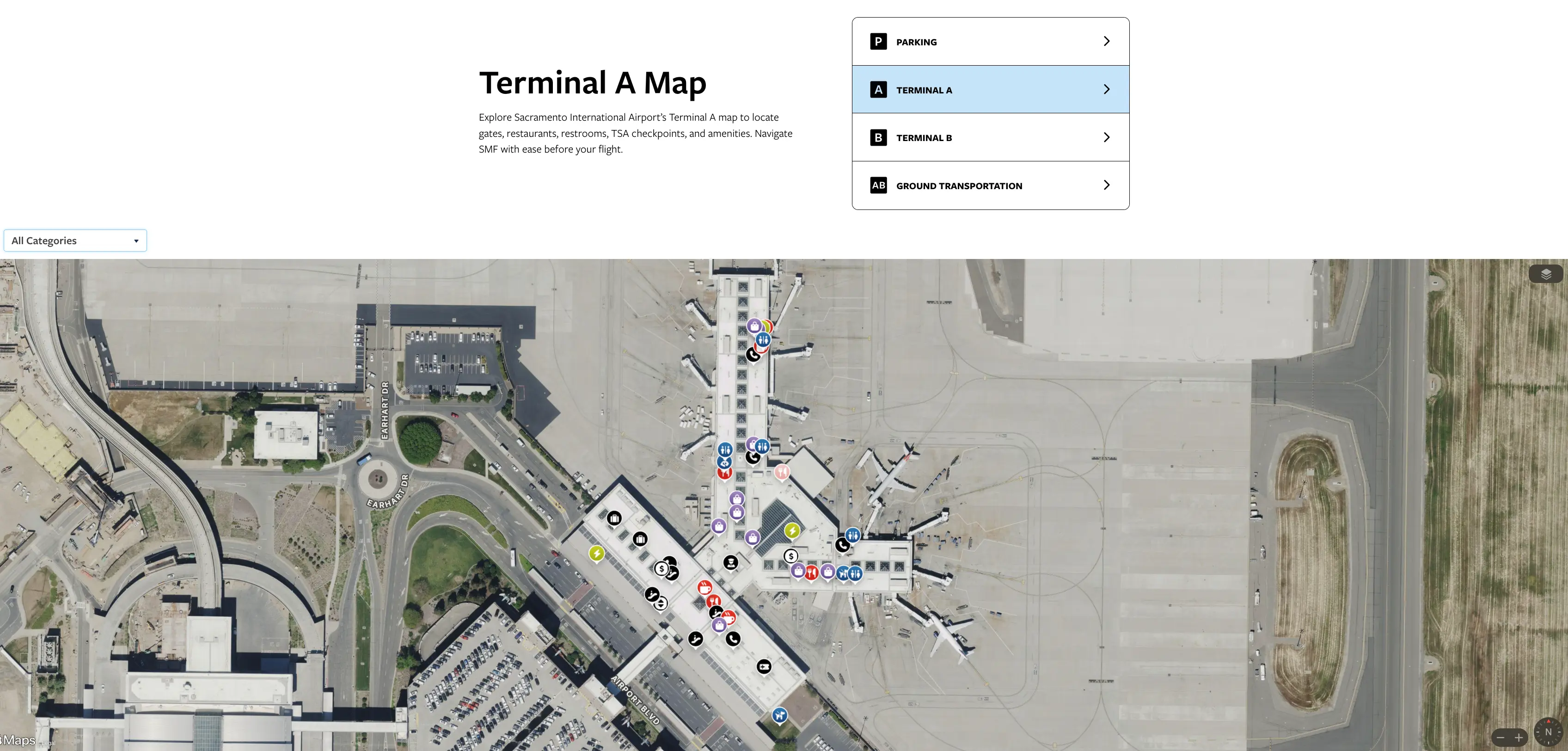
| Terminal A | Southwest, Alaska | Check-in, security, gates A | Walk, shuttle curb |
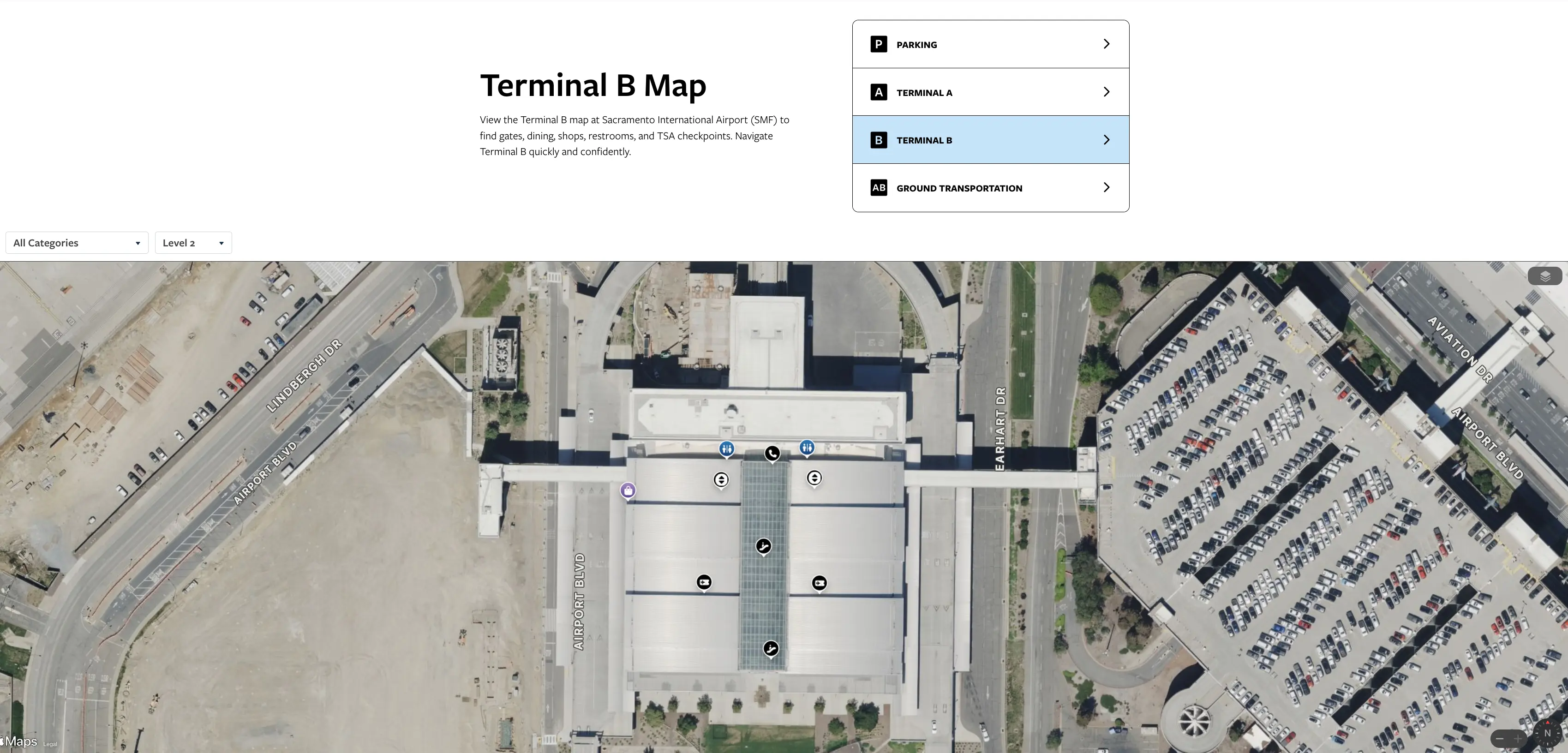
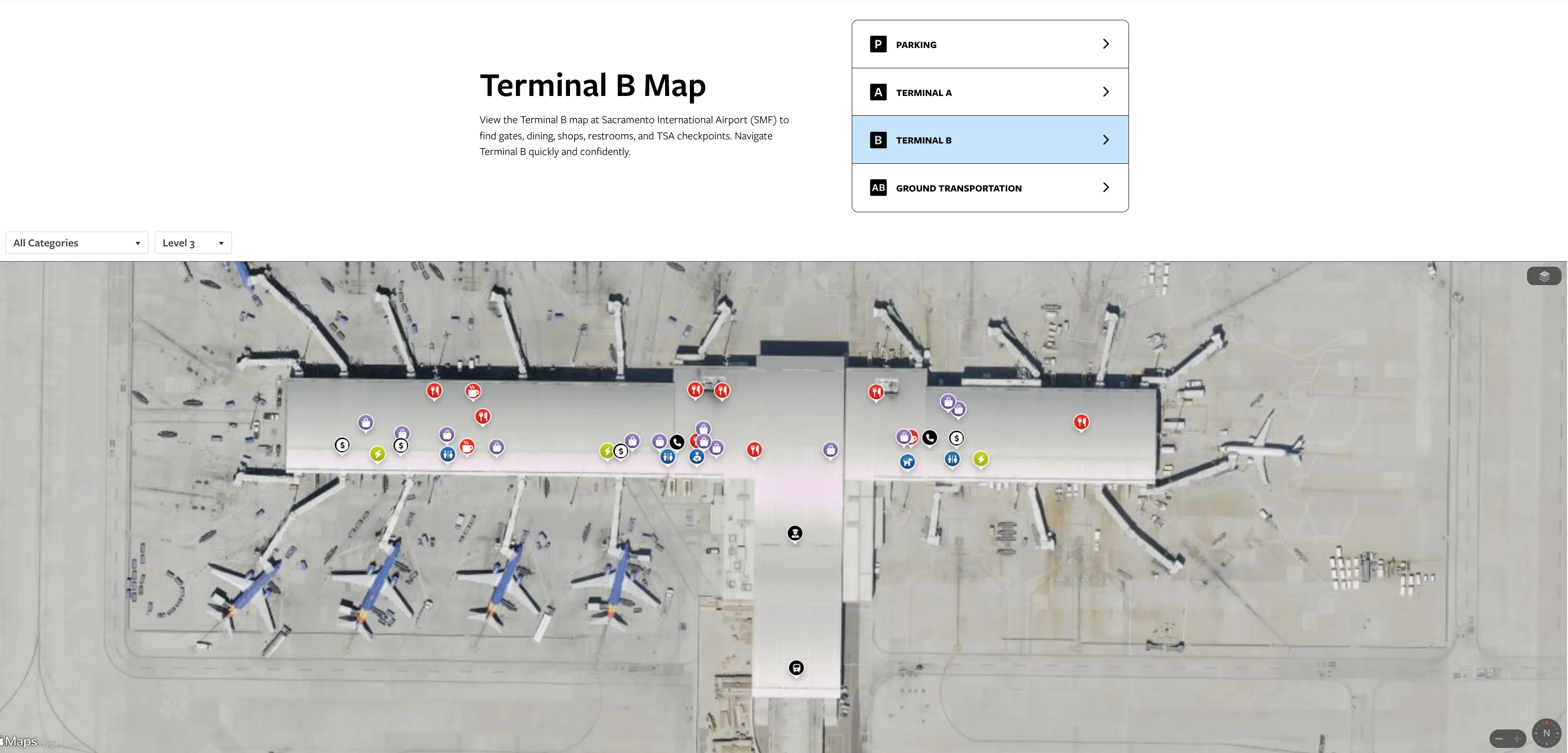
| Terminal B | American, United, Delta | Landside processing, people-mover to gates B | People-mover, garage skybridge |
| Parking Garage | All terminals | Central connector, short-walk parking | Skybridges, elevators |
Sacramento International Airport Map Strategy
- Treat Economy Parking as shuttle-only: no safe pedestrian escape path, so a missed or full shuttle can force an entire wait cycle; the Daily Lot and parking garage are the reliable walkable upgrades when timing matters.
- Use a walk-versus-shuttle trigger: if you want a fixed arrival buffer, park where you can walk (Daily Lot to parking garage to skybridge) instead of betting on shuttle frequency and capacity.
- Separate Terminal A versus Terminal B expectations: Terminal A is linear and curb-to-check-in is straightforward; Terminal B bakes in level changes and a mandatory train link to reach gates.
- Pin the Terminal B people-mover step early: ticketing is on Level 2, but boarding for the people-mover is on Level 3—plan your vertical move (escalator or elevator) before you start looking for gates.
2026 Sacramento International Airport Map + Printable PDF
Active SMForward construction keeps 2026 ground logistics in motion, especially around Terminal B circulation and parking supply. Terminal B remains a split design (landside building plus a people-mover to the concourse), which is the single biggest wayfinding and time-buffer variable. If nearby lots shift or close during work windows, the parking garage and Daily Lot remain the most deterministic car-to-terminal choices compared with Economy shuttle variance.

Sacramento International Airport Terminal A Map 2026
Sacramento International Airport Terminal B Level 1 Map 2026

Sacramento International Airport Terminal B Level 2 Map 2026
Sacramento International Airport Terminal B Level 3 Map 2026
2026 Sacramento International Airport Map Guide
What is the exact walking distance from the farthest point of SMF Economy Parking to the Terminal A departures doors (feet/meters)?
No safe walking route exists from Economy Parking to Terminal A at Sacramento International Airport, so the practical walking distance is effectively “not walkable.” The farthest-point straight logistics figure used in the audit is about 1.6 miles (2.6 kilometers), but it relies on roadway shoulders and ramp edges rather than a continuous sidewalk.
Economy lots sit outside the airport’s pedestrian grid, separated from the terminal core by Airport Boulevard circulation lanes and ramp geometry. If you’re dropped into the far end of Economy, the only deterministic path is Economy Shuttle → Terminal A center-island drop-off, then a short curb-to-doors walk at Terminal A.
Where are the Economy Parking shuttle stops located, and what is the shortest mapped walking distance from each stop to the Terminal B entrance?
The Economy Parking shuttle drop-off for Terminal B is the Ground Transportation Center on Level 1 at the center-island bus bays, and the shortest walk from the drop area to the Terminal B entrance is about 280 feet (85 meters). Economy Parking pickup stops in the lots are marked shelters distributed through the East, West, and South Economy areas.
- East Economy Lot marked shuttle shelters throughout the rows
- West Economy Lot marked shuttle shelters throughout the rows
- South Economy Lot marked shuttle shelters throughout the rows
- Terminal B drop-off center-island bus bays at the Ground Transportation Center (Level 1), then ~280 feet (85 meters) to the entrance doors via the crosswalk and curb approach
What is the exact landside walking distance between Terminal A check-in and Terminal B check-in using the signed pedestrian route?
Walking between Terminal A and Terminal B using the signed garage skybridge route takes about 2,200 feet (670 meters), roughly 0.42 miles. The signed route runs through the parking garage connector, not along the curb roadways.
| Segment | Signed route anchor | Distance |
|---|---|---|
| Terminal A check-in level to garage skybridge | Terminal A Level 2 bridge | ~200 ft |
| Garage traverse | parking garage interior path toward “Terminal B” signs | ~1,500 ft |
| Terminal B side bridge approach | garage-to-Terminal B skybridge area | ~200 ft |
| Total | garage connector route | ~2,200 ft / 670 m |
In Terminal B, what is the exact walking distance from the ticketing hall to the APM (people-mover) boarding point required to reach the gates?
The horizontal walk from Terminal B ticketing to the people-mover boarding area is about 150 feet, but the required move is vertical from Level 2 up to Level 3. The boarding point sits on the Level 3 bridge/APM level, not on the ticketing level.
From the ticketing hall on Level 2, follow signs toward the escalator/elevator bank that leads to Level 3. The path is short across the hall to the vertical cores, then you arrive at the people-mover queue and platform area on Level 3. During peak banks, the queue can spill into the Level 3 hallway, so the “distance” feels longer because of the stop-and-go choke point rather than the walk itself.
What is the exact mapped distance from Terminal A baggage claim to the rental car shuttle pickup curb/stop (current setup)?
The walk from Terminal A baggage claim to the rental car shuttle pickup is about 60 feet (18 meters). The pickup point is on the center median island of the ground transportation curb.
Exit Terminal A baggage claim doors to the ground transportation curb, then cross the inner lane to the center median where the rental car shuttle boards. This median can bottleneck in busy windows because it’s narrow and shared with other commercial pickups, so the key time variable is often waiting space and bus loading, not the walking distance.
Where is the rideshare (Uber/Lyft) pickup zone for Terminal B, and what is the shortest indoor-to-outdoor walking route distance from Terminal B baggage claim to that zone?
The Terminal B rideshare pickup zone is at the Lindbergh Curb (West Commercial Curb), and the shortest signed walk from the center of baggage claim to that pickup area is about 550 feet (165 meters). The route starts at Level 1 baggage claim and ends outside at the west-side curb zone.
From baggage claim on Level 1, exit through the doors closest to the west-side ground transport flow, then follow “App-Based Rideshare” wayfinding toward the Lindbergh Curb. The path uses marked crosswalks and a covered walkway section; the friction point is the roadway crossing and the extra offset away from the immediate terminal curb where taxis and private pickups stage.
If a traveler chooses to walk instead of waiting, what is the shortest safe pedestrian route distance from Economy Parking to Terminal B (and where does it enter the terminal curb area)?
No safe pedestrian route exists from Economy Parking to Terminal B at Sacramento International Airport, so the shortest safe walking distance is effectively “not walkable.” The pedestrian grid ends around the Daily Lot and parking garage, and Economy lots sit beyond the loop roadways without continuous sidewalks or protected crossings.
Economy Parking requires the shuttle to reach Terminal B’s Ground Transportation Center on Level 1. That shuttle drops at the center-island bus bays; from there, the terminal curb/door entry is reached via the marked crosswalk and curb approach into the Level 1 doors.
Where do inter-terminal shuttle drop-off points sit relative to the terminals, and what is the exact walking distance from each drop point to the nearest security entrance?
Inter-terminal shuttles drop at Terminal A’s center-island curb area and at Terminal B’s Ground Transportation Center, and the walk to security is much shorter at Terminal A than Terminal B because Terminal B also requires the people-mover step. The audit distance figures are about 200 feet at Terminal A versus about 800 feet plus the required people-mover ride at Terminal B.
| Drop-off point | Relative location | Walk to security |
|---|---|---|
| Terminal A inter-terminal shuttle | center island at the ground transportation curb | ~200 ft (enter, then up to security level) |
| Terminal B inter-terminal shuttle | Ground Transportation Center (Level 1) bus bays | ~800 ft to the people-mover/security path + required people-mover ride to reach the concourse security area |
From Terminal B baggage claim, what is the exact walking distance to the taxi stand using the signed route?
Walking from Terminal B baggage claim to the taxi stand takes about 75 feet (23 meters). The taxi pickup is at the immediate east curb near Doors 1 and 2 on Level 1.
From the baggage claim area, head to the east-side exit doors (Doors 1–2) and step out to the curb where taxis queue. This is the “closest curb” option at Terminal B and is roughly 450+ feet closer than the app-based rideshare pickup at the Lindbergh Curb.
What is the exact curbside walking distance between the Terminal A ground-transport curb and the Terminal B ground-transport curb (for travelers dropped at the wrong terminal)?
The curbside walk between Terminal A ground transport and Terminal B ground transport is about 0.4 miles, but the designated pedestrian connection is the garage skybridge route rather than the curb roadway edge. The curb route is less predictable because of traffic lanes and gaps in continuous pedestrian protection in transition zones.
The controllable “wrong terminal recovery” move is to enter the parking garage connector and follow signs between terminals instead of staying curbside. That signed path keeps you inside the pedestrian grid, avoids the loop-road pinch points, and lands you near each terminal’s primary processing level rather than forcing curbside lane crossings.


