Phoenix Sky Harbor International Airport Map (Most Up-To-Date)
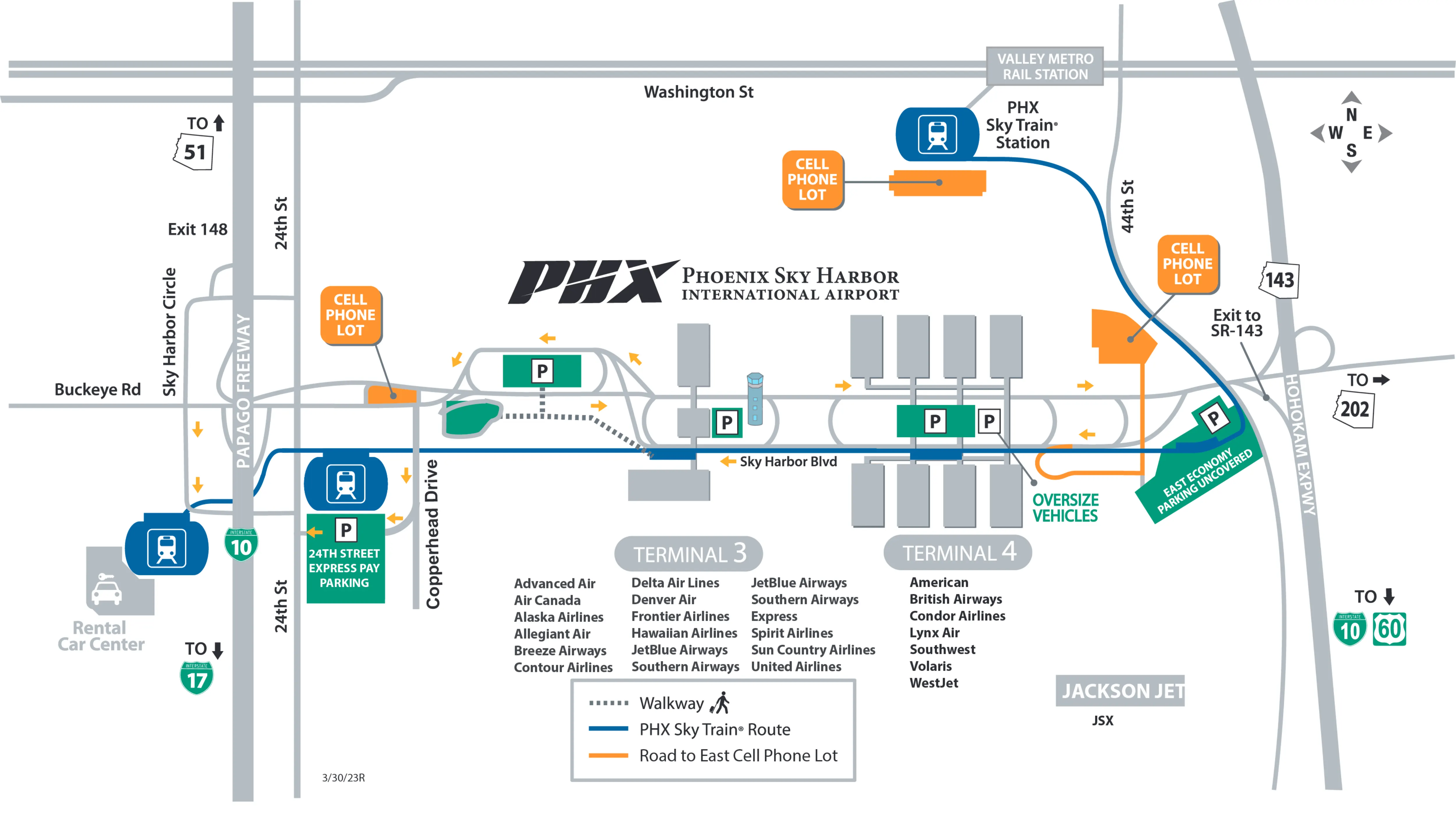
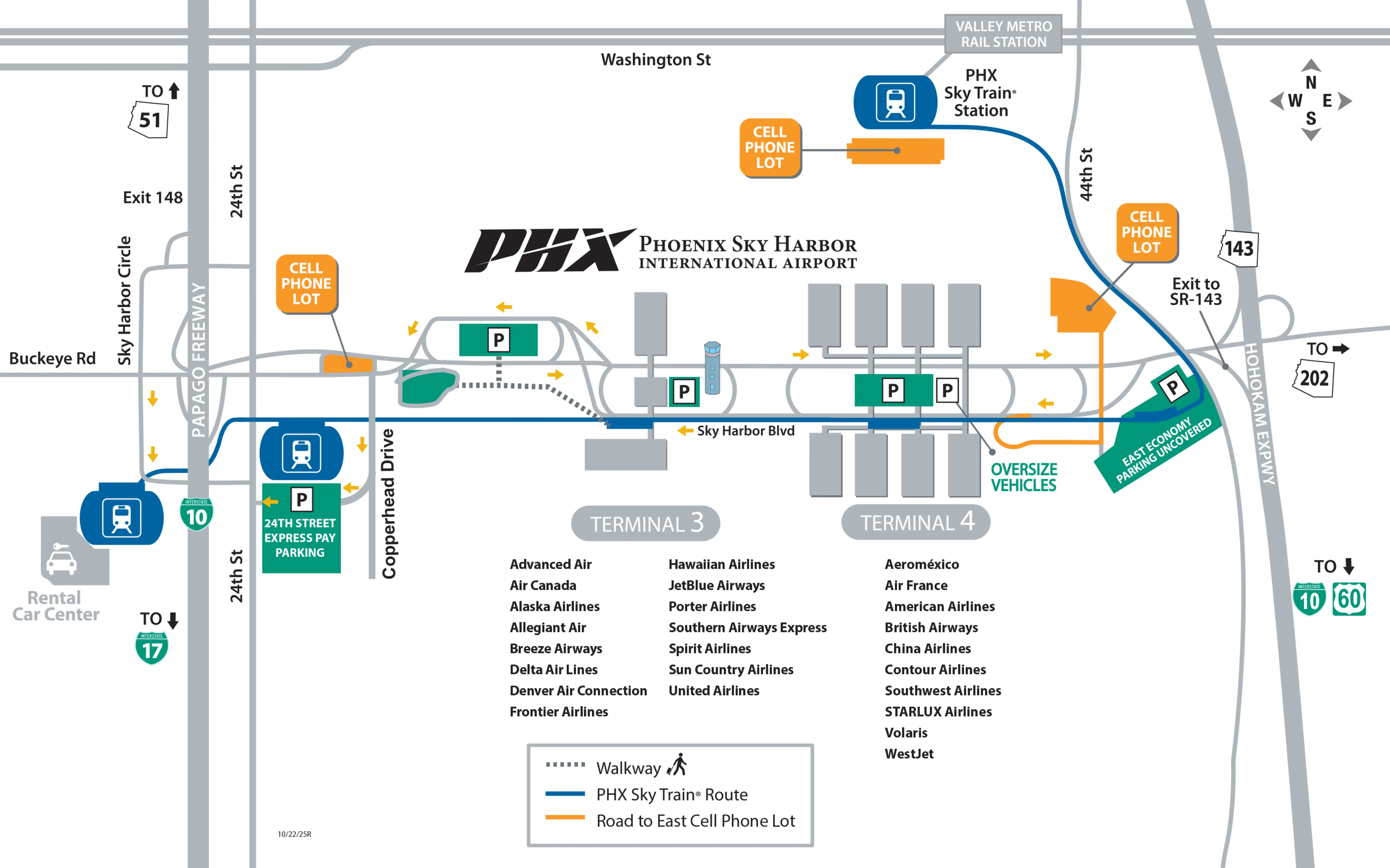
Phoenix Sky Harbor International Airport (PHX) is laid out as a multi-terminal campus anchored by Terminals 3 and 4, with the PHX Sky Train running east–west as the primary connector to parking, Valley Metro Rail, and the Rental Car Center. The road system funnels vehicles into early, high-stakes lane splits (Arrivals vs. Departures, then North vs. South curb faces), especially at Terminal 4. At the Valley’s main airport hub, most “wrong turn” outcomes become full loops rather than quick fixes.
Map Table
| Terminal | Key Airlines | Primary Function | Transfer Mode |
|---|---|---|---|
| Terminal 4 (Barry M. Goldwater) | American, Southwest | Primary passenger processing | PHX Sky Train (Level 3), curb loop (Level 1/3) |
| Terminal 3 (John S. McCain III) | Delta, United, JetBlue | Passenger processing | PHX Sky Train (Level 4/5), curb loop |
| Rental Car Center (RCC) | All major brands | Consolidated rental facility | PHX Sky Train (westbound) |
| 24th St Station / 44th St Station | Private pickup, rail users | Off-terminal pickup nodes | PHX Sky Train (west/east) |
Phoenix Sky Harbor International Airport Map Strategy
- Commit early for Terminal 4: decide Arrivals (Level 1) vs. Departures (Level 3) before the SR-143 overpass zone, then commit North (odd doors) vs. South (even doors) before the curb face forces a full loop.
- Treat curb legality as a routing rule: private pickup on the inner curb, rideshare on the outer curb only; Door 1 (North outer) and Doors 2/6/8 (South outer) are the reliable rideshare targets.
- Use the Sky Train to delete roadway risk: default pickups to 24th Street (south curb) or 44th Street (north curb) when congestion, enforcement pressure, or wrong-loop penalties are likely.
- Plan vertical moves, not just horizontal ones: Terminal 4 Sky Train access is on Level 3 with an east-side bias, and terminal changes via Sky Train mean exiting security and re-screening.
2026 Phoenix Sky Harbor International Airport Map + Printable PDF
In 2026, PHX’s navigation “gotchas” remain concentrated groundside at Terminal 4: the Arrivals (Level 1) vs. Departures (Level 3) split happens before you have comfortable visual confirmation, and the North vs. South curb commitment is hard to undo. The PHX Sky Train continues to be the cleanest way to bypass terminal-loop stress via 24th Street and 44th Street stations.
2026 Phoenix Sky Harbor International Airport Map Guide
What is the exact lane-split point (by ramp/merge landmark) for Terminal 4 Departures when approaching the terminal loop from the primary inbound roadway?
The Terminal 4 Departures split happens at the SR-143 overpass decision zone, where the “Level 3 / Departures” ramp peels left/center and commits you before the final approach bridge. From the westbound inbound flow on Sky Harbor Blvd, the key cue is the approach to (and then under) the SR-143 structure: once you pass the last clear sign set before the pillars, you’re effectively locked into either the left/center Departures climb or the right-side Arrivals/through movement.
The most repeatable landmark sequence is: Sky Harbor Blvd inbound → signage cluster immediately before the SR-143 overpass → gore point at the overpass where the Departures ramp separates toward the left/center. If you miss that peel-off and stay right, you’ll be carried into the Arrivals/Level 1 path or pushed into the through-road movement that forces a loop-out and re-approach rather than a quick correction.
What is the exact lane-split point (by ramp/merge landmark) for Terminal 4 Arrivals when approaching the terminal loop from the primary inbound roadway?
The Terminal 4 Arrivals split is the far-right commitment before the SR-143 overpass, where the “Arrivals / Level 1” movement cuts off as the right-side ramp while Departures continues as the more obvious left/center climb. The practical decision point is not at the terminal face—it’s the approach into the SR-143 pillar zone, because the overpass supports and medians create a last-second readability problem.
The most reliable landmark sequence is: Sky Harbor Blvd inbound → move to the far-right lane before reaching the SR-143 overpass → take the right-side Arrivals (Level 1) ramp at the gore point adjacent to the overpass. If you’re still in the center lanes when you enter the overpass zone, the roadway geometry tends to “carry” you into the Departures (Level 3) path or the wrong through movement, and the correction cost becomes a full loop exit and re-entry instead of a simple lane change.
Where is the Terminal 4 → PHX Sky Train entrance (exact level + corridor alignment relative to the terminal center)?
The Terminal 4 PHX Sky Train entrance is on Level 3 (Departures level) and aligns center-to-east relative to the terminal core, closest to the C/D checkpoint side. From inside the main departures hall, the usable bias is “go east” rather than “go toward the middle,” because the bridge connector sits on the east side of the central spine.
From Level 1 (baggage claim), the fastest setup is to move toward the east end near Doors 6–8, then take escalators/elevators up to Level 3. On Level 3, follow overhead “PHX Sky Train” branding toward the east-side connector corridor near the D-checkpoint area; that corridor becomes the bridge to the station. If you come from the west side (A/B gates or west baggage carousels), expect extra walking because the station interface is not west-centered—it’s east-biased.
Where is the Terminal 3 → PHX Sky Train entrance (exact level + corridor alignment relative to the terminal center)?
The Terminal 3 PHX Sky Train entrance is accessed from Level 4 (ticketing/bridge level), then you ascend again to Level 5 for the boarding platform. The corridor alignment is on the west side of Terminal 3’s main structure, using an elevated bridge connection rather than a ground-adjacent entry.
From baggage claim (Level 1), the cleanest route is vertical first: take elevators/escalators up to Level 4, then follow “PHX Sky Train” signage across the bridge. After entering the station structure, continue upward to Level 5 to reach the train platform. The operational “gotcha” is that this is a double ascent (1 → 4 → 5), so luggage and elevator queues can add noticeable time compared with Terminal 4’s simpler Level 3 interface.
What is the exact walking distance from Terminal 4 Security Checkpoint A to the midpoint of the high-numbered B-gates corridor?
Walking is approximately 1,800 feet (about 550 meters) from Terminal 4 Security Checkpoint A to the midpoint of the high-numbered B-gates corridor (around the B20 area). That distance reflects the cross-core traverse plus the pier walk into the higher-numbered B gates.
The route runs Checkpoint A → across the central core/food court spine (roughly 300–500 feet of lateral crossing) → into the B-gates connector → along the B pier to the midpoint of the high-number corridor. Using a typical airport walking pace, the time budget is about 8–12 minutes, with the biggest variability coming from congestion in the central core and any out-of-service moving walkways.
What is the exact walking distance from the Terminal 4 PHX Sky Train platform to the nearest Terminal 4 security checkpoint entrance?
Walking is approximately 720 feet (about 220 meters) from the Terminal 4 PHX Sky Train platform interface to the nearest Terminal 4 security checkpoint entrance, with the closest checkpoints being C or D on the east side. This is the “best case” distance because the Sky Train bridge enters Terminal 4 on the C/D side rather than near A/B.
From the train, the path is: station exit → down the station stairs/escalator bank into the connector flow → walk the bridge corridor into the terminal’s east-side departures hall → continue a short distance to the C/D checkpoint entry lanes. If you need Checkpoint A or B for American’s west-side flows, add a cross-terminal walk through the central commercial core after you enter the building, which typically adds several more minutes.
Where is the exact Terminal 4 rideshare pickup curb (outer/inner curb positioning) relative to the terminal doors on the arrivals level?
Rideshare pickup at Terminal 4 is on the outer curb on Level 1, not the terminal-adjacent inner curb, and it is constrained to specific door ends rather than the entire frontage. On the North side, the rideshare zone concentrates at the far west end outside Door 1 on the outer curb; on the South side, rideshare uses the outer curb zones outside Doors 2 (west end) and Doors 6 and 8 (east end).
The physical rule is the median-separated split: the inner curb sits directly against the terminal doors (private active loading), while the outer curb sits across the traffic lanes on the “traffic side” (TNCs, shuttles, commercial). If a passenger waits at an inner-curb door expecting Uber/Lyft, they can be visible to the driver but unreachable because the driver is geofenced to the outer lanes and cannot legally cross over.
Which specific Terminal 4 door range is closest to the fastest curb-to-road exit path for vehicles leaving the pickup area?
Door 8 on the South side (Level 1 outer curb) is the closest door target to the fastest curb-to-road exit path, because it sits at the far east end adjacent to the loop’s exit movement back to Sky Harbor Blvd. That positioning minimizes the amount of terminal frontage you must traverse before you can merge out.
The practical door strategy is: if you want maximum exit velocity, bias pickups to the South curb and push passengers toward Door 8 (or Door 6 if Door 8 is jammed), then commit to the outer curb if it’s rideshare. By contrast, pickups at the North west end near Door 1 are the slowest to “extract” because you must travel the length of the curb frontage and then fight heavier mixing flows (taxis/shuttles) before you reach the exit merge.
What is the exact pedestrian route from Terminal 4 baggage claim to the PHX Sky Train for the Rental Car Center (including which side of the terminal to bias toward)?
The route is Baggage Claim (Level 1) → bias to the east side near Doors 6–8 → take elevators/escalators up to Level 3 (Departures) → follow overhead “PHX Sky Train” signage on the east side toward the bridge corridor near the C/D checkpoint area → cross the bridge into the station → board the westbound train signed “Rental Car Center.” This path works because the Sky Train interface at Terminal 4 is Level 3 and east-biased, so east-side vertical cores reduce backtracking.
From baggage claim, don’t drift to the west (Door 1/odd-door end) unless you have to; it adds a long lateral walk before you even start going up. Once on Level 3, the key alignment is to stay on the C/D side of the departures hall until you see the PHX Sky Train branding and the bridge connector, then commit westbound for RCC.
Where is the exact Rental Car Center Sky Train platform relative to the rental car facility entrances (which entrance is the shortest walk)?
The Rental Car Center (RCC) Sky Train arrives on an elevated platform above the rental facility lobby, and the shortest walk is to use the main escalator/elevator bank that drops you into the central lobby entrance zone. From the train doors, the direct vector to the vertical core is about 33 meters, after which you descend to Level 1 where the counters and exits fan out.
After descending, the closest “entrance” is effectively the central lobby entry point created by that main escalator bank, because it deposits you into the middle of the facility’s public hall rather than at a far-end door. From there, walking distance to a specific brand counter varies by where that brand sits along the hall; if your agency is at an end, you should expect an additional long corridor walk beyond the central drop point even though the platform-to-vertical-core segment is short.
What is the exact shortest walking route from Terminal 4 to the 44th Street Sky Train Station pickup interface (where a driver can stop)?
The shortest route is to enter the PHX Sky Train at Terminal 4 on Level 3 (east-biased connector near the C/D checkpoint side), ride the train eastbound to 44th Street Station, then descend to Level 1 and exit to the station’s north curb passenger pickup interface. That north curb is the driver-stop surface for active loading.
From inside Terminal 4, the fastest setup is to bias toward the east end first (Doors 6–8 vertical cores if starting from Level 1), go up to Level 3, and take the bridge into the Sky Train station without crossing the full terminal. At 44th Street Station, stay oriented to “north curb pickup” rather than the cell phone lot: drivers typically stage elsewhere, but the actual pickup happens curbside on the north face of the station after you come down from the platform.
What is the exact shortest walking route from Terminal 4 to the 24th Street Sky Train Station pickup interface (where a driver can stop)?
The shortest route is to enter the PHX Sky Train at Terminal 4 on Level 3 (east-biased connector near the C/D checkpoint side), ride the train westbound to 24th Street Station, then descend to the ground interface and exit to the station’s south curb dedicated passenger pickup zone. That south curb is the driver-stop surface for active loading.
Inside Terminal 4, the speed trick is the same: start by biasing east (Doors 6–8 vertical cores from Level 1, or the east side of the departures hall on Level 3), then follow “PHX Sky Train” signage into the bridge corridor. At 24th Street Station, orient yourself to the signed pickup curb on the south side after you exit the station—this is the designed bypass for avoiding Terminal 4’s loop, lane splits, and inner/outer curb confusion.
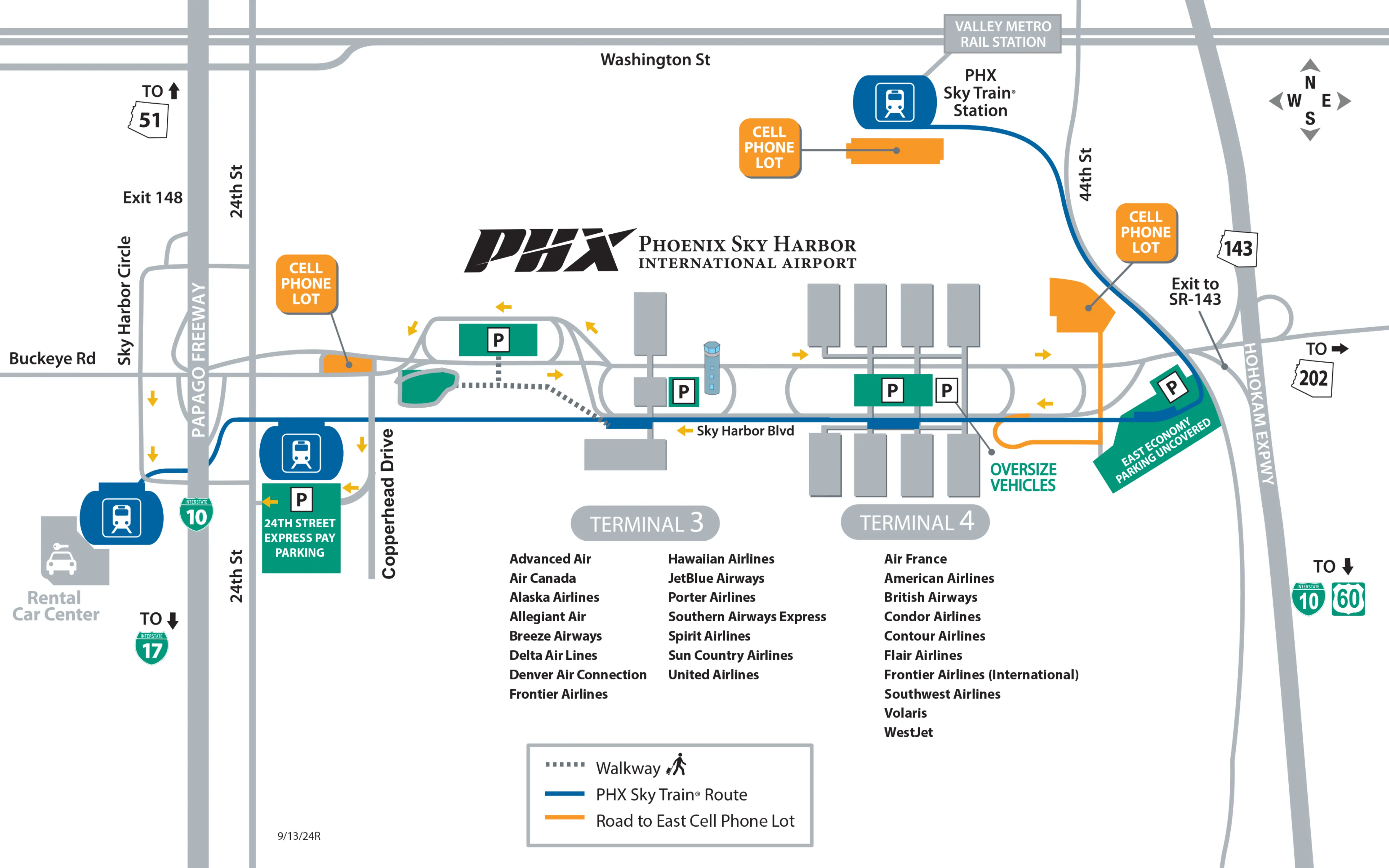
Archive Phoenix Sky Harbor International Airport Map
Below are all historical map versions for Phoenix Sky Harbor International Airport. Each year includes the official map available for that period, presented as both WebP and PDF.
2024 Phoenix Sky Harbor International Airport Map
2023 Phoenix Sky Harbor International Airport Map