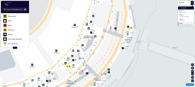
Philadelphia International Airport Terminal A Map (Most Up-To-Date)
PHL Terminal A is a long, split-footprint complex with two distinct concourses—A-East (linear pier) and A-West (hammerhead international gates)—linked by a central indoor connector. Within Philadelphia’s main airport hub, the secure (airside) side functions like one continuous building, but landside movement and international arrivals are less intuitive, especially when Customs flows push you toward A-East ground transportation.
Map Table
| Zone | Connection | Walk Time |
|---|---|---|
| A-East (Gates A2–A13) | A/B connector near Gate A1 | 2–6 min to A1 |
| A-West (Gates A14–A26) | A-East via central connector | 5–8 min (midpoint to midpoint) |
| A-West far gates (A24–A26 area) | Gate A1 (Terminal F shuttle) | 15–20 min |
| FIS / International Arrivals | Exit funnel toward A-East baggage / transport | 10–15 min from far A-West gates |
Philadelphia International Airport Terminal A Map Strategy
- Treat A-East and A-West as two different terminals connected by one long indoor spine; commit early to “A-East vs A-West” so you don’t lose time to backtracking.
- Default to checkpoint certainty over proximity; if your intended checkpoint looks constrained, reroute before you’re locked into the wrong lobby and curb frontage.
- Plan Customs as a two-part journey: processing in A-West, then a forced move toward A-East exits; stay with the signs for Terminal A-East baggage/ground transport even if it feels like you’re walking away from A-West.
- For rideshare, ignore the first curb and head straight for Zones 5–8 signage, then continue to Zone 7 on South Commercial Road to avoid the classic “driver can’t reach you” mismatch.
2026 Philadelphia International Airport Terminal A Map + Printable PDF
Terminal A’s layout in 2026 is still defined by the A-East vs A-West split, with international arrivals processing concentrated at A-West (FIS) and ground transportation interfaces clustered by A-East. Restroom upgrades completed in 2025 improved high-stress nodes (Customs Hall and A-East baggage claim), while the South Commercial Road zoning keeps rideshare pickups consolidated into Zone 7.

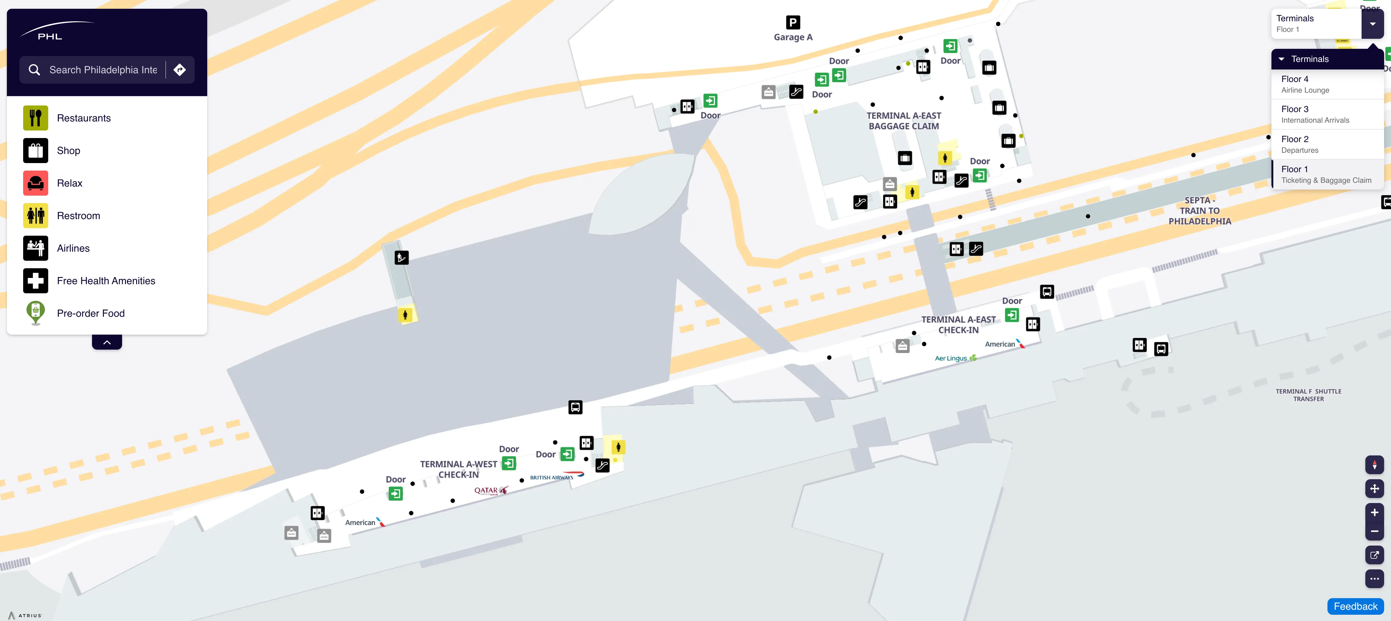
Philadelphia International Airport Terminal A Level 1 Ticketing Map 2025
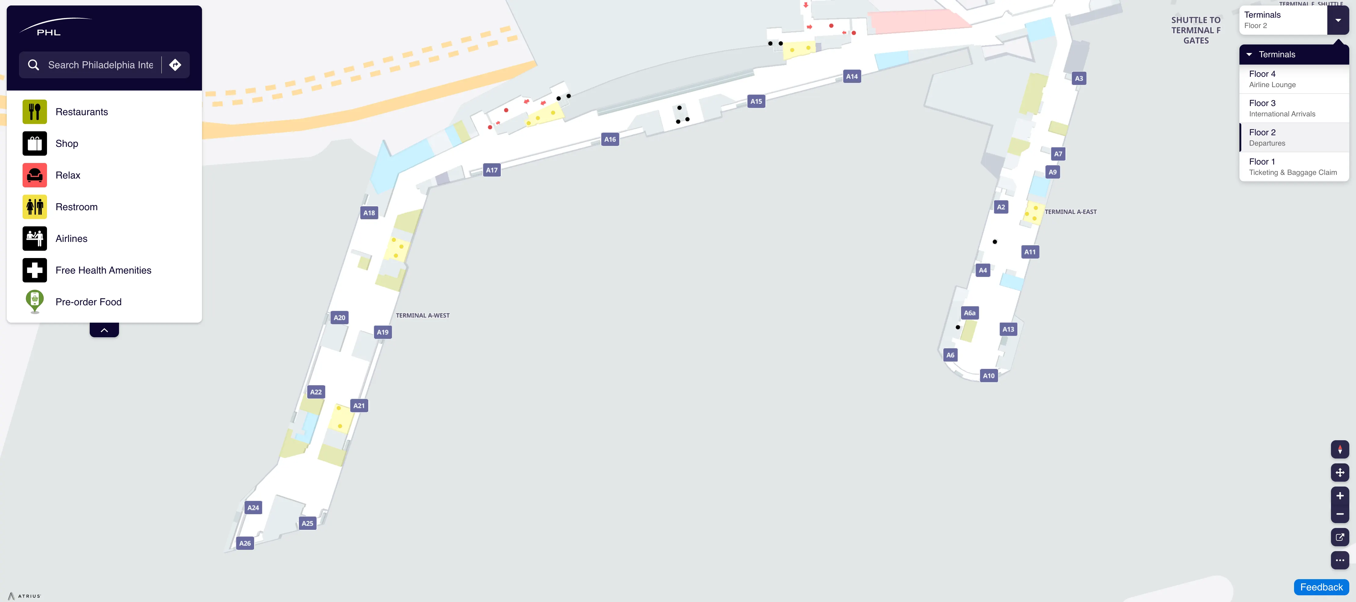
Philadelphia International Airport Terminal A Level 2 Departures Map 2025
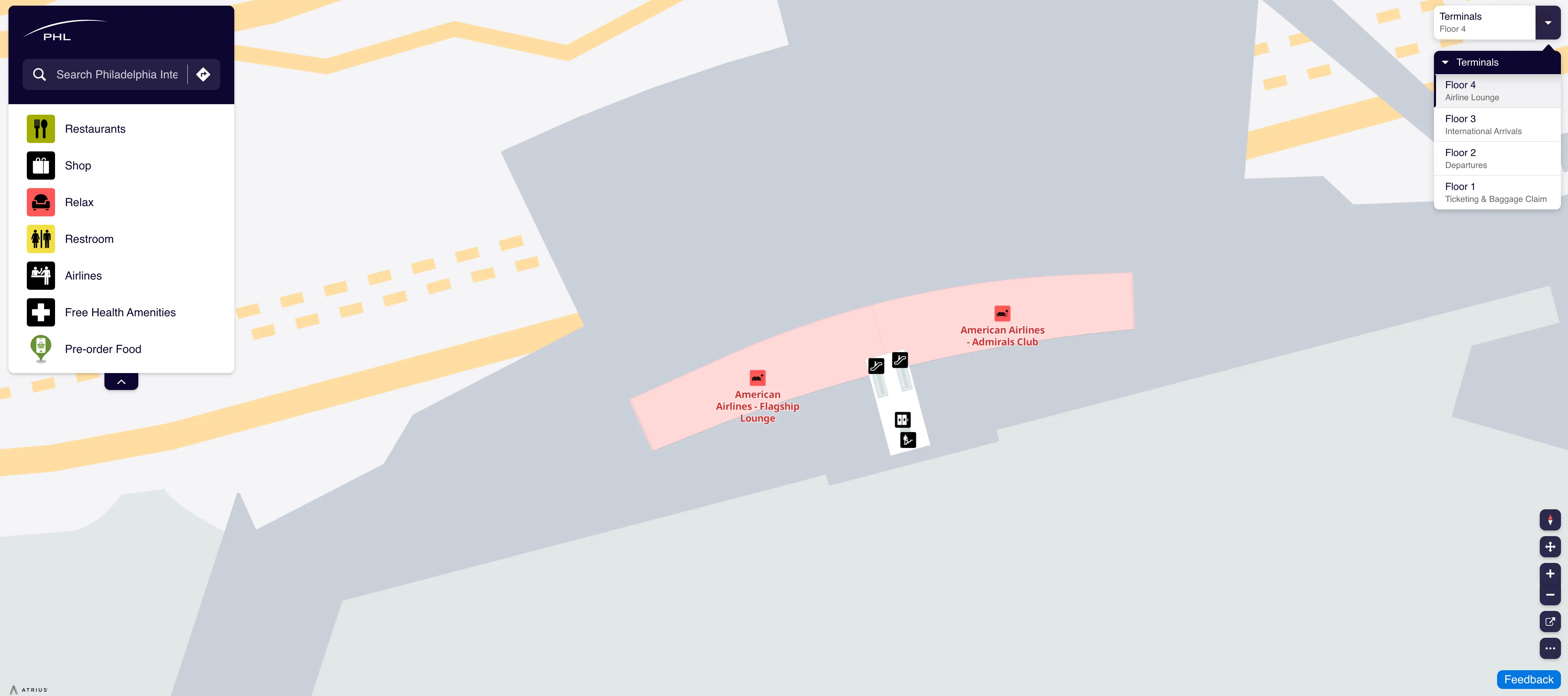
Philadelphia International Airport Terminal A Level 4 Airline Lounge Map 2025
2026 Philadelphia International Airport Terminal A Map Guide
What is the exact walking route (airside) from Terminal A-East gates to the Terminal A-West farthest gates, including the specific corridor transitions?
Walking stays fully airside on one continuous indoor connector, with the only true “transition” being the shift from A-East’s linear pier into the central connector spine, then out into A-West’s hammerhead gate hall.
From any A-East gate (A2–A13), walk toward the lower-numbered end of the concourse until you reach the A-East/A-B connector hub near Gate A1. Continue straight through the wide central connector that links A-East to A-West (you’ll pass the high-density connector node with services like the airside service animal relief area). Keep following overhead signs for Gates A14–A26 until the architecture opens into A-West’s hammerhead atrium; then stay on the main fork toward the highest gate numbers to reach the far international end (A24–A26 area).
Where is the exact airside shuttle stop used to move between Terminal F and the A/B connector area (pinpoint location relative to nearest gates)?
The airside shuttle stop is at Gate A1, positioned at the Terminal A-East end right where Terminal A meets the A/B connector hub.
From within the secure area, follow signs toward the A-East / Terminal B junction and walk to the Gate A1 seating area rather than into A-West. The stop functions as the A-side anchor for the Terminal F shuttle, so travelers coming from A-West far gates (A24–A26) must first walk the full A-West-to-A-East connector to reach Gate A1. On the Terminal F side, the matching stop is at Gate F10.
What is the exact landside (pre-security) walking path from Terminal A-West departures/check-in to the Terminal A-East security checkpoint entrance, including where the sidewalk begins and ends?
The landside walk uses the exterior Departures-level frontage sidewalk from the A-West check-in doors to the A-East TSA entrance doors. The sidewalk begins at the curbside canopy directly outside Terminal A-West departures/check-in and ends at the curbside canopy doors where the Terminal A-East security queue starts.
| Segment | Exact transition | Landmark anchor |
|---|---|---|
| A-West check-in → curb | Exit the A-West ticketing hall to Departures curb | Sliding doors outside A-West airline counters |
| Frontage walk (eastbound) | Stay on the covered Departures sidewalk under the canopy, walking “east” toward A-East | Continuous curb lane + overhead terminal letters on the building face |
| Approach A-East lobby | Pass the central connector frontage and continue until the A-East departures doors | Shift from A-West hammerhead frontage to A-East linear frontage |
| Sidewalk end → TSA entry | Enter the A-East departures doors and follow the interior queue line to the checkpoint mouth | TSA stanchions immediately inside A-East lobby doors |
What is the measured walking distance (in feet/meters) from Terminal A-East security exit to the far end of A-East (Gate cluster at the end)?
Walking distance is not provided as a measured feet/meters figure in the supplied audit, but the far end of A-East is functionally the highest gate-number cluster (A12–A13 area) at the terminal’s linear pier tip.
From the A-East security exit, stay in the post-security departures hall and follow overhead gate signs down the A-East concourse spine toward Gates A2–A13. The “far end” is reached when the concourse narrows into the last holdrooms serving the end cluster (A12–A13), with no further gate signage beyond that point. If you need a time proxy for planning, use the terminal’s linear-pier reality: it’s a straight walk with minimal decision points, but it feels long because there’s no alternate branch once you commit down the pier.
What is the measured walking distance from Terminal A-West security exit to the farthest A-West international gates?
A measured feet/meters distance is not specified in the audit, but the farthest A-West international gates are at the hammerhead tip in the A24–A26 area.
From the Terminal A-West security exit, enter the post-security A-West departures lounge and follow overhead signage for Gates A14–A26 (staying within the hammerhead concourse rather than drifting back toward the A-East connector). Continue straight through the main A-West atrium until the concourse forks deeper into the international gate pier; keep tracking the highest gate numbers to reach the far end. For planning, treat this as the longest A-West internal walk: the same “tip-of-pier” geography that makes Gate A26 the farthest reference point in Terminal A.
After exiting Customs/Immigration in Terminal A, what is the exact path to reach the ground transportation level, and where are the elevators/escalator barriers located on that route?
The route is a forced eastward move: Customs exit in A-West funnels you to elevators down, then directs you by signage to Terminal A-East baggage claim exits for all ground transportation zones.
After you clear CBP and pass the customs exit control, follow the “Exit/Baggage Claim/Ground Transportation” wayfinding to the elevator bank that drops you from the international arrivals processing level to the ground-floor public area. From the elevator lobby, continue following signs for Terminal A-East baggage claim and ground transportation, which keeps you moving toward the A-East exit complex rather than an A-West curb. The audit flags barrier friction here as an elevator-dependent flow (reported as “forced elevator routing” with escalator availability constrained), so when you hit the vertical-change point, assume elevators are the reliable path and don’t budget time around escalator-only shortcuts.
Where exactly is the rideshare pickup zone for Terminal A arrivals, and what is the step-by-step walking route from the Terminal A arrivals exit to the correct pickup point?
Rideshare pickup for Terminal A arrivals is at Uber/Lyft Zone 7 on South Commercial Road (the outer commercial roadway), not the first curb outside baggage claim.
Exit Terminal A arrivals into the public baggage claim frontage and orient to the doors signed for ground transportation Zones 5–8 (this is the South Commercial Road side). Go through those Zones 5–8 doors and do not stop at the inner curb where Zones 1–4 operate. Cross the inner Arrivals Road at the marked crosswalk to the pedestrian island and outer roadway. Once on the outer commercial side, follow the posted Zone numbers past the Zone 5/Zone 6 loading areas until you reach Zone 7. If your app shows Red Zone or Green Zone, use Zone 7 anyway—both color pickups map to the same physical Zone 7 footprint.
If Terminal A late-night exits are restricted, what is the exact detour path from Terminal A gates to the Terminal B exit corridor (note airside/landside transitions)?
The detour stays airside past the A-East/A-B connector hub, then switches to landside only when you exit through Terminal B. Terminal A curb exits can be effectively unavailable late at night, so plan to leave the secure area from B instead of hunting for a closed A door.
From any Terminal A gate, walk airside toward the A-East end and aim for the Gate A1 area (the A/B junction). Continue straight into the Terminal B concourse without re-clearing security (still airside), then follow overhead signs for Exit and Baggage Claim. At the Terminal B exit point, go through the exit doors (airside → landside transition) and follow the interior corridor down toward Terminal B baggage claim/curb doors to reach the B exit corridor.
Where are the closest restrooms to the Terminal A-East gate cluster most affected by reported leaks, and what is the shortest mapped route to reach them without backtracking?
The closest reliable restroom anchor called out in the audit is the newly renovated Terminal A-East baggage claim restroom, but that is landside and not suitable if you’re already airside near the A-East gate tip.
From the A-East gate cluster (A12–A13 end), the shortest “no backtracking” logic is to continue forward only until you hit the end, then reverse direction once and head toward the nearest central node rather than walking all the way back to the checkpoint. Walk back down the A-East concourse spine toward the connector side (lower gate numbers) until you reach the denser connector node area where services cluster (near the A-East/A-West connector and the Gate A1 hub), then use the nearest marked restroom there. If a leak area is blocking a section, take the opposite-side concourse lane and keep moving toward that connector node instead of trying to cut across closed holdroom edges.
What is the shortest mapped route from Terminal A baggage claim to the nearest SEPTA Airport Line station entrance, including which doors/corridors to use?
The nearest rail access is the SEPTA Airport Line entrance signed for “Terminal A (East),” reached from Terminal A-East baggage claim via the ground transportation side and then up to the pedestrian bridge level to the center platform.
From Terminal A baggage claim, walk to the Terminal A-East public exit area and follow signs toward Ground Transportation / South Commercial Road (Zones 5–8). Look for the SEPTA Airport Line / Regional Rail wayfinding near that exit zone and enter the SEPTA lobby access point (typically an elevator/escalator up from the baggage claim level). Go up to the pedestrian bridge level and follow the enclosed walkway to the long shared platform area that serves Terminals A and B, defaulting to the center platform boarding area unless on-site signage indicates otherwise.
What is the shortest mapped route from Terminal A-West gates to the nearest open food option cluster (by location), minimizing backtrack distance?
The closest food cluster to Terminal A-West gates is the A-West hammerhead atrium concessions zone near the main gate hall, where multiple options are grouped together.
From the A-West gate area (A14–A26), walk toward the central A-West atrium rather than backtracking all the way into the A-East connector. Stay within the hammerhead departures lounge and follow overhead signs toward the main concessions node, where you’ll hit the densest grouping of outlets serving A-West gates. This is the lowest-backtrack option because it keeps you inside A-West’s primary “gravity well” instead of committing to the long connector spine toward A-East and the A/B junction. For late hours, prioritize the core A-West concessions cluster and nearby vending banks before you start the longer walk toward Gate A1.
Where are the exact choke points (narrow corridors/sharp turns) on the airside walk between F and A, and what alternate mapped path avoids them if possible?
Choke points concentrate in the connector chain between the A/B hub and the B–C food court connector, where passenger density and turning movements spike, and again in the D–E complex transitions where flows merge from multiple concourses.
From Terminal F, the long airside walk runs F → D/E complex → Terminal C → B–C connector (food court) → Terminal B → A/B connector → Gate A1/A-East. The narrowest-feeling zones are typically the connector “throats” where two concourses feed one corridor and where food/retail islands force sharper weaving around corners. The alternate path is operational, not geometric: use the airside shuttle (Gate F10 ↔ Gate A1) to bypass the entire high-density connector chain rather than trying to route around it on foot. If you must walk, keep to the outer wall edge through connector turns to avoid the centerline bottleneck near storefront pinch points.
What is the measured walking distance from the A/B connector to the Terminal A-East security checkpoint (useful when A-West checkpoint is closed)?
A measured feet/meters distance from the A/B connector to the Terminal A-East security checkpoint is not specified in the audit. The practical routing is a short, direct landside reposition from the A/B junction area toward the A-East departures lobby doors where the TSA queue begins.
| Route segment | Corridor transition | Landmark anchor |
|---|---|---|
| A/B connector → A-East frontage | Move landside toward Terminal A-East departures | Gate A1 area as the A-side reference point |
| A-East frontage → A-East lobby | Enter A-East departures doors | A-East curbside canopy + terminal letter signage |
| Lobby → checkpoint mouth | Follow stanchions/queue to TSA entry | TSA queue line immediately inside A-East lobby |
What is the measured walking distance from the A/B connector to the Terminal A-West security checkpoint (for the ‘which checkpoint is closer’ decision)?
A measured feet/meters distance from the A/B connector to the Terminal A-West security checkpoint is not specified in the audit. The functional reality is that A-West is the longer reposition because you must traverse the full A-East ↔ A-West connector spine before you even reach the A-West departures lobby.
From the A/B connector hub near Gate A1, move toward Terminal A and continue through the A-East side toward the central indoor connector that links A-East to A-West. Stay on that connector until you reach the A-West departures lobby frontage above the A-West ticketing hall, then enter the A-West checkpoint queue. For “closer checkpoint” decisions, treat A-East as the near option from the A/B hub and A-West as the far option unless you’re already physically staged in the A-West landside lobby.
Where exactly are the baggage carousels serving Terminal A arrivals, and what is the shortest mapped path from Gate Axx to the correct carousel area?
Terminal A baggage claim carousels are clustered in the public Terminal A-East baggage claim hall, which is also where international “forced migration” flows emerge after clearing A-West Customs and taking elevators down.
From a Terminal A gate, follow signs for Baggage Claim/Arrivals and stay with the main passenger exit stream toward the central terminal core. If arriving internationally at A14–A26, you will be diverted into the sterile corridor to the FIS facility first; after CBP and baggage pickup inside FIS, follow the exit flow to the elevators down and then the signage directing you to Terminal A-East baggage claim. If arriving domestically, exit the secure area by following the standard Arrivals/Baggage Claim signs down to the Terminal A baggage claim level, then walk toward the A-East baggage claim hall where the carousel banks are located and where the primary ground transportation exits (Zones 5–8) are posted.