Ottawa Macdonald-Cartier International Airport Map (Most Up-To-Date)
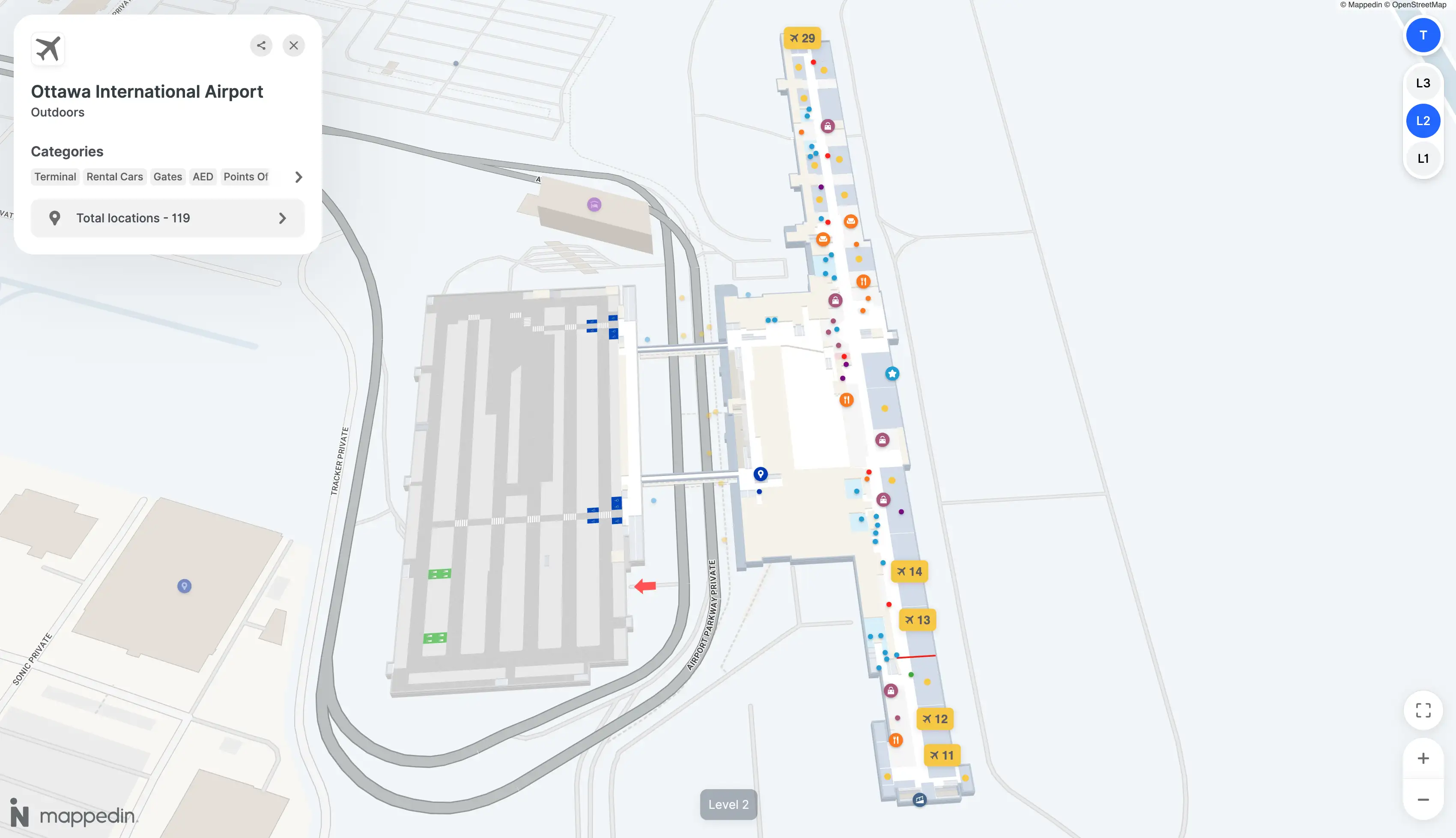
Ottawa Macdonald-Cartier International Airport is a three-level, single-building terminal with a long, crescent-shaped airside concourse and a hard split between Domestic/International gates and the United States preclearance wing. Within Ottawa’s primary airport hub, the biggest navigation risk is vertical: Arrivals on Level 1, screening/check-in on Level 3, and gates on Level 2—plus a sealed United States zone that behaves like a separate terminal.
Map Table
| Level Stack | Gate Zones | Security Split | Key Landmark |
|---|---|---|---|
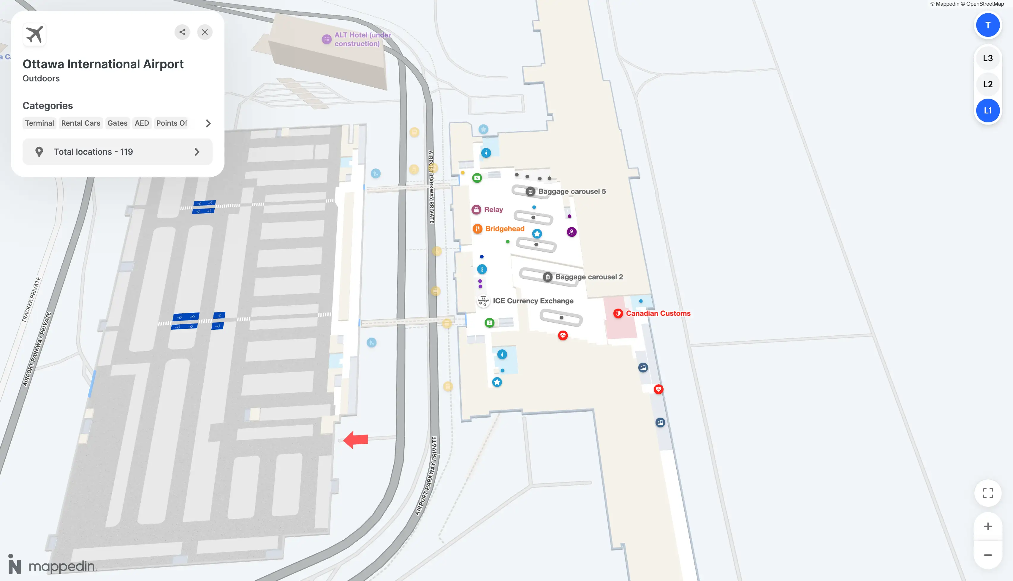
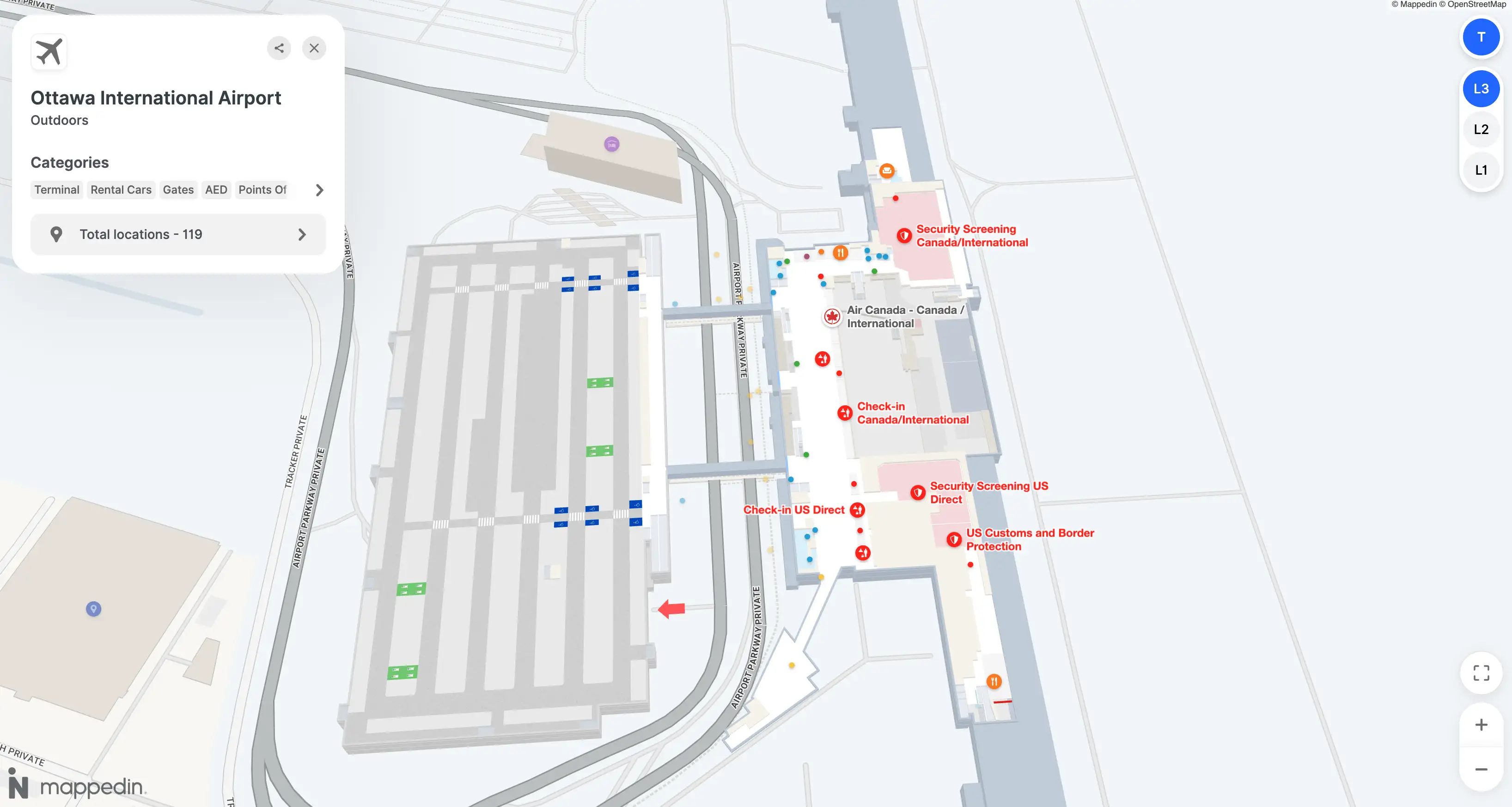
| Level 1 Arrivals / curb | Gates 1–12 United States | Right channel → United States CBP | Post 15 |
| Level 2 Gates / holdrooms | Gates 13–28 Domestic/International | Left/center → Domestic/International | Gate 12/13 barrier |
| Level 3 Check-in / CATSA | Single terminal hall | Single checkpoint, bifurcation post-doc check | Oversize drop far-left |
Ottawa Macdonald-Cartier International Airport Map Strategy
- Treat United States preclearance as a one-way border inside the building: once you commit to the United States channel, you’re locked into Gates 1–12 with no access back to Canal Market Hall.
- For Domestic → United States connections, assume an “exit to enter” loop: Level 2 arrival → Level 1 public hall → Level 3 screening → back down to Level 2 United States gates.
- Calibrate your walks using the true end-to-end span: Gate 28 to Gate 1 is close to a kilometer of motion when the landside detour is required.
- If you need an accessible route, hunt for the elevator immediately after screening before you get pulled into the escalator flow; missing that decision point creates wrong-level stress fast.
2026 Ottawa Macdonald-Cartier International Airport Map + Printable PDF
Current operations at 2026 still follow the same “layer-cake” flow: Level 3 processing feeds Level 2 gates, while Level 1 remains the only landside mixing zone for arrivals, baggage, and ground transport. The United States transborder area stays physically sealed from Domestic/International, so any Domestic arrival connecting to a United States departure should plan for a full landside loop and re-screening.
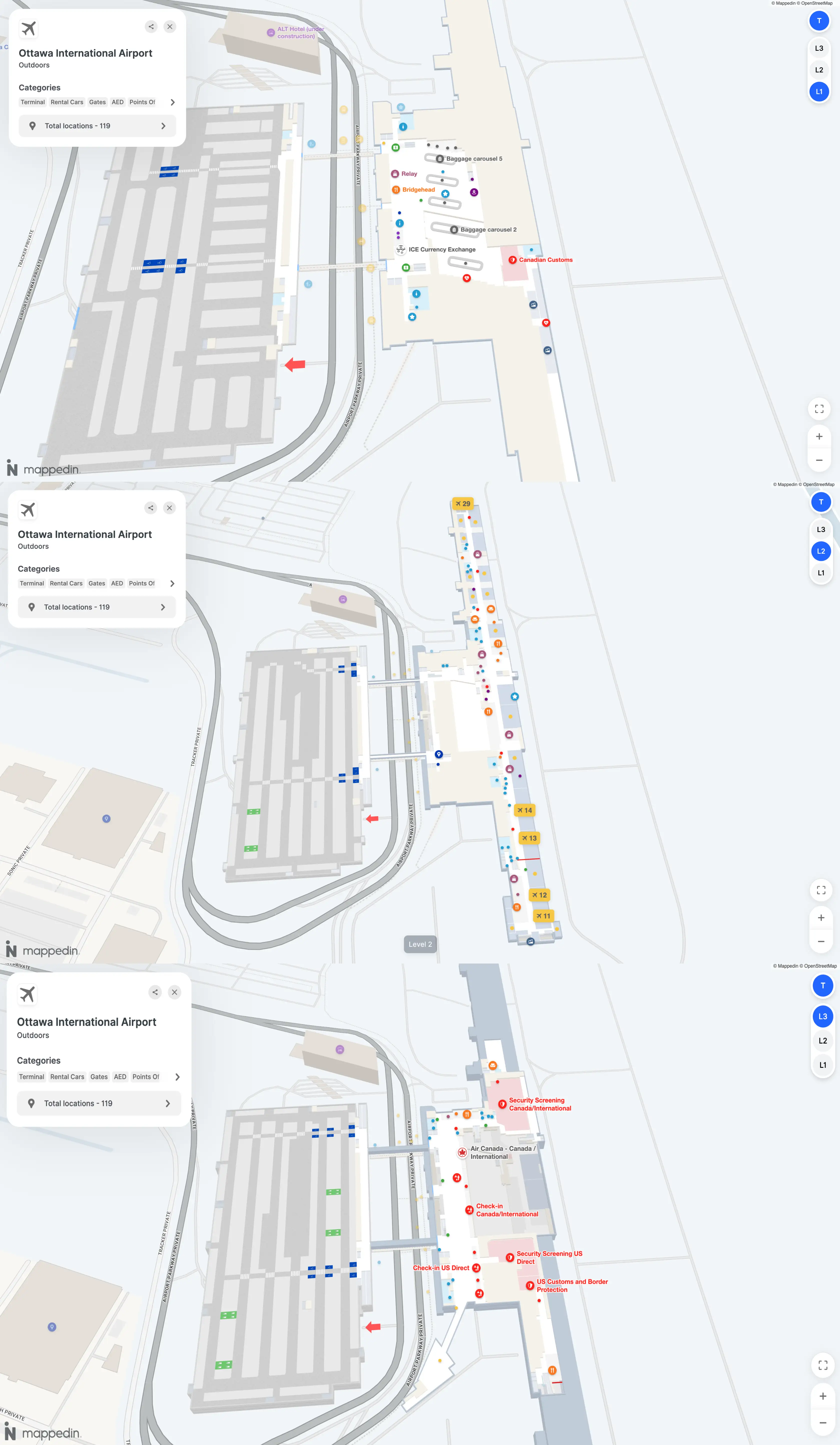
Ottawa Macdonald-Cartier International Airport Level 1 Map 2026
Ottawa Macdonald-Cartier International Airport Level 2 Map 2026
Ottawa Macdonald-Cartier International Airport Level 3 Map 2026
2026 Ottawa Macdonald-Cartier International Airport Map Guide
What is the exact walking time (minutes) from Domestic arrivals exit to the US Departures security entrance at Ottawa Macdonald-Cartier International Airport (including the level change)?
Walking takes about 11–15 minutes of motion time from the Domestic arrivals exit to the United States departures security entrance when you include the required down-and-up level change.
The route is forced landside: exit the Domestic/International secure concourse on Level 2 via the central “Sortie/Exit,” go down to Level 1 (Arrivals/Baggage hall), cross the public hall to the central vertical core, go up to Level 3 (Check-in), then walk to the United States departures security entrance at the south end of the hall. Gate position drives the range: a near-central domestic gate trends closer to 11 minutes; an outer gate can push it toward 15.
What is the exact walking distance (meters) from the farthest domestic gate to the farthest US preclearance gate area inside Ottawa Macdonald-Cartier International Airport?
No airside corridor exists between the Domestic/International gates and the United States preclearance gates, so the “farthest-to-farthest” connection distance is an operational detour rather than a single continuous airside walk.
| Endpoint Pair | Path Type | Walking Distance |
|---|---|---|
| Gate 28 (Domestic/International) → Gate 1 area (United States) | Operational path via landside + re-entry | ~800–900 m |
| Gate 28 → Central elbow (near the security feed) | Airside spine segment | ~350 m |
| Central elbow → Gate 1 area | United States wing segment (post-preclearance side) | ~250–300 m |
Where is the closest elevator to the main security checkpoint that takes you down to the departure gates level (accessible route)?
The closest elevator is immediately after the screening equipment on Level 3, positioned beside the main escalator bank that drops into the secure Level 2 concourse.
After you clear the body scanner/metal detector and collect items at the belt, stop before you get funneled toward the “grand” escalators. The elevator doors are adjacent to that escalator bank at the post-security decision point, and it takes you down to Level 2 near the central retail hub (Domestic/International side) or the United States holdroom entry area depending on which channel you used after the document check. If you pass the escalator precipice, doubling back is awkward because security flow is one-way.
What is the exact walking distance (meters) from the Oversize Baggage desk to the main security queue entrance?
Walking is about 75–100 meters from the Oversize Baggage drop to the main CATSA security queue entrance on the check-in level.
The oversize drop sits at the far left extremity of the Level 3 check-in counter islands (relative to standing in the hall facing the counters). The security queue entrance is centered on the same level, so the path is a straight cross-hall traverse from the counter ends back toward the middle, cutting across the open check-in floor where other passengers are joining airline lines. The distance is short, but congestion is what usually slows it down.
Where is the Park’N Fly / offsite shuttle pickup point relative to the Arrivals doors (door number / curb zone)?
The Park’N Fly and other offsite shuttles pick up outside the Arrivals level at Post 15 on the curb.
Post 15 is the key curbside locator on Level 1 and functions as the commercial shuttle zone, separated from the busiest private pickup area. From the baggage claim exit doors, the walk to Post 15 is roughly 100–150 meters along the curb line to the far end of the arrivals frontage. Use the numbered post itself as the landmark rather than a door number, since doors cluster near the center while Post 15 anchors the shuttle stand area.
What is the exact walking distance (meters) from Long-Term Parking to the Departures entrance using the shortest route?
Walking is about 150–300 meters from Long-Term Parking to the Departures entrance when you use the parkade’s pedestrian bridge into the Level 3 terminal.
The shortest route is parking in the Long-Term (P4) section that connects into the main parking structure, walking to the enclosed pedestrian bridge, crossing the bridge over the loop road (about 50 meters), then continuing into the Level 3 check-in/departures hall. Spot location inside the structure drives the spread (closer stalls land near ~150 meters; deeper stalls push toward ~300 meters). Some surface long-term sections can be farther, trending toward roughly 600 meters.
Where is the NEXUS/priority lane located at the main security screening (which side/entrance position)?
The NEXUS (Verified Traveller) lane is positioned on the far side of the Level 3 security checkpoint array, typically on the right-hand side when you are facing the screening entrance.
At Ottawa Macdonald-Cartier International Airport’s main CATSA checkpoint, the priority lane functions as a bypass of the longer document-check and queue “snake,” feeding you toward the same screening hardware used by general passengers. Look for Verified Traveller/NEXUS signage at the outer edge of the checkpoint lanes rather than in the center of the main queue mouth. Lane placement can shift with staffing, but it remains an edge-positioned entry channel rather than a middle lane.
At what exact point (landmark on the security layout) does the NEXUS lane merge into the regular screening flow?
The NEXUS (Verified Traveller) lane merges into the regular flow at the divestment station immediately before the X-ray belt and body-scanner entry.
At Ottawa Macdonald-Cartier International Airport’s main Level 3 checkpoint, the priority lane usually skips the long queue but does not keep a fully separate set of screening machines. The practical “merge landmark” is where passengers begin loading bins—right at the front of the belt area—because that is where all lanes funnel toward the same scanner hardware. If the Verified Traveller lane is operating, you reach the bin-loading zone faster; once you hit the divestment tables, you are effectively in the same throughput bottleneck as everyone else.
What is the exact walking time (minutes) from US preclearance exit to the nearest food option inside the US holdroom area?
Walking takes about 1 minute from the United States preclearance exit to the nearest food option inside the United States holdroom area.
From the exit of the CBP preclearance booths, the nearest option is typically the Tim Hortons counter in the Gates 1–12 zone. The distance is under 50 meters, so the motion time is about 30–60 seconds at a normal pace. The bigger constraint is selection: once you clear preclearance, you’re locked into the Gates 1–12 sterile area with limited amenities and no access to the Canal Market Hall on the Domestic/International side.
What is the exact walking time (minutes) from baggage claim exit to the Arrivals pickup curb using the shortest path?
Walking takes less than 1 minute from the baggage claim exit to the Arrivals pickup curb on Level 1.
From the carousel area, use the nearest “Sortie/Exit” revolving doors; the curb is immediately outside along the same frontage. The shortest path is essentially a straight line from the belt to the closest door, then a step-out to the pickup curb. Typical distance is about 20–40 meters, so even with a roller bag it’s usually under a minute.