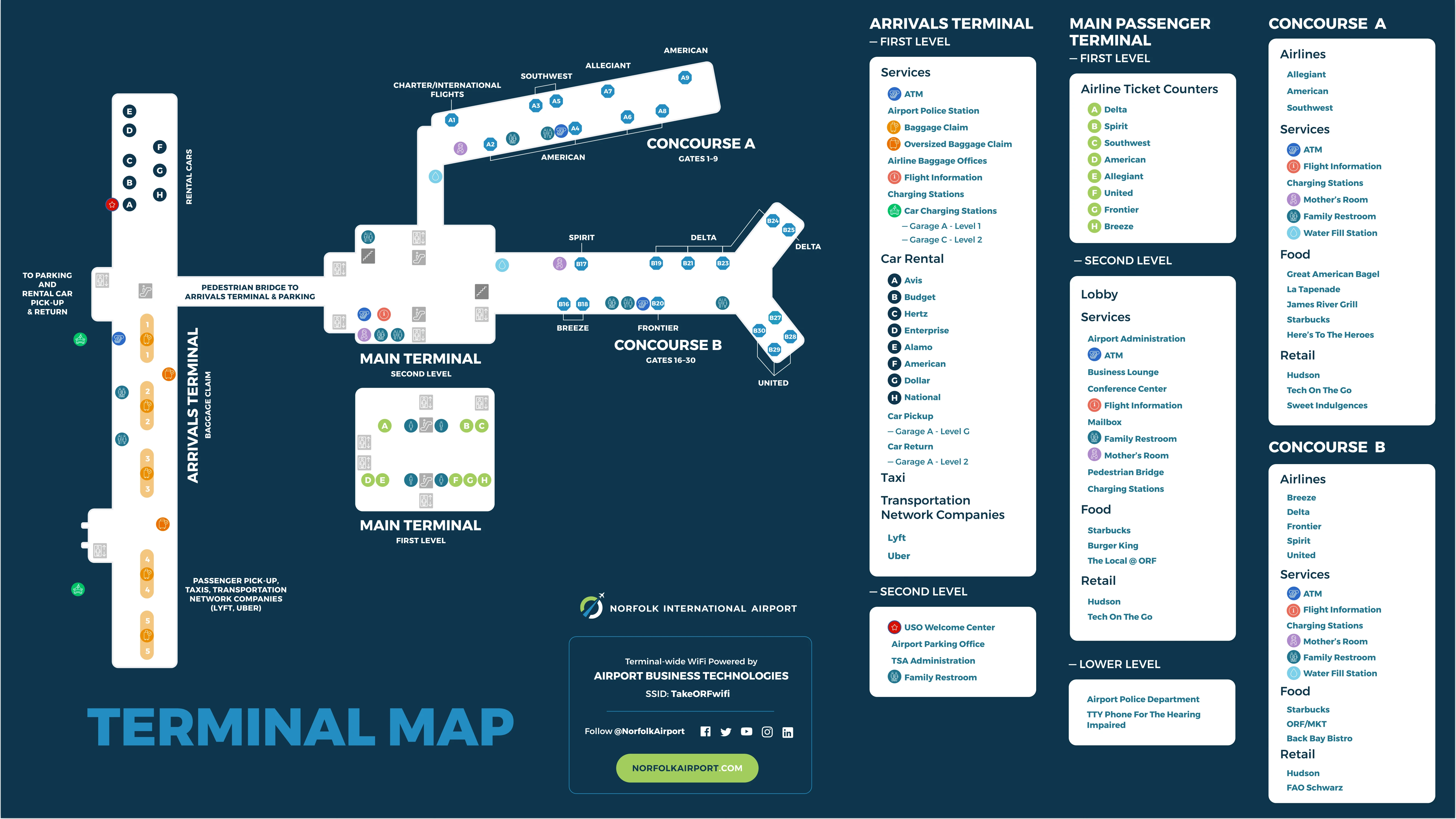
Norfolk International Airport Main Passenger Terminal Map (Most Up-To-Date)
Norfolk International Airport’s Main Passenger Terminal is a split-level departures-focused building with a central public atrium and two concourses (A and B) extending airside. Landside, the big orientation cue is the elevated, climate-controlled pedestrian bridge that links this terminal to the separate Arrivals/Baggage Claim building across the road loop. Within Norfolk’s primary airport hub grounds, most “where do I go next?” decisions happen at the Level 2 lobby spine: TSA entries, concourse entry, and the bridge throat.
Map Table
| Level | Core areas | Direct connections | Key landmarks |
|---|---|---|---|
| Level 1 | ticketing lobby, check-in counters | elevators to Level 2 | north departures elevators, south departures elevators |
| Level 2 | main lobby atrium, TSA checkpoints, concourse access | pedestrian bridge to Arrivals mezzanine | business lounge, information center, Hudson News |
| Concourse A | gates, holdrooms | return to Level 2 lobby | concourse junction |
| Concourse B | gates, holdrooms | return to Level 2 lobby | distal gates, long walk axis |
Norfolk International Airport Main Passenger Terminal Map Strategy
- Treat the pedestrian bridge as a door-to-door route, not a vague connector: Main Terminal Level 2 atrium throat (by the lounge/info/retail core) → Arrivals Mezzanine Level 2 (by the USO/Parking Office node) → elevator/escalator bank down to baggage claim.
- For curb pickups, plan to meet at Arrivals Level 1 by a specific door/zone label, not “outside baggage claim,” and default to the Park & Wait workflow to avoid looping confusion.
- From parking, bias routes that stay inside and minimize vertical changes: pick the garage/elevator core that lands you closest to the bridge level and the Level 2 atrium spine (TSA and concourse entry).
- Assume a pedestrian-network dead end outside the terminal loop: do not plan a “walk to public sidewalks” exit unless you are willing to backtrack to a verified continuous sidewalk connection point off-airport.
2026 Norfolk International Airport Main Passenger Terminal Map + Printable PDF
Current 2026 navigation still revolves around the landside bridge transfer: Departures/Main Terminal Level 2 ↔ Arrivals Mezzanine Level 2 across a 362-foot span. The moving-walkway fix (pit-less modular units along the bridge sides) is treated as an operational comfort upgrade tied to the Transform ORF modernization cycle, so the “long bridge walk” remains the map’s primary planning variable for arrival pickups, Garage D access, and baggage-claim transfers.
2026 Norfolk International Airport Main Passenger Terminal Map Guide
What is the exact walking distance from the farthest Concourse B gate to the first baggage-claim carousel (shortest pedestrian route)?
Walking is about 1,812 feet (≈552 meters) from the farthest Concourse B gate (Gate B30) to baggage claim (shortest practical indoor route to the carousel zone). The shortest path runs Gate B30 → Concourse B corridor to the secure exit/rotunda → across the Main Terminal Level 2 atrium to the pedestrian-bridge entrance → cross the 362-foot bridge → continue on the Arrivals Mezzanine to the elevator/escalator bank → descend to Level 1 and enter the carousel hall. Using the “first carousel” instead of the farthest carousel trims only a small portion at the end of the route; the distance driver is the Concourse B pier plus the bridge span.
Where does the pedestrian bridge route from Departures/Main Terminal → Arrivals/Baggage Claim begin and end (exact doorway/landmark endpoints)?
The pedestrian bridge begins at the Main Passenger Terminal’s Level 2 central atrium connection point and ends at the Arrivals Terminal’s Level 2 mezzanine connection point above baggage claim. On the Departures side, the bridge throat feeds into the Level 2 lobby flow beside the terminal’s commercial/service core, aligned with the area containing the Business Lounge, Information Center, and retail such as Hudson News. On the Arrivals side, the bridge terminates on the mezzanine level by the USO Welcome Center and the Airport Authority Parking Offices, immediately upstream of the elevator/escalator bank down to Level 1 baggage claim.
Where are the ADA-compliant elevator/ramp routes that avoid stairs between Arrivals/Baggage Claim and Departures/Main Terminal (exact access points)?
The ADA-compliant route uses the Arrivals Terminal elevator core between Level 1 baggage claim and the Level 2 mezzanine bridge landing, then stays level across the pedestrian bridge to the Main Terminal Level 2 atrium, and finally uses the Departures North or Departures South elevator cores to reach Level 1 ticketing/check-in if needed. From baggage claim, the step-free access point is the elevator bank that serves the Arrivals Mezzanine (the same vertical core reached from the mezzanine near the USO Welcome Center and Airport Authority Parking Offices). On the Departures side, the step-free access points are the two redundant elevator locations built into the north and south departure lobbies, linking Level 1 ticketing to the Level 2 main lobby/bridge level without stairs.
Where exactly are the moving walkway footprints (or planned replacement locations) on the pedestrian bridge—the precise start/end points along the bridge span?
The moving walkways are configured as side-aligned units along the pedestrian bridge, running essentially the length of the 362-foot enclosed span between the Main Terminal Level 2 atrium bridge throat and the Arrivals Mezzanine Level 2 bridge landing. The replacement concept is a split system placed along both sides of the bridge to preserve a wide center walk lane, so the “footprint” to verify on a map is the bridge corridor itself, from the comb-plate start area immediately after each bridge doorway to the comb-plate end area immediately before the opposite bridge doorway. The practical wayfinding endpoints remain the same: Departures bridge entry by the Level 2 atrium retail/service core, and Arrivals bridge entry by the mezzanine node near the USO/Parking Office area.
What is the shortest indoor walking route from Garage D to the TSA checkpoint entrance (distance in feet/meters)?
Walking is about 1,212 feet (≈369 meters) from a remote spot in Garage D to the TSA checkpoint entrance using the shortest mostly-indoor bridge-level route. The shortest path runs from Garage D to its elevator core → down to the bridge-connection level → through the Garage D connector into the Arrivals Mezzanine → across to the pedestrian-bridge entrance → cross the 362-foot bridge → continue through the Main Terminal Level 2 atrium to the TSA queue/entry point. The distance is driven by three linear pieces: the Garage D internal walk to elevators, the mezzanine/connector segment to the bridge, and the bridge plus the Level 2 atrium traverse to the checkpoint.
Which parking garage has the most direct door-to-door path to Baggage Claim (minimizing stairs and outdoor segments)?
Garage D has the most direct door-to-door path to Baggage Claim because it sits on the Arrivals-side campus and connects into the Arrivals building via the mezzanine/connector network with elevator access. The most stair-avoiding path is Garage D elevator core → Arrivals-side connector/mezzanine → elevator down to Level 1 baggage claim, staying covered and using elevators instead of escalators. By contrast, garages oriented toward the Departures/Main Terminal typically force a bridge crossing or longer lobby traverses to reach the Arrivals baggage hall, adding the 362-foot bridge span and extra wayfinding steps.
Where is the Park & Wait Lot entrance on the terminal road loop (the exact turn-in point relative to Arrivals/Departures approaches)?
The Park & Wait Lot entrance is at the realigned main entrance intersection where Norview Avenue meets the airport’s terminal access/loop approach, before you commit to the Arrivals/Departures curbside lanes. The turn-in is positioned as an early “buffer” option off the main entrance feed, so drivers can peel into the lot at the Norview Avenue–airport loop junction instead of entering the curbside circulation and trying to hold position near the Arrivals doors. On the loop logic, it functions as the pre-terminal decision point: take Park & Wait at the entrance intersection, then re-enter and follow signs to Arrivals or Departures only when your pickup is ready.
What is the exact walking distance from the Park & Wait Lot to the Arrivals curb pickup doors (shortest marked path)?
No marked pedestrian walking distance is available as a reliable “shortest path” because the airport’s landside layout is vehicle-first and the audit confirms a sidewalk connectivity break (“sidewalk void”) around the terminal road system. In practice, the Park & Wait Lot is designed for drivers to wait in their vehicles and then drive to the Arrivals curb when called, not to park and walk. If you attempt it anyway, the controlling constraint is not straight-line length but the lack of a continuous, ADA-safe, signed pedestrian route across/along the loop to the Arrivals doors, which makes “shortest marked path” effectively undefined for planning.
Where is the rideshare pickup zone located relative to Arrivals (exact curb/door/zone label a traveler must reach)?
The rideshare pickup zone is on Level 1 at the Arrivals Terminal in the Ground Transportation area, under/along the garage-covered curbside lanes. The correct target is the commercial/ground-transport curb (outer lanes used by taxis and rideshares), not the inner “Passenger Loading Zone” curb intended for quick private pickups. To triangulate on-site, route yourself from baggage claim to the Level 1 exits signed for Ground Transportation (rideshare/taxi), then walk out to the covered commercial curb where vehicles stage in the outer lanes beneath the garage structure.
Where is the airline baggage service / lost-baggage office located relative to the carousels (exact position and nearest carousel/exit)?
The airline baggage service (lost-baggage) offices sit along the perimeter walls of the Level 1 baggage-claim hall, not in the middle of the carousel area. The easiest anchor is the carousel numbering: low-cost carrier baggage-service desks are positioned toward the ends of the hall near Carousels 1 and 5, while major-carrier service points tend to be closer to the central carousel assignments. From the pedestrian bridge/elevator arrival into baggage claim, the quickest “map check” is to look along the outer wall line for the airline baggage-service signage and then align to the nearest carousel number and the closest exterior exit doors from the claim hall.
What is the nearest safe pedestrian exit path from the terminal to a continuous sidewalk on the public roadway network (first “safe sidewalk” connection point)?
No safe, continuous, ADA-compliant pedestrian exit path exists from the terminal complex to the public sidewalk network at Norview Avenue, so there is no “first safe sidewalk” connection point you can reach by a verified continuous route. The campus-style terminal loop breaks pedestrian infrastructure, and the remaining edges force people onto grassy shoulders or roadway margins to try to reach off-airport streets, which is the negative constraint to plan around. The only reliable “walk” option is staying inside the airport campus (terminal ↔ garages via elevators/bridge/mezzanine); for leaving the property to reach public sidewalks, default to a vehicle connection rather than attempting an on-foot route.
Archive Norfolk International Airport Main Passenger Terminal Map
Below are all historical map versions for Norfolk International Airport. Each year includes the official map available for that period, presented as both WebP and PDF.
2023-2026 Norfolk International Airport Main Passenger Terminal Map (Official 2023 Edition)