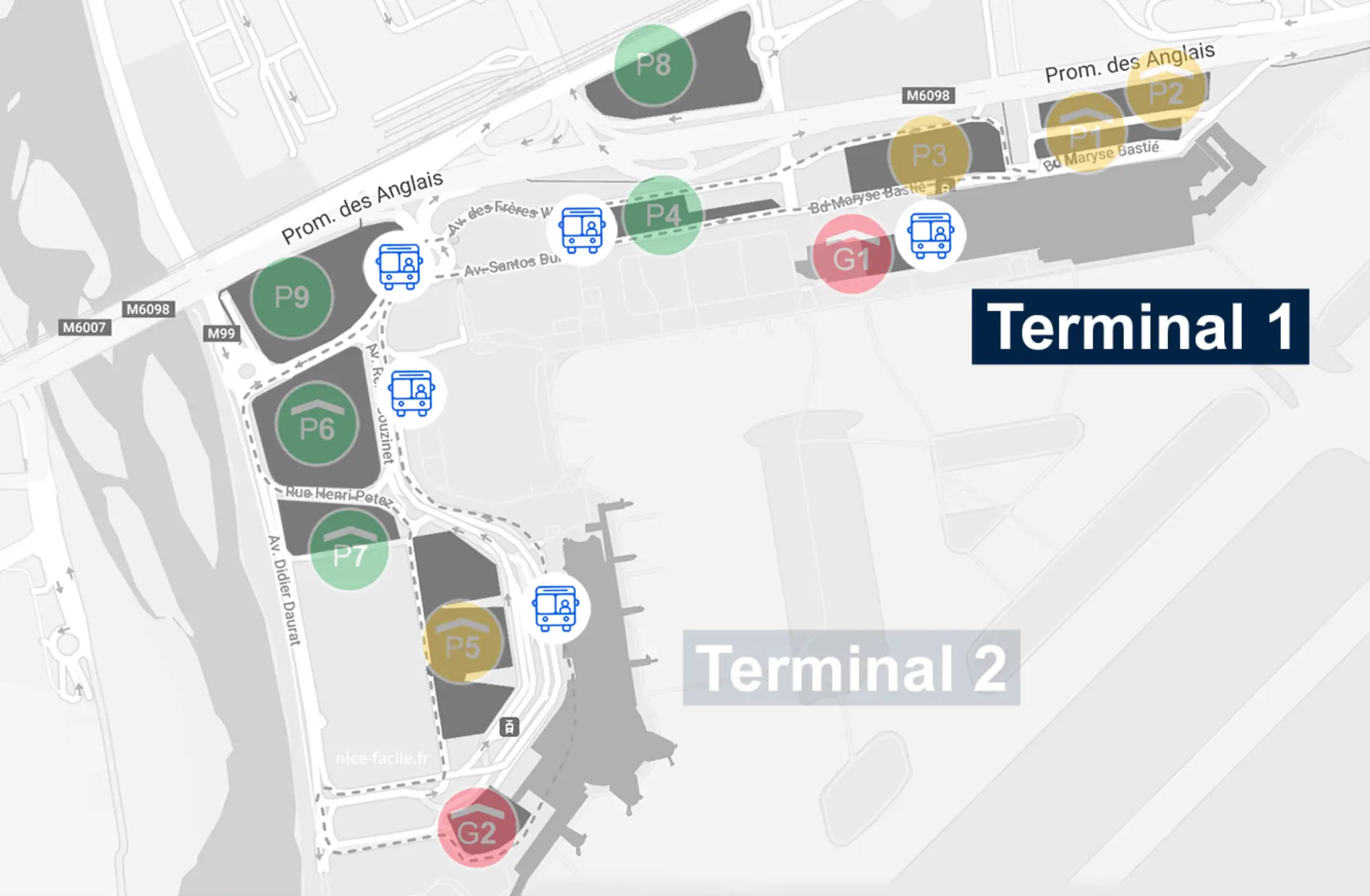
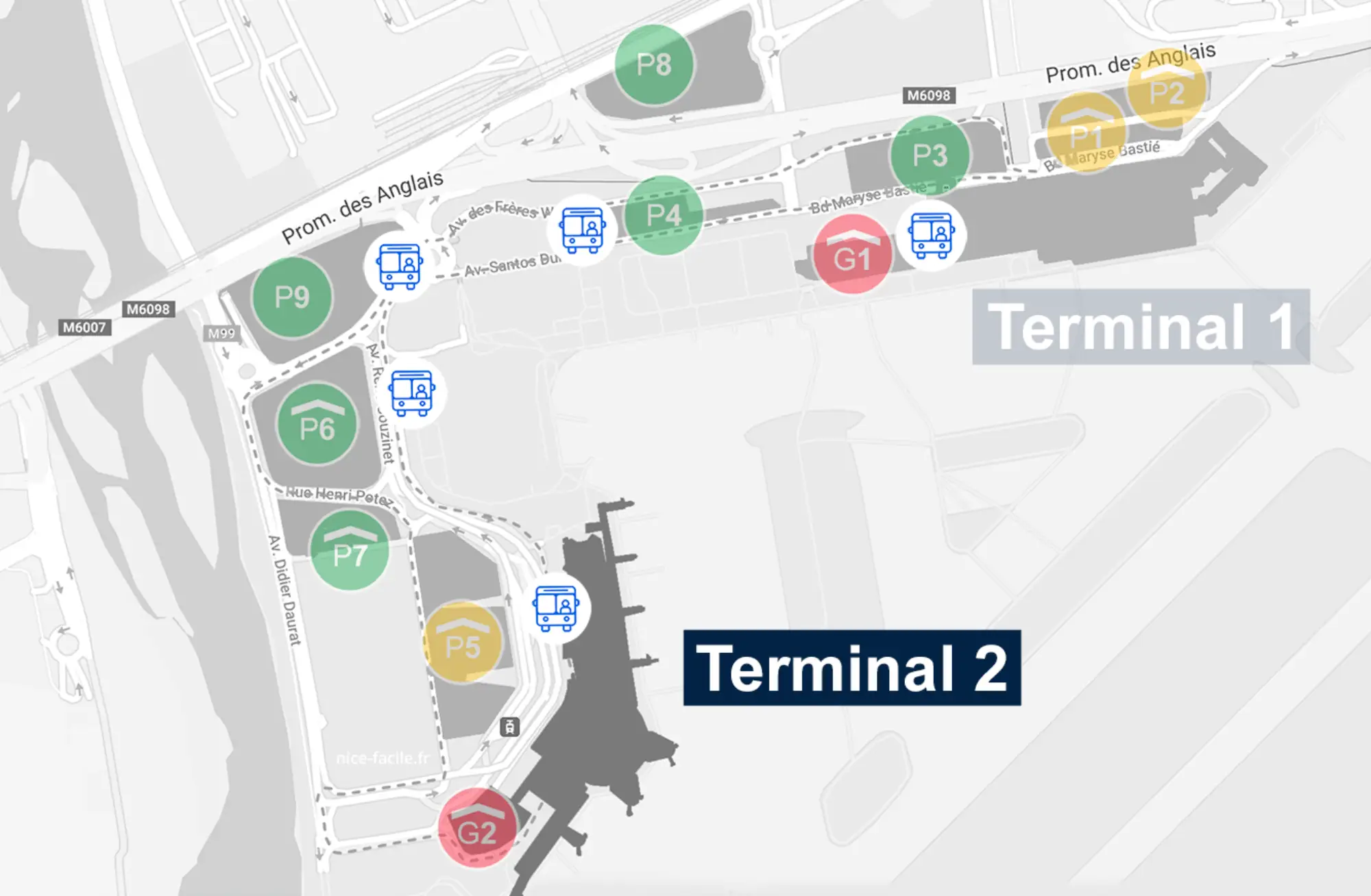
Nice-Côte d’Azur Airport Map (Most Up-To-Date)
Nice Côte d’Azur Airport is a two-terminal campus stretched along a linear frontage: Terminal 1 and Terminal 2 sit west–east with roadways and public transport running parallel, so most “wrong turns” happen when you pick the wrong level (Arrivals vs Departures) or the wrong curb. Within the Nice airport complex, the site runs on strict vertical separation—Arrivals at ground level and Departures above—plus a tramway link that looks simple on paper but has hard fare boundaries at Grand Arénas.
Map Table
| Terminal | Key Airlines | Primary Function | Transfer Mode |
|---|---|---|---|
| Terminal 1 | mixed carriers | passenger processing | Tram Lines 2/3, shuttle bus |
| Terminal 2 | Air France, easyJet | primary international + EU volume | Tram Lines 2/3, Parking P5 |
| Grand Arénas hub | SNCF TER access | tram ↔ train interchange | footbridge, elevators |
Nice Côte d’Azur Airport Map Strategy
- Lock your plan to levels, not doors: Arrivals curbs and Departures curbs are enforced differently, so default to “go up for private pickup” before you ever exit to the roadway.
- Treat Terminal 1 to Terminal 2 as a tram problem, not a walking problem: access points are easy to miss when you drift toward bus bays, so anchor your route to the landside tram frontage.
- Use the free-tram boundary to avoid ticket traps: Terminal 1, Terminal 2, and Grand Arénas are the free segment, and the moment you ride past Grand Arénas you’re in the fare-and-inspection zone.
- Budget uncertainty where chokepoints stack: border control timing (arrivals) and centralized security feeding Schengen vs Non-Schengen flows (departures) are the campus-wide “timeline breakers,” so build a recovery buffer around those nodes.
2026 Nice-Côte d’Azur Airport Map + Printable PDF
Airport navigation in 2026 still rewards “level-first” planning: private pickups and quick curb decisions depend on using the Departures level correctly, while most public transport interfaces sit directly outside Arrivals exits. Tram Lines 2 and 3 remain the fastest connector between Terminal 1, Terminal 2, and the Grand Arénas interchange, with the free-ride boundary ending precisely at Grand Arénas.
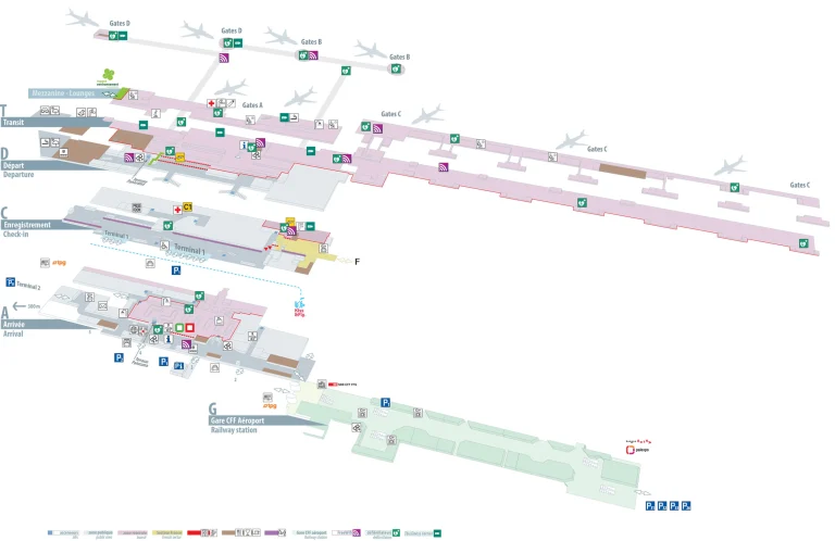
Nice-Côte d’Azur Airport Terminal 1 Map 2025
Nice-Côte d’Azur Airport Terminal 2 Map 2025
2026 Nice-Côte d’Azur Airport Map Guide
What is the exact walking route (and distance) from Terminal 2 Arrivals baggage claim to the Terminal 2 “dépose minute” pickup lane on the departures level?
Walking is about 120–150 meters total, but the level change is what adds time. From Terminal 2 baggage claim on Arrivals Level 0, exit into the public Arrivals Hall and do not go out through the first curbside doors.
From the Arrivals Hall, head to the central vertical transport bank between Exits A2 and A3, then take the escalator or elevator up to Departures Level 1. On Level 1, exit the building through Door D1 or Door D3 (D2 aligns more with Parking P5 access), then use the pedestrian crosswalk to reach the median lanes signed “Dépose Minute.” Allow 3–5 minutes extra for elevator waits and crowding at the lift bank.
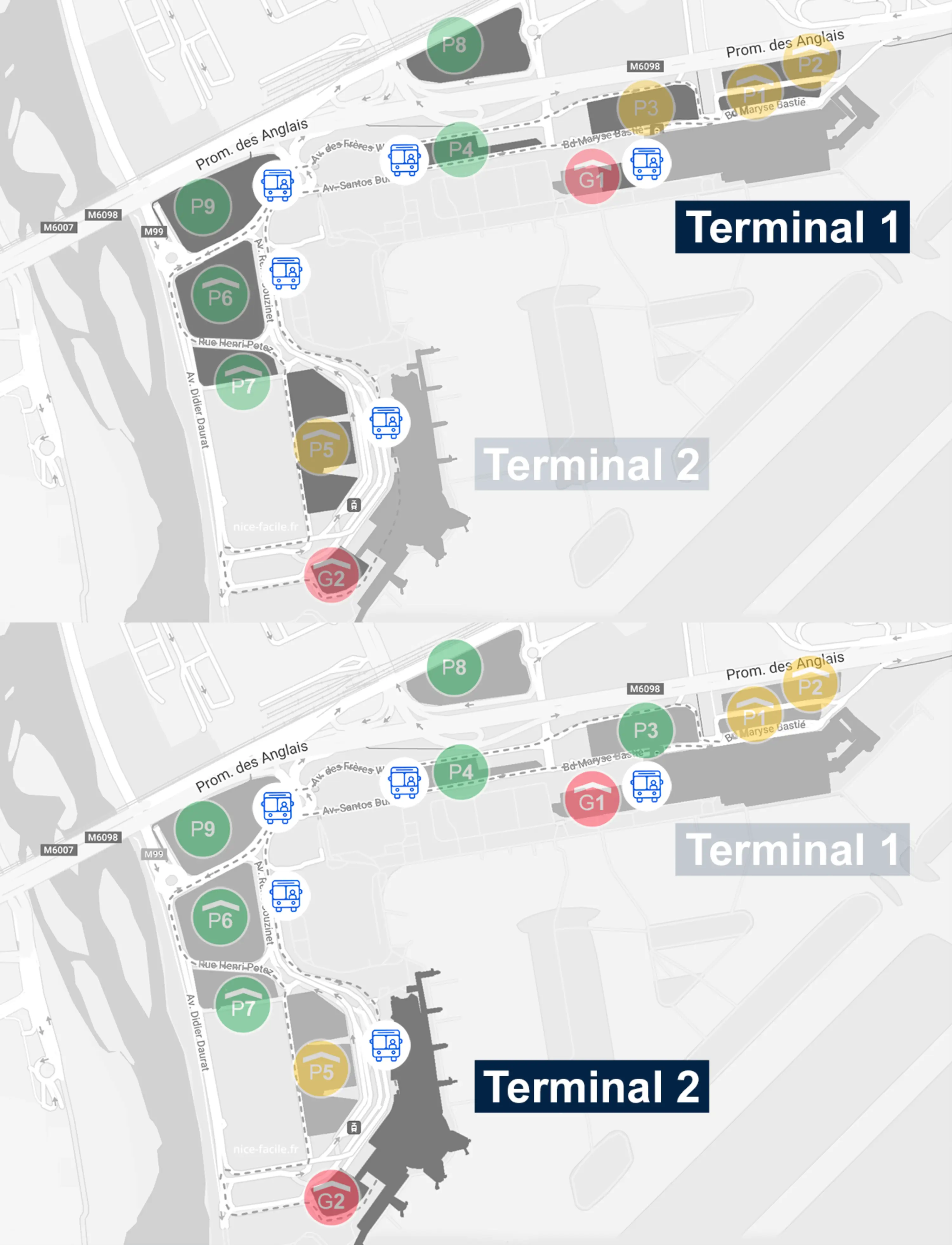
Where is the Terminal 2 “dépose minute” vehicle entrance (roadway approach) and what is the exact turnaround path if a driver misses the entry?
The “dépose minute” entrance is on Boulevard Jacqueline Auriol Supérieur, in the Terminal 2 approach split where traffic divides for Terminal 2, Parking P5, and the kiss-and-fly lanes. The entry is a narrow, gated lane adjacent to the Parking P5 access, so drivers who drift into the wrong lane usually can’t correct because of hard medians and barriers.
If the entry is missed, the fastest recovery is typically to continue into a parking approach (often Parking P5), circulate to the first available exit, and immediately re-approach the terminal lanes. If the terminal frontage is fully bypassed, follow “Sortie” signs out of the terminal precinct, merge onto the airport perimeter loop (via Boulevard René Cassin / internal loop roads), then re-enter the full Terminal 2 approach sequence; this loop is roughly 3–5 km and commonly adds 8–15 minutes depending on traffic.
Where is the Terminal 2 → Terminal 1 inter-terminal tram access point inside Terminal 2 (which doors/escalators/elevators lead to it)?
The tram access point is landside at ground level, directly outside Terminal 2’s Arrivals Hall frontage, and it lines up best with Exits A2 and A3. From inside Terminal 2, the fastest “inside-to-platform” route is to aim for the Arrivals Hall glass façade and use the A2/A3 exit doors rather than drifting toward bus bays or other curb exits.
From the Arrivals Hall, walk straight to Exit A2 (A3 works similarly), pass through the automatic doors, cross the sidewalk (about 15 meters), and the tram platform is directly ahead and parallel to the terminal façade. If you’re on Departures Level 1, take the central escalators/elevators down to Arrivals Level 0 first, then follow signs for “Tramway” or, if missing, “Gare Routière / Bus Station,” which runs in the same frontage corridor.
What is the exact walk time and distance from Terminal 2 Arrivals exit to the inter-terminal tram platform (fastest path)?
Walking takes under 2 minutes and is roughly 40–50 meters from the closest Arrivals exit to the platform edge. The fastest path starts at Terminal 2 Arrivals Hall at Exit A2 (A3 is similar).
| Start point | Fastest route | Distance | Time |
|---|---|---|---|
| Exit A2 (Arrivals) | out doors → cross sidewalk → platform edge straight ahead | ~40–50 m | < 2 min |
| Exit A3 (Arrivals) | out doors → short straight walk along frontage → platform edge | ~40–60 m | < 2 min |
In Terminal 2, where is the gateside security screening zone located relative to check-in, and what is the exact pre-security-to-security queue entrance path?
Security screening is on Departures Level 1 above the check-in hall, with the queue entrance controlled by automated boarding-pass e-gates at the head of the security bank. The key map move is that check-in and bag drop are on Level 0, but the security entrance is only reached by using the central escalators/elevators up to Level 1.
From check-in on Level 0, go to the central vertical core (main escalators/elevators) and ascend to Level 1, then follow the main circulation toward the central security bank until you reach the e-gates that start the queue. The priority “Nice Access” lane sits on the far left of the same security bank, while standard lanes feed straight through into the post-screening duty-free circulation that splits onward into Zone A (Schengen) and Zone B (Non-Schengen).
For Terminal 2, which gate cluster(s) share the same security-lane set, and where do overflow lines physically back up to when multiple flights stack?
Zone A (Schengen) and Zone B (Non-Schengen) share the same centralized security-lane set on Departures Level 1. After screening, passengers split toward the A-gates (A01–A20) versus the B-gates (B21–B30+), with Zone B adding a second chokepoint at passport control after security.
When multiple flights stack, overflow lines back up out of the security bank and into the Level 1 atrium’s main circulation space—especially the retail/corridor area immediately before and around the post-security duty-free circulation. In Zone B peaks, the combined effect of security plus downstream passport control can make the Level 1 spine feel “gateside” even though screening itself is centralized.
What is the exact stop boundary of the “free tram segment” between Terminal 1/Terminal 2 and Grand Arenas (which station names mark the free zone edges)?
The free tram segment runs only between Aéroport Terminal 2, Aéroport Terminal 1, and Grand Arénas. Grand Arénas is the hard edge: the moment you stay on the tram past Grand Arénas in either direction, you are in the paid fare zone and subject to ticket inspection.
| Free-zone edge | Station name | What happens beyond |
|---|---|---|
| West edge | Aéroport Terminal 2 | beyond requires fare depending on line direction |
| Middle stop | Aéroport Terminal 1 | still free within the three-stop segment |
| East edge | Grand Arénas | past this stop = fare zone + inspections |
At Grand Arenas, where are the ticket machines that sell standard fares, and what is the exact platform-to-machine walking distance (fastest route)?
Standard-fare ticket machines are on the Grand Arénas tram platforms by the main platform access, not at the airport stops. The fastest platform-to-machine walk is about 30–60 meters, depending on where you step off the tram.
| Step | Route cue | Distance |
|---|---|---|
| 1 | Exit the tram at Grand Arénas and face the modern glazed station building | — |
| 2 | Walk toward the main platform access/entrance area (the busy pinch point for stairs/elevators) | ~20–40 m |
| 3 | Use the ticket vending machines positioned at the platform access zone (same node as validators/boarding flow) | ~10–20 m |
Where are the ticket validation points (validators) for tram riders starting at Terminal 2 and transferring at Grand Arenas (exact physical locations)?
Validators are inside the tram cars at each set of double doors, so the safest “always-valid” move is to validate immediately after boarding near the door you entered. At Grand Arénas, validators are also placed on the platforms at the main access node where most passengers funnel between the platform and the station structure.
If you start at Terminal 2 and ride free to Grand Arénas, buy your standard fare at the Grand Arénas platform machines, then validate right away either on the platform validator by the access point or, more reliably, on the onboard validator just inside the next tram you board. Inspections commonly happen after Grand Arénas, so the first door-area validator you see on boarding is the one to use.
What is the exact walking route from the Terminal 2 tram stop to the Grand Arenas train station entrance (including which side of the road/level changes)?
Walking takes about 7–10 minutes because the transfer includes a grade change via the footbridge. From the Grand Arénas tram platform, head toward the modern glazed station structure and the pedestrian overpass that connects to the rail platforms.
| Segment | Route | Distance / time |
|---|---|---|
| Tram → station base | Walk off the platform toward the station building and footbridge access | ~50–80 m |
| Up to footbridge | Take elevators or stairs/escalators to the Passerelle level | time varies (lift waits) |
| Cross over tracks | Walk across the footbridge spanning the rail lines | ~1–2 min |
| Down to platforms | Use elevators or stairs to descend to the correct rail platform (Voie 1/2) | time varies (lift waits) |
In Terminal 2 airside, where is the nearest free drinking-water point (fountain/refill) relative to the main gate-security area (or confirm it does not exist and map the nearest alternative)?
A free drinking-water fountain is in the B-gate sector near Gate B26, and fountains are otherwise scarce in the main post-security/duty-free area. Relative to the central post-security circulation, the closest reliable refill point is reached by continuing airside past duty-free toward the Zone B gates, then targeting the Gate B26 area.
The fountain sits adjacent to the female restrooms near Gate B26, so the simplest triangulation is “Gate B26 + women’s toilets.” If you are routed to Zone A (Schengen) and cannot cross into the B sector because of flow partitions, the nearest alternative becomes commercial purchase post-security or refilling an empty bottle at a restroom sink if potable cold water is available.
From Terminal 2 check-in, what is the exact walking distance to the farthest gate in the affected gateside-security area (the “worst-case walk”)?
The worst-case walk is about 450–500 meters from the central security checkpoint to the farthest gates at the ends of the piers, and it commonly budgets as 10–12 minutes once congestion and the duty-free routing are included. From check-in, you also have the Level 0→Level 1 ascent before you even start that long pier walk.
From the check-in hall on Level 0, go to the central escalators/elevators up to Level 1, enter security via the e-gates, then follow the forced duty-free circulation into the main pier. The farthest endpoints are typically in the outer Zone B gate stretch (for example around B32) or the remote/bus-gate extremities, where the corridor narrows and pedestrian friction becomes the real time cost.
Where is the pedestrian path from P5 parking to Terminal 2 Arrivals (which doors/bridges/levels), and what is the exact walk time?
Walking takes under 2 minutes from Parking P5 to Terminal 2, but it arrives on Departures Level 1 at Door D2, not Arrivals. The key “gotcha” is that meeting someone at Arrivals requires a Level 1→Level 0 drop after you enter the terminal.
From Parking P5, take the pedestrian walkway that connects directly to the terminal façade and enter through Door D2 (Departures Level 1). For Arrivals, go inside to the central elevators/escalators and descend to Level 0 Arrivals Hall and baggage claim; for pickup return, reverse the route back up to Level 1 and out via D2 to the P5 walkway. The vertical “yo-yo” is what adds variability during arrival banks.
If inter-terminal tram signage is missing/unclear, what is the exact backup wayfinding route (alternate stairs/elevators/corridors) inside Terminal 2 to reach the tram access point?
The backup route is to force yourself to the Arrivals Hall glass façade on Level 0 and exit via A2/A3, because the tram platform runs directly parallel to that frontage. If you’re anywhere airside or on Departures Level 1, the recovery move is “get to Level 0 Arrivals first,” then walk to the brightest exterior frontage where buses and tram sit.
From Departures Level 1, take the central escalators/elevators down to Arrivals Level 0, then walk toward the main public hall and follow any “Bus Station / Gare Routière” cues (even if “Tramway” is absent). Continue to Exits A2 or A3, pass through the doors, and you should see the tram platform straight ahead across the sidewalk. If you accidentally exit at a bus-heavy door, stay landside, walk along the terminal façade toward the A2/A3 frontage, and the platform remains parallel to the building.