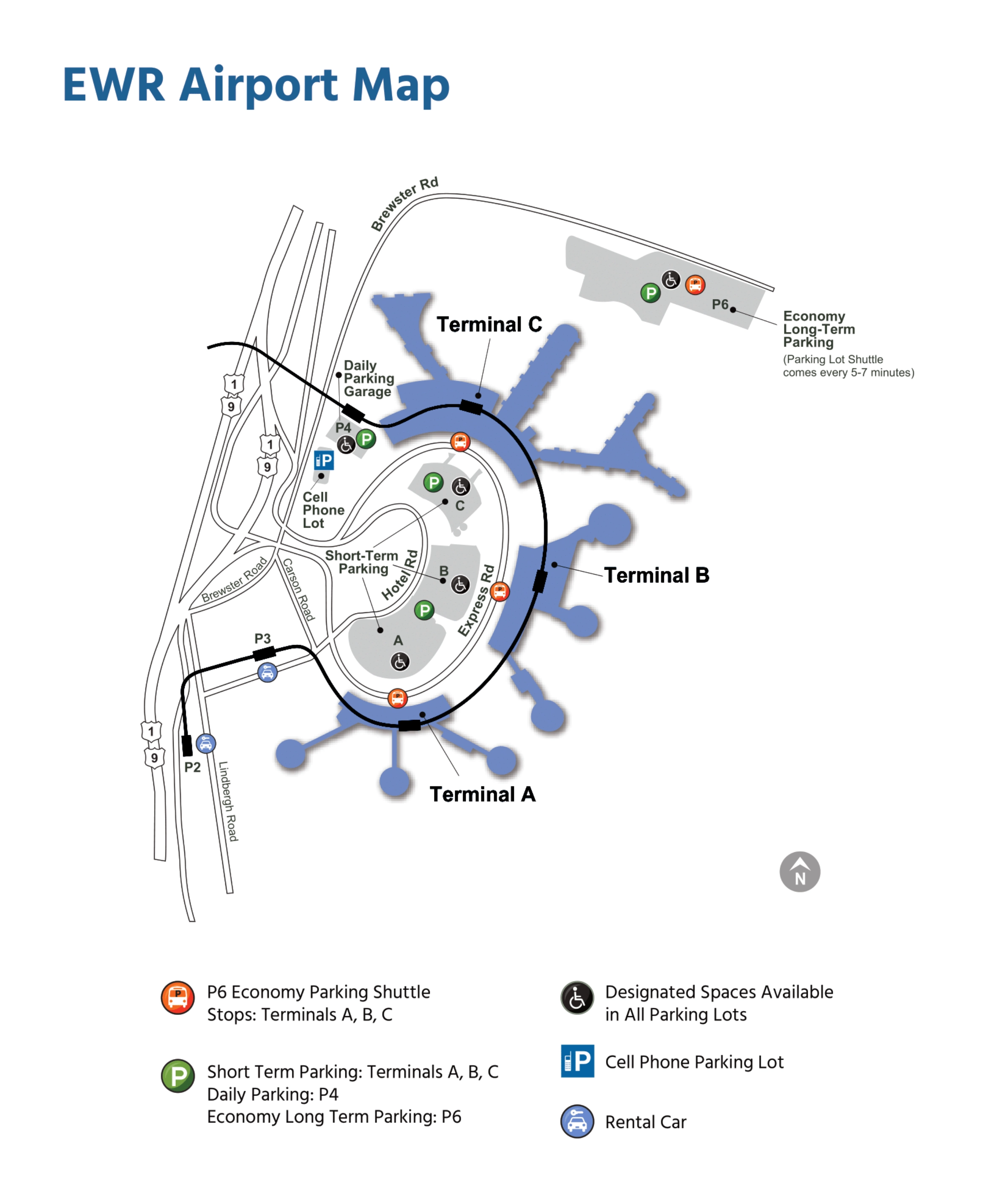
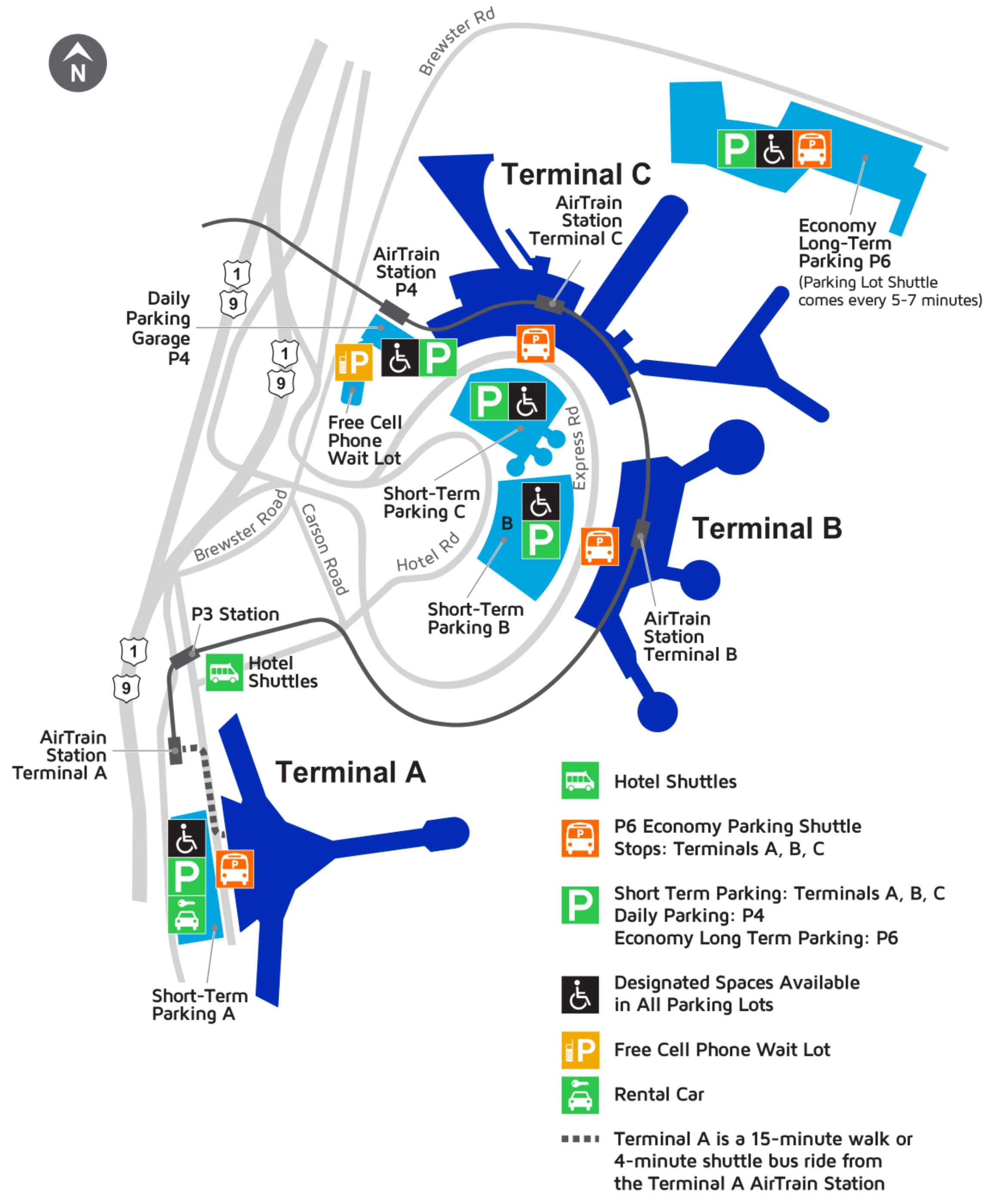
Newark Liberty International Airport Map (Most Up-To-Date)
Newark Liberty International Airport runs in a horseshoe-style terminal loop with three separated terminals (A, B, C) around the central roadway, with the AirTrain as the main landside connector. The footprint is wide and node-based rather than one unified hall: Terminal C anchors the south end, Terminal B sits mid-loop, and the new Terminal A is offset from the AirTrain station near the rental-car/garage complex—inside the Newark hub’s main terminal loop.
Map Table
| Terminal | Key Airlines | Primary Function | Transfer Mode |
|---|---|---|---|
| Terminal A | United (regional/domestic), partner carriers | New terminal processing, ConRAC adjacency | AirTrain + 0.2-mile gap, shuttle bridge/walk |
| Terminal B | Delta, JetBlue, Spirit, international carriers | Fragmented concourses, separate security “wings” | Landside only between wings, re-screen risk |
| Terminal C | United (main hub) | United hub gates, primary connections | Airside A↔C shuttle, AirTrain backup |
Newark Liberty International Airport Map Strategy
- Treat AirTrain as a “sometimes” link: memorize the bus-substitution nodes by terminal door/level, and plan a hard fallback route before you move.
- Budget Terminal A like a two-step transfer: AirTrain “Terminal A” stop is the garage/ConRAC node first, then the bridge walk or station shuttle to the real terminal entrance.
- Preserve secure status on United connections: use the post-security A↔C shuttle so you don’t get forced into landside transfers and a second TSA line.
- Navigate by anchors, not labels: pick exact doors/zones/gate-area landmarks for pickup, drop-off, and shuttle stops so construction signage doesn’t pull you into the wrong loop.
2025 Newark Liberty International Airport Map + Printable PDF
In 2026, Newark Liberty International Airport remains in a transition phase: Terminal A is modern and operational, while the legacy AirTrain backbone is the reliability weak point during maintenance and replacement-program disruptions. Expect shifting curb rules and staging areas, plus construction-driven pinch points that change how pickups, shuttles, and inter-terminal transfers actually work day-to-day.
2025 Newark Liberty International Airport Map Guide
What is the exact post-security shuttle pickup point in Terminal C for the A↔C airside bus (gate/landmark-level location)?
The Terminal C pickup point is the United airside shuttle portal at Gate C70/C71, reached from the secure concourse and then down an escalator to the ground-level bus loading area beside the C70 gate cluster.
Follow Terminal C signs toward the high-numbered C gates (the C70 area), then look for “United Shuttle” / “Terminal A Connection” wayfinding near the C70/C71 grouping. The boarding area is not a normal gate seat-and-jet-bridge setup: it’s a dedicated downstairs access point where you descend from the concourse level to the tarmac/bus bay, then board the non-stop shuttle to Terminal A.
What is the exact post-security shuttle drop-off point in Terminal A for the A↔C airside bus (gate/landmark-level location)?
The Terminal A drop-off point is the secure-side arrival portal at Gate A28, where you come up from the ground-level bus bay to the concourse near the A28 gate area.
After the shuttle ride from Terminal C, you exit at the dedicated bus facility and take the escalator up into Terminal A’s secure concourse at the A28 cluster. Use Gate A28 as the anchor for where you’ll reorient: it’s the consistent “you are here” waypoint for connecting onward inside Terminal A without exiting security.
What is the exact walking route from the Terminal A AirTrain station to the main Terminal A check-in/security entrance (which corridor/connector path)?
The most reliable walking route is the enclosed garage-to-terminal connector: go from the AirTrain “Terminal A” station into Parking Garage A/ConRAC, up to Level 2, then follow the signed pedestrian bridge straight into the Terminal A departures/check-in hall.
From the platform, follow signs that route you into the garage complex rather than down to the station bus curb. Use the Parking Garage A interior as your alignment cue, then take the elevator/escalator to Level 2 for the climate-controlled bridge. Stay on the bridge all the way until it delivers you into the terminal building at the departures/check-in level, which places you near the main security/checkpoint entry without needing the curbside shuttle.
What is the exact location of the Terminal A station shuttle/bus pickup used to bridge the AirTrain stop to the terminal entrance?
The Terminal A station shuttle pickup is the street-level curb directly outside the Terminal A AirTrain stop at the ConRAC/Parking Garage A complex, signed “Shuttle to Terminal A.”
From the AirTrain platform, go down to ground/street level (not into the pedestrian bridge route), then follow the “Shuttle to Terminal A” wayfinding to the dedicated curbside bus bay under/adjacent to the station/garage frontage. Use the ConRAC/Parking Garage A main exit doors as your anchor: the shuttle queue forms along that curb, and the bus runs a short loop to Terminal A’s upper (Departures) curb.
What is the exact curbside zone (level + door/section) for rideshare pickup at Terminal A?
Rideshare pickup at Terminal A is on the Arrivals level at Loading Zones 9 and 10, under the overhead curb markers for “Zone 9” and “Zone 10.”
Uber/Lyft geofencing at Terminal A effectively requires you to be standing in Zones 9–10 for the driver to start the trip. If you exit baggage claim near the early doors at the top of the hall (often Doors 1–2 area), keep walking laterally along the Arrivals curb until the large zone pylons/signs switch to “9” and “10.” Use the physical curb markers as the meet point, not “baggage claim” in the app, so you and the driver line up on the same side of the loop.
What is the exact roadway/ramp drivers must take to reach the Terminal A departures curb (alternate pickup workaround location)?
The best workaround pickup is the Terminal A Departures (Upper Level) curb, reached by taking the signed “Departures / Upper Level” ramp at the Terminal A roadway split before the Arrivals-level pickup lanes.
Drivers should stay on the Terminal A approach and follow overhead signs for Departures/Upper Level rather than Arrivals/Lower Level as the loop road divides. The ramp climbs to the check-in level curb directly outside the ticketing hall, which is usually less gridlocked than Arrivals during evening arrival banks. Use the check-in hall doors as the meet anchor: the passenger comes up one level from baggage claim (escalators/elevators) and exits to the departures curb, then matches the door number/section with the driver before the car enters the upper-level lane.
Where is the current hotel-shuttle staging stop at Parking P3 (exact stop position relative to the AirTrain/garage entrance)?
The hotel-shuttle staging stop is at AirTrain Station P3 on the ground-level curb immediately outside the P3 garage entry/exit, aligned with the marked “Hotel Shuttles” bays near the station-side entrance.
Use the AirTrain Station P3 exit as your anchor: once you leave the platform and reach the station/garage interface, stay on the station-facing curb (not deeper into the parking aisles) and look for the dedicated hotel-shuttle signage and lane markings. The practical rule is “P3 station curb by the garage/station entrance” rather than anywhere labeled “parking shuttle,” since P3 still serves multiple bus movements and only the clearly marked hotel bays match the off-airport shuttle lineup.
What is the exact walking path from the AirTrain stop used for hotel shuttles to the clearly-marked shuttle bays (which exit/side)?
The correct walk is to exit at AirTrain Station P3 to the station-facing curb and then follow the “Hotel Shuttles” signs to the marked bays along that same curb line.
After getting off at P3, take the main station exit down to street/curb level and orient toward the garage entrance you just came through rather than crossing into the parking structure. Stay on the exterior curb adjacent to the station/garage frontage and walk to the section with the dedicated hotel-shuttle lane markings and “Hotel Shuttles” placards. If you find yourself inside the garage lanes or standing at general parking-shuttle stops, you’re one zone off—backtrack to the station-side curb by the AirTrain/P3 entrance.
What is the exact rental-car shuttle pickup location at Terminal C (door/curb segment + signage landmark)?
No rental-car shuttle pickup exists at Terminal C for the on-airport rental cars because rentals are centralized at the Consolidated Rental Car Center by the “Terminal A” AirTrain station. The correct “pickup point” is the Terminal C AirTrain station entrance inside the terminal, following “AirTrain” signs rather than looking for a curbside rental bus.
From Terminal C landside, walk to the AirTrain station connection (the station is integrated with the terminal) and board AirTrain to “Terminal A” station. That stop is the ConRAC/Parking Garage A node for rental cars, where you follow “Rental Car Center / ConRAC” wayfinding into the garage levels for agency counters. Don’t wait curbside at Terminal C for a rental bus, and don’t divert to P2/P3 expecting older rental lots—go straight to the Terminal A station ConRAC complex.
What is the exact rental-car shuttle pickup location at Terminal A (door/curb segment + signage landmark)?
No rental-car shuttle pickup exists at Terminal A because the rental cars are in the connected Consolidated Rental Car Center within Parking Garage A at the AirTrain “Terminal A” station. The correct access point is the pedestrian bridge/indoor connection from Terminal A into Parking Garage A/ConRAC, not a curbside shuttle bay.
From Terminal A, follow “Rental Car Center / AirTrain” signs toward the connector that leads into the garage complex, then use the labeled ConRAC levels for agency counters (Parking Garage A/ConRAC is the landmark). If you’re standing at the Arrivals or Departures curb looking for a “Rental Car Shuttle,” you’re in the wrong mode—rental access here is building-to-building via the garage/ConRAC node rather than by bus.
In Terminal B, where are the separate security checkpoint entrances that split the terminal into distinct wings (map positions)?
Terminal B has three separate TSA entrances—one each for gate ranges B40–47, B51–58, and B60–68—so the checkpoint you choose determines which wing you can access.
| Terminal B wing | Gates served | Security entrance you must target | Anchor cue in the public hall |
|---|---|---|---|
| Concourse B1 | B40–B47 | TSA for Gates 40–49 | Wayfinding for “Gates 40–49” / B1 carriers (often first checkpoint travelers see) |
| Concourse B2 | B51–B58 | TSA for Gates 50–59 | Wayfinding for “Gates 50–59” / mid-terminal checkpoint area |
| Concourse B3 | B60–B68 | TSA for Gates 60–68 | Wayfinding for “Gates 60–68” / Star Alliance international wing signage |
In Terminal B, what is the exact landside route from one wing to another without accidentally re-entering the wrong checkpoint (corridor/connector alignment)?
The safe landside transfer is the pre-security public corridor behind the check-in areas that parallels the concourses, using gate-range signage to walk to the correct checkpoint entrance before re-screening.
Stay landside and follow overhead signs that name the target gate block (Gates 40–49, 50–59, or 60–68) rather than airline logos, because each wing’s TSA entrance is its own “commit point.” Use the check-in hall as your alignment: keep the ticketing counters on one side and the TSA entry portals on the other as you walk. Do not join the first security queue you see—walk past it until the signage matches your gate range, then enter that specific checkpoint so you don’t get trapped in the wrong wing and forced to exit/re-clear again.
What is the exact location of the landside inter-terminal shuttle stop at Terminal B (curbside bay position)?
The landside inter-terminal/AirTrain-replacement bus stop at Terminal B uses the Departures level curb at Door 6, which is the fixed anchor used during AirTrain outages.
Go to Terminal B’s upper/departures roadway level and find the curb segment signed for buses near Door 6. Use the door number as the meet point, not “Ground Transportation” generally, because multiple bus types share the frontage. If you are inside the terminal, follow signs to Departures/Upper Level, exit at Door 6, and look for “AirTrain Replacement” or “Emergency Shuttle” placards when the train is disrupted.
What is the exact location of the bus substitution pickup point used when the AirTrain is out of service (Terminal C side)?
The Terminal C bus-substitution pickup point is on the Departures level (Level 3) at Door 2, where “AirTrain Replacement” / emergency shuttle buses stage during outages.
Exit Terminal C to the upper departures curb and use Door 2 as your fixed anchor, then scan for the temporary outage signage posted on stanchions or placards near the bus lane. Don’t wait at the AirTrain station entrance when the system is down—these contingency buses load at specific curb doors instead. If you’re coming from inside Terminal C, follow “Departures” signage first, then target Door 2 to avoid ending up at the wrong curb segment among hotel, employee, and general shuttle traffic.
At Terminal C, where does the TSA queue physically begin when it spills out into the public hall (exact anchor point/landmark)?
The Terminal C TSA line typically starts at the roped stanchions in the public departures hall directly in front of the main security entrance, and when it overflows it extends back into the central check-in hall space aligned with the security-lane entry signs.
Use the security entrance itself as the fixed landmark, then look for where the first set of queue stanchions and TSA/queue signage is placed in the open hall. When the line grows, it usually projects outward from that entrance into the main circulation zone between the check-in counters and the central walkway, not down a side corridor. The practical navigation rule is to walk to the security entry portal first, then backtrack to the end of the stanchioned line—don’t join a crowd blob near the doors to the curb unless it is physically connected to the roped queue.
What is the exact shortest walking route from the Terminal C shuttle drop-off area to the nearest security checkpoint entrance (path geometry)?
The shortest route is Door 2 (Departures Level 3) straight into the departures hall, then forward to the main Terminal C security entrance in the central check-in hall.
From the shuttle/bus curb, enter Terminal C at Door 2 and stay on the same level—do not go down toward arrivals or toward the AirTrain connector first. Once inside, follow the overhead “Security / TSA” wayfinding through the open check-in hall, keeping the check-in counters to your sides as you move toward the center. The security portal is the large, roped entrance zone in the middle of the departures hall; the TSA queue stanchions are the final alignment cue that you’re at the checkpoint.
Archive Newark Liberty International Airport Map
Below are all historical map versions for Newark Liberty International Airport. Each year includes the official map available for that period, presented as both WebP and PDF.
2024-2022 Newark Liberty International Airport Map (Official 2022 Edition)
2021-2018 Newark Liberty International Airport Map (Official 2018 Edition)