Nashville International Airport Map (Most Up-To-Date)
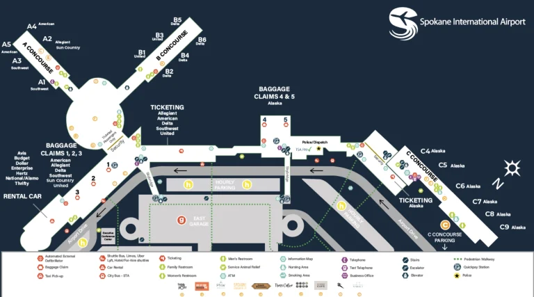
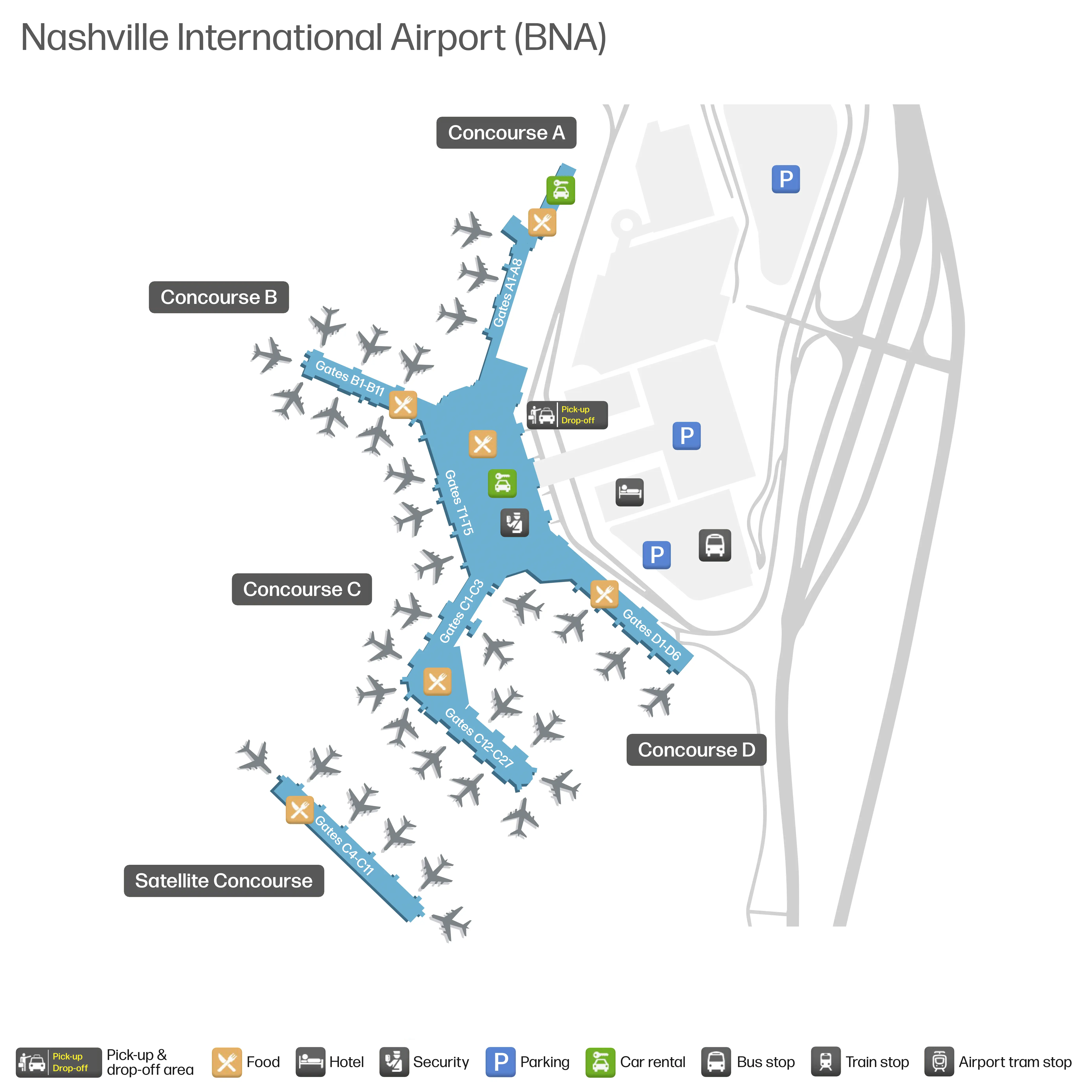
Nashville International Airport is a single-terminal complex with a central Grand Lobby and security checkpoint feeding concourse “spokes” (B north, C south with a satellite via shuttle, and D as the newer south-side pier). Landside access is dominated by a one-way Terminal Drive loop wrapping parking garages, with arrivals/departures stacked by level. Within Nashville’s primary airport complex, the biggest navigation stakes happen before you ever park: which I-40 exit you take, which loop lane you choose, and where rideshare/cell-lot staging actually lives today.
Map Table
| Terminal | Key Airlines | Primary Function | Transfer Mode |
|---|---|---|---|
| Grand Lobby / Central Security | All carriers | Check-in, TSA access, main wayfinding node | walk |
| Concourse B (north) | Delta, American, United | Gates, concessions | walk |
| Concourse C + Satellite C (C4–C11) | Southwest + mix | Gates; satellite gates via bus | shuttle bus |
| Concourse D (south, newer) | Southwest | Quieter gate area, wider corridors | walk |
| Ground Transportation Center (Garage 2) | Uber, Lyft | Rideshare pickup staging | covered walkway |
| Cell Phone Waiting Lot (off-site) | All pickups | Vehicle staging | drive |
Nashville International Airport Map Strategy
- Treat landside as the real map: commit early to the correct I-40 exit (cell lot requires exiting before the airport), then hold a disciplined lane position on the Terminal Drive loop to avoid the stoplight/rental-car splits.
- Use decision-point driving: identify the last fork where missing a sign forces a penalty loop, and follow a recovery plan that returns you to Arrivals via Donelson Pike instead of full recirculation.
- Run pickups like a timed operation: leave the cell lot when the plane lands (not when the passenger texts curbside), and pre-select an Arrivals door range so you’re not merging across lanes at the curb.
- Treat rideshare as a garage meet-up: aim for Garage 2, Level 1 zones (Uber B/C, Lyft A) and route passengers to the Ground Transportation exit path so door/level confusion doesn’t turn into a second loop.
2026 Nashville International Airport Map + Printable PDF
Active construction from the New Horizon program continues to shift “what’s where,” especially landside. The Cell Phone Waiting Lot remains off-site at 1415 Murfreesboro Pike, and rideshare pickup is consolidated into the Ground Transportation Center inside Garage 2 (Level 1). Gate access can also include a non-walkable segment for Satellite Concourse C (C4–C11) that requires a shuttle.
2026 Nashville International Airport Map Guide
What is the exact driving route (road names + turns) from I-40 airport exit to the current Cell Phone Waiting Lot entrance at BNA?
Using I-40 Exit 216 (the airport exit) won’t take you to the current BNA Cell Phone Waiting Lot; the correct access is I-40 East Exit 215A to Briley Parkway South before you reach the terminal loop. Missing Exit 215A typically forces a long recovery loop.
| Segment | Action | Anchor point |
|---|---|---|
| I-40 E approach | Take Exit 215A | Briley Parkway / TN-155 S (before Exit 216) |
| Briley Parkway S | Continue ~2.5 miles | Stay on TN-155 S |
| Briley Pkwy Exit 4 | Exit to Murfreesboro Pike | Signalized intersection at ramp end |
| Murfreesboro Pike | Turn left onto Murfreesboro Pike | Busy commercial corridor |
| Murfreesboro Pike | Drive ~0.7 miles | Watch for cell lot beacon signage |
| Knight Valley Dr | Turn right onto Knight Valley Drive | Digital “BNA Cell Lot” sign near the light |
| Cell Lot entrance | Immediate right into lot | 1415 Murfreesboro Pike area access |
What is the exact driving time and distance (miles + minutes) from the Cell Phone Waiting Lot to the Arrivals pickup curb in normal flow (no crash conditions)?
Driving typically takes about 3.0–3.5 miles and 12–18 minutes from the BNA Cell Phone Waiting Lot to the Arrivals pickup curb in normal flow. Signal cycles on Murfreesboro Pike and merge friction on Briley Parkway usually matter more than the highway segment.
| Metric | Typical value | Anchor point |
|---|---|---|
| Distance | ~3.0–3.5 miles | 1415 Murfreesboro Pike → Terminal Drive Arrivals |
| Time (light traffic) | ~8–10 minutes | Green lights + clean merges |
| Time (normal flow) | ~12–18 minutes | Typical Murfreesboro Pike signals |
| Time (peak but no crash) | ~18–25 minutes | Briley Parkway + I-40/Exit 216B backup |
What is the exact pickup meeting point (zone name + level + nearest door number) for rideshare passengers at BNA?
Rideshare pickup happens in the Ground Transportation Center inside Terminal Garage 2 on Level 1, with Lyft in Zone A and Uber in Zones B and C. Door-numbering doesn’t apply inside the garage; the practical landmark is the terminal’s Ground Transportation/Rideshare exit on Level 1, which funnels you onto the covered walkway into Garage 2.
Rideshare at BNA is a garage meet-up, not a curb pickup. From Baggage Claim (Level 2), go down to Level 1, follow signs for “Ground Transportation / Rideshare,” exit the terminal through the automatic doors, cross the covered walkway, then enter Garage 2 Level 1 and match your app to the pillar-marked zone (A for Lyft; B/C for Uber).
What is the exact walking distance (feet/meters) from the rideshare pickup point to the main terminal baggage claim doors?
Walking is about 400–600 feet (120–180 meters) from the rideshare pickup zones in Terminal Garage 2 (Level 1) to the main terminal baggage claim doors, typically 3–5 minutes with luggage. The distance swings based on which rideshare zone bay you start in and which baggage-claim door bank you’re targeting.
| Segment | Route | Typical distance |
|---|---|---|
| Garage 2 (Level 1) | Leave Uber Zones B/C or Lyft Zone A toward the signed pedestrian exit | ~100–250 ft (30–75 m) |
| Covered connector | Walk the covered bridge/walkway toward the terminal’s “Ground Transportation / Rideshare” doors | ~200–300 ft (60–90 m) |
| Terminal vertical | Use the nearest elevator/escalator up to Baggage Claim (Level 2), then continue to the exit-door bank | variable (vertical + short interior walk) |
Where is the closest legal “quick loop” turnaround (road segment / turning option) that returns a driver from a missed curb approach back to Arrivals without re-circling the entire airport?
No legal U-turn exists on Terminal Drive at Nashville International Airport, so the quickest “recovery loop” is exiting the curb area to Donelson Pike South and reversing direction at the first signalized intersection. This avoids a full airport recirculation and typically gets you back to the Arrivals entry in one short out-and-back.
| Step | Action | Anchor point |
|---|---|---|
| 1 | Leave the Arrivals curb and follow “Exit to Donelson Pike” | Keep-right exit movement away from the terminal curb |
| 2 | Continue onto Donelson Pike South | Exit ramp deposits onto Donelson Pike southbound |
| 3 | Use the first signalized intersection to turn back | First traffic light after the exit (near airport service/taxi staging area access) |
| 4 | Head Donelson Pike North and re-enter the terminal loop | Follow “Terminal / Arrivals” signs back onto Terminal Drive |
Where is the exact merge choke point (location on the loop road) where drop-off traffic funnels down (multi-lane → single-lane) while interacting with Arrivals flow?
The merge choke point is the “Donelson Merge” just past the terminal-building curve, where the Departures-level down-ramp drops into the same outbound Terminal Drive stream as Arrivals traffic. This is the highest-conflict spot on the loop because two flows combine and immediately start sorting for different exits.
Outbound from the curbs, it happens after you pass the terminal frontage and the roadway straightens away from the buildings. Departures traffic comes in from the left/center via a descending ramp, while Arrivals traffic is already moving in the right/center lanes with buses and curb-loading behavior. Within the next short stretch (about a quarter mile), drivers also begin weaving to split toward I-40 West versus Donelson Pike, which amplifies braking and lane compression.
What is the exact pedestrian path (doors + corridors) from Security exit to the furthest common gates (by concourse letter) at BNA?
Walking to the furthest common gates is longest to the far end of Concourse C (around gates C20–C25) and typically takes about 8–12 minutes from the security exit. The route stays on the post-security spine: pick the correct left/right split at the checkpoint exit, then commit to the concourse corridor until the last gate cluster.
From the Central Security Checkpoint exit in the Grand Lobby (Level 3), turn right/south for Concourse C/D or left/north for Concourse A/B. For the furthest common walk in Concourse C, stay on the main C-concourse corridor and continue straight past the bus-transfer area (near C13) without descending; the corridor runs to the end gate cluster (C20–C25). For the long north-side walk in Concourse B, turn left/north, pass the A/B rotunda area, then continue down the B pier to the end cluster (around B10–B15), using the central corridor as your constant landmark.
What is the exact walking time/distance from Security to the quietest/least crowded gate area (by concourse + gate range) that people use to escape congestion?
Walking takes about 5–8 minutes (about 1,200 feet / 365 meters) from the Security exit to the quietest common “escape” area: Concourse D, Gates D1–D6. Concourse D tends to feel calmer because it’s a newer, dead-end pier with fewer pass-through pedestrians.
| Segment | Route cue | Anchor point | Est. distance/time |
|---|---|---|---|
| Security exit | Turn right/south | Post-security split for C/D | ~100–200 ft, 1–2 min |
| Connector | Continue past the Concourse C entrance | C-Concourse entry landmark | ~500–700 ft, 2–3 min |
| Concourse D | Stay in the C/D connector into D | D concourse threshold | ~300–500 ft, 2–3 min |
| Gate range | Continue to D1–D6 area | End of D pier | variable within ~1 min |
What is the exact location of Economy Parking shuttle stops (stop names + curb position) relative to the Arrivals level doors?
Economy Parking shuttles load on the Arrivals level from the center-island curb (the median between the inner and outer roadways), typically aligned near Doors 6 through 10. Waiting on the sidewalk directly against the terminal building is a common mistake because the buses don’t load there.
Economy shuttle zones are marked with overhead “Shuttle” signage and are commonly associated with Economy Lot B and Economy Lot C service. The practical wayfinding landmark is the crosswalk from the terminal doors: exit near Doors 6–10, cross into the commercial-vehicle lane, and continue to the center island where the marked shuttle bay begins. If you exit near the far north doors (around baggage claim 1–3), expect a longer walk southward to reach the densest shuttle loading area near that Door 6–10 band.
What is the exact walk distance from Terminal Lot A (closest pedestrian access point) to the Arrivals doors?
Walking is about 800 feet (about 245 meters) from the closest Terminal Lot A pedestrian access point to the Arrivals doors, and about 1,200–1,500 feet (365–460 meters) from the far end of the lot. Most travelers take 5–8 minutes depending on luggage and crosswalk timing.
The typical path runs from the Lot A sidewalk toward the Garage 1 / rental car facility side, then across the entrance road at the marked pedestrian crossing into the terminal’s ground-transportation frontage. From there, follow the sidewalk into the Arrivals-level door bank. The most consistent landmark is the garage edge: once you reach the garage/terminal interface, you’re within a short, direct walk to the Arrivals doors, but the approach can be exposed to weather outside the garage drip line.
What is the exact baggage claim carousel zone layout (carousel numbers and their positions) so a traveler can visually confirm “different belt” outcomes without wandering?
Baggage claim at Nashville International Airport uses a rectangular hall with Carousels 1–4 on the north end and Carousels 5–10 on the south end. The fastest way to avoid “wrong belt” wandering is to use the digital monitors immediately after you come down the escalators, then orient yourself by which end of the hall you’re standing in.
Carousel positions follow a simple north–south split. As you face the claim hall from the roadway side, the left/north end holds Carousels 1, 2, 3, and 4, while the right/south end holds Carousels 5, 6, 7, 8, 9, and 10. Travelers coming down near the north escalator bank often land close to Carousels 2–3, while the south escalator bank lands closer to Carousels 7–8, so changing ends can mean walking the full length of the room.
What is the exact walking route from a typical arrival gate cluster to the baggage office (lost/delayed baggage desk) at BNA?
The lost/delayed baggage office is typically along the baggage claim hall’s rear wall (roadway side), in the alcoves between the exit doors and the carousels, often toward either end near Carousel 1 or Carousel 10. Walking is mostly “follow baggage claim signs,” then a short scan once you’re in the claim hall.
| Step | Action | Anchor point |
|---|---|---|
| 1 | Follow overhead “Baggage Claim” signs from your concourse toward the central connector | Main post-gate corridor |
| 2 | Continue into the terminal’s claim access path and descend to Level 2 | Escalator/elevator bank to Baggage Claim |
| 3 | Face the carousels, then turn toward the roadway-side wall | Exit doors side of the hall |
| 4 | Walk the rear wall between exit doors and carousel edges, scanning alcoves for your airline’s Baggage Service Office | Between door banks; often nearer Carousel 1 or Carousel 10 |
What is the exact doorway / entrance location where bus boarding creates crowding (the “two-door entrance” issue), and what is the alternate less-congested entry nearby?
Bus-boarding crowding concentrates at the Arrivals-level center-island crosswalks aligned near Doors 6–8, where pedestrian flow from the terminal hits a narrow island curb and funnels toward the bus front door. This is where the “two-door” problem shows up: the mid-bus door is available, but the crowd stacks at the first door it sees.
The less-congested alternate entry is to walk downstream along the center island toward the Door 10 side of the shuttle zone before the bus arrives. Buses often pull forward to the far end of the marked bay; positioning yourself closer to that Door 10 alignment makes it easier to access the rear/mid door and avoids the densest knot of people and luggage carts at the Doors 6–8 crosswalk.
What is the exact vehicle approach lane drivers should use to reach the Arrivals pickup curb while avoiding the “extra stoplight” routing trap mentioned by locals?
The best approach is staying in the center-right lanes as you enter from Donelson Pike so you feed directly onto the ramp to the Arrivals curb without peeling into the rental car/recirculation sub-loop that hits a signal. The “extra stoplight” trap is most associated with drifting into the far-left splits marked for rental car return or recirculation.
From I-40 eastbound, use Exit 216B (Arrivals/Donelson Pike), then as the entry roadway widens, avoid the far-left lane choices that peel toward CONRAC/rental car return and avoid early far-right turnoffs meant for economy parking. Hold lanes 2–3 from the right (a center-right position) through the approach, following Arrivals-level signage up onto the curbside ramp. The landmark that confirms you’re on the clean line is staying on the main Terminal Drive feed with no at-grade intersection control before the curb.
What is the exact location of the cell lot signage decision point (the last fork/intersection where missing a sign forces a long penalty loop)?
The last high-stakes decision point for the BNA Cell Phone Waiting Lot is I-40 East at Exit 215A to Briley Parkway South (TN-155 S), before the airport’s main Exit 216 split. Missing Exit 215A commits you into the airport approach where cell-lot access is no longer direct.
As you approach the airport from downtown on I-40 East, Exit 215A appears about a mile before the terminal exits and functions like a “point of no return.” If you stay on I-40 and pass it, you’ll be funneled to Exit 216A/216B for Terminal Drive instead. The recovery route typically requires entering the loop, exiting to Donelson Pike South, then driving back out toward Murfreesboro Pike to reach the 1415 Murfreesboro Pike cell lot—turning what should be a staging move into a significant time penalty.