Munich Airport Map (Most Up-To-Date)
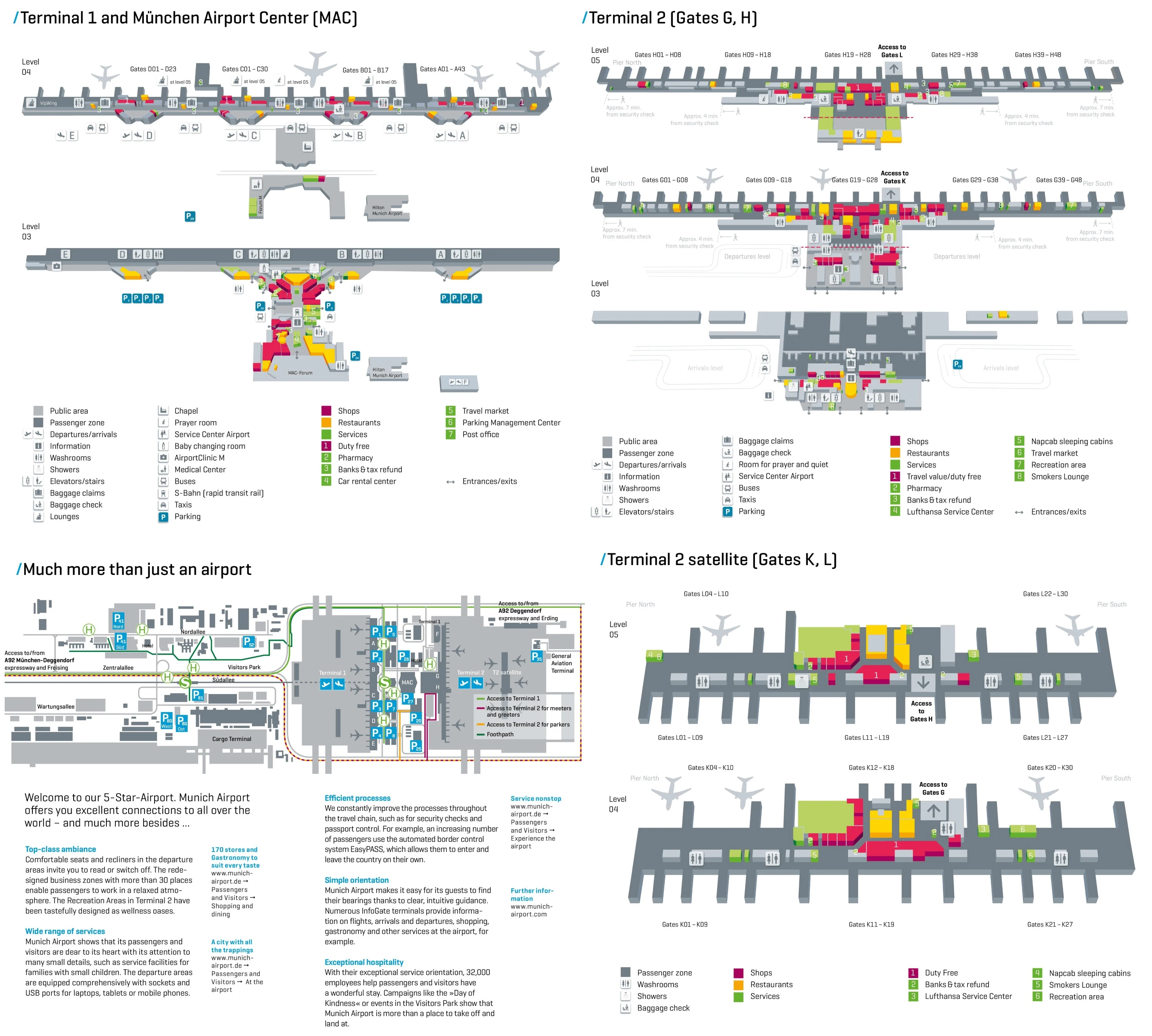
Munich Airport is arranged as two primary terminals split by the Munich Airport Center, with Terminal 1’s lettered modules stretched to the west and Terminal 2’s central hall and long piers extending east toward the Satellite. The overall footprint is wide and linear, with most long walks running north–south along piers or west–east across the MAC connector. Within Munich’s main airport complex, the biggest time hits come from level changes, passport control, and forced train/bus legs.
Map Table
| Terminal | Key Airlines | Primary Function | Transfer Mode |
|---|---|---|---|
| Terminal 1 (A–E) | Oneworld, SkyTeam, others | Modular check-in + gates | landside via MAC, airside transfer bus |
| Terminal 2 | Lufthansa, Star Alliance | Central hall + G/H piers | vertical level changes, corridor walks |
| T2 Satellite (J/K/L) | Lufthansa Group, Star Alliance | Overflow pier + remote stands | PTS train only |
| Bus Gates (Level 03) | mixed | apron stands | escalator/elevator down + bus ride |
Munich Airport Map Strategy
- Treat passport control and security as the true choke points, not the straight-line distance; Schengen↔non-schengen moves in Terminal 2 often bottleneck at the central Level 05 immigration filter above the main plaza.
- Budget for hidden legs you cannot walk away from: the Terminal 2 Satellite requires the PTS train, Terminal 1↔Terminal 2 airside transfers can force a shuttle bus, and “Gate 60–80” style bus gates mean a downstairs move plus an apron bus ride.
- Kill long walks by choosing the correct Terminal 1 module at entry; being at the wrong letter can turn a <75 m curb-to-security path into a 400 m+ landside correction before you even queue.
- Expect time loss from level changes (Terminal 2’s G/H stacking, bus gates on Level 03); if your route includes a down-up cycle, assume the escalator/elevator hunt is part of the connection time.
2026 Munich Airport Map + Printable PDF
The 2026 terminal layout still behaves like two different systems: Terminal 1’s lettered modules with separate “curb-to-security” entry points, and Terminal 2’s stacked Schengen/Non-Schengen levels with centralized passport control. The Satellite connection remains a mandatory underground PTS leg, and bus gates on Level 03 can quietly add a second “travel segment” after you think you’ve reached your gate.
2026 Munich Airport Map Guide
What is the exact walking distance (meters) from T2 Satellite arrival gates (K/L level) to the first passport control point for Schengen↔non-Schengen transfers?
The effective walking-and-transfer distance is approximately 750–800 meters to the first high-capacity passport control point used for Schengen↔non-Schengen transfers, because the route typically forces a return to the main Terminal 2 core via the underground PTS station.
| Segment | Adjacent landmark | Approx. distance |
|---|---|---|
| Satellite gate area (K/L) → Satellite core | central Satellite “spine” by the PTS access | ~300 m |
| Satellite core → PTS platform | escalators down to Level 02 | level change |
| PTS ride (Satellite → Terminal 2) | tunnel between stations | ~400 m |
| Terminal 2 station → passport control entry | escalators up toward the Level 05 transfer core above the main plaza | ~50–100 m |
Where is the exact location (named corridor/landmark) of the primary passport control chokepoint when transferring T2 Satellite (K/L) → T2 H gates?
The primary passport control chokepoint is the centralized immigration hall on Terminal 2 Level 05 that separates the Schengen-side atrium from the H-gates (non-Schengen) departures level. It sits directly above the main Terminal 2 plaza, where flows from the PTS escalators and the central retail/duty-free corridor converge under overhead “Gates H” signage.
What is the shortest signed walking route (by named landmarks) from Terminal 1 check-in area to the nearest security entrance, and what is the distance?
The shortest signed route is typically under 50–75 meters, because each Terminal 1 module places its security checkpoint directly behind the module’s check-in counters. Enter the correct module’s sliding doors from Departures Level 04 curbside, walk straight to the linear check-in hall, then continue past the rear of the counters to the central security lanes in that same module, marked by the tray/roller-bed entrance. If you enter the wrong lettered module, the “shortest” path breaks and becomes a 400-meter-plus landside correction along the Terminal 1 frontage.
Which specific Terminal 1 module/zone (A–E or equivalent) has the most direct post-security path to the main departure concourse (least backtracking), as shown on the terminal map?
Terminal 1 Module D has the most direct post-security path with the least backtracking, because it sits closest to the Munich Airport Center side of Terminal 1 and feeds into the adjacent airside corridor without the long landside frontage walks that hit Modules A or C. After clearing the Module D security lanes behind the check-in hall, the gate corridor connection is immediate, and the module’s position reduces the “wrong-module” penalty when approaching from the MAC/S-Bahn side.
Where is the exact shuttle bus stop for Terminal 1 ↔ Terminal 2 airside/transfer bus (name the closest door/gate marker), as shown on airport maps?
The airside/transfer bus stops are shown at specific gate markers: Terminal 1 uses Gates A28 and D08 for Schengen-side transfers and Gate C08 for non-Schengen-side transfers, while Terminal 2 is mapped with the Schengen-side stop near Gate G83 and the non-Schengen-side stop near Gate H15. These are the door/gate anchors to follow on the terminal maps when you’re routing between terminals without going landside.
What is the walking distance from Terminal 2 (main building) to the T2 Satellite shuttle train entrance, measured along the mapped passenger path?
The walking distance ranges from about 50 meters to about 550 meters, depending on where you start on the Terminal 2 pier. From the central Terminal 2 plaza area (around the pier root), the PTS descent node for the Satellite is essentially adjacent and can be reached in ~50 m. From pier-end gates (for example at the far ends of the north/south piers), you walk the full pier length back to the central atrium before turning toward the “Satellite” signs and escalators down to the Level 02 PTS station, which pushes the mapped path to roughly ~550 m.
What is the exact train-to-gate sequence (stations/levels) shown on maps for reaching T2 Satellite gates J/K/L from Terminal 2 security?
The mapped sequence is Terminal 2 security on Level 04 → descend to the PTS station on Level 02 → ride the PTS train to the Satellite station on Level 02 → ascend to the departure level that matches your gate group. After clearing central security on Level 04, follow overhead signs for “Satellite / Gates K, L” through the main plaza retail corridor to the Satellite escalator banks, go down to Level 02 for the PTS platform, take the train, then go up in the Satellite: K gates via Level 04 (Schengen) and L gates via Level 05 (non-Schengen), then continue along the Satellite pier to your specific gate number.
What is the shortest mapped path from the Munich Airport Center (MAC) underground corridor to Terminal 2 departures, and what is the distance?
The shortest mapped path is about 150–200 meters from the center of the Munich Airport Center underground corridor to Terminal 2 departures. From the MAC Level 03 corridor, walk east toward the Terminal 2 glass façade and the main Terminal 2 entrance, then take the first escalator/elevator bank up to Level 04 where the departures/check-in hall begins. The key triangulation point is the MAC Forum centerline: staying on the straight MAC-to-T2 axis avoids detours through Terminal 1 module frontage.
For a bus gate scenario, where is the bus boarding point located relative to the main gate numbering area on the terminal map?
The bus boarding point is downstairs on Level 03 under the pier root, not out on the main jet-bridge concourse where the primary gate numbers line the pier. In Terminal 2, it’s shown as the “Gates 60–80” or “Hates 60–80” zone stacked beneath the central pier junction.
Bus-gate access usually starts near the pier’s low-number gate area (around the G10/G30 or H10/H30 junction), where signs point to “Gates 60–80” beside escalator/elevator banks. After you go down to Level 03, the boarding doors line a basement-style corridor feeding the apron bus stands, and the bus ride becomes an extra leg before the aircraft.
What is the exact walking distance from Terminal 1 arrivals baggage claim to Terminal 2 Level 03 check-in/bag drop, using the mapped indoor pedestrian route?
The mapped indoor walk is roughly 450–900 meters, because Terminal 1 baggage claim locations vary by module and the route crosses the Munich Airport Center to reach Terminal 2. From the closest Terminal 1 area near Module D, the indoor path through the MAC Forum to Terminal 2 is about 450 meters. From the farthest Terminal 1 side near Module A, the same indoor MAC crossing pushes the total to roughly 900 meters.
| Start point in Terminal 1 | Adjacent landmark | Approx. distance to Terminal 2 |
|---|---|---|
| Near Module D baggage claim | MAC Forum crossing | ~450 m |
| Near Module A baggage claim | MAC Forum crossing | ~900 m |
Where is the dedicated pre-boarding security area for certain US-bound departures located in Terminal 1 (nearest gate/zone marker on the map)?
The dedicated pre-boarding security area is shown in Terminal 1 around the Module C gate area, fed by the Gate C08 corridor and often routed to a lower-level holding/security zone. After clearing the normal Module C flow, US-bound passengers are typically directed toward the C-gates cluster and funneled down to the secondary screening area before entering the sterile waiting pen, with Gate C08 serving as the closest reliable map anchor for where the extra checkpoint begins.
What is the distance from the T2 H-gates passport control (level-change point) to the nearest departure gates, based on the mapped corridor path?
The distance is approximately 50–100 meters from the exit of the Terminal 2 Level 05 passport control to the nearest H departure gates, because the checkpoint feeds directly into the pier root. After you clear the central immigration hall above the main plaza, you emerge at the start of the H-gates concourse near the first low-number gates at the pier root, while longer walks to pier-end gates can run roughly 500–600 meters down the same corridor.