Minneapolis–Saint Paul International Airport Terminal 2 Map (Most Up-To-Date)
MSP Terminal 2 (Humphrey) is a compact, linear terminal with a split-level layout: Level 1 handles curb, ticketing, and baggage claim, while Level 2 concentrates both TSA checkpoints and the single Concourse H spine. Most navigation hinges on choosing the correct north (Orange Ramp) vs south (Purple Ramp) vertical core. Located within the Twin Cities airport complex, Terminal 2 has no airside link to Terminal 1—every terminal transfer is landside.
Map Table
| Zone | Connection | Walk Time |
|---|---|---|
| Level 1 Ticketing Lobby | Doors 1–6 curb, Sun Country kiosks/counters | 1–3 min door-to-kiosk |
| North Core | Orange Ramp skyway, TSA Checkpoint 1 | 2–4 min from Door 1/2 |
| South Core | Purple Ramp skyway, TSA Checkpoint 2 | 2–4 min from Door 5/6 |
| Concourse H | Gates H1–H14 | 6–8 min to H14 |
Minneapolis–Saint Paul International Airport Terminal 2 Map Strategy
- Treat Sun Country as a two-step system: kiosks first, then the bag-drop stanchions that begin immediately behind/downstream of the kiosk bank (the line does not “start” at the counters).
- Pick your checkpoint by ramp anchor before you go upstairs: Orange Ramp skyway = Checkpoint 1; Purple Ramp skyway = Checkpoint 2, with lane mouths that can shift by PreCheck/Reserve configuration.
- When lines look chaotic, walk into the correct skyway to find the real queue tail; spillover commonly starts inside the bridge or at the ramp-side elevator lobby, not at the podium.
- Assume Terminal 1 ↔ Terminal 2 is structurally impossible airside; use light rail landside and re-clear security every time.
2025 Minneapolis–Saint Paul International Airport Terminal 2 Map + Printable PDF
2026 Terminal 2 navigation still revolves around two variable choke points: Sun Country bag drop on Level 1 and TSA screening on Level 2. The newest “time saver” for carry-on travelers remains the Purple Ramp Level 2 skyway approach, which feeds directly into the south checkpoint frontage. Plan your print map around door numbers (Level 1) and ramp-skyway anchors (Level 2).
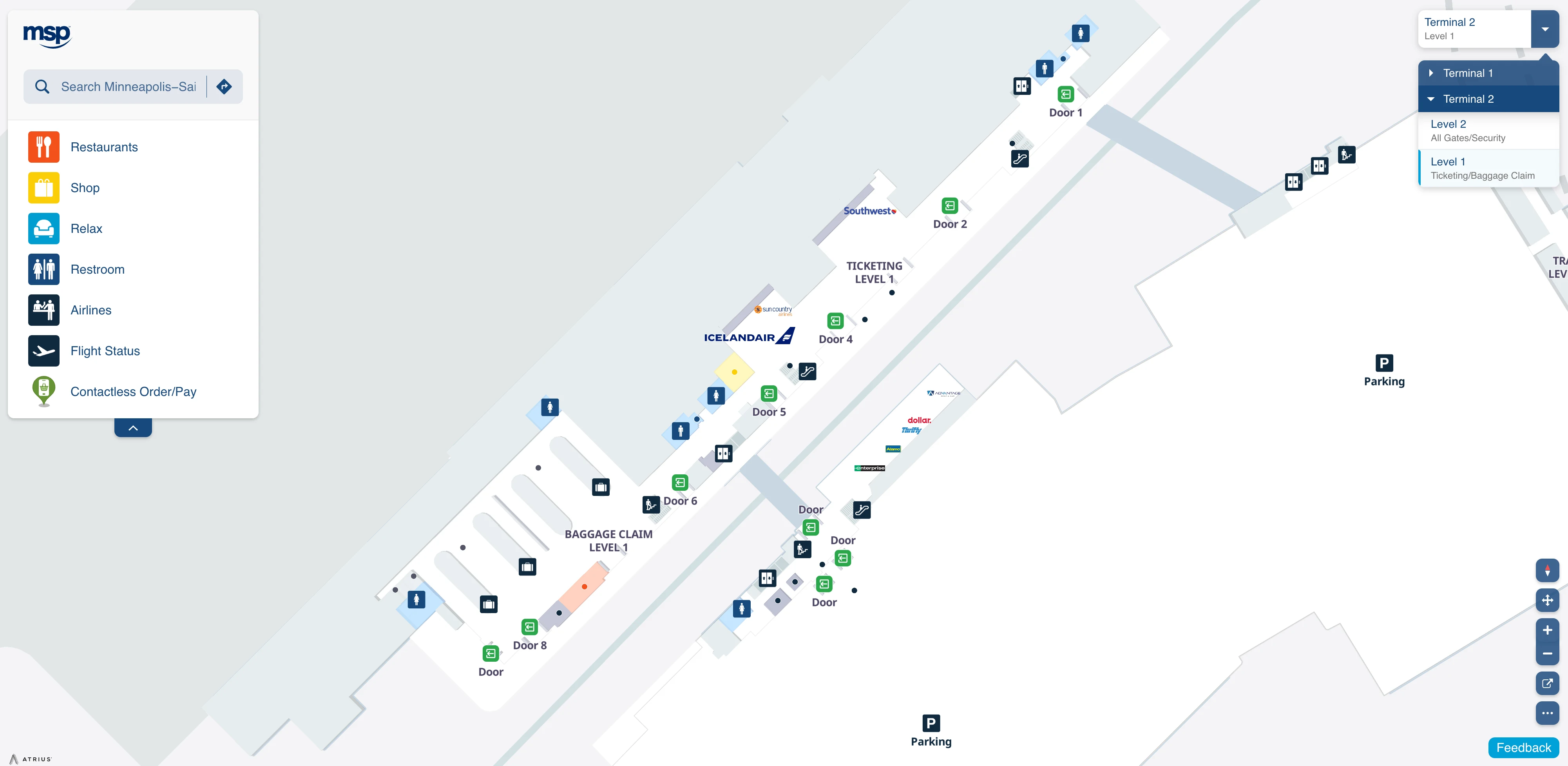
Minneapolis–Saint Paul International Airport Terminal 2 Level 1 Ticketing and Baggage Claim Map 2015
Minneapolis–Saint Paul International Airport Terminal 2 Level 2 Departures Map 2025
Minneapolis–Saint Paul International Airport Terminal 2 Level 2 Security Map 2025
2026 Minneapolis–Saint Paul International Airport Terminal 2 Map Guide
What is the exact physical start-point of the Sun Country checked-bag line in Terminal 2 relative to the self-tag kiosks (the spot where the queue “actually begins”)?
The Sun Country checked-bag queue begins at the stanchion maze entrance positioned immediately behind and “downstream” of the self-tag kiosk bank, not at the counters. After tagging your bag at a kiosk, pivot away from the screens and look for the opening between the kiosk cluster and the counters where the Tensabarrier lanes start.
That entrance is typically marked for “Bag Drop” or “Tagged Bags,” and it sits on the counters-side of the kiosks (so you must finish at the kiosk first to even see the real line). If you’re entering from Doors 2–3, expect the kiosks to act like a physical barrier—route around kiosk users to the stanchion opening rather than drifting toward the counter face.
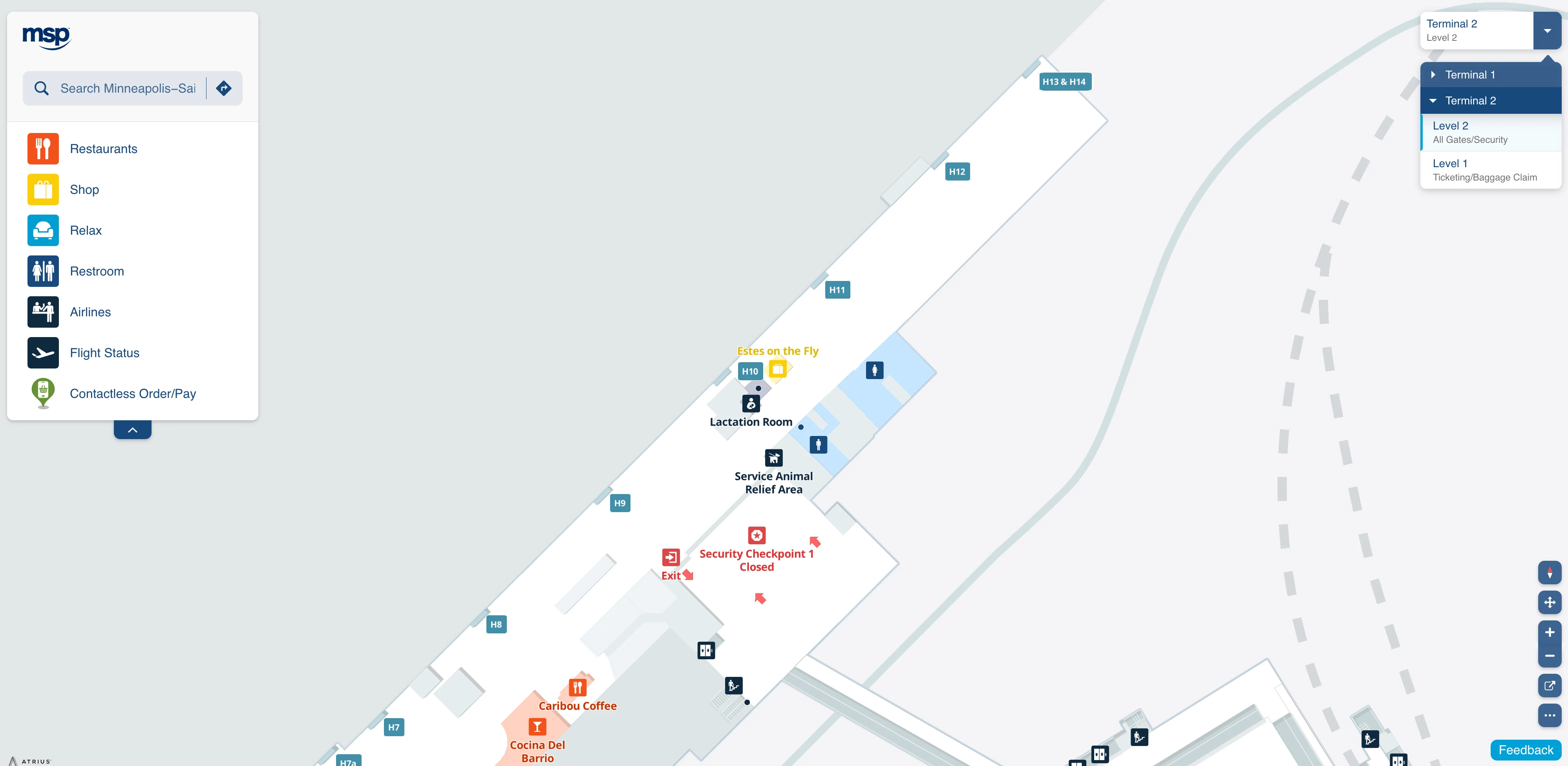
Which exact entrance point leads directly to TSA Checkpoint 1 near the Orange Parking Ramp Skyway (so a driver can drop you at the closest door)?
Door 1 is the closest curbside entrance for TSA Checkpoint 1 because it feeds the north escalators that land beside the Orange Parking Ramp skyway. Door 2 is the next-best backup if Door 1 is congested.
From the curb at Door 1 (or Door 2), enter the ticketing lobby and immediately target the north escalator bank anchored by “Orange Ramp” and “Light Rail/Trains” wayfinding. Ride up to Level 2; at the escalator top, TSA Checkpoint 1 is directly ahead/right, with the Orange Ramp skyway entrance adjacent. If you arrive upstairs and only see the skyway bridge and a line stretching into it, follow that bridge to find the true queue tail for Checkpoint 1.
What is the exact landside route inside the airport from Terminal 2 to Terminal 1 using light rail (including the station access points you must follow)?
No airside Terminal 2 ↔ Terminal 1 connection exists, so the transfer requires leaving the sterile area, taking light rail, and re-clearing security at the other terminal. The light rail station for Terminal 2 is accessed via the Orange Parking Ramp, not from the curb.
From Terminal 2 Level 1 (ticketing/baggage claim), go to Doors 1–2 and take the north escalators or elevator up to Level 2. Follow signs for Trains/Light Rail into the Orange Parking Ramp skyway, then descend inside the ramp to the Terminal 2 light rail platform. Board the Blue Line northbound one stop to “Terminal 1–Lindbergh,” then follow the Terminal 1 station exit up into the Terminal 1 landside concourse and proceed to its TSA checkpoint to re-enter airside.
Where is the exact rideshare pickup location at Terminal 2 relative to baggage claim (which door/curb zone is used for app pickups)?
Rideshare pickup is at the Ground Transport Center on the ground level of the Purple Parking Ramp, not at the Terminal 2 curb outside baggage claim. The closest exits from baggage claim are Doors 6 or 8, which put you on the correct side of the building to cross toward the Purple Ramp.
From Level 1 baggage claim, walk to Door 6 (primary) or Door 8 (farther south), exit to the sidewalk, and use the marked crosswalk across Humphrey Drive into the Purple Parking Ramp. Once inside the ramp, stay on the ground/street level and follow “App-Based Ride Services” signs to the pickup curb zone where Uber/Lyft stage. If your driver icon looks “stuck” across the street, that’s normal—they’re required to wait in the ramp pickup area.
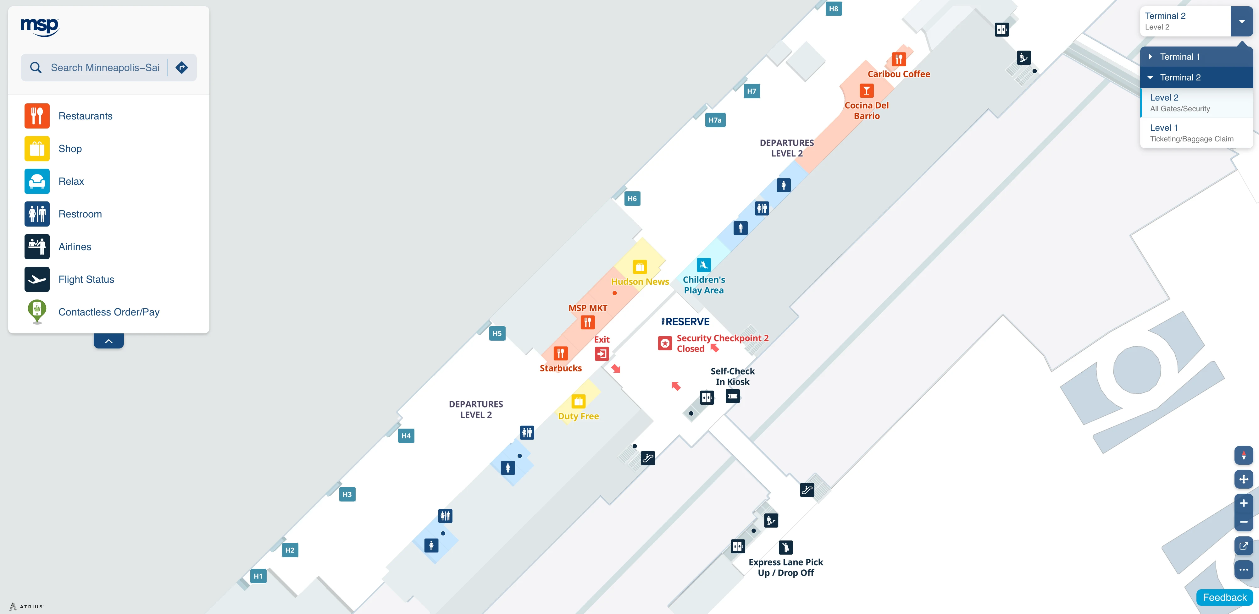
Where is the exact TSA PreCheck-only entry point at Terminal 2 when Checkpoint 2 is designated PreCheck (the lane mouth you should physically walk to)?
The TSA PreCheck-only entry point is the dedicated PreCheck lane mouth at TSA Checkpoint 2 on Level 2, directly beside the Purple Parking Ramp skyway doors. If Checkpoint 2 is operating as the PreCheck checkpoint, you should walk to the south checkpoint frontage (Purple side) and enter at the podium/signage labeled “TSA PreCheck,” not the general ID podium for standard screening.
Approach from Doors 5–6 on Level 1 and take the south escalators up, or come in from the Purple Ramp skyway and step into the terminal—Checkpoint 2 is immediately in front of you (roughly a few steps from the skyway threshold). In heavy periods when the line backs up, follow the PreCheck queue into the Purple skyway to find the true tail rather than stopping at the crowded checkpoint entrance area.
What is the shortest indoor route from the Purple Ramp Skyway connection to the TSA checkpoint entrances (so you don’t enter the wrong queue area)?
The shortest indoor route is the Purple Parking Ramp Level 2 skyway straight into the south checkpoint frontage at TSA Checkpoint 2. The walking distance from the skyway threshold to the checkpoint lane mouths is under a minute and is essentially “door-to-queue.”
Exit the Purple Ramp skyway into Terminal 2 Level 2 and stop at the first open area facing the checkpoint podiums; the lane mouths are immediately in front of you, with overhead signs for TSA PreCheck, MSP Reserve, and Priority. If you drift past the checkpoint frontage toward the central mezzanine, you’ll end up near the wrong crowd and may mistake Checkpoint 1 overflow for your line. Standard (non-PreCheck/Reserve) passengers should not join any Checkpoint 2 lane and must walk north to Checkpoint 1 by the Orange Ramp skyway.
After clearing security at Terminal 2, what is the closest restroom location to the checkpoint exit (first-restroom distance from exit)?
The closest restroom after TSA at Terminal 2 is the restroom block opposite Gate H5. From the checkpoint exit, you’ll recompose in the central post-screening area and then walk down the Concourse H spine to the H5 vicinity for the first reliably adjacent restroom.
Expect a short but non-zero walk: continue past the initial concessions/atrium zone and use Gate H5 signage as your anchor point; the restrooms are on the opposite side of the corridor across from that gate. A second major restroom block sits farther down the concourse between Gates H10 and H11, useful if you’re continuing toward the south end gates (H10–H14).
Where is the MSP Reserve (scheduled security) lane entrance located relative to the standard TSA line at Terminal 2 (the exact merge/entry point)?
The MSP Reserve lane entrance is at TSA Checkpoint 2 on Level 2, separate from the standard TSA queue that feeds TSA Checkpoint 1. You reach it on the south side of Level 2, anchored by the Purple Parking Ramp skyway, where Reserve signage directs you to a dedicated podium for appointment QR scanning.
At the Checkpoint 2 frontage, look for the lane marked “MSP Reserve” alongside (but distinct from) the “TSA PreCheck” and “Priority” lanes. The Reserve entry is not a mid-line merge into the standard Checkpoint 1 switchbacks; it is its own start point at Checkpoint 2, and any later merging happens only after ID verification when TSA funnels screened passengers into available screening positions within that checkpoint.
When the security line backs into the parking-ramp/skyway area, what is the correct path to reach the actual queue tail without accidentally joining the wrong line?
The correct path is to walk into the skyway that matches your checkpoint until you physically find the end of the stanchions or the last person in line. At Terminal 2, the true queue tail often lives inside the bridge or at the ramp-side elevator lobby, not at the checkpoint podium where the crowd gathers.
Use the ramp anchor to avoid joining the wrong mass: Checkpoint 1 overflow backs into the Orange Parking Ramp skyway on the north end of Level 2, while Checkpoint 2 overflow backs into the Purple Parking Ramp skyway on the south end. If you come upstairs and see a dense cluster near the mezzanine, do not “attach” there—move toward the appropriate skyway entrance and keep walking away from the terminal until you hit the unmistakable end of the line.
Where is the Sun Country “expedite” assistance point (the place they pull “flight closing soon” passengers from), relative to the main bag-drop counters?
The functional Sun Country expedite point is the Assisted Check-In / Full Service counter segment at the end of the main Sun Country counter line. When passengers are “flight closing soon,” triage typically happens there rather than through a permanently signed late-passenger chute.
In busy morning banks, the other practical expedite interface is the roaming Sun Country floor-agent presence near the self-tag kiosk bank in front of the counters. If you need help fast, intercept an agent in the kiosk zone first; they can direct you to Assisted Check-In or escort you forward. Relative to the bag-drop stanchions, this expedite/triage behavior is oriented toward the counter end-cap and the kiosk area, not inside the standard tagged-bag queue itself.
What is the walking distance from the TSA checkpoint exit to the farthest gate in Terminal 2 (longest-case walk inside the secure area)?
The longest walk is about 500 meters (1,640 feet, roughly 0.31 miles) from the TSA exit area to Gate H14. At a normal pace with luggage, that’s typically a 6–8 minute walk with no tram assistance.
Concourse H is a single linear spine, so once you’re past the checkpoint recomposure area, you just keep moving down the pier as gate numbers increase. Use the Gate H5 restroom block as a mid-concourse landmark; beyond that, the H10–H14 cluster is the distal end where Sun Country and Southwest frequently operate. Terminal 2 has no internal tram or long moving walkway system, so the far-gate case is fully on foot.
From baggage claim at Terminal 2, what is the shortest indoor route to the parking-ramp skyway entrances (so pickups in the ramp don’t require guessing)?
The shortest indoor route is to go up to Level 2 inside Terminal 2 first, then cross the correct ramp skyway from the mezzanine rather than exiting to the street. From Level 1 baggage claim, use the internal escalators/elevators to reach Level 2 and then choose Orange (north) or Purple (south) by the skyway signs.
From baggage claim, stay inside and head toward the Door 1–2 end for the north vertical core if you need the Orange Ramp skyway, or toward Doors 5–6 for the south vertical core if you need the Purple Ramp skyway. Once on Level 2, turn right/north for Orange Ramp or left/south for Purple Ramp and cross the enclosed bridge into the ramp structure. This keeps you indoors, avoids the roadway crosswalk, and lands you on the level where the skyways actually connect.
Archive Minneapolis–Saint Paul International Airport Terminal 2 Map
Below are all historical map versions for Minneapolis–Saint Paul International Airport. Each year includes the official map available for that period, presented as both WebP and PDF.
2018 Minneapolis–Saint Paul International Airport Terminal 2 Map