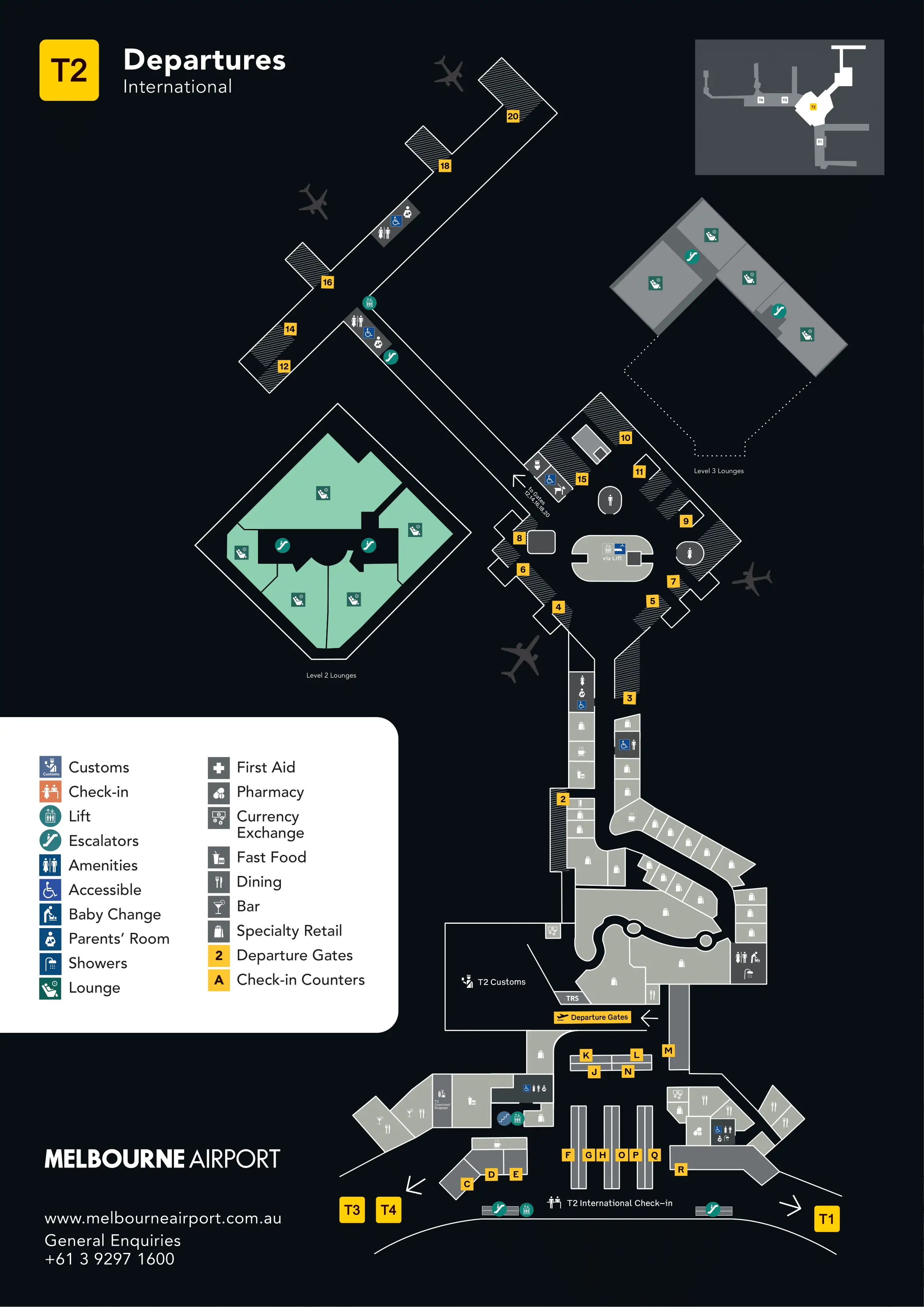
Melbourne Airport Terminal 2 Map (Most Up-To-Date)
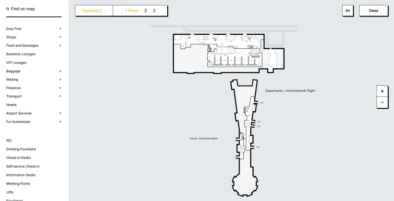
Melbourne Airport Terminal 2 (International) is a compact, linear terminal with most passenger movement running along the frontage side and then compressing into a few hard “valves” inside: immigration processing, biosecurity/customs, and the arrivals exit doors. Within Melbourne’s main airport grounds, Terminal 2’s footprint is small, but the process sequence is dense—so a single queue spike can cascade into baggage reclaim and the pickup forecourt.
Map Table
| Zone | Connection | Walk Time |
|---|---|---|
| Departures curb (Level 1) | Check-in hall entry | 1–3 min |
| Immigration hall | First kiosk bank → larger inner bank | 20–40 m |
| Security exit (airside hub) | Gate 10 pier | ~400 m |
| Arrivals hall doors | Pickup / rideshare forecourt | 2–6 min |
Melbourne Airport Terminal 2 Map Strategy
- Walk past the first ePassport kiosks and keep moving deeper to the larger inner bank before committing to a queue.
- Keep your declaration decision clean: paperwork ready before you enter the biosecurity funnel, because backtracking from the marshaled lanes is difficult.
- After customs, ignore the instinct to take the nearest door—use the most central arrivals doors near the main information landmark to reduce wrong-exit penalties.
- For rideshare, trust today’s temporary forecourt signage and the app pickup pin over older static maps; lanes and zones can shift with construction.
2026 Melbourne Airport Terminal 2 Map + Printable PDF
Current Terminal 2 wayfinding is still shaped by stacked processing choke points (eGates → Border Force/Biosecurity → baggage → exit) plus forecourt changes tied to ongoing roadworks. For 2026, treat curbside pickup and rideshare as variable-day layouts, and expect immigration queues to form at the first visible kiosk bank even when additional machines sit deeper inside.
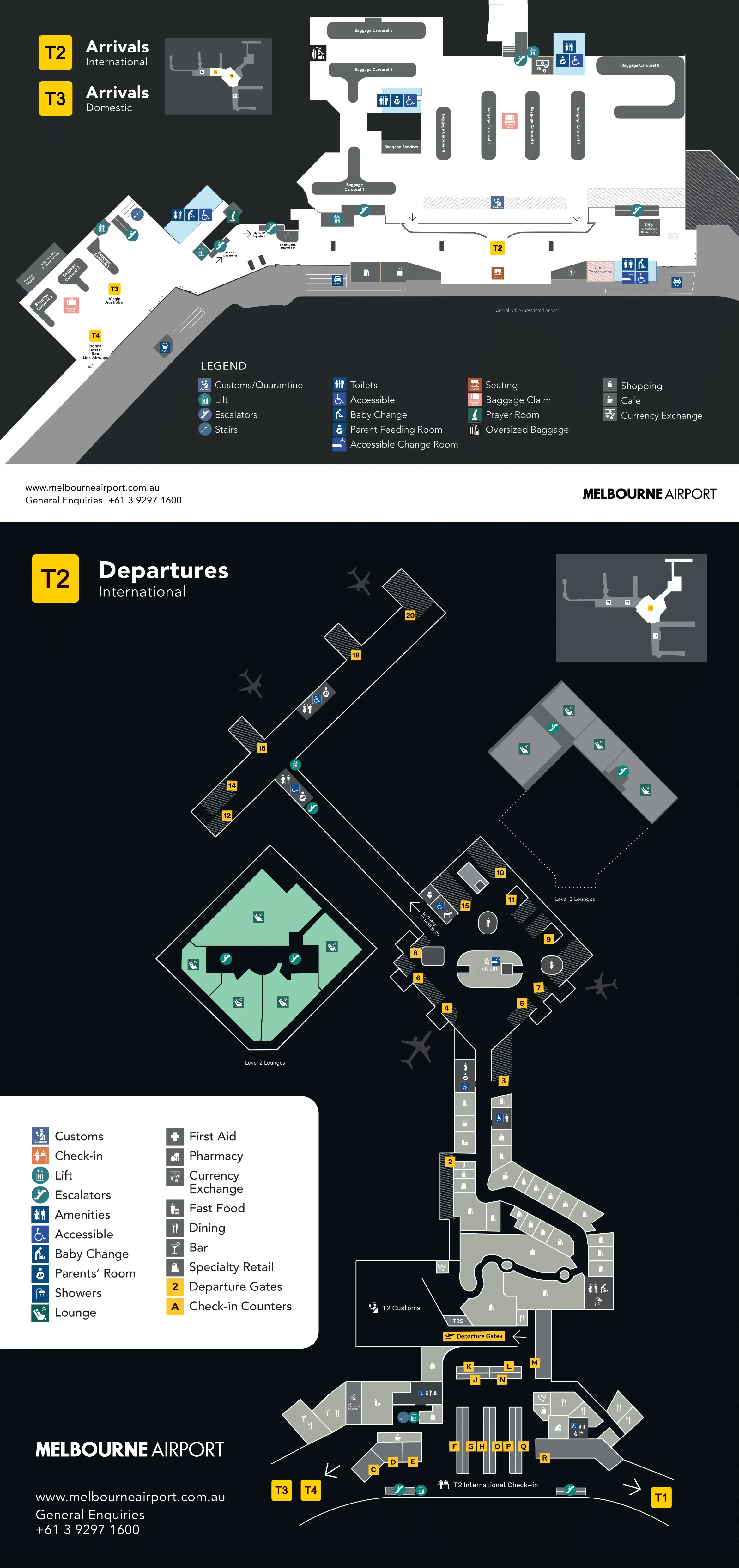
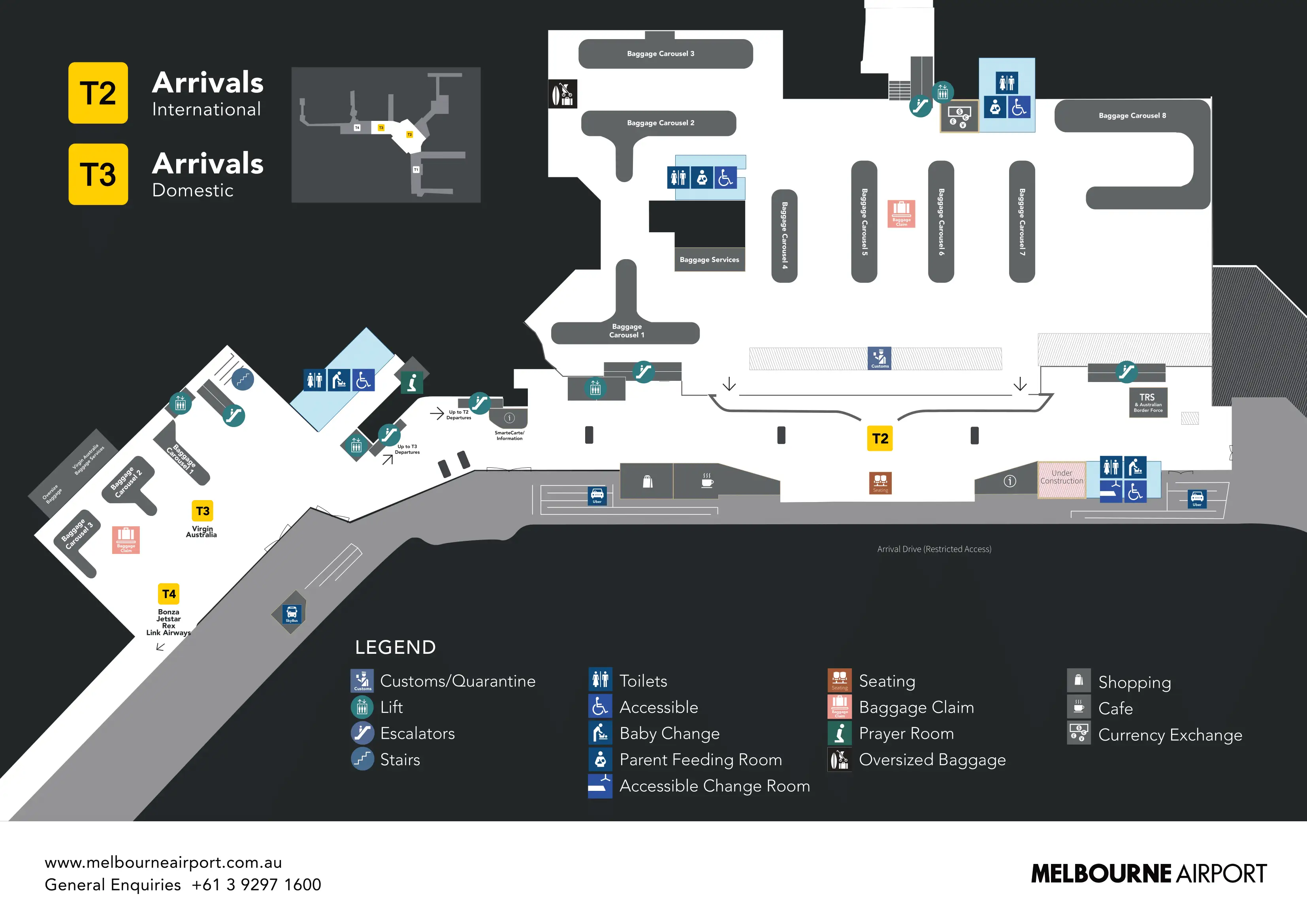
Melbourne Airport Terminal 2 and 3 International Arrivals Ground Floor Map 2025
Melbourne Airport Terminal 2 International Departures First Floor Map 2025
2026 Melbourne Airport Terminal 2 Map Guide
What is the exact physical location of the first eGate/kiosk bank that most passengers reach immediately after the arrivals corridor opens into processing?
The first ePassport kiosk bank sits immediately inside the immigration processing hall at the moment the arrivals corridor opens out, forming the first visible “cluster” straight ahead where passengers naturally stop and queue. This bank is the closest set of machines to the corridor mouth, so its line commonly spills back into the walkway during peak arrival banks.
The kiosk cluster is positioned at the front edge of the immigration hall, before the deeper “decompression” space that leads to the larger inner kiosk bank. Use the corridor opening itself as the anchor: if you can still see passengers emerging from the corridor behind you, you’re at (or just past) the first kiosk bank; continue forward into the hall to reach the larger set further in.
What is the walking distance (meters) from that first eGate/kiosk bank to the next larger bank of machines further inside immigration processing?
Walking distance is about 20–30 meters from the first ePassport kiosk cluster at the immigration hall entry to the larger inner bank deeper inside processing. That short “decompression” stretch is long enough to clear the entry-shock queue but short enough that most passengers don’t realize there’s a bigger bank ahead.
From the corridor mouth, pass the first kiosk bank where lines typically spill back into the arrivals walkway, then continue straight into the open floor of the immigration hall. The larger kiosk bank begins roughly one to two bus-lengths ahead, after the crowd density drops and sightlines open up across more machines.
Where is the biosecurity secondary queue physically located relative to the primary Border Force/immigration exit path for passengers who declared items?
The biosecurity secondary queue sits immediately downstream of the baggage reclaim carousels at the single exit funnel out of the hall, branching to the side of the primary walk-out path after the initial officer/marshal check. This means “declare” passengers are diverted into a side screening area rather than continuing straight toward the public arrivals doors.
After you collect bags, the flow pushes everyone toward the same marshaled lanes leading to the Border Force/Biosecurity decision point. An officer checks your Incoming Passenger Card and directs you either through the main exit corridor or into secondary screening. The secondary queue forms alongside the main exit vector and can expand back into the carousel area during peaks, so it often feels like the same queue until the final split at the directing officer.
Which exact door/exit point from the international arrivals hall leads most directly to the correct Terminal 2 pickup curb (to minimize wrong-exit backtracking)?
The most direct exit is the central arrivals doors nearest the International Arrivals Hall’s main orientation landmark (the Visitor Information/Information Desk area), because they align straight out to the Terminal 2 forecourt and minimize drift toward Terminal 1/3 ends. Using the central doors reduces the “wrong-exit penalty” where you get pulled into other transport zones and have to walk back outside.
After you clear customs and pass the forced exit corridor, you enter a long, linear arrivals hall that runs parallel to the frontage road. The safest decision rule is to aim for the middle of the hall—where sightlines are clearest and crowds are thickest—then exit through the doors closest to the information desk rather than the far-left or far-right ends. The end doors are the common trap because they bias you toward other terminal frontage segments and longer external walks.
Where is the Terminal 2 rideshare pickup zone located relative to the main arrivals exit doors (i.e., which side/forecourt segment on the T2 frontage)?
The Terminal 2 rideshare pickup zone is typically in Zone B on the forecourt directly outside Terminal 2, reached by exiting through the central arrivals doors and turning toward the signed rideshare segment on the T2 frontage. During active works, the pickup point can be displaced outward to an outer lane (often Lane 3) or redirected toward alternative pickup areas.
From the arrivals hall, use the central doors near the information landmark to hit the “correct” forecourt segment first, then follow temporary rideshare/Zone B signage rather than committing to the first curb you see. The practical geometry is curbside closest to the building in normal operations, but roadworks can push rideshare to the outer island—if you see passengers crossing to a farther lane via a marked crossing, that’s usually the shifted rideshare pattern for that day.
What is the exact path (level changes + connectors) from international curbside drop-off to the Terminal 2 international check-in/bag drop hall entry point?
International curbside drop-off feeds directly into Terminal 2 Departures on Level 1 with no required level change to reach the international check-in and bag drop hall. The fastest path is a straight, same-level walk from the drop-off curb through the nearest automatic glass doors into the check-in hall.
From the Level 1 T2 Departures roadway, step onto the curb and enter the closest “Departures” doors signed for International check-in. Once inside, you’re immediately in the landside check-in hall where airline bag drop rows begin across the open floor. The only time a level change appears is if you’re coming from remote parking or the ground transport side first, where you typically elevator or escalator up to Level 1 before entering the same Departures doors.
Where is the boarding-pass scan “swing gate” entrance to the international security screening hall located within Terminal 2 departures?
The boarding-pass scan swing gates sit at the threshold between the public check-in hall and the international security queuing zone on Level 1, forming the controlled entry into the security screening hall. These gates are the first hard barrier you must pass after check-in, before you reach tray loading and the main screening lanes.
From the check-in/bag drop area, follow overhead “Departures / Gates” signage toward the security direction and you’ll hit a row of automated gates where boarding passes are scanned to open the barrier. The gates are positioned immediately ahead of the security hall entrance, so passengers pausing to find QR codes or adjust phone brightness can block the approach line right at the doorway into the screening area.
Where is the right-hand / preferred security lane entrance positioned relative to the main screening hall entry (so a passenger can choose it without being marshalled away)?
The preferred/priority security lane entrance is on the far right side of the security hall entry area relative to the main central cattle-run queues. Approaching from the right edge is the cleanest way to enter it without having to cut across the general flow, which is where staff often redirect passengers into the standard line.
After you pass the boarding-pass swing gates, keep drifting right before you commit to the first dense central queue you see. The main economy lanes dominate the center sightline; the priority entrance is more lateral and can look “off to the side” until you’re close enough to read the signage or show status. Use the swing gates as the anchor: as soon as you clear them, bank right and look for the guarded lane opening rather than walking straight into the middle pack.
What is the walking distance (meters) from the security/immigration processing exit point to Gate 10 area (the referenced long-walk zone)?
Walking distance is about 400 meters from the security/immigration processing exit into the main airside zone to the Gate 10 area. That translates to roughly a 10–15 minute walk at normal pace, especially with carry-on bags and through retail-congested corridors.
From the point you clear screening and re-enter the main departures concourse, follow airside directional signage through the central retail hub and along the connector corridor toward the satellite pier that serves Gate 10. Use the duty-free/retail zone as the triangulation landmark: if you linger around the central shops and food, you’re still in the “hub”; Gate 10 sits beyond that hub on the pier corridor where the space feels more like a separate wing than a nearby gate.
Where is the baggage carousel zone located relative to the customs/biosecurity screening point (i.e., which side you must approach from to avoid crossing flows)?
The baggage carousel zone sits immediately upstream of the customs/biosecurity screening point, and you must approach screening from the carousel side to stay with the one-way flow. Once you step into the marshaled lanes for biosecurity, the layout effectively prevents easy cross-back to the carousels without disrupting controlled flow.
After SmartGates/immigration, you enter the baggage reclaim hall where carousels run in a linear layout. The exit funnel with Border Force/Biosecurity is positioned at the end of that reclaim space, so the intended movement is carousel → central marshaling lanes → officer check → green/red channel split → opaque doors into the public arrivals hall. The practical rule is to finish bag retrieval and repack before you enter any stanchioned queue lanes, because those lanes act like a one-way valve toward the screening point.
What is the shortest mapped route from the last baggage carousel position to the public exit/pickup frontage (minimizing bottleneck corridors)?
The shortest route runs straight from the far end of the carousel line to the central exit marshaling point, then through the “Nothing to Declare” channel (if eligible) and out the opaque sliding doors into the International Arrivals Hall for the central exits to the forecourt. This minimizes lateral backtracking through carousel aisles where queues can spill and stall movement.
From the last carousel position (commonly the higher-numbered end), move perpendicular off the belt into the main aisle that feeds the single biosecurity funnel. Join the marshaled lanes at the central officer checkpoint with your Incoming Passenger Card ready, then take the directed exit path through the screening point and continue forward through the forced corridor into the public arrivals hall. Once in the hall, aim for the central doors near the main information landmark to reach pickup/rideshare frontage without drifting toward terminal-end exits.
Where exactly is the high-stimulus “moving screens” corridor located on the exit path, and what is the mapped alternative route (if any) that bypasses it?
The high-stimulus “moving screens” corridor is immediately after you clear customs/biosecurity, forming the forced transition between the sterile screening exit and the public International Arrivals Hall. There is no general-public mapped bypass; it functions as the required funnel past duty-free collection/retail exposure before you reach the open arrivals concourse.
After the officer-directed channel and final screening point, you pass through the secure exit doors and are routed straight into this narrower, enclosed corridor where large-format digital screens line the path. The corridor ends only when it opens into the arrivals hall with meeters-and-greeters and the central exits to the forecourt. Any “alternate” routing is limited to exceptional staff-assisted accessibility handling, so for most passengers the operational reality is that you will traverse this corridor every time.