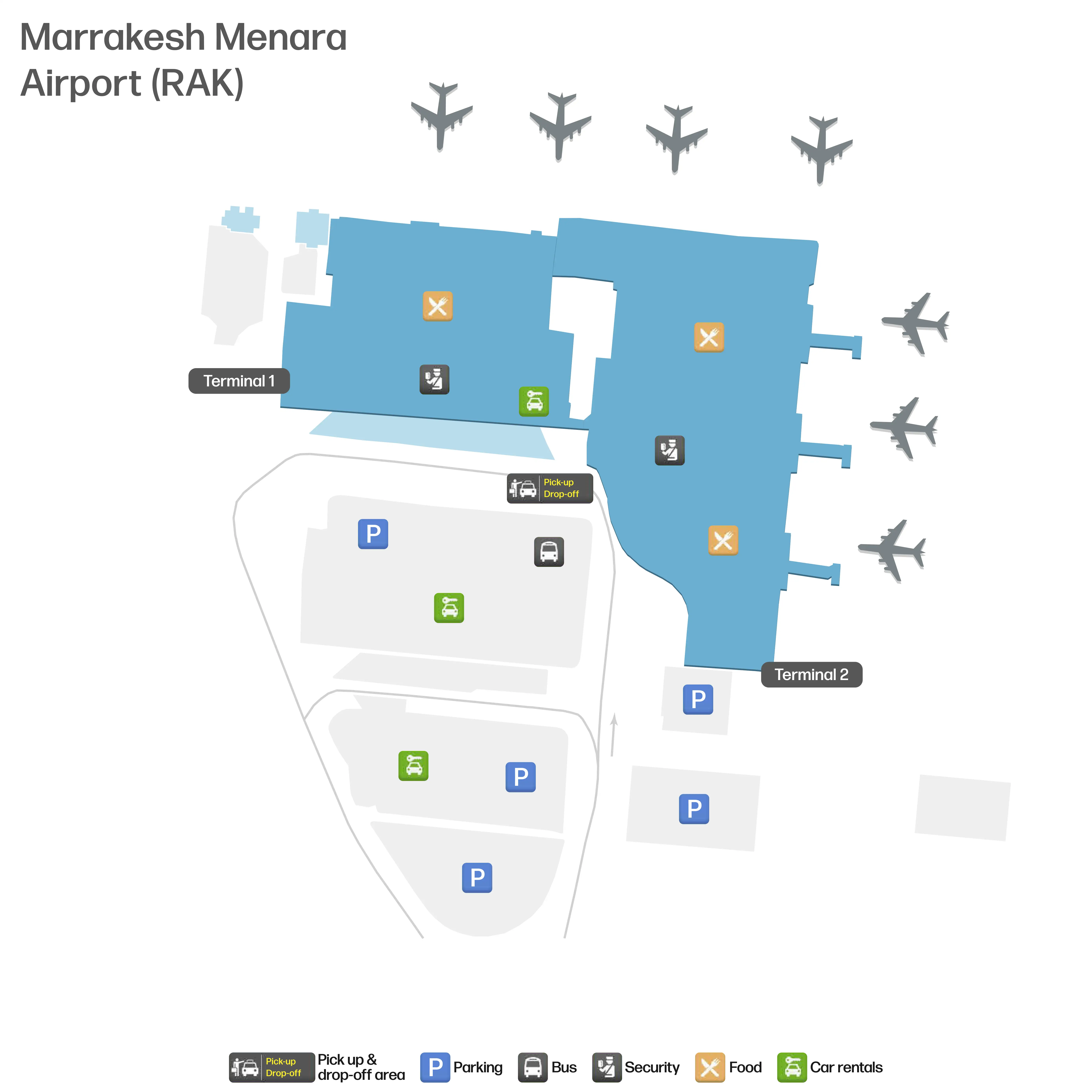
Marrakech Menara Airport Map (Most Up-To-Date)
Marrakech Menara Airport (RAK) runs as a compact, walk-only airport with two terminals and a single dominant passenger flow: curbside entry into a wide check-in hall, then a tightly sequenced chain of screening points that can stack into a “queue maze.” The overall footprint is broad and mostly single-level landside, then forces a vertical move into airside circulation. Inside the RAK airport complex, time risk comes from repeated checkpoints more than long walking distances.
Map Table
| Terminal | Key Airlines | Primary Function | Transfer Mode |
|---|---|---|---|
| Terminal 1 | Mixed international carriers | Departures processing core | Walk-only |
| Terminal 2 | Mixed / seasonal / overflow operations | Additional departures capacity | Walk-only |
| Airside A-Gates | Mixed outbound | Higher seating density, food court, lounge zone | Escalator up + walk |
| Airside B-Gates | Mixed outbound | Lower sub-concourse, crowding risk | Escalator down + walk |
Marrakech Menara Airport Map Strategy
- Plan for a queue maze: checkpoint stacking (door screening → check-in/document validation → security → passport control → re-check) is the real schedule risk.
- Navigate by anchors, not signs: terminal-door X-ray, the central check-in counter matrix, security belt exit, passport booths, duty-free funnel, then gate splits.
- Preempt the paper trap: treat printed boarding-pass readiness as a routing decision, not a last-second task near gates.
- Use failover paths on purpose: know where the back of immigration lines form on arrivals, where lost-luggage services sit before customs, and where the official prepaid taxi kiosk and pickup line start outside.
2026 Marrakech Menara Airport Map + Printable PDF
Current operations at 2026 Marrakech Menara Airport still hinge on manual, multi-stage processing: entry screening at the doors, document checks that can require printed paper, then security and passport control clustered so closely that one queue can spill into the next. A printable map matters most for predicting checkpoint order, spotting the re-check points that create surprise re-queues, and choosing the shortest paths between fixed anchors.
2026 Marrakech Menara Airport Map Guide
What is the exact walking route (and distance) from the terminal entrance X-ray screening to the main airline check-in counters?
Walking takes about 10–150 meters on a straight, single-level path across the ground-floor check-in hall, depending on where your flight’s counters are assigned that day. The route starts immediately after the terminal-door X-ray cordon and ends at the shared check-in counter matrix under the overhead flight screens.
| Route step | Walking path anchor | Distance |
|---|---|---|
| Clear entrance screening | Terminal entry doors → X-ray exit point | 0 m (start) |
| Cross the public hall | Walk straight into the open hall toward the overhead flight information displays | ~10–80 m (typical) |
| Reach assigned counter zone | Continue to the counter bank; extend to far-left or far-right periphery if your airline is placed there | up to ~150 m |
Where is the first passport control / exit-stamp checkpoint located relative to security screening (before or after), by walking path?
The first passport control / exit-stamp checkpoint is after security screening, and it begins almost immediately at the end of the security X-ray belts. The walking path runs from the security exit lanes straight into the emigration queue, with the back of the line forming only a few meters beyond where you collect your trays and bags.
The flow is security first (X-ray + any pat-down lane), then a short forward walk to the passport booths where officers check your passport and stamped paper boarding pass and add the exit stamp. Because the queue start sits right behind the belts, slowdowns at passport control can spill backward into the security area.
What is the exact location of the “additional document/boarding-pass check” point that forces passengers to re-queue near the departure gates?
A redundant document re-check sits about 5 meters past the primary passport control booths, immediately after you receive the exit stamp. The point is positioned so close to the immigration desks that passengers don’t enter an open corridor; they hit another short queue where an official visually verifies the fresh exit stamp before letting flow continue.
This re-check happens right after emigration, not deep in the concourse: walk forward from the last passport booth, stay in the same immediate channel, and you’ll meet the secondary verification point almost at once. A similar verification can also recur at the boarding door, where staff re-check the paper boarding pass and passport stamp again.
Where is the printed boarding pass / airline desk printing area located, and what is the shortest path to it from the terminal entrance?
The printed boarding pass printing point is the manned airline check-in desks in the ground-floor check-in hall, with no public self-service print kiosks inside the terminal. The shortest path mirrors the main check-in walk: clear the terminal-door X-ray, then walk straight across the open hall to your flight’s assigned counter bank under the overhead flight information displays.
Because counters are dynamically assigned, the distance varies by where your airline is placed that day: roughly 10 meters if your counter zone is central, and up to about 150 meters if it’s at the far-left or far-right edge of the hall. This is the only reliable “failover” location when you realize you need a paper pass or an ink/document stamp.
What is the exact walking distance from check-in to the security checkpoint, and which corridor/level changes (if any) does it require?
Walking takes about 50 meters from the main check-in counter matrix to the primary security checkpoint, with no level changes. The path stays on the ground floor and is mostly straight, running from the counter hall toward the security screening lanes anchored by the X-ray belts and tray tables.
After leaving the counter area, follow the main interior flow toward the security queue entrance rather than drifting toward side exits or arrivals-facing doors. The only meaningful “deviation” is queue geometry: stanchions and crowding can force a wider arc, but the structural route remains a single-level, short corridor approach into the security lanes.
Where is the arrivals immigration hall queue start point (the physical “back of the line”) relative to the arrivals exit from the aircraft corridor?
The back of the arrivals immigration line forms at the base of the descending stairs that drop you from the aircraft arrival corridor into the ground-floor immigration hall. The queue typically begins almost immediately where the stairs end, so the first “decision point” is the stair landing that feeds into the zigzag stanchions.
Arrivals commonly enter via a corridor that includes level changes, then funnels into that single hall. When multiple flights arrive together, the line can back up onto the stairs themselves, turning the stair base into the practical “queue start” landmark. Once you step into the stanchioned zigzags, lateral exit is difficult, so treat the stair base as the last easy place to check documents, regroup, or confirm you’re ready to commit to the line.
Which baggage reclaim belt area serves international arrivals, and what is the shortest route from passport control exit to the baggage belts?
International arrivals use the ground-floor baggage reclaim hall with the main carousel bank (a set of multiple belts in one hall), and the walk from passport control exit to the belts is under about 30 meters on a direct line. The route starts at the immigration exit channel and ends at the center of the carousel area in the same hall.
After clearing the passport booths, continue forward into the baggage hall without turning into public exits; the belts are within direct sightlines of the immigration processing area. The practical anchor is the carousel bank itself: once you see the first belt edge and the crowd clustering around it, you’re in the correct international reclaim zone.
Where is the lost luggage / baggage services (PIR) office located relative to the baggage reclaim exit (before or after customs)?
The PIR (lost luggage / baggage services) office is inside the baggage reclaim hall before customs, and you must use it before crossing the final customs exit. The key anchor is the carousel area: the PIR desk sits within the same secure baggage hall footprint, not out in the public arrivals lobby.
If you walk past the last carousel crowd toward the only public egress channel, the customs/X-ray point is the hard boundary. File the report, get your baggage tag details recorded, and leave with the PIR reference before you pass that checkpoint—because re-entry back into baggage reclaim from the public side is typically blocked.
Where is the final customs/X-ray checkpoint located on the path from baggage claim to the public arrivals hall exit?
The final customs/X-ray checkpoint sits directly on the single, unavoidable exit channel between the baggage reclaim hall and the public arrivals lobby. The walking path runs from the carousel area toward the exit doors, then funnels into the green/red channel split leading into the X-ray belt zone before the public doors.
From the baggage belts, follow the main outward flow to the only staffed egress; you’ll see the declaration channels and the inspection/X-ray point immediately before the doors that open into the arrivals meet-and-greet area. This is also the enforcement node where bags may be pulled for inspection, so it functions as the last hard stop before you’re released into the public hall.
Where is the official taxi kiosk / prepaid taxi ticket point located relative to the arrivals exit doors, and which door number/side is it nearest?
The official prepaid taxi kiosk is immediately outside the main arrivals exit, on the right-hand side as you step out onto the exterior plaza. The walking path is: clear the customs doors into the public arrivals lobby, walk straight to the primary exterior exit doors, then exit and turn right to the yellow-and-black “TAXI BOOKING kech.cab” kiosk.
A door number isn’t reliably posted or consistent enough to use as a fixed reference, so the usable location cue is the side: it’s nearest the right-hand side of the main arrivals exit frontage when facing outward from inside the terminal. The kiosk is positioned to be in near line-of-sight from the exit once you pivot right.
What is the exact pickup zone for prepaid taxis (the physical stand/line) after the kiosk, and what is the shortest walking route to it?
The prepaid taxi pickup line is the vehicle staging area up the adjacent ramp in the same exterior plaza, about a 20–30 meter walk from the kech.cab kiosk. The shortest route is a straight, line-of-sight walk: finish at the kiosk, turn toward the visible ramp and the queued taxis, then walk up to the stand where attendants match your ticket to a car number.
The stand functions as a single controlled queue rather than scattered curb pickups. Stay on the official path from kiosk to ramp and ignore unsolicited “helpers” trying to redirect you to off-system cars; the correct pickup zone is the organized line immediately beyond the kiosk area, not deeper into parking lanes.
Where are the departure gate waiting areas with the highest seating density located, and what is the shortest path from passport control to those seating clusters?
The highest seating density is in the first-floor A-Gates concourse (A1–A6), beyond the mandatory duty-free path. The shortest route from passport control is: clear the post-passport re-check, take the escalators/elevator up to the first floor, follow the forced duty-free walkway, then continue about 100–150 meters into the upper concourse where the main seating clusters and quieter lounge-style areas appear.
The key anchors are the escalator bank immediately after the ground-floor control sequence and the duty-free “funnel” you cannot bypass. Once you emerge into the upper concourse, the densest seating is concentrated around the A-Gates side near the food court and the calmer “quiet area,” rather than the lower, more crowded B-Gates sub-concourse.