Luis Munoz Marin International Airport Map (Most Up-To-Date)
Luis Muñoz Marín International Airport is a long, mostly linear terminal complex running west-to-east from Terminal A through the central Terminal B and Terminal C core to the more distant Terminal D. Landside roads split by level (departures vs arrivals), while airside corridors stitch concourses together after TSA. Within the San Juan hub airport grounds, the layout rewards “correct-first-choice” routing: the wrong USDA line, curb, or pickup zone can force a time-wasting backtrack.
Map Table
| Terminal | Key Airlines | Primary Function | Transfer Mode |
|---|---|---|---|
| Terminal A | JetBlue | JetBlue check-in, dedicated TSA | airside connector to Terminal B and Terminal C |
| Terminal B | American, Delta, United, Southwest, Spirit | main check-in hall, central TSA | walk to Terminal C, airside connector to Terminal A |
| Terminal C | Iberia, Avianca, overflow gates | international/overflow concourse, duty-free core | walk from Terminal B retail spine |
| Terminal D | Cape Air, Silver Airways, regional ops | far-east gates, thinner amenities | long airside walk from Terminal C and Terminal B |
Luis Muñoz Marín International Airport Map Strategy
- Treat USDA as the true starting line for checked bags: go there immediately after entering, then commit to airline counters and TSA.
- Use a wrong-choice penalty mindset: confirm you’re in a USDA x-ray line (not a counter queue) and pick the shortest line even if it means walking laterally first.
- Lock in curb logic before you roll luggage outside: arrivals vs departures level, then the exact pickup zone for rideshare or taxi to avoid outdoor backtracking.
- Keep a Plan B path: if one checkpoint or concourse feels overloaded, route through the central Terminal B and Terminal C core and use the post-security connector to reach the needed gate area.
2026 Luis Munoz Marin International Airport Map + Printable PDF
Current 2026 routing at Luis Muñoz Marín International Airport still centers on the landside USDA baggage inspection step for checked luggage before airline counters, plus highly variable line loads at check-in and TSA. Airside remains connected across Terminal A, Terminal B, and Terminal C, but Terminal D stays the “far walk” zone with fewer amenities. Lounge availability around Terminal C can be inconsistent during refurbishment periods, so maps matter for quick fallback positioning.
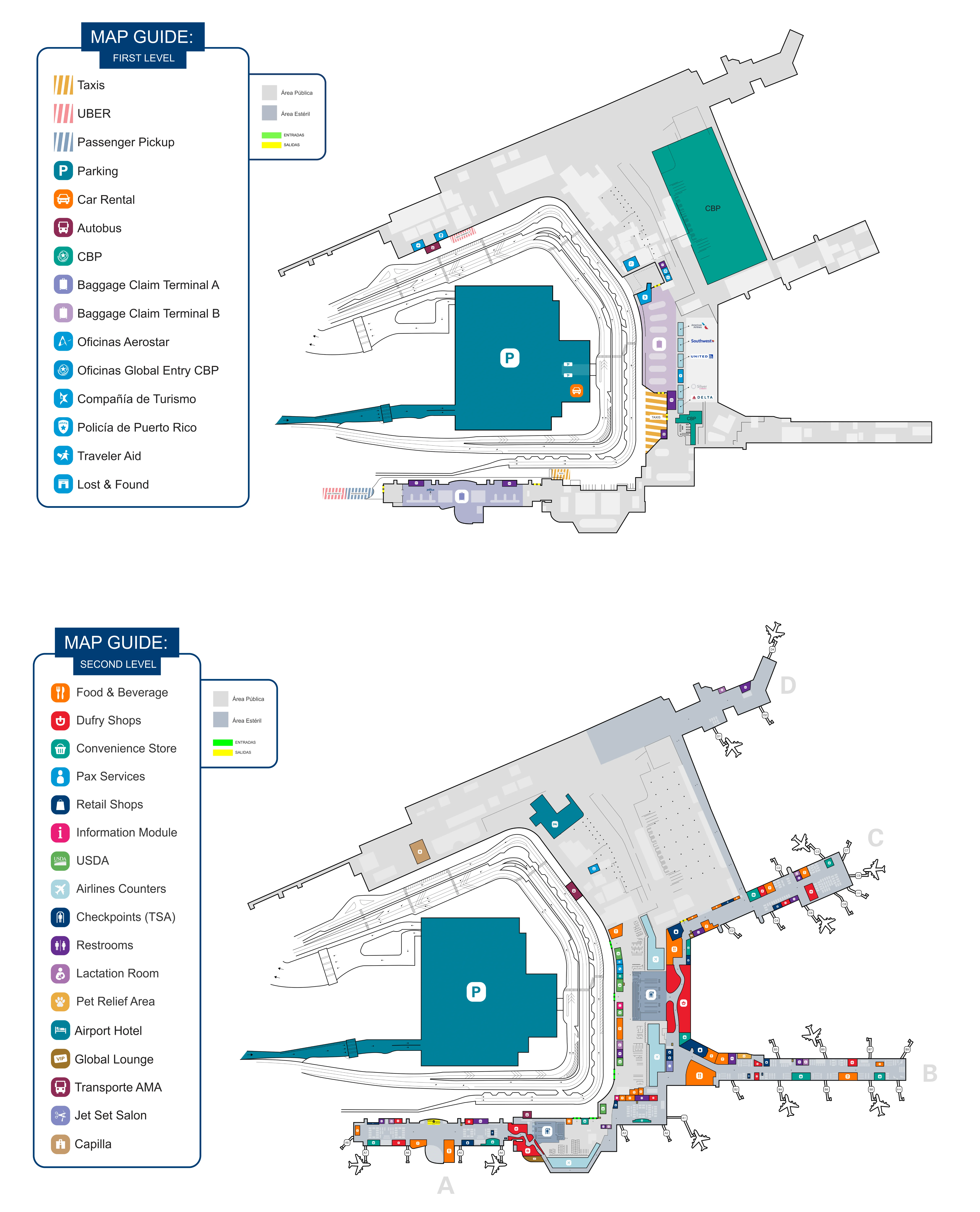
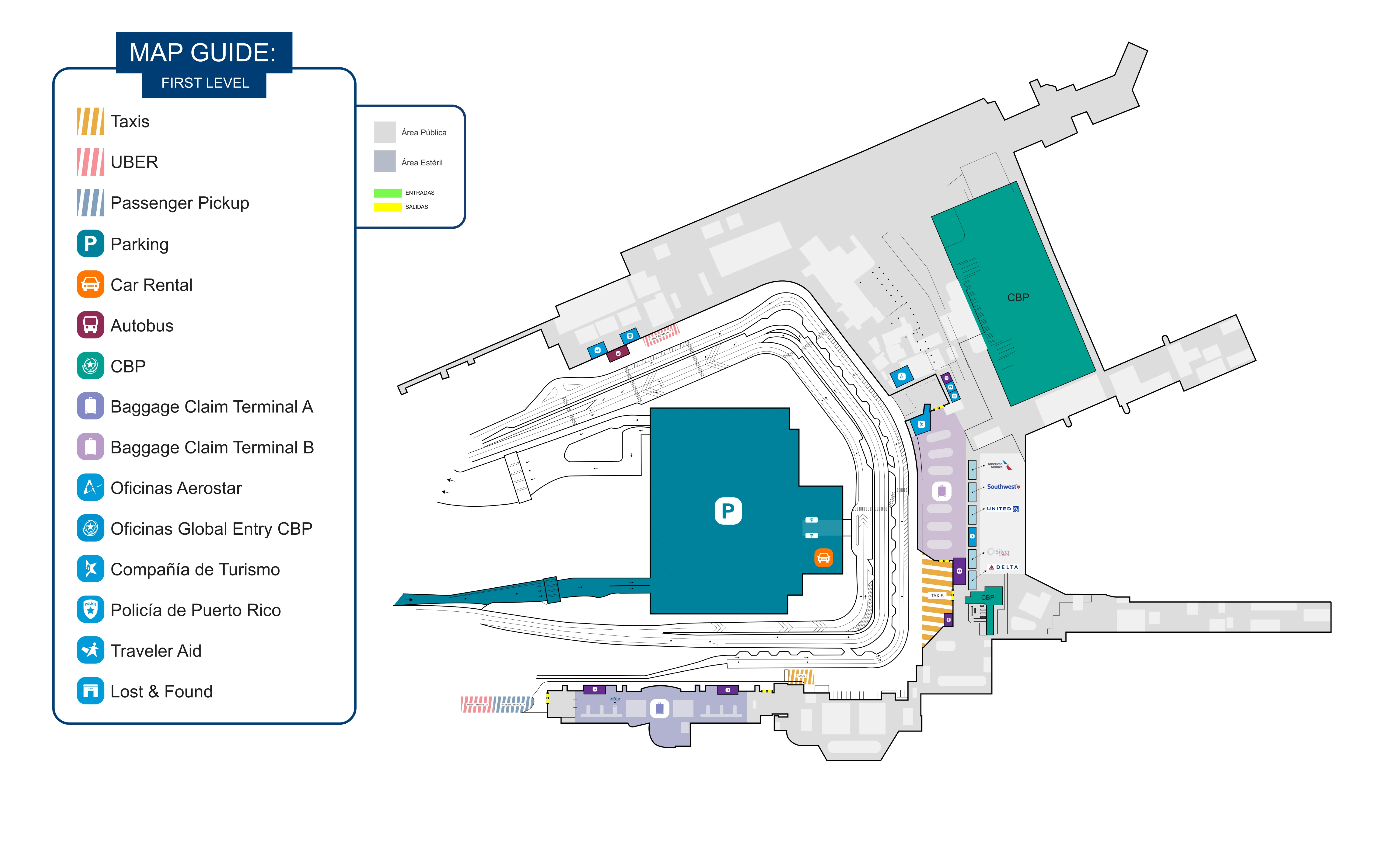
Luis Munoz Marin International Airport First Level Map 2025
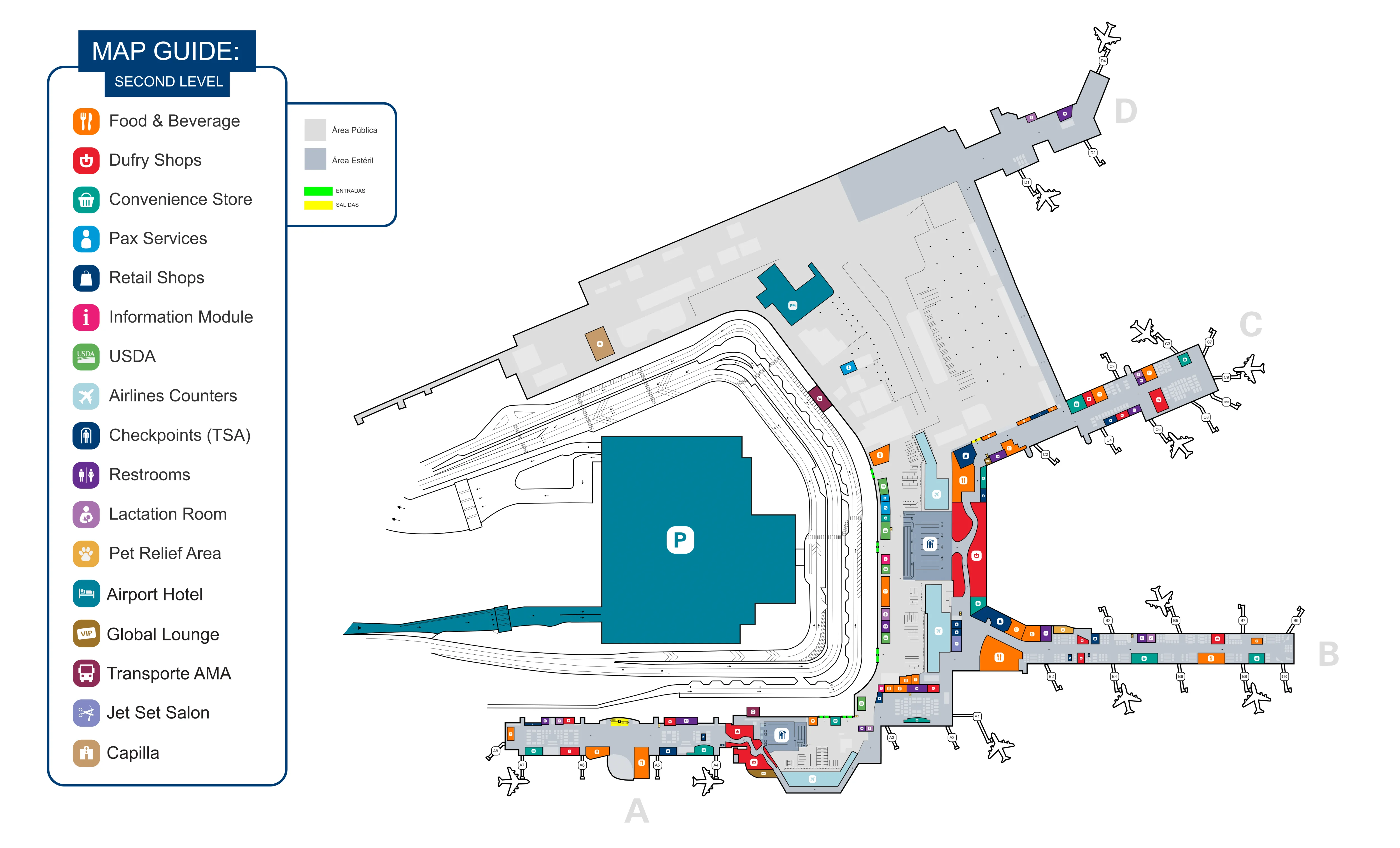
Luis Munoz Marin International Airport Second Level Map 2025
2026 Luis Munoz Marin International Airport Map Guide
What is the exact map location of the USDA baggage inspection station relative to the main airline check-in counters (show the shortest walking path)?
The USDA baggage inspection at Luis Muñoz Marín International Airport sits landside in the departures check-in hall, positioned between the public entrance doors and the airline ticket counter rows, so the shortest path is to hit USDA first and then walk straight into the counter zone. In Terminal A (JetBlue), it’s along the far-left wall relative to the main entrance; in Terminal B (main hall), USDA screening islands line the front interior wall before the counters.
From the departures curb, enter the terminal doors for your airline, then immediately scan for the USDA x-ray queue before joining any airline line. After your bag is stickered, walk directly forward to the closest bank of check-in kiosks/counters for your carrier, keeping to the same terminal segment to avoid cross-terminal backtracking.
What is the exact walking distance (in meters/feet) from the USDA inspection point to the nearest TSA checkpoint entrance used for departures?
Walking distance cannot be treated as a single fixed number at Luis Muñoz Marín International Airport because the nearest TSA checkpoint depends on which terminal’s USDA station you use (Terminal A versus Terminal B) and where you re-enter the check-in hall after the USDA x-ray. The shortest practical path is always USDA → nearest airline counter bank → the associated checkpoint entrance behind that check-in zone.
A workable map-reading method is to measure from the USDA x-ray exit point to the checkpoint queuing stanchions for that terminal: in Terminal A, route from the far-left USDA wall area to the rear security entrance of Terminal A; in Terminal B, route from the USDA island nearest your door to the central Checkpoint B entrance. Use the closest visible checkpoint sign (“Security / TSA”) as the anchor, not the retail spine, because detouring toward shops lengthens the walk and increases wrong-turn risk.
Where are the two USDA lines/entry points located on the map, and which one is physically closer to the largest cluster of airline counters?
The USDA line closest to the largest cluster of airline counters is the Terminal B departures-hall USDA screening area, because it sits directly in front of the airport’s main multi-airline counter banks. The other common USDA entry point is inside Terminal A, positioned off to the side and easier to walk past if you follow the JetBlue crowd straight ahead.
| USDA entry point | On-map location cue | Physically closer to the biggest counter cluster? |
|---|---|---|
| Terminal A (JetBlue) USDA line | immediately inside the departures entrance, along the far-left wall relative to the main doors, before the JetBlue kiosk/counter area | No — Terminal A is a single-carrier hall with fewer total counters |
| Terminal B (main hall) USDA line(s) | inside the large rectangular departures check-in hall, along the front interior wall between the entrance vestibules and the long rows of counters (American/Delta/United/Southwest/others) | Yes — this is the highest-density concentration of airline counters |
Where is the designated Uber/Lyft pickup zone on the terminal map, and what is the shortest indoor route from baggage claim exit doors to that pickup point?
The designated Uber and Lyft pickup is commonly shown and enforced as a designated rideshare area at Terminal D on the far eastern end of the terminal complex. The shortest indoor segment is simply getting from your baggage carousel to the nearest “Exit / Ground Transportation” doors for your baggage claim hall, because the Terminal D pickup approach is primarily an outside sidewalk walk.
From Baggage Claim in Terminal B, leave the carousel area and head to the closest curbside exit doors facing the arrivals roadway, then turn right outside and follow the sidewalk east toward Terminal D until you reach the marked rideshare zone. From Terminal A baggage claim, exit to the arrivals curb and continue east the same way. If your app pin forces Terminal D, don’t wait at the curb outside Terminal A or Terminal B—walk the corridor sidewalk to the Terminal D designated area so the driver can legally trigger pickup.
What is the exact curb/level (arrivals vs departures) shown on the map for rideshare pickup, and which doors/pole-number zone is closest to the primary curb frontage for major airlines?
Rideshare pickup uses the arrivals-level ground transportation curb, and Uber/Lyft commonly routes pickups to the Terminal D designated rideshare area rather than the curb directly outside Terminal B. The closest doors for most major-airline arrivals are the baggage claim exit doors in the Terminal B arrivals hall, but the closest compliant pickup point may still be Terminal D if the app geofences it.
| Scenario | Curb/level | Closest “start point” doors | Closest compliant pickup point |
|---|---|---|---|
| App pin shows Terminal D Rideshare | Arrivals level | Terminal B baggage claim curbside exits | Terminal D designated rideshare curb area |
| App pin allows Terminal B curb | Arrivals level | Terminal B baggage claim curbside exits | Terminal B arrivals curb pickup area nearest those exits |
What is the exact walking distance from the baggage claim carousel area to the taxi queue location shown on the map?
Walking distance is short and direct because the taxi queue is staged on the arrivals curb immediately outside the baggage claim exits, so the route is carousel → nearest curbside exit doors → taxi dispatch/queue. This is typically a minute-or-two walk in the same building zone, not a cross-terminal trek like the Terminal D rideshare scenario.
From your carousel, follow “Exit / Ground Transportation / Taxis” signs to the closest set of doors that open to the arrivals curb. Outside, look for the taxi dispatcher kiosk and the organized taxi line directly along that curb frontage. If you’re choosing between taxi and rideshare, the taxi queue’s key advantage is that it’s positioned right where you exit baggage claim—no long eastbound sidewalk walk.
Where is the consolidated rental car facility / rental car transport pickup shown on the map, and what is the shortest route from baggage claim to that pickup point?
The consolidated rental car facility sits in the parking garage structure directly across the arrivals roadway from the terminal, so the shortest route is a pedestrian walk—not a shuttle transfer for the major on-site brands. The key waypoint is the marked crosswalks leading from the arrivals curb to the garage entrance signed “Rental Car / Alquiler de Autos.”
Exit your baggage claim hall to the arrivals curb, then locate the nearest crosswalk straight across the roadway. Cross into the parking structure and follow the rental car signage to the ground/Level 1 counter area inside the garage complex. If you’re standing at the curb looking for a branded bus, you’re already losing time—the fastest path is across the street on foot.
Which on-map rental car counters (if any) are inside the terminal footprint, and where are they located relative to arrivals baggage claim?
Rental car counters are not typically inside the main terminal footprint at Luis Muñoz Marín International Airport for the major on-site agencies, because the primary counter cluster is staged in the parking garage complex across the arrivals roadway. Relative to arrivals baggage claim, the functional “counter area” is one pedestrian crossing away, accessed via the curbside exits and the nearest marked crosswalk.
From baggage claim, the correct sequence is exit to the arrivals curb, cross the road into the garage, then follow “Rental Car / Alquiler de Autos” signage to the counter level. If any smaller or off-airport brands use separate pickup procedures, they are usually handled as transport pickups rather than true in-terminal counters, so the map cue to trust is the garage-directed rental car signage—not a desk inside the baggage hall.
From the main TSA exit into airside, what is the exact walking distance to the farthest gate cluster (identify the gate range and route on the map)?
Walking typically runs about 900–1,200 meters (3,000–4,000 feet) from the main Terminal B security exit to the Terminal D far-east gate cluster used by regional operators like Cape Air and Silver Airways. The farthest point is the end of the Terminal D pier, beyond the Terminal C retail spine.
| Route segment (map-anchors) | Direction | Typical distance |
|---|---|---|
| Exit Checkpoint B → central airside retail spine | straight ahead | ~150–250 m / 500–800 ft |
| Retail spine → Concourse C junction (duty-free core) | eastbound | ~250–350 m / 800–1,150 ft |
| Concourse C junction → Terminal D corridor entrance | continue east | ~250–350 m / 800–1,150 ft |
| Terminal D corridor → farthest D-gates end | all the way to the pier end | ~250–350 m / 800–1,150 ft |
Where is the airside connector/corridor between concourse/terminal areas shown on the map, and what is the shortest route between the two most commonly-confused concourses?
The airside connector is the post-security corridor that links Terminal A to the central Terminal B and Terminal C airside core, letting you clear TSA at one checkpoint and still walk to gates in the other area. The shortest “most-confused” move is typically Terminal A gates to the Terminal C core, because JetBlue passengers often assume they’re trapped in Terminal A for food, lounges, or other gates.
From the main airside area after Terminal A security, follow signs toward Terminal B and Terminal C and stay on the continuous sterile-side hallway until you enter the Terminal B and Terminal C retail spine. From Terminal C back to Terminal A, reverse the same corridor and follow Terminal A gate signage at the split, using the checkpoint exit area as your orientation anchor rather than storefronts.
Where are the post-security food options located on the map, and which is closest (by walking distance) to the highest-density gate area?
Post-security dining is concentrated in the central Terminal B and Terminal C retail spine, with thinner options as you walk east toward Terminal D and more limited “food court” style choices in Terminal A. The closest reliable cluster to the highest-density gate area is the Terminal B and Terminal C core immediately after the main security exit, because it sits at the junction feeding multiple concourses.
Use the main TSA exit into airside as the anchor, then stay in the central corridor where duty-free and the primary restaurants are grouped before you commit to long walks toward the far ends. If you’re departing from Terminal D or the high-numbered Terminal C gates, grabbing food in the Terminal B and Terminal C core first prevents the amenity drop-off deeper in the eastbound gate corridors.
Where is The Club SJU / main lounge located on the map, and what is the shortest walking route from the primary TSA exit to that lounge entrance?
The Club lounge is positioned airside near the Terminal C sector, close to the central Terminal B and Terminal C retail corridor, with access that can involve going up a level by elevator depending on which entrance is in use. The shortest route starts at the main Terminal B security exit, then follows the airside retail spine toward Terminal C until you reach the lounge’s marked entrance area.
From Checkpoint B, walk straight into the central airside corridor, then continue in the Terminal C direction toward the duty-free and restaurant cluster until you see The Club signage near the Terminal C entrance zone. If the lounge entrance is on an upper floor, use the nearest elevator bank at that Terminal C junction rather than walking deeper into the concourse and doubling back.