London Luton Airport Map (Most Up-To-Date)
London Luton Airport (LTN) is a single-terminal, vertically stacked layout with a compact landside plaza that fans out into three competing modes: Luton DART (to Luton Airport Parkway), the Airport Bus Station/coach bays, and the paid Drop-Off/Pick-Up road loop. At London’s Luton hub, the footprint is tight, but the access geometry is unforgiving: critical paths are short in meters yet easy to miss at decision nodes.
Map Table
| Terminal | Key Airlines | Primary Function | Transfer Mode |
|---|---|---|---|
| Terminal 1 | easyJet, Wizz Air, Ryanair, TUI | point-to-point departures, UK/Schengen arrivals | Luton DART, Airport Bus Station, Express Drop-Off, Long Stay shuttle |
London Luton Airport Map Strategy
- Treat Luton DART as a separate building: exit Arrivals, commit to the right-forward line across the canopy plaza, and ignore bus-bay clustering unless you’re explicitly going to the Airport Bus Station.
- Budget the Luton Airport Parkway transfer as a vertical interchange: bridge walk plus lift/escalator descent; a “2-minute rail connection” is not physically realistic at peak waves.
- Resolve coach stand confusion by using the bus station information screens and bay numbers; “Stands R & S” behaves like a ticket code, not a reliably signed curb label.
- Drive defensively at the Drop-Off Zone split: the fee is incurred once you pass the barrier/gantry, and the minimum re-attempt loop is a full one-way circulation back out toward the Holiday Inn/Ibis roundabout.
2026 London Luton Airport Map + Printable PDF
Operational flow at LTN still hinges on three make-or-break interfaces: the outdoor walk to the Luton DART building, the vertical transfer at Luton Airport Parkway (bridge + lifts/escalators), and the monetized road system around the Express Drop-Off/Priority Pick-Up. Printing a 2026 map helps lock in the correct decision forks before you hit the plaza signage clutter.
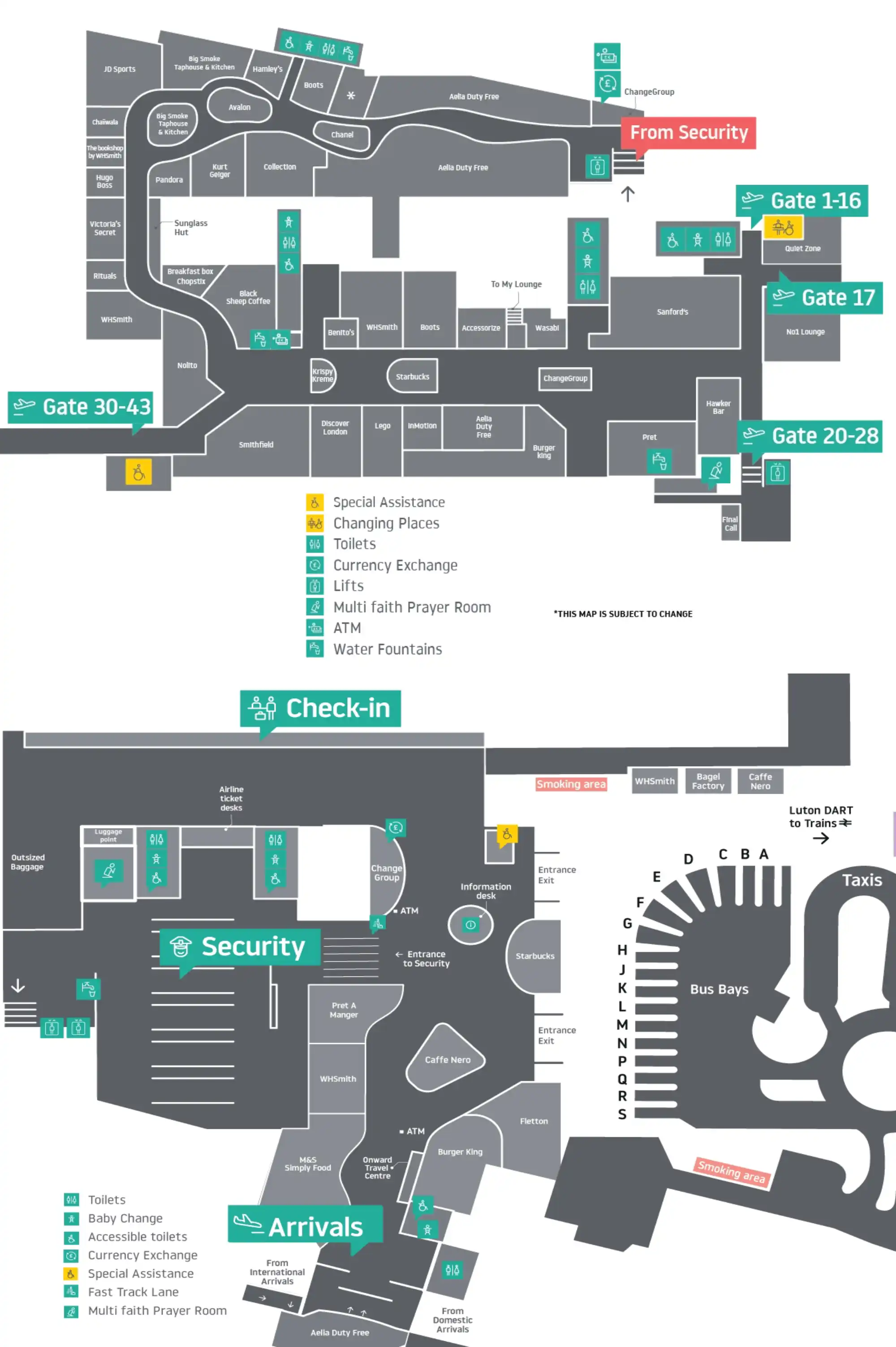
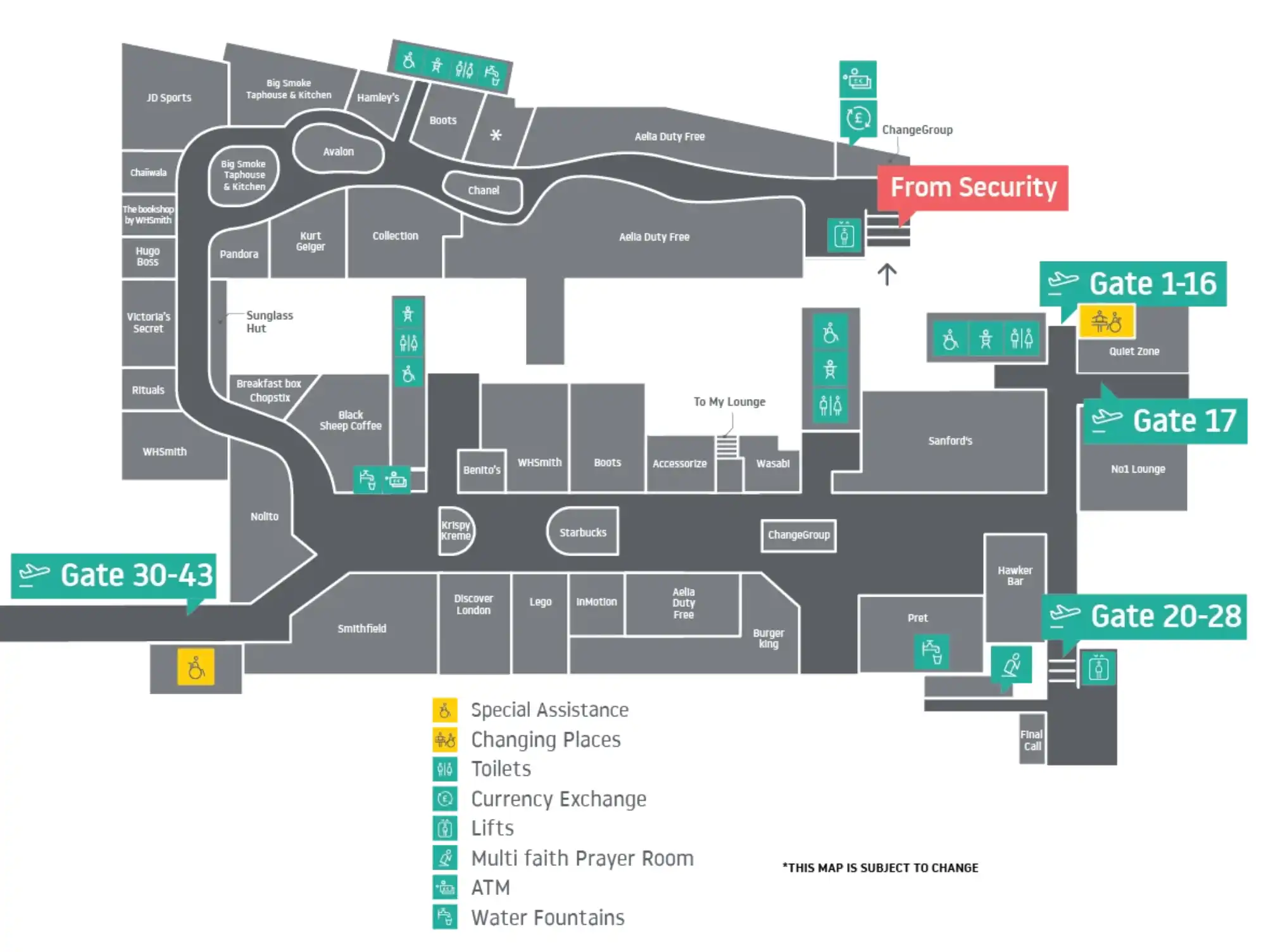
London Luton Airport Airside Map 2025

London Luton Airport Airside Map 2025
2026 London Luton Airport Map Guide
Where is the Long Stay “FREE drop-off” shuttle stop (pickup point) and what is the walking distance from the terminal to that shuttle stop?
The Long Stay “FREE drop-off” shuttle stop at the terminal is Bus Bay B, about 120–150 meters from the main terminal exit doors. From Arrivals/terminal frontage, cross the canopy-covered plaza toward the bus-bay island and target the bay signed for “Car Park Shuttles,” using the same zebra crossings used for the Airport Bus Station.
Walking from Long Stay to the terminal is not a viable option because the Long Stay Car Park sits roughly 2 km away on roads without pedestrian sidewalks. The only practical link is the shuttle, which typically runs about every 20 minutes, so the “free” option behaves like a park-and-ride with built-in dwell time.
Where are the payment signage points for the drop-off system located on-site (at entry/exit/terminal frontage), and what is the last decision point before you’re committed?
The last decision point is the approach to the Express Drop-Off / Pick-Up entry barrier and ANPR gantry, where large totem signs display the fee before you pass the commitment line. Once you’re in the segregated entry lane, you cannot reverse out without completing the loop, so the “read-and-decide” moment is effectively at the entry signage.
| Signage / payment point | Where you’ll see it | What it means operationally |
|---|---|---|
| Entry totem pricing signs | At the Drop-Off entry barrier/gantry | Final chance to abort before fee commitment |
| Payment machines | Near pedestrian exits of the zone and near exit barriers | Pay after parking/walking in, not at a staffed booth |
| Exit barrier area | On departure from the zone | No cash booth; don’t assume barrier lift = no charge |
| Online payment prompts | On-site messaging + follow-up behavior | Deadline pressure (pay by midnight the following day) to avoid PCN risk |
Where is Fast Track Security physically located versus Standard Security, and what is the walking distance from the main check-in hall to each entrance?
Fast Track Security is immediately to the right of Standard Security on Level 1, within about 5–10 meters of the main security entrance line. From the center of the ground-floor check-in hall, walk roughly 50 meters to the central escalators/elevators, go up to Level 1, then walk another ~20 meters to the security entrances (about 70–100 meters total, excluding queue time).
The main failure mode is joining the Standard “herd” queue after reaching Level 1. Use the escalator crest as your anchor: Standard is straight ahead; Fast Track is the right-hand entrance beside it, not a separate area elsewhere in the terminal.
From Security exit, what is the walking distance to the furthest gate zone used for bus-boarding (the area that forces crowding/line stacking)?
Walking is about 800–900 meters from the post-security central departure hub to the furthest gate zone at the distal end of the piers (commonly referenced by Gate 43), and airport signage indicates around a 15-minute walk. From the Security exit, you’re forced through the Aelia Duty Free path into the main Departure Lounge; from that central lounge, follow the main corridor and onward pier signage toward gates in the 30–43 range.
Crowding and line stacking typically spike when flights are called and the gate area is narrower than the main lounge, causing passengers to cluster into pinch points at the end of the pier. Treat “Go to Gate” as immediate action: lingering in the lounge turns the 15-minute vector into a missed-boarding scenario.
Where are the nearest women’s toilets post-security relative to the main departure lounge choke point, and what is the shortest path to them?
The nearest women’s toilets post-security are just beyond the Duty Free exit in the central Departure Lounge, close to the main Flight Information Display Screens (FIDS). From the Security exit, follow the forced Aelia Duty Free path into the lounge, then continue straight ahead about 20 meters toward the large screens to reach the toilet block.
The choke point is the Duty Free “maze,” which you cannot bypass, so the shortest path is simply staying on the main retail corridor until it releases you into the open lounge. The usual wrong-turn is drifting sideways into the first retail aisles after Duty Free; use the FIDS screens as the anchor and keep a straight line until you’re behind/adjacent to them.
What is the exact walking distance from Baggage Reclaim to the Taxi rank / rideshare pickup point, and where are the decision forks that cause wrong-turns?
The Taxi rank is about 50–80 meters from the Arrivals exit outside Baggage Reclaim, while rideshare pickup commonly pushes you to the Priority Pick-Up Zone at roughly 400 meters. After exiting Customs into the Arrivals hall, the key fork happens at the terminal frontage signage split: “Taxis” directs left/immediate curbside; “Pick Up Zone” directs straight/right across the plaza.
The most common failure mode is ordering an Uber/Bolt and waiting at the taxi rank, where rideshare vehicles can’t legally stage without entering paid access. If you’ve booked rideshare, commit to the “Pick Up Zone” routing immediately after exiting, before you get absorbed into the taxi-queue crowd at the left-hand curb.
Where is the clearest landside re-entry point (Arrivals → Departures) for self-transfer, and what is the walking distance between those doors?
The clearest landside re-entry is the direct concourse walk from the Arrivals egress into the main ground-floor hall toward the Departures/check-in side, and the door-to-door distance is about 50–80 meters (under 100 meters). Exit Arrivals into the public greeting hall, walk straight out of the corridor, then turn right into the main check-in hall, using the overhead “Departures” signs as your anchor toward the escalators.
There is no airside transit for connections, so every self-transfer is a full landside reset: Arrivals → baggage → customs → walk → check-in → upstairs to security. The distance is short, but the process time is not—queue volatility is the real constraint, not the meters.