London Gatwick Airport Map (2025-2024)
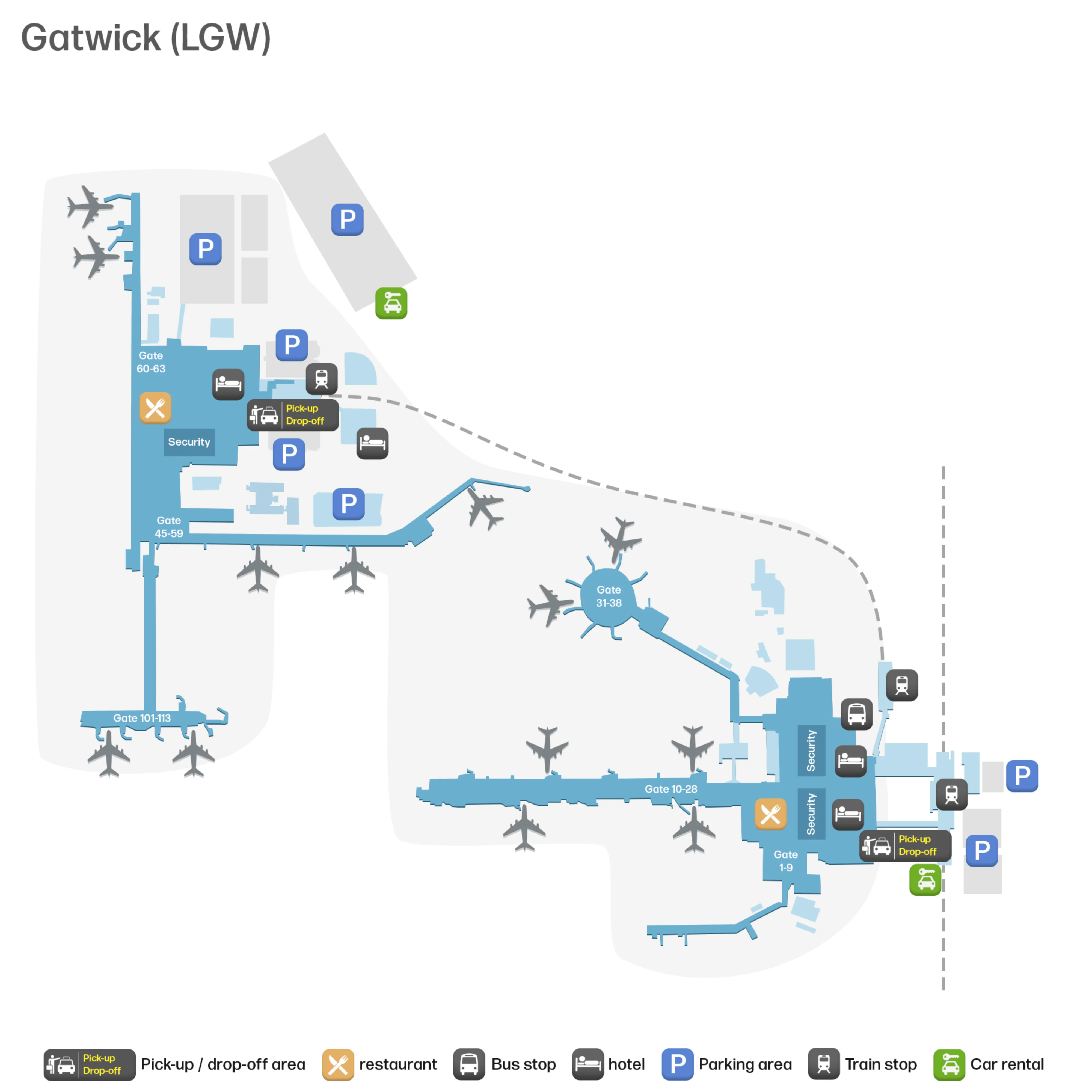
London Gatwick Airport is a two-node layout: South Terminal sits on top of the rail station as the main intermodal “core,” while North Terminal operates as a separate processing unit about 1.2 km away across taxiways and apron. The terminals are linked only by a landside automated shuttle, which means terminal choice drives your entire path. Within London’s secondary airport hub, both terminals feed long, linear piers that can turn “close on the map” into a long end-to-end walk.
Map Table
| Terminal | Key Airlines | Primary Function | Transfer Mode |
|---|---|---|---|
| South Terminal | Mixed short-haul, leisure | Rail-station core, primary intermodal | Landside shuttle, rail concourse |
| North Terminal | Mixed short-haul, leisure | Remote processor, long-pier gates | Landside shuttle, elevated interchange |
London Gatwick Airport Map Strategy
- Treat North↔South as two different airports: station → correct terminal → security → gate; never assume an airside shortcut exists.
- Lock the shuttle nodes early: from the station barriers, the shuttle is the immediate right-turn target; walking straight into the atrium creates an instant backtrack penalty.
- Solve security entry friction by mapping the last “landside decision”: check-in zone → nearest vertical route (up if required) → the correct security access point, before you queue.
- Budget far-gate time like a connection: security exit → mandatory retail flow → pier/bridge commitment → 100-series or end-of-pier gates, with walking distance as the main missed-flight risk.
2026 London Gatwick Airport Map + Printable PDF
2026 operations still hinge on the same constraint: North and South are separate terminals with a landside-only shuttle connection, so there’s no secure airside terminal transfer. The map matters most at the station-right-turn decision, the shuttle arrival level change at North Terminal, and the long post-security walks to far gates (notably the 100-series in North and the long piers in South).
2026 London Gatwick Airport Map Guide
What is the exact walking distance (meters/feet) from Gatwick Airport rail station exit into South Terminal to the inter-terminal shuttle entrance?
Walking distance is approximately 50–100 meters (about 165–330 feet) from the station ticket barriers into South Terminal to the inter-terminal shuttle entrance. The shortest path is the immediate right turn after you clear the barriers, staying on the same concourse level as the station. During peak arrivals, passenger density in the retail atrium can slow the last few meters, so treat it as a 1–2 minute segment even though the distance is short. If you walk straight ahead into the main South Terminal atrium, you’ve passed the decision point and will need a quick backtrack to reach the shuttle doors.
In North Terminal, what is the exact walking distance from the main check-in hall to the security entrance (shortest signed route)?
Walking distance is approximately 50–150 meters (about 165–490 feet) from North Terminal’s main check-in hall to the security entrance via the shortest signed route. The security access point is on the same departures level as check-in, so this is primarily a straight concourse walk rather than a multi-level transfer.
From the central check-in atrium, follow the overhead “Departures” / “Security” signs toward the boarding-pass access gates at the edge of the check-in hall. Check-in positions closest to the central spine of the hall land you near the ~50 m end; positions toward the outer ends of the hall push it toward ~150 m. The time risk here is queue density at the security entrance, not the walk itself.
From North Terminal security exit, what is the exact walking distance to Gate 101 (or the furthest 100-series gate shown on the terminal map)?
Walking distance is typically over 900 meters (about 3,000+ feet) from the North Terminal security exit to Gate 101, with the furthest 100-series gates extending beyond that. The route length comes from stacking multiple long segments: the duty-free exit path, the departures lounge traverse, the Pier 6 approach corridor, the 197-meter Pier 6 taxiway bridge, and then the pier walk to the specific gate.
| Segment anchor | Direction of travel | Distance cue |
|---|---|---|
| Security exit → World Duty Free flow | Mandatory winding retail path | Time sink, not optional |
| Departures lounge → Gates 101–113 signs | Main lounge spine to Pier 6 approach | Long straight traverse |
| Pier 6 bridge crossing | Taxiway bridge | 197 m fixed length |
| Pier 6 entry → Gate 101 | Along the pier | Gate-dependent extension |
If your boarding pass shows a 100-series gate, plan this like a mini-connection: once you commit to the bridge and pier, backtracking costs minutes and there are fewer “reset” landmarks than in the main lounge.
At North Terminal approach, which exact roadway split / lane decision leads to the standard passenger drop-off (not coaches, not “approved operators”)?
The left-hand lane at the key pre-forecourt split leads to standard passenger drop-off for North Terminal. The right-hand lane is the trap lane: it is designated for coaches and “approved operators,” and once you commit to it, the options to recover without looping the airport roads are limited.
On the final approach into North Terminal, stay left as the roadway bifurcates and follow signs for passenger drop-off / short-stay access rather than the faster-moving right lane. The decision happens before the terminal forecourt, so pick your lane early, then follow the short-stay/drop-off routing into the public passenger set-down area rather than the operator-only roadway.
From the Thameslink platforms, which exact signed route (lift/escalator + corridor) delivers you into South Terminal departures/check-in?
The signed route is platforms → central escalators/lifts → ticket barriers → right turn past the shuttle entrance → moving walkways toward the check-in hall. From the Thameslink platforms, the fastest way up is the main escalator/lift banks that rise directly to the station concourse at the barrier line, which is also the South Terminal landside level.
After you pass through the barriers, keep to the right-hand flow: the shuttle doors sit immediately adjacent, and the departures/check-in route continues along the same concourse. Use the travelators to cover the lateral distance into the main check-in zones (A–K). If you’re looking for security at this stage, don’t: you’re still on the check-in level, and security is reached after check-in via the internal vertical transition up to the security level.
Where exactly does the inter-terminal shuttle arrive inside North Terminal (level + nearest landmark), relative to the departures/check-in hall?
The inter-terminal shuttle arrives at the North Terminal Interchange on an elevated platform level (often described as a mezzanine/Level 1), not directly in the main departures/check-in hall. The nearest functional landmark is the shuttle interchange corridor and lift/escalator lobby that you must use immediately on arrival.
From the shuttle doors, the shortest onward path is to take the escalators or lifts up into the North Terminal departures/check-in level (Level 2). If you have a trolley or heavy bags, the lift bank at the shuttle interchange becomes the practical chokepoint because the shuttle unloads in waves and everyone needing step-free access funnels into the same vertical core. Relative to the check-in hall, think “one level below/offset, then up into the atrium.”
At North Terminal arrivals, what is the exact walking distance from the arrivals doors to Express Pick-Up (or the primary pickup zone shown on-site maps)?
Walking distance is approximately 250–400 meters (about 820–1,310 feet) from North Terminal arrivals doors to Express Pick-Up. The pickup point is not curbside at the arrivals doors; it’s embedded in the multi-storey car park structure (commonly referenced as Car Park 6), which is why the walk feels longer than people expect.
After you exit arrivals, follow the “Car Parks” / “Express Pick-Up” signs out of the terminal onto the covered pedestrian link. Continue across the forecourt walkway into the car park and then navigate to the signed Express Pick-Up area (level signage is the key landmark once you enter the structure). With luggage, treat it as a 5–8 minute walk even if you move steadily.
What is the exact walking distance from South Terminal arrivals to the coach station / long-distance bus bays (shortest pedestrian route)?
Walking distance is approximately 200–300 meters (about 660–985 feet) from South Terminal arrivals to the coach station via the shortest pedestrian route. The coach station sits on the Lower Forecourt (Level 0), so the distance includes a mandatory descent from the arrivals level.
Exit customs into the South Terminal arrivals hall, then follow the overhead “Coaches” / “Bus & Coach Station” signs to the designated lift bank or the ramped/moving-walkway descent. After you drop to the lower level, continue out to the outdoor coach bays. The main failure point isn’t the length—it’s missing the correct down-route and staying on the rail-level concourse, which feels “right” but doesn’t reach the bus bays.
What is the exact landside walking route (named corridors/landmarks) from South Terminal security exit area back to the inter-terminal shuttle (the backtrack path if you’re in the wrong terminal)?
No airside inter-terminal transfer exists at Gatwick, so the backtrack route requires exiting the secure zone and walking landside to the shuttle on the station concourse. From the South Terminal security exit area, you must follow the signed “Way Out” flow to landside, then navigate toward “Trains” and “North Terminal Shuttle” rather than deeper into check-in.
From the landside concourse, aim for the rail-station side landmarks: the main retail atrium, the “Meeting Point,” and the cluster of high-visibility units like Costa Coffee and WHSmith. Keep tracking “Trains” until you reach the station barrier line area, then peel to the shuttle entrance positioned immediately adjacent to the rail concourse (near the gates). This is a same-level walk once you’re back landside, but it’s easy to overshoot into the ticket-barrier queues if you follow “Trains” too literally.
From South Terminal security exit, what is the exact walking distance to the furthest-numbered gate/pier shown on the South Terminal map?
Walking distance is up to about 780 meters (roughly 2,560 feet) from South Terminal security exit to the furthest pier-end gates, with some door-to-door measurements feeling closer to ~900 meters depending on the mandatory retail pathing. The longest pure-walk trek is typically to the distal end of the long piers (for example, the far end of Pier 2 such as Gate 28, or the far end of Pier 3 such as Gate 38).
The walk starts with the forced flow out of security through the departures retail zone, then continues along the main airside spine toward the correct pier. Travelators help on parts of the route, but the risk is still time: a pier-end gate can take 10–15 minutes at a normal pace, longer with kids, carry-ons, or congestion. If your boarding card shows a 90-series “bus gate,” the walking distance to the holding area may be shorter, but the bus-boarding process adds its own closure-time pressure.
At North Terminal, what is the exact walking distance from Short Stay parking pedestrian access into the terminal to the check-in hall?
Walking distance is typically a 4–6 minute covered walk from North Terminal Short Stay parking pedestrian access into the terminal check-in hall. The route runs via the dedicated link bridge from the multi-storey car parks into the terminal’s departures/check-in level.
From your car park lift core, you rise to the bridge level, cross the enclosed pedestrian bridge over the approach road, and enter the terminal near the main atrium/check-in hall on the departures level. “Premium Short Stay” compresses this to an about 2-minute access path because it’s positioned for faster bridge-to-terminal entry, but standard Short Stay is the longer 4–6 minute covered traverse. The main non-walking constraint to watch is over-height vehicle rejection at the barrier, which can force a time-costly reroute.
From Gatwick Airport station ticket barriers, where is the closest terminal entry point into South Terminal (exact door/corridor location)?
The closest South Terminal entry point is the station ticket barrier line itself because the rail concourse is structurally inside the South Terminal landside footprint. Once you pass through the barriers, you are already in the South Terminal public concourse with no external doorway or separate “terminal entrance” to find.
From that barrier line, the terminal space opens immediately into the landside retail atrium and circulation corridor that feeds check-in zones and the shuttle. The practical “entry point” for navigation is the moment you clear the barriers and choose direction: straight ahead takes you into the main South Terminal concourse toward check-in; an immediate right turn takes you to the North Terminal shuttle entrance on the same level.