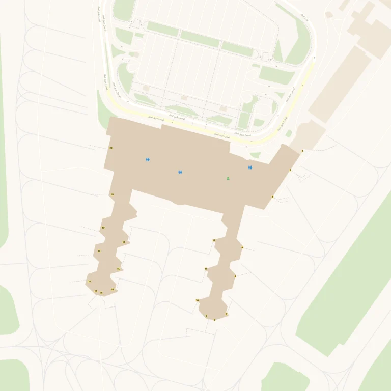
Jomo Kenyatta International Airport Map (Most Up-To-Date)
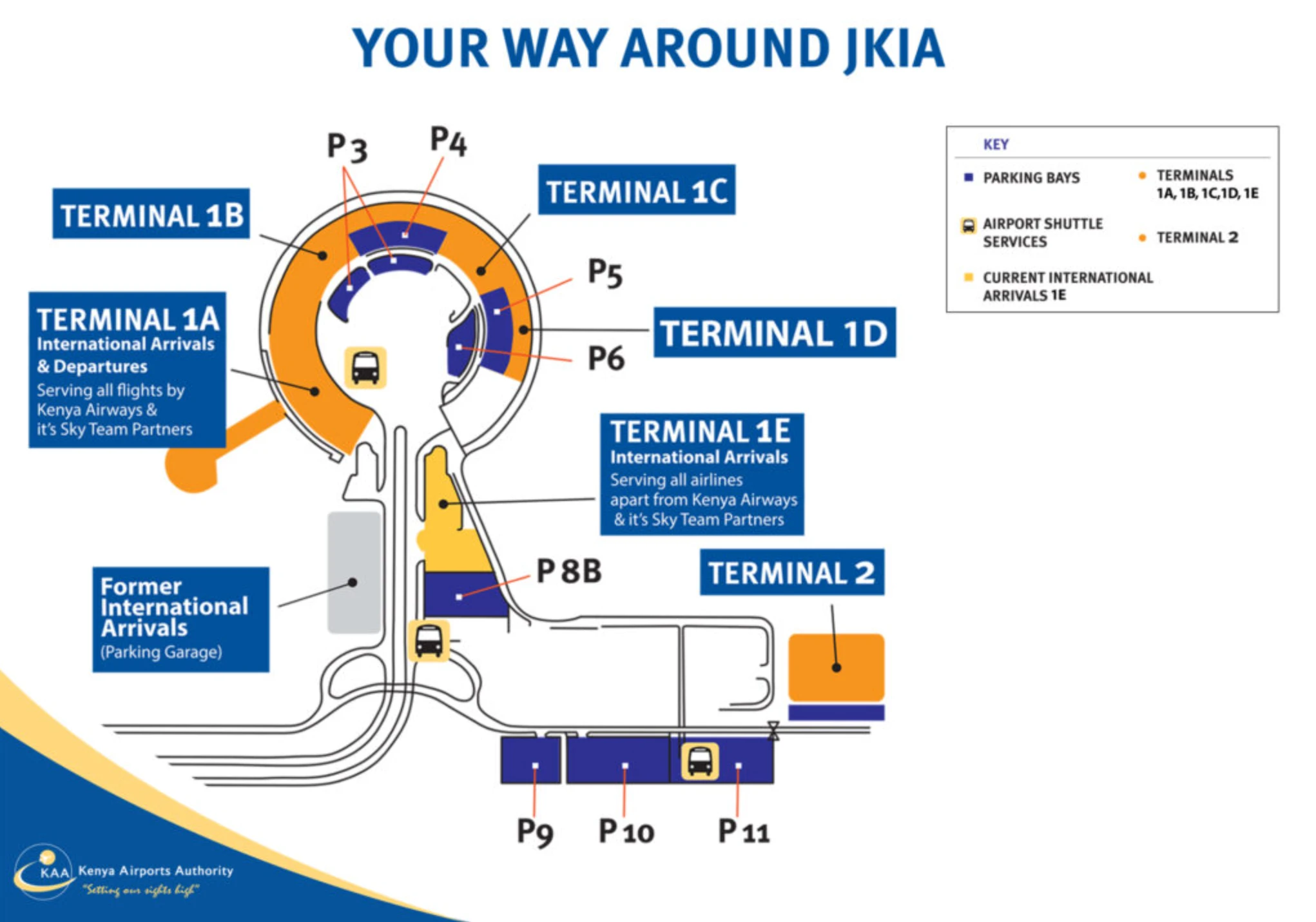
Jomo Kenyatta International Airport (NBO) is organized around a semi-circular Terminal 1 complex that wraps a central curb/parking island, with Terminal 1 split into operational silos (1A, 1B, 1C, 1D, and 1E Arrivals) that look connected but behave like separate systems. Movement feels simple on the curb, but transfers can silently force extra checkpoints or wrong-process queues. Terminal 2 sits apart as a satellite with no sterile connection, outside the main Nairobi airport hub’s terminal arc.
Map Table
| Terminal | Key Airlines | Primary Function | Transfer Mode |
|---|---|---|---|
| Terminal 1A | Kenya Airways, SkyTeam | intl departures, hub transfers | airside (within 1A) |
| Terminal 1B | Emirates, Lufthansa | intl departures | airside (to 1C), landside (to 2) |
| Terminal 1C | Qatar Airways, RwandAir | intl departures | airside (to 1B), landside (to 1E) |
| Terminal 1E | mixed arrivals feed | intl arrivals extraction | landside only |
| Terminal 2 | LCC, regional | satellite terminal | landside only |
Jomo Kenyatta International Airport Map Strategy
- Treat Gate 13 as the make-or-break junction: stay on the upper-level transit path and enter transit screening near the Turkish Airlines Lounge cues before any descent toward immigration.
- Assume repeated screening: budget for at least one unexpected re-screening layer when switching Terminal 1 sub-units, and treat Terminal 1 ↔ Terminal 2 as a full landside reset.
- Use curbside geometry to avoid misrouting: anchor movements on the central pickup islands opposite the terminals, not on “looks-connected” internal corridors.
- Avoid the rough-pavement transfer: prioritize shuttle/taxi between Terminal 1 and Terminal 2 instead of the 1 km roadside sidewalk segment.
2026 Jomo Kenyatta International Airport Map + Printable PDF
Operational flow at 2026 JKIA still hinges on “phantom connectivity” inside Terminal 1: you can often see adjacent zones, but routing rules push passengers into specific chokepoints and repeated screening layers. Terminal 2 remains a hard-transfer satellite with no airside corridor from Terminal 1, so the map matters most at the Gate 13 decision node, the Terminal 1E customs exit, and the curbside shuttle islands.
2026 Jomo Kenyatta International Airport Map Guide
What is the exact walking distance (meters) from Terminal 1E arrivals to Terminal 1C check-in via the shortest legal passenger route?
The shortest legal walking distance is about 400 meters, using the landside frontage sidewalk from the Terminal 1E arrivals exit to the Terminal 1C check-in entrance.
The path starts at the Terminal 1E sliding exit doors after customs, continues along the covered curbside walkway that follows the arc of the Terminal 1 frontage road, and ends at the public departures entry doors for Terminal 1C check-in. The key constraint is that this is not a sterile/airside connector—any “inside-looking” link is operationally blocked—so the route must stay landside through the Arrivals Courtyard edge and the terminal frontage sidewalk.
Where is the airside transfer corridor inside Terminal 1 that connects toward Terminal 2, and what is its precise map position relative to the main security checkpoint?
There is no airside transfer corridor from Terminal 1 to Terminal 2, so the only “connection” point is the landside public exit that leads out to the inter-terminal shuttle/taxi stops.
Terminal 2 is operationally isolated from the Terminal 1 sterile zone, meaning any T1→T2 transfer requires exiting the secure area, clearing immigration/customs as applicable, and re-entering security at Terminal 2. On maps, the relevant position “relative to the main security checkpoint” is downstream of it: you must go out through the public landside doors to the curb, then walk to the central pickup island/shuttle stop opposite the Terminal 1 frontage rather than following any interior corridor.
From Gate 13, what is the exact map path that lets a transit passenger bypass the immigration queue without crossing the border-control entry line?
Missing the Gate 13 transit split forces you into immigration, and JKIA does not provide a return path back to airside without completing border control.
From Gate 13, stay on the upper-level arrivals corridor and take the signed “Transit/Connecting Flights” diversion before any escalators down toward immigration/baggage reclaim. The usable path is the lateral turn at the Gate 13 junction toward the transit security screening point, anchored by the Turkish Airlines Lounge cue (located between Gate 13 and Gate 4). Clearing the transit X-ray injects you back into the departures-side concourse serving the Terminal 1B/1C gate lounge area, letting you continue to connecting gates without ever crossing the border-control entry line.
What is the precise location of the Kenya Airways transit/transfer desk inside Terminal 1A (landmark + nearest gate/zone), as shown on terminal maps?
The Kenya Airways transit/transfer desk is airside in Terminal 1A immediately after the transit/secondary security screening point, positioned by the Gate 15 zone (sometimes referenced around the Gate 7 junction in older numbering).
On the mapped flow, it sits at the central concourse bifurcation where arriving transit passengers emerge from the carry-on X-ray checkpoint and are funneled toward the main Gate 14–24 pier. The most reliable triangulation is “past secondary screening” and “before the deeper gate run,” making the Gate 15 area the closest consistent gate anchor for finding it without drifting into the wrong queue.
What is the exact walking time range (based on distance) from Terminal 1A transit processing to the Precision Air terminal/gates, following the mapped pedestrian route?
Walking takes about 4–5 minutes end-to-end (active walking), staying entirely airside within Terminal 1A from transit processing to the Precision Air gate area.
The mapped route runs straight down the Terminal 1A pier from the transit/transfer processing node (immediately after the transit/secondary security screening and near the Kenya Airways transfer desk) toward the gate cluster used for regional departures. Using the pier-length distance metric of roughly 300 meters to the far end of the concourse yields ~4.2 minutes at 1.2 m/s; with crowd friction and brief pauses, the practical range is 5–10 minutes without any terminal change.
Where are the screening choke points located between arrivals exit and curbside/ground transport (the ‘belongings scan’ area), and what is the shortest map route that avoids doubling back?
The main belongings-scan choke point is the customs X-ray line at the single exit of the Terminal 1E baggage reclaim hall, and once you clear it you should not double back because re-entry is blocked.
The shortest route is linear: baggage carousel area → Green Channel/customs inspection funnel → luggage X-ray belt at the hall exit → straight through the sliding doors into the public Arrivals Courtyard → continue directly out to the curbside pickup island opposite Terminal 1E. The key map anchor is that the scanners sit immediately before the only public exit doors from baggage reclaim, so any attempt to detour to restrooms/ATMs after the X-ray risks forcing a re-route and losing time in the densest congestion zone.
What is the exact outdoor walking distance for the inter-terminal transfer segment described as ‘outside,’ and which curb/sidewalk line on the map corresponds to the ‘rough pavement’ section?
The outdoor “outside” inter-terminal transfer distance is about 1,000 meters between the Terminal 1 complex and Terminal 2, and the rough-pavement section is the roadside sidewalk line that follows the main airport loop road between those two precincts.
On the mapped geometry, this is not the covered Terminal 1 frontage walkway used for 1A/1B/1C/1E adjacency; it is the longer landside vector that starts at the Terminal 1E/1D end of the arc (near the roundabout/curb interface) and continues along the loop-road verge toward the Terminal 2 access road. This is the segment exposed to traffic and weather and is the primary source of “outside + rough surface” transfer friction.
Where are the terminal-to-terminal shuttle/taxi pickup points located (by terminal letter/number), and what is the shortest walking route from each terminal exit to that pickup point?
Terminal-to-terminal shuttle/taxi pickup points sit on the central median pickup islands opposite the terminal frontage, with one primary node opposite Terminals 1A–1D and a second node opposite Terminal 1E arrivals.
| Terminal exit | Pickup point location | Shortest walking route |
|---|---|---|
| 1A | central island opposite 1A–1D | exit doors → cross drop-off lane → central island |
| 1B | central island opposite 1A–1D | exit doors → cross drop-off lane → central island |
| 1C | central island opposite 1A–1D | exit doors → cross drop-off lane → central island |
| 1D | central island opposite 1A–1D | exit doors → cross drop-off lane → central island |
| 1E | central island opposite 1E | arrivals exit → cross service lane → 1E pickup island |
| 2 | curbside stand at Terminal 2 frontage | exit doors → curbside pickup line |
Where is the closest lounge option to the primary long-haul departure gates in Terminal 1, and what is the exact walking distance from that lounge to the gate cluster (mapped)?
The closest lounge-to-gate pairing is the Swissport Aspire Lounge in Terminal 1B, about 10–20 meters from the long-haul gate holding area around Gate 11.
For Terminal 1A long-haul operations, the Kenya Airways Pride Lounge is the closest, positioned near Gate 17 with a walk of under 50 meters to Gate 17 and about 150 meters to the far end of the Gate 14–24 cluster. The key map anchor is gate adjacency: Aspire is directly opposite Gate 11 in 1B, while Pride sits centrally in the 1A pier near the mid-gate zone (Gate 17), minimizing backtracking before boarding.
Where are the power/charging stations concentrated in the main international waiting areas, and what is the closest charging point to the highest-density departure gate zone (mapped)?
Power is concentrated in Terminal 1A’s main gate seating rows around Gates 17–20, where outlets are integrated into seating beams and the most reliable charging is closest to the densest departure gate zone.
In the Terminal 1A concourse, the nearest charging point to the highest-density gate area is the under-seat/between-seat AC/USB outlets in the central seating banks near Gates 17–20, adjacent to the Pride Lounge zone. In Terminals 1B and 1C, charging is sparse and often unreliable in public seating; the most consistent mapped charging alternatives are the paid lounges (Swissport Aspire Lounge in 1B and the Turkish Airlines Lounge cue area near the Gate 13/4 junction), plus café/restaurant seating zones rather than gate benches.
What is the shortest mapped route from international arrivals to the airport hotel access corridor (on-airport hotel/near-terminal), and what is the walking distance?
Walking is about 1,900 meters from Terminal 1E international arrivals to the Four Points by Sheraton Nairobi Airport via Tower Avenue, and there is no dedicated pedestrian hotel corridor integrated into the terminal map.
The mapped route starts at the Terminal 1E arrivals exit doors (post-customs), turns onto the main airport exit road alignment (Tower Avenue), and continues past the control-tower/cargo-side frontage toward the hotel access. This is a roadside transfer on a vehicle-dominant artery with intermittent sidewalks, so the practical “shortest mapped route” is the road-edge path rather than an internal connector. The operationally normal solution is the hotel shuttle rather than walking.
Archive Jomo Kenyatta International Airport Map
Below are all historical map versions for Jomo Kenyatta International Airport. Each year includes the official map available for that period, presented as both WebP and PDF.
2024-2026 Jomo Kenyatta International Airport Map (Official 2024 Edition)