Hong Kong International Airport Terminal 2 Map (Most Up-To-Date)
Terminal 2 (T2) at Hong Kong International Airport is a long, multi-level landside block on the east side of the Terminal 1 (T1) core, separated by the Airport Express/central transport spine and linked by interior bridges and vertical circulation. The footprint stretches deeper than legacy T2 because of the new Coach Hall, so “straight across” often means “across, then down.” Within Hong Kong’s primary airport hub at Chek Lap Kok, T2 currently behaves more like a transport-and-processing headhouse than a gate terminal.
Map Table
| Level / Zone | Primary Use | Key Connections | Fast Orientation Cue |
|---|---|---|---|
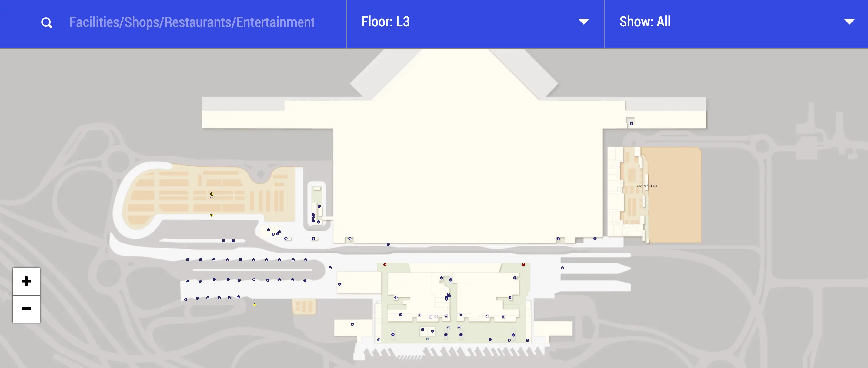
| L3 | Coach Hall | Central atrium to AEL spine | Bays 20–26 mainland/Macau zone |
| L5 | Future check-in / departures landside | Link bridges to T1 | “Across to T1” sightline at central void |
| T1 interface | Security / APM access | East Hall transfer nodes | E1/E2 above APM egress |
Hong Kong International Airport Terminal 2 Map Strategy
- Treat “Terminal 2” as a label for zones, not a guarantee of gates; lock in your target outcome first (T1 security, APM, Coach Hall) before you start walking.
- Sequence matters more than distance: if your path involves transfer security plus APM, commit to the correct order early so you don’t add an extra down-up loop at the wrong station bank.
- Defuse SkyPier anxiety immediately: SkyPier is airside-only, so there is no “short walk” to any T2 public doorway—plan a legal route via T1 processing if you must change sides.
- Win the decision nodes: at bridges, atrium edges, and level changes, follow named nodes (East Hall, West Hall, AEL/Trains to City, Coach Hall) instead of “Terminal 2” arrows alone to avoid wrong-way forks.
2026 Hong Kong International Airport Terminal 2 Map + Printable PDF
2026 operations hinge on phased commissioning: the T2 Coach Hall is the live public anchor, while flight functions are still staged toward a broader reopening window. The practical rule is that boarding flows remain anchored in Terminal 1 and its APM network, with T2 acting as a landside intake point that feeds you back to the T1 processing core.
2026 Hong Kong International Airport Terminal 2 Map Guide
What is the exact walking route from Terminal 2 check-in hall to the Terminal 1 departures security entrance?
Walking goes from T2 Level 5 (check-in/departures hall) across the central link bridge over the Airport Express spine, then up into T1 Level 7 to the main departures security portals behind the check-in aisles. This is the direct landside cross-terminal move that avoids committing into any T2-linked airside flow.
Start in the T2 check-in hall and walk to the central atrium/void where you have a sightline across to Terminal 1. Take the nearest North or South link bridge labeled for Terminal 1 and cross the span over the train/central concourse. On the T1 side, follow “Departures / Security” to Level 7 and continue to the rear of the check-in rows where the main security entrances sit (the large portals behind the Aisles A–K area).
Where is the Terminal 2–linked transfer security checkpoint located relative to the APM station (which direction, which level, and which entry point)?
Transfer security is stacked above the APM egress in Terminal 1 East Hall, reached by going up from the APM platform to Level 5 and entering the E1/E2 transfer security area at the top of the escalator bank. That vertical “up-from-APM” move is the functional T2-linked transfer funnel in the current flow.
After arriving on the APM at T1 East Hall (from Midfield or SkyPier), follow the exit stream off the platform toward the escalators directly ahead. Ride those escalators up to the transfer level and look for the Transfer Area entry labeled E1/E2 (East Hall). The checkpoint sits immediately off that escalator landing—above the train doors rather than down a corridor—while the alternative stream nearby leads to Immigration/Arrivals instead of transfer screening.
What is the exact APM ride sequence (station-to-station order) required to go from Terminal 1 to the Midfield Concourse (MFC) when the flow requires clearing transfer security at Terminal 2?
You don’t clear transfer security at Terminal 2 in the current flow; transfer screening happens at Terminal 1 (E1/E2 in East Hall or W1 in West Hall) before you ride to Midfield. The APM sequence to MFC is East Hall → West Hall → Midfield Concourse once you’re back on the departures-side APM platform.
| Step | Node | What to follow | Result |
|---|---|---|---|
| 1 | T1 East Hall arrivals-side APM exit | Escalators up to Transfer Area E1/E2 | Clear transfer security |
| 2 | T1 East Hall departures-side APM (same East Hall zone) | Signs for “APM / Midfield” | Board correct departures APM |
| 3 | T1 West Hall station | On-train stop | Stay onboard |
| 4 | Midfield Concourse station (Gates 201–230) | Exit to concourse | Arrive at MFC |
What is the walking distance (meters) from the SkyPier Transfer Building to the nearest Terminal 2 public access point (shortest pedestrian path)?
No public walking route exists, so the shortest pedestrian path is not applicable because SkyPier is airside-only and Terminal 2 public access is landside. The only way to reach any T2 public doorway from SkyPier requires processing through Terminal 1’s immigration boundary first.
SkyPier functions as a restricted transfer facility connected back to the terminal complex by APM, not by corridors or sidewalks. To get to landside public areas, you must take the APM to Terminal 1 East Hall, then follow the landside process (immigration and arrivals exit) before you can walk across the landside connector toward Terminal 2. Any attempt to “walk to Terminal 2” from SkyPier fails at the legal and physical security barrier long before distance becomes a meaningful metric.
Where is the Mainland/airport coach station entrance in relation to Terminal 2, and which door/level is the fastest entry?
The coach station is the Terminal 2 Coach Hall on Level 3 (arrivals level), reached fastest by going straight to the central atrium vertical cores and dropping down to L3 rather than roaming on the upper departures levels. For most users, the “entrance” is the open concourse transition into the Coach Hall ticketing/waiting zone, not a curbside door.
From inside Terminal 2, aim for the central atrium/void and follow signs for “Coach Hall” down to Level 3 using the main escalator or elevator bank beside the core retail/ticketing zone. If you’re coming from Terminal 1 or the Airport Express spine, cross into the T2 side of the central connector first, then descend to L3 and you’ll emerge into the Coach Hall concourse near the ticket counters. Within the hall, the mainland/Macau services cluster around Bays 20–26, which is the quickest landmark to confirm you’re in the right zone.
What is the walking distance (meters) from the Terminal 2 coach station area to the Airport Express station access (shortest indoor route)?
Walking is about 180–220 meters on the shortest fully indoor path, depending on which coach bay you start from inside the Coach Hall. The route is a straight traverse through the hall to the central atrium, then across to the Airport Express access at the T1/T2 spine.
From the Coach Hall concourse on T2 Level 3, walk toward the central circulation hub (the main escalator/elevator bank beside the ticketing zone) and continue toward the “Trains to City / Airport Express” signs. If you’re dropped at a deeper bay, you’ll first walk the length of the Coach Hall to that hub (roughly 80–120 m), then cross the central connector to the Airport Express interface (about 100 m). The critical constraint is that the entire connection stays indoors—going outside is the wrong-way move even if it feels “closer.”
Where is the baggage storage facility referenced as “Terminal 2 Level 3” located on the map (nearest landmark, lift/escalator bank, and corridor)?
The “Terminal 2 Level 3” baggage storage is currently a phantom reference in this redevelopment phase, with the active left-luggage function operating in Terminal 1 Level 5 (Arrival Hall A) instead of an accessible T2 L3 counter. When people follow legacy T2 L3 cues today, they typically hit Coach Hall frontage or construction hoardings rather than a storage counter.
The workable landmark set for finding the real storage is the T1 Arrivals ecosystem: go to Terminal 1 Level 5 and locate Arrival Hall A, then look for the S.F. Express-operated baggage storage counter area within that hall. If you’re standing on the T2 side at Level 3, your strongest “you’re in the wrong place” signal is being pulled toward Coach Hall bays and bus ticketing; that zone is the current operational anchor on T2 L3, not public left-luggage.
What is the shortest indoor route from Terminal 2 baggage storage to the taxi stand / ground transportation pickup zone (with the specific exit point)?
Terminal 2 Level 3 baggage storage is not the operational pickup point in this phase, so the shortest working route starts from the active left-luggage counter in Terminal 1 Level 5 (Arrival Hall A) and ends at the Ground Transportation Centre taxi lanes. That path stays indoors and uses the main GTC ramp as the exit interface.
From Terminal 1 Level 5 Arrival Hall A (left-luggage/S.F. Express counter area), walk toward the center of the arrivals hall and locate the wide, sloping ramp signed for the Ground Transportation Centre. Go down the full length of the ramp without exiting outside at any intermediate curb doors. At the bottom, you’ll arrive at the taxi stand split into the red (Urban), green (New Territories), and blue (Lantau) lanes. The specific exit point is the Ground Transportation Centre ramp landing where the lanes begin.
Which post-security food cluster is closest to the APM/transfer path that feeds Terminal 2-related transfer flows, and what is the shortest walking route to it?
The closest post-security food cluster is the Terminal 1 East Hall Level 7 dining zone directly above the transfer-security/APM node. That cluster sits on the shortest deviation from the transfer path because it’s primarily a vertical move, not a long concourse walk.
Exit transfer security in T1 East Hall and orient to the central atrium void immediately ahead. Take the first escalators up one level to Level 7, where the East Hall dining cluster is positioned above the APM egress and security flow. This is the lowest-risk “eat without losing your way” option because you can keep the APM/security landmark in the same vertical stack while you grab food, instead of walking toward West Hall or out along gate corridors.
What is the walking distance (meters) between the Terminal 2 transfer security exit and the APM platform entrance used to continue onward?
Walking is about 50–80 meters in the transfer-security-to-APM connection segment, with most of the movement being a one-way vertical descent rather than a long horizontal corridor. This link behaves like a sterile connector designed to push you straight from screening back into the APM system.
After you exit the transfer security lanes, you’ll hit the escalator bank almost immediately (typically within a few dozen steps). Take that escalator down toward the APM level and continue forward to the platform entrance/edge area, which is only a short flat walk at the bottom. The key operational detail is commitment: once you take that descent, there are no meaningful detours for shops or waiting areas inside this connector, so do bathrooms/food before you enter the security-to-APM funnel.
Where are the primary wayfinding choke points between Terminal 2 and Terminal 1 (the specific forks/decision nodes where travelers most commonly choose the wrong direction)?
The main choke points are the Airport Express/central spine platform exits, the T1–T2 link-bridge decision at the central atrium, and the airside split between SkyBridge walking routes versus APM routes. These are the places where a single wrong turn adds a full backtrack because levels and functions diverge fast.
On the Airport Express side, the fork is the platform/ticket-barrier exit choice where habit pulls people toward Terminal 1 even when they need “Terminal 2 / Coach Hall.” At the terminal interface, the fork is at the atrium edge where you either commit across the link bridge to the opposite terminal or get pulled deeper into the building you’re already in, which is how “I’ll just find it inside T2” time-loss happens. Airside, the fork is confusing the SkyBridge (walk to North Satellite gates) with the APM (ride to Midfield/SkyPier), because both are “going to another building” but only one matches Midfield/SkyPier flows.
What is the shortest mapped route from the Terminal 2 arrivals-side public area to the SkyPier ferry check-in / counter area (exact corridor sequence)?
No valid corridor sequence exists because SkyPier ferry check-in is not accessible from Terminal 2 landside public areas; SkyPier is restricted to Air-to-Sea or Sea-to-Air transit passengers. The shortest “route” is a redirection to public ferry terminals in town, not a walk inside the airport.
From Terminal 2 public arrivals/Coach Hall side, any “SkyPier” attempt runs into the airside/immigration firewall: you cannot walk landside into the SkyPier transfer building or its ferry counters. The workable alternative is to go to the Airport Express/MTR access at the central spine and travel to a public ferry terminal (for example, the China Ferry Terminal in Kowloon or the Macau Ferry Terminal area in Sheung Wan), or use a taxi from the Ground Transportation Centre. If you’re seeing signs for Immigration or Transfer Areas, you’re already in a different process stream than SkyPier allows for landside-origin passengers.