Helsinki Airport Map (Most Up-To-Date)
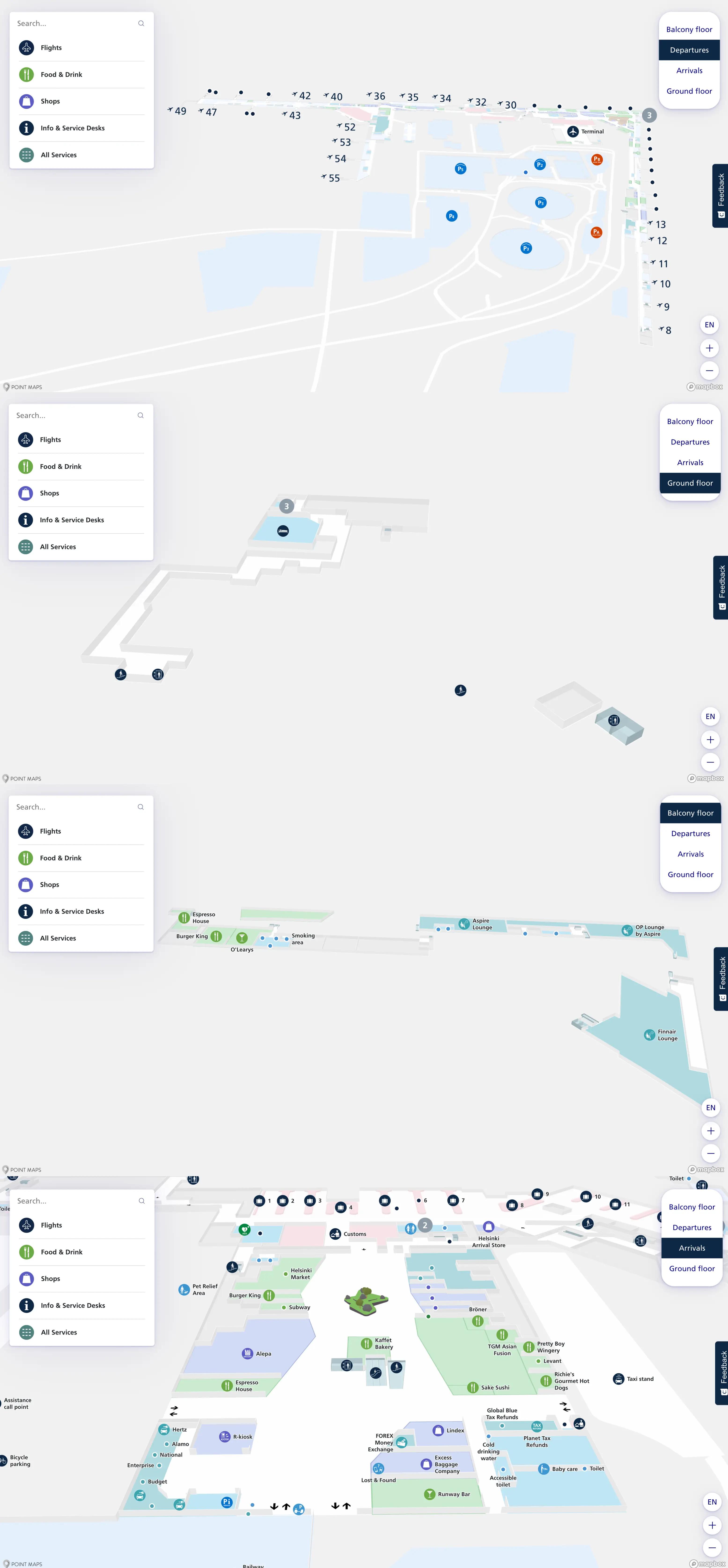
Helsinki Airport is a single-roof terminal with a wide central “hinge” and two long wings that form a chevron/V shape. Landside (check-in/arrivals) sits at the apex, with security feeding into a central airside spine (Aukio retail core). Schengen gates run down the older west wing (low gate numbers), while non-Schengen gates extend deep into the long-haul pier (37–55). Within Finland’s main Helsinki hub, walking distance is predictable; queue chokepoints aren’t.
Map Table
| Terminal | Key Airlines | Primary Function | Transfer Mode |
|---|---|---|---|
| Single terminal | Finnair | Schengen + non-Schengen under one roof | Walkways, travelators |
| West wing | Nordic short-haul operators | Domestic + Schengen (low gates) | Long corridor walk |
| Central hinge | Mixed carriers | Security exit, Aukio core, distribution node | High-density retail spine |
| Non-Schengen pier | Long-haul mix | Gates 37–55, passport control interface | Linear pier walk |
Helsinki Airport Map Strategy
- Treat the security exit, passport control (between Gates 36–37), and the non-Schengen pier (37–55) as your three hard checkpoints; everything else is secondary.
- Assume “hidden minutes” if your inbound shows remote-stand/bus handling; the critical fix is identifying the bus drop-off node and the fastest escalator path back to Level 2 flow.
- Use the map to pre-commit to worst-case gate walks (west wing low gates ↔ far non-Schengen gates) so a long transfer feels like a measured route, not a surprise.
- At every decision split, prioritize corridor labels for “Transfers” versus “Baggage Claim/Exit,” because the wrong descent to Arrivals forces a full landside loop and security re-entry.
2026 Helsinki Airport Map + Printable PDF
Helsinki Airport remains a consolidated, single-terminal airport, with the security exit feeding directly into the Aukio commercial spine and the Schengen/non-Schengen “diaphragm” sitting between Gates 36–37. The operational risk for 2026 connections is less about building complexity and more about variable time penalties at security, passport control (EES-era processing), and occasional remote-stand bus injections.
Helsinki Airport Departures Map 2025
Helsinki Airport Ground Floor Map 2025
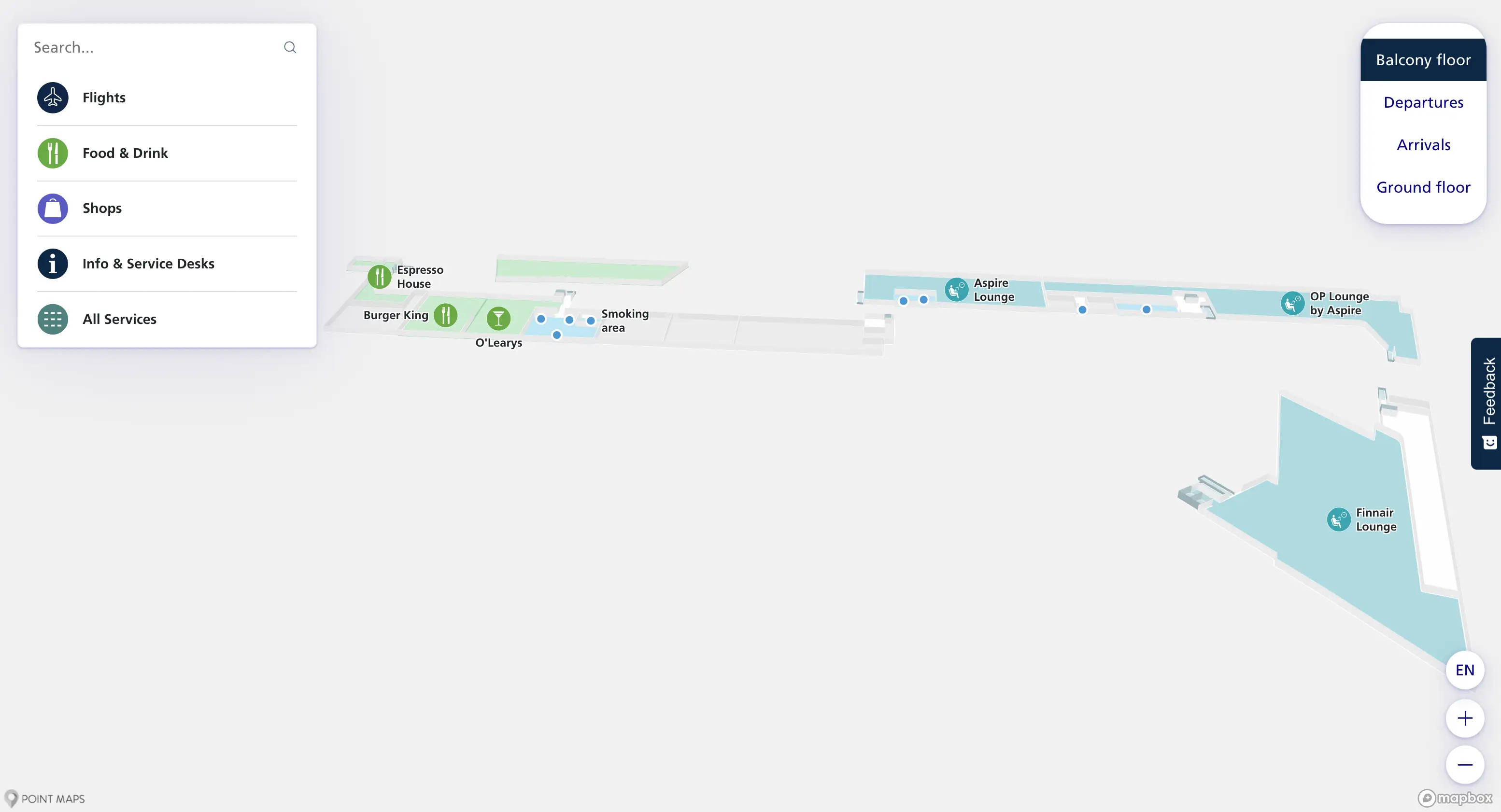
Helsinki Airport Balcony Floor Map 2025
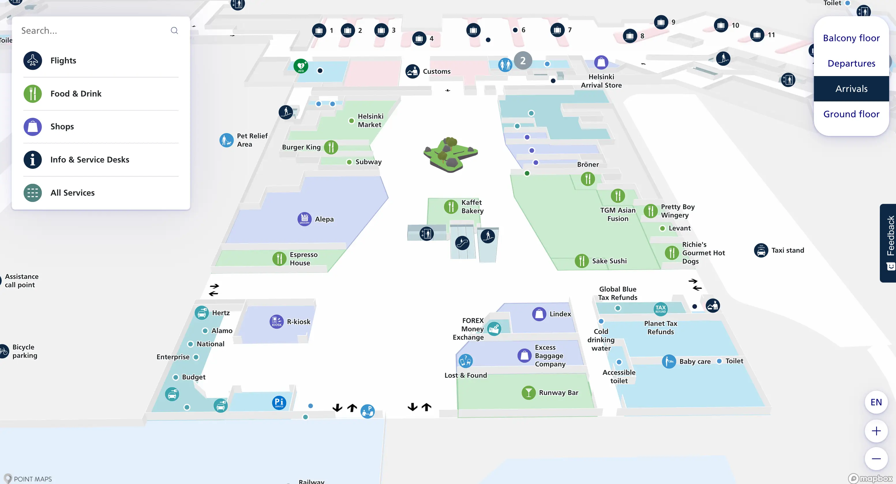
Helsinki Airport Arrivals Map 2025
2026 Helsinki Airport Map Guide
What is the exact walking distance (meters) from the main Security exit to the first “secondary screening / bag pulled aside” resolution area (the place you must go when your bag is flagged)?
The walking distance is under 2 meters because the flagged-bag resolution point sits immediately adjacent to the main security output belt on the same lane set. At Helsinki Airport, trays that clear exit onto the primary roller, while trays flagged by automated detection divert to a parallel belt beside it. The “go to” action is not a walk into a separate room; it’s a lateral step to the inspection position at the end of the conveyor, right before the glass partition into the airside retail corridor. The time risk comes from waiting for an officer to open and clear the bag, not from distance.
Where exactly is the Schengen → non-Schengen border control checkpoint located on the airside map, and what is the walking distance from the main Security exit to that checkpoint?
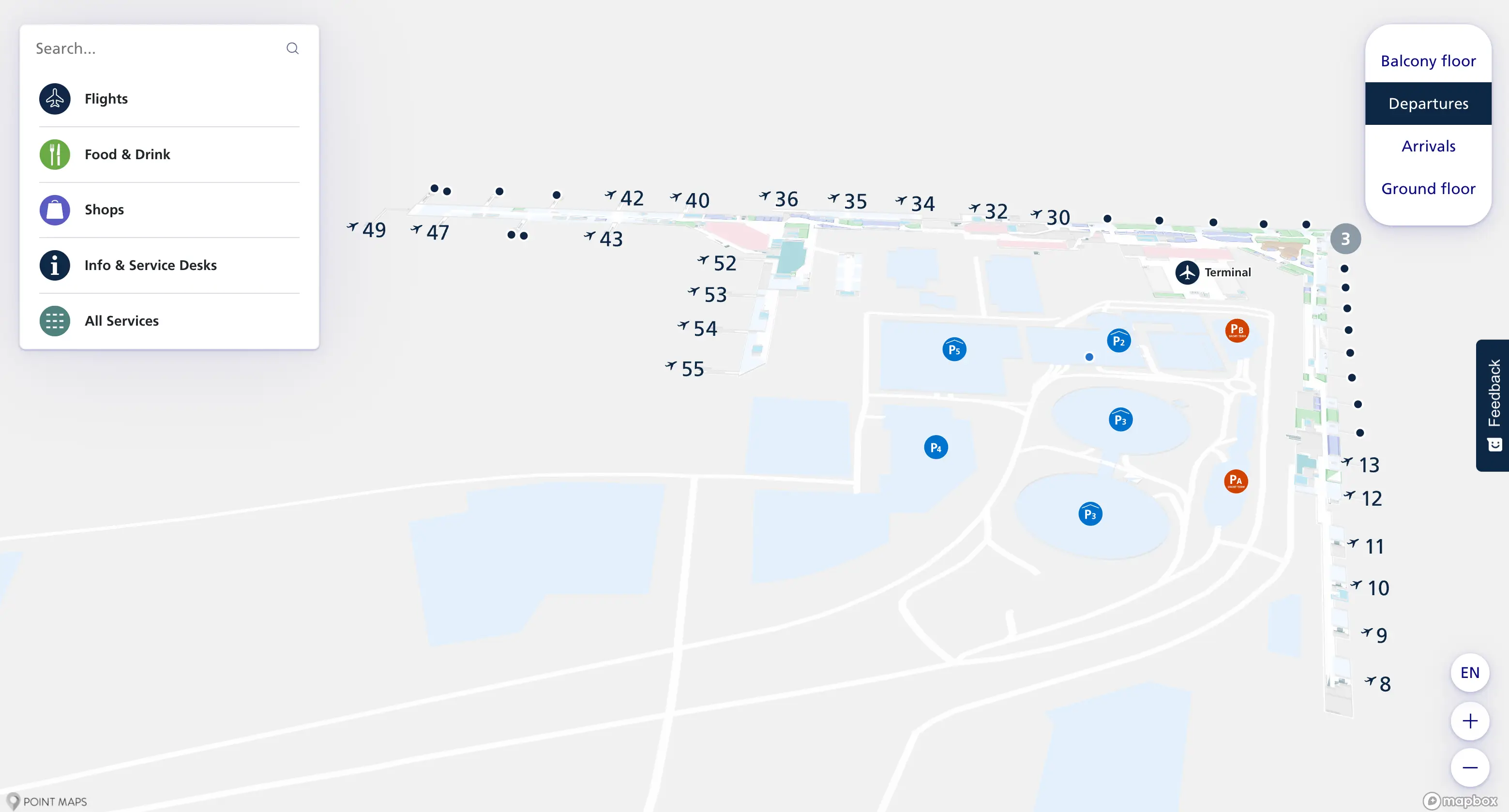
The Schengen-to-non-Schengen border control checkpoint is positioned at the terminal “hinge” between Gate 36 and Gate 37. From the main Security exit, the shortest route runs forward into the duty-free corridor, continues through the Aukio central plaza, then follows the signed stream for “Gates 37–55 / Passport Control” as the concourse curves toward the non-Schengen pier. The walking distance from the security exit to the passport control queue entrance is approximately 300–350 meters, with the key landmark anchor being Aukio as the last open retail node before the border-interface queue.
From border control, what is the exact walking distance to the furthest non-Schengen gate cluster (worst-case “far pier” scenario)?
The walking distance is approximately 450–500 meters from the exit of passport control to the furthest non-Schengen gate cluster at the deep end of the pier near Gate 55. After you clear the border-interface doors, the route becomes a straight, linear concourse with lounges on both sides and moving walkways along the centerline. The most reliable landmark anchor is the passport control exit threshold as the start point and the Gate 55 signage cluster at the pier tip as the endpoint, because mid-pier lounge names vary while gate-number progression is consistent.
Where is the bus arrival drop-off node for remote stands on the HEL terminal map, and what is the shortest route from that node to the Transfers corridor?
The bus arrival drop-off node sits airside on the ground level beneath the main gate piers, with the most common Schengen-side injection near the Gates 20–29 complex and a non-Schengen-side injection near Gates 50–52. From the Schengen bus node, the shortest route to the Transfers corridor is to exit the bus lobby, take the nearest escalator/elevator up to Level 2, then follow the main concourse flow past Gate 26 toward Aukio and the signed “Gates 37–55 / Passport Control” hinge. From the non-Schengen bus node near 50–52, the quickest path typically feeds into the non-Schengen flow where transfer screening can appear before you rejoin the mixed departures corridor.
Where is the bus-gate boarding area located (airside), and what is the walking distance from the central concourse to that boarding point?
The bus-gate boarding area is on the ground floor beneath the non-Schengen pier, concentrated under Gates 50–52 (often shown as bus gates with letter suffixes such as 50A–D). From the central Aukio concourse area (the main retail plaza at the start of the non-Schengen zone), the shortest route is to walk down the non-Schengen pier to the Gate 50 area on Level 2, then descend via the dedicated escalator/stairs to the ground-level bus lounge. The walking distance from Aukio to the Gate 50 bus lounge is roughly 400 meters, with the vertical descent acting as the commit point into the boarding “pen.”
What is the map-verified walking distance for the longest plausible gate-to-gate transfer inside HEL (identify the two gates/areas and the shortest route)?
The longest plausible gate-to-gate transfer is about 1,100 meters, running from Gate 5 in the far Schengen west wing to Gate 55 at the tip of the non-Schengen pier. The shortest route follows the main corridor from Gate 5 toward the central hinge, passes through the Aukio retail spine, reaches the passport control interface between Gates 36–37, then continues straight down the non-Schengen pier to Gate 55 using the moving walkways where available. The key anchors are Gate 5 signage in the older wing, Aukio as the central distribution plaza, and the passport control exit threshold as the point where the long-haul pier walk begins.
What is the exact walking distance for the commonly cited long transfer (e.g., Gate 5 to Gate 48 claim), using the airport map’s geometry rather than anecdote?
The walking distance is approximately 1,000 meters from Gate 5 to Gate 48 when routed via the Schengen–non-Schengen hinge and the shortest pier corridor. The route runs from Gate 5 along the west-wing corridor to the central retail spine, continues past Aukio to passport control between Gates 36–37, then proceeds partway down the non-Schengen pier to Gate 48 (mid-pier). Using the audit’s segment geometry, the Gate 5 → hinge portion is about 650 meters, and the hinge → Gate 48 portion is about 350 meters, which totals roughly 1 kilometer.
Where is the transfer security checkpoint (if applicable for certain origins) located on the map, and what is the walking distance from the inbound non-Schengen arrivals flow to that checkpoint?
The transfer security checkpoint is positioned at the non-Schengen arrivals convergence just before the border-interface area where flows rejoin the mixed departures corridors. For inbound non-Schengen passengers who require re-screening, the checkpoint functions as an airside filter between the arrival gates and access back toward the Schengen-side concourse. Distance depends on your arriving gate: it is about 50 meters from a close-in non-Schengen gate like Gate 38, and about 450 meters from the far end of the pier near Gate 55 because you must walk back up the non-schengen corridor to the convergence point before you can be screened. The most reliable anchor is the pier’s main corridor junction near the border-control zone rather than any single shop or lounge name.
Where is the decision split on the map where passengers accidentally drift toward Arrivals/Immigration instead of Transfers, and what signage/landmark anchors that split?
The highest-risk decision split is immediately after border control when you re-enter the Schengen side and the corridor bifurcates between staying on Level 2 for Transfers and turning right to descend to Level 1 for Baggage Claim/Exit. The anchor is the first big overhead yellow wayfinding board that prominently lists “Baggage Claim / Exit,” paired with the visible escalators dropping down to Arrivals. The correct Transfers path holds level (straight/left) toward Gates 1–36, while the wrong path commits you to the down-escalator, depositing you into baggage reclaim and forcing a full landside loop back up to Departures and Security.
If a traveler must go landside to re-check a bag, what is the shortest mapped route from Arrivals (baggage reclaim hall) to the nearest check-in/bag-drop zone, measured in walking distance?
The shortest mapped route is about 80 meters from the Arrivals baggage reclaim exit to the nearest check-in/bag-drop zone in the Departures Hall. From baggage reclaim, follow the flow through Customs into the public Arrivals Hall, then walk to the central escalator/elevator bank near the train-station access point and main public anchors, and go up to Level 2. At the top, the first check-in islands and bag-drop counters are immediately ahead and slightly fanned left/right across the hall. The walk breaks into roughly 50 meters from Customs exit to the escalators and about 30 meters from the escalator landing to the closest check-in desks.
From that bag-drop zone, what is the shortest mapped route back to Security re-entry, and what is the walking distance?
The shortest mapped route is a direct 20–50 meter walk from the nearest check-in/bag-drop island back to the main Security Control wall on the same departures level. From the bag-drop counters, turn toward the rear wall of the Departures Hall where the full-width security bank sits in clear line of sight, then walk straight across the open floor without needing any level changes. The most dependable anchor is the security wall itself (multiple parallel lanes spanning the back of the hall), because the exact check-in island varies by airline but the geometry stays consistent: check-in in the center of Level 2, security at the far side.