Hartsfield Jackson Atlanta International Airport Map (Most Up-To-Date)
ATL is a long, linear “fishbone” airport: two landside terminals (Domestic and International) bookend seven parallel concourses (T, A, B, C, D, E, F) linked by a single subterranean spine (Transportation Mall). Most navigation is a repeatable vertical pattern—down to Level 0, across, back up—inside Atlanta’s main airport hub complex, with Plane Train as the fast layer and tunnels/SkyTrain/shuttles as the contingency layers.
Map Table
| Terminal | Key Airlines | Primary Function | Transfer Mode |
|---|---|---|---|
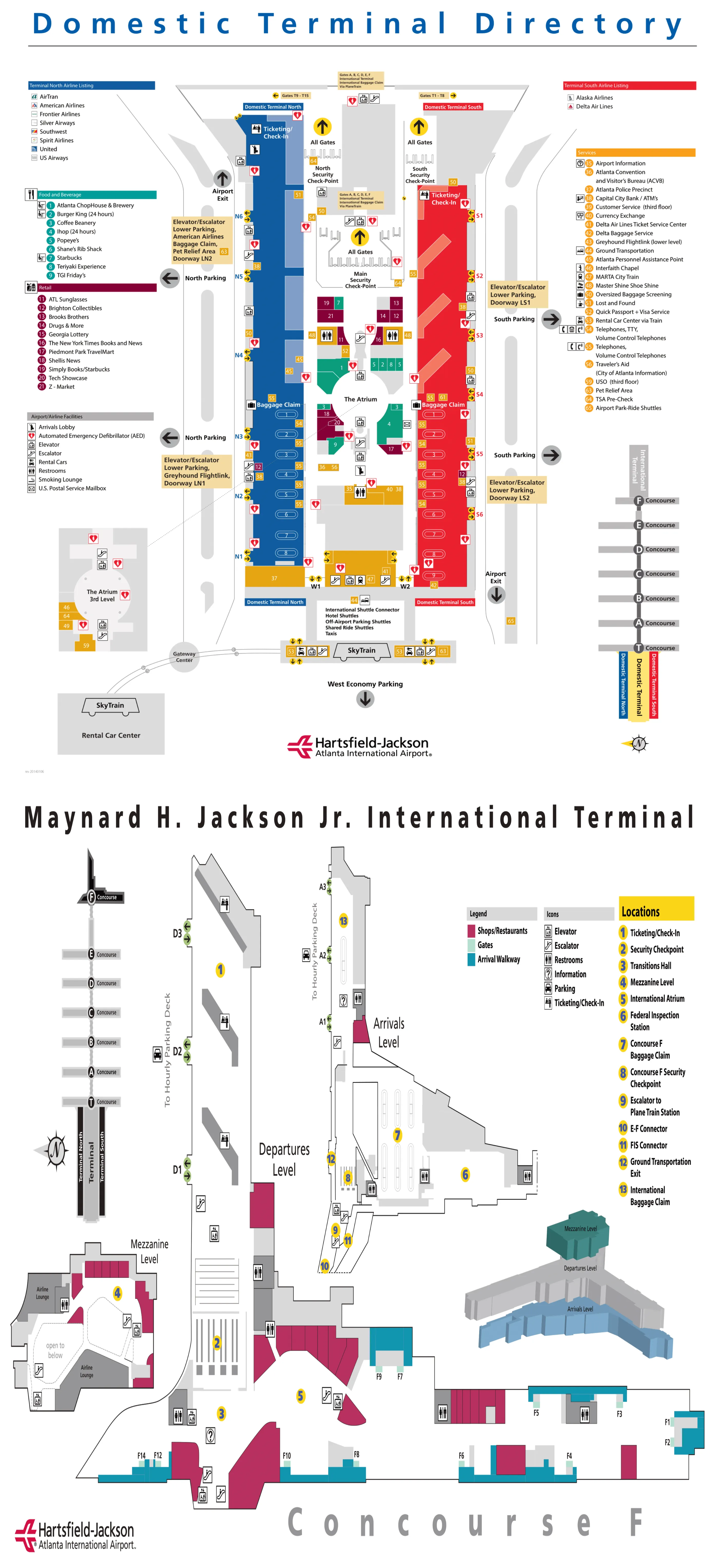
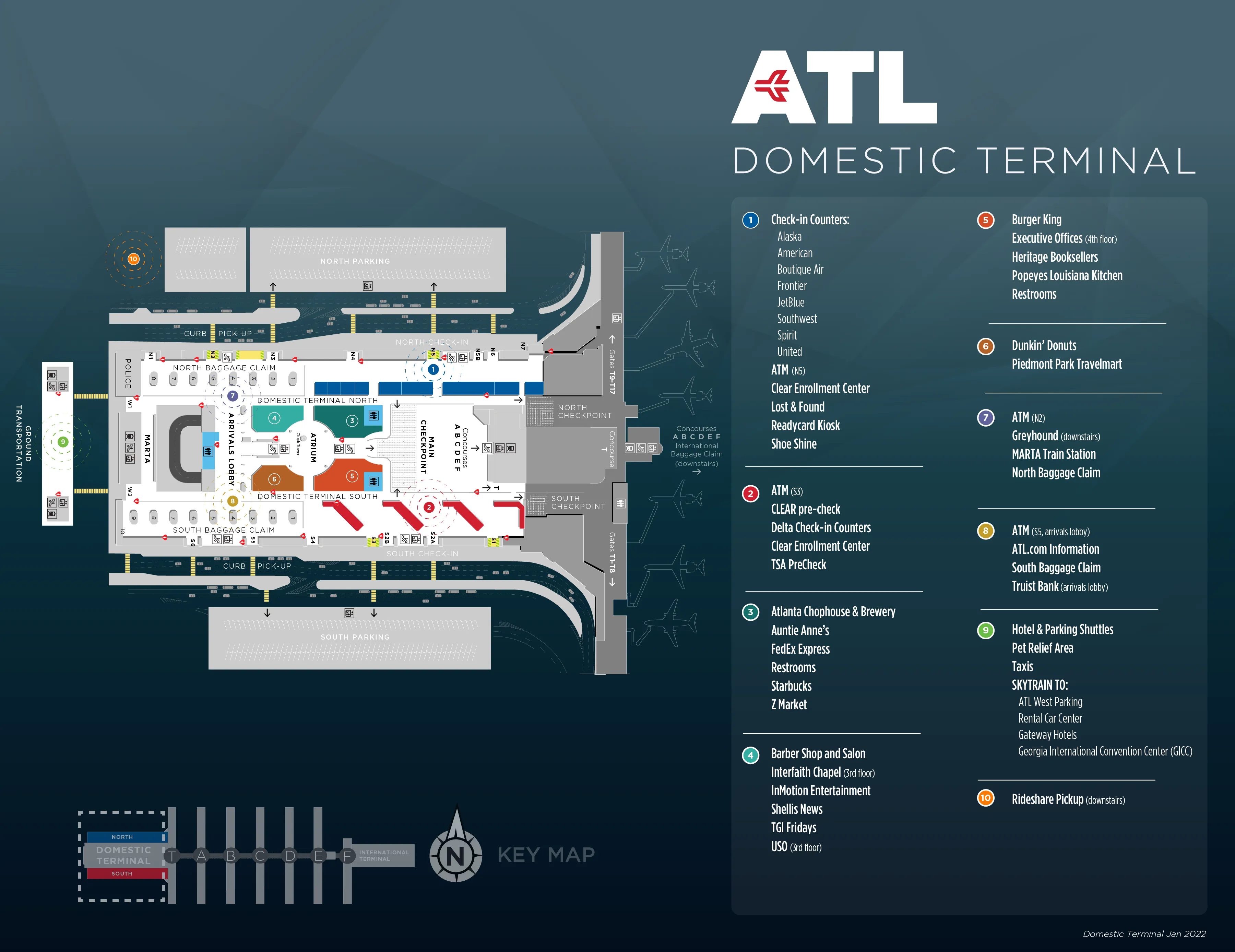
| Domestic Terminal South | Delta | ticketing, bag drop, baggage claim | Plane Train, Transportation Mall, SkyTrain |
| Domestic Terminal North | non-Delta carriers | ticketing, bag drop, baggage claim | Plane Train, Transportation Mall, SkyTrain |
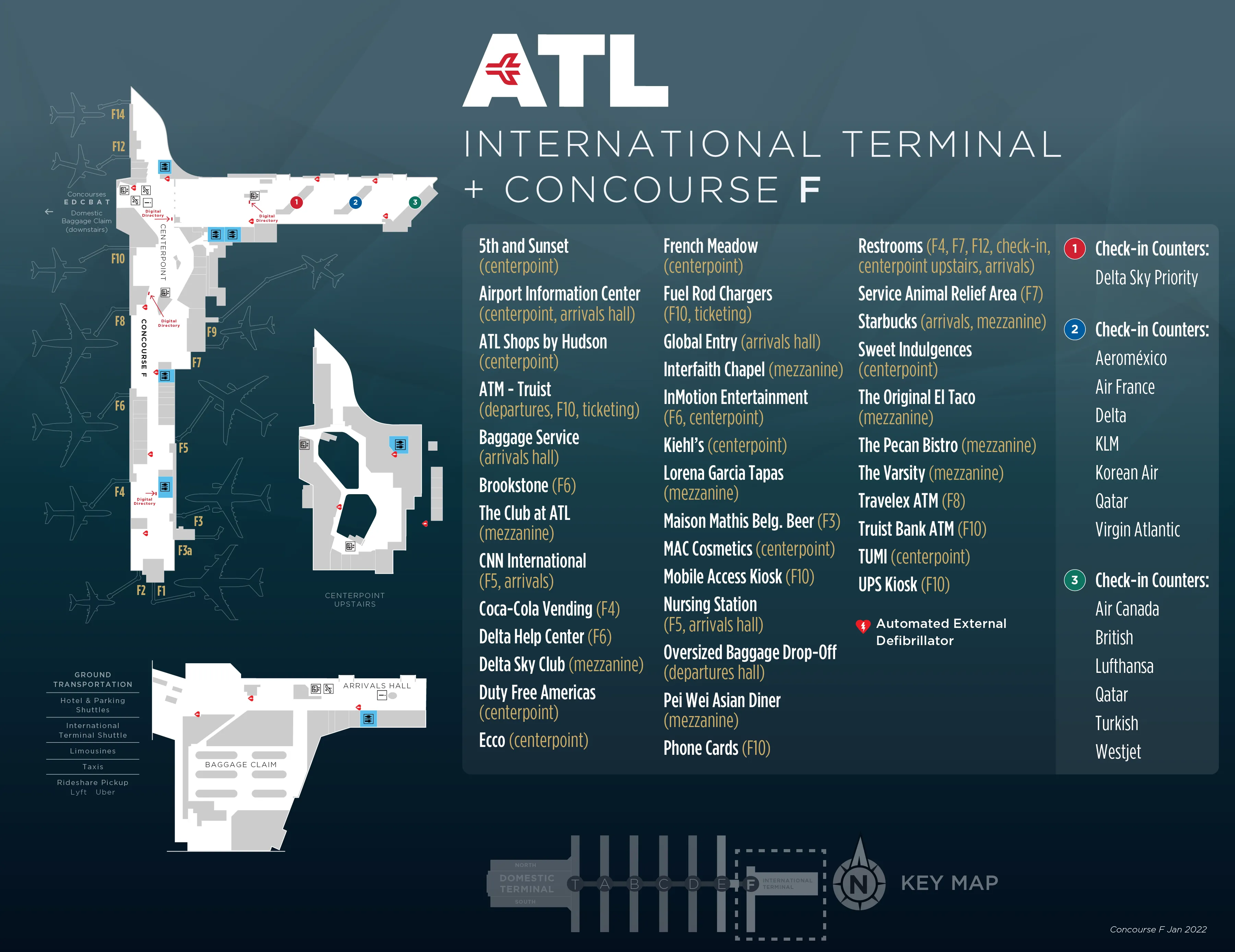
| International Terminal (F) | international arrivals flow | CBP, FIS, baggage recheck | Plane Train, shuttle bus |
Hartsfield Jackson Atlanta International Airport (ATL) Map Strategy
- Treat ATL as stacked layers, not one corridor: always identify your nearest “Center Core” down-point (escalator/elevator bank) before you commit to a direction.
- When Plane Train crowds or stalls, pivot immediately to the Transportation Mall walkway entrance between the escalator banks; don’t wait on the platform and lose the only low-friction fallback.
- After international arrivals, stop at the customs exit doors and choose the “Connecting Flights” path on purpose; a wrong turn to the public arrivals lobby forces a full landside recovery loop.
- Separate “Terminal” from “Concourse” mentally: the gate world starts only after security (Concourse T output), and ground-transport choices (rideshare/SkyTrain/shuttles) require level changes and garage/curb zone discipline.
2026 Hartsfield Jackson Atlanta International Airport Map + Printable PDF
In 2026, ATL still runs on the same decisive layers: Plane Train in the Transportation Mall, the parallel walk-tunnel fallback, and SkyTrain to the Rental Car Center/Gateway Center. The biggest “map truth” remains operational: rideshare pickup is consolidated away from the curbs (North Economy), and the International Arrivals connection fork after customs is still an irreversible decision point.
Hartsfield-Jackson Atlanta International Airport Domestic Terminal Map 2025
Hartsfield-Jackson Atlanta International Airport International Terminal Map 2025
2026 Hartsfield Jackson Atlanta International Airport Terminal Map Guide
What is the exact signed route from any Concourse centerpoint to the Plane Train platform entrance (level + landmark) when the train is operating?
The signed route is the Concourse Center Core to “Plane Train / Transportation Mall” signage, then down two escalator runs to the Plane Train platform on Level 0. From the concourse’s central atrium, follow the large overhead black/yellow wayfinding signs toward the Center Core, anchored by the main food court / seating hub at that concourse’s midpoint.
Use the same vertical pattern in every concourse: walk to the Center Core (center atrium), pass the escalator/elevator bank, and descend to the Transportation Mall. The first escalator drops to a landing/mezzanine, then a second escalator drops to the platform level. At Concourses A–D, you must choose direction before the final descent (Domestic/Baggage Claim vs International/Concourse F), because the platforms split around the pedestrian tunnel; at T, E, and F, you descend to a shared platform and choose boarding side by direction.
Where is the tunnel-walk entrance from Concourse B to the next concourse (exact escalator/elevator bank + nearest gate/landmark) when Plane Train is down?
The tunnel-walk entrance is in Concourse B’s Center Core between the escalator and elevator banks, adjacent to the central food court zone near the Gate B18/Delta Sky Club vicinity. From the B centerpoint, do not commit down the Plane Train escalators; instead, stay in the Center Core and look for “Transportation Mall” / “Walkway to Concourse C” overhead signs.
The doorway reads as a darker corridor opening compared with the brighter train-platform escalator well. The correct alignment is “center atrium → between the vertical conveyance banks → into the pedestrian tunnel,” using the food court intersection as your triangulation point. If the platform area is packed, turn your back to the train entrance and re-center on the escalator/elevator cluster; the walk-tunnel access is positioned as the parallel option at the same core node, not out on a gate spur.
What is the exact walking distance (feet/meters) from Concourse E Plane Train platform to Concourse E gate spine midpoint (map-measured)?
Walking measures about 350–400 feet (107–122 meters) from the Concourse E Plane Train platform to the midpoint of the Concourse E gate spine. The distance includes the full vertical transition from Plane Train level up to the concourse level, plus the horizontal walk from the Center Core into the central gate corridor.
The map-measured breakdown is roughly: a ~40-foot (12-meter) vertical rise from Level 0 (platform) to Level 2 (concourse), then about ~300 feet (91 meters) from the Center Core to the gate spine midpoint. The practical cue is that “Center Core” is the hinge: once you reach the top of the station escalators/elevators at E, you’re still not at gates until you push forward into the long straight gate corridor that branches away from the atrium seating/amenities node.
Where is the “International → Connecting Flights” decision split after passport control (the exact corridor/signage fork on the F arrivals map)?
The decision split is immediately outside the customs exit doors in the F International Arrivals corridor, within about 10 feet of the opaque sliding glass doors that dump you into the arrivals hall. The fork is a right-turn channel signed “Connecting Flights” / “Flight Connections” versus a left/straight flow signed “Exit,” “Ground Transportation,” or “Arrivals.”
The right turn keeps you on the tight corridor that leads straight to the baggage recheck belt and the TSA re-entry checkpoint, both visible in the same short hall. The left/straight path opens into the public arrivals lobby (families, concessions), and crossing that threshold is the irreversible mistake: you’ve gone landside and cannot backtrack to connections without leaving the building, taking the shuttle to Domestic, and re-clearing security.
What is the exact location of the baggage recheck drop belt after ATL international arrivals (relative to the customs exit doors)?
The baggage recheck drop belt is immediately after the right-turn “Connecting Flights” fork, positioned along the corridor wall about 50–100 feet (15–30 meters) from the customs exit doors. It sits as a staffed counter-and-belt line on the wall-side of the connections hallway.
After you pass through customs and step out the sliding glass doors into the International Arrivals Hall, turn right at the first signed split for “Connecting Flights.” The recheck belt appears almost right away—before you have time to drift into the public lobby—anchored by airline/contract staff checking bag tags. If you can already see the TSA re-entry checkpoint lanes ahead, you’re in the correct corridor and the belt should be on your side along that same short run.
What is the exact walking distance from international arrivals recheck to the re-entry security checkpoint entrance (map-measured)?
Walking is less than 100 feet (under 30 meters) from the international arrivals baggage recheck belt to the re-entry TSA checkpoint entrance. The two points sit in the same short connections hallway, with the checkpoint visible from the bag drop area.
After you turn right at the post-customs “Connecting Flights” split, you drop checked bags at the wall-side recheck belt, then continue forward only a few dozen steps to the TSA queue mouth. The layout functions like a single processing room: customs exit doors behind you, recheck belt along the corridor, and the re-entry security lanes directly ahead—so if you find yourself walking long enough to question it, you’ve likely drifted toward the public arrivals lobby instead of staying in the tight connections corridor.
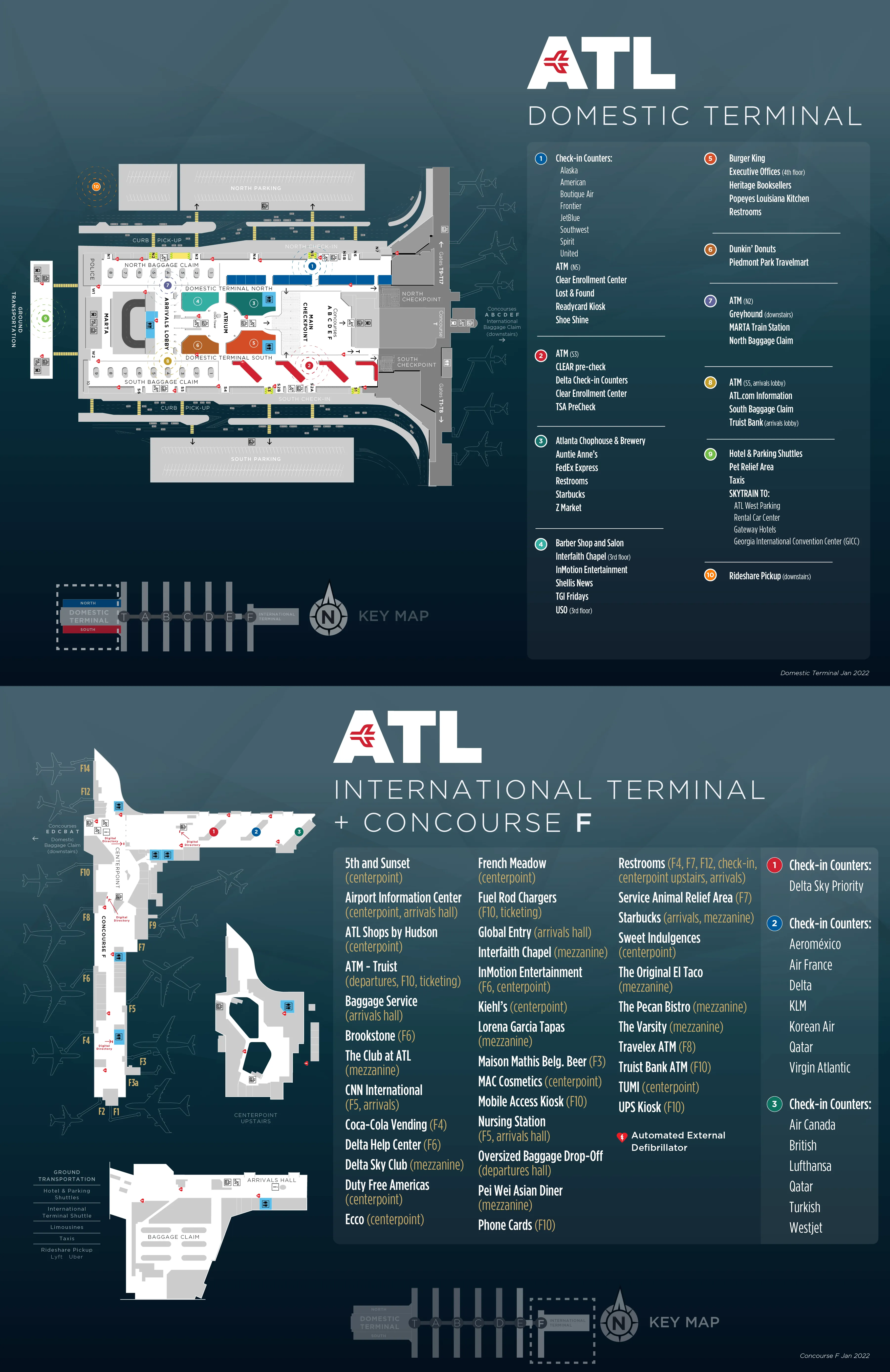
Which specific checkpoint entrance (North or South) is closest on-foot to the Plane Train access point (map distance from curb to train)?
The South checkpoint entrance is closest on-foot to the Plane Train access point, because its post-security exit aligns straight into the central escalator bank down to the Transportation Mall. The North checkpoint requires a lateral cross-Atrium adjustment after screening before you can line up with the down escalators to the train.
Map-distance runs about 300–400 feet (91–122 meters) from the South curbside area to the Plane Train intake, versus roughly 400–500 feet (122–152 meters) from the North curb due to the off-axis walk. If your goal is “curb → security → Plane Train” with minimal decision friction, South (and Main) keeps you on the cleanest forward axis toward the escalators; North adds a sideways traverse across the checkpoint output zone before you can descend.
Where is the TSA PreCheck queue start point on the departures level for the South side (exact door/zone/landmark)?
The TSA PreCheck queue on the South departures level starts at the South Security Checkpoint entrance, with the PreCheck/Digital ID lanes on the far right when you’re facing the checkpoint. The landmark is the checkpoint frontage itself: you’re looking for the dedicated lane set that peels off to the right edge of the screening entry.
Use the South side’s Delta-dominant layout to triangulate: from South ticketing, walk toward the South Security Checkpoint frontage (the screening “mouth” off the South side of the Atrium). As you square up to the checkpoint, do not join the central general line; shift fully to the rightmost lane grouping, where PreCheck branding and Digital ID pylons appear. In morning banks, the queue can snake back into the South ticketing lobby, but it still originates from that far-right checkpoint edge.
Where is the TSA PreCheck queue start point on the departures level for the North side (exact door/zone/landmark)?
The TSA PreCheck queue on the North departures level starts at the North Security Checkpoint entrance, typically on the left side of the checkpoint frontage when you’re facing security. The landmark is the North checkpoint “mouth” on the non-Delta side of the Domestic Terminal, where the PreCheck lane set sits left-of-center relative to the main queue.
From North ticketing, walk toward the North Security Checkpoint signage and stop when you reach the point where the lines split into lane groups. The PreCheck entry is the left-side channel at that frontage, rather than the central general queue. Operationally, North PreCheck is more volatile than South (it may close earlier in the evening), so if you arrive and the PreCheck lane is shuttered, the on-map recovery move is crossing through the Atrium to use Main or South screening instead of searching deeper in North.
What is the exact curb-to-check-in walking route for Delta on the South side (door number/nearest column marker if shown on maps)?
The Delta curb-to-check-in route is South Departures (Upper Level) → enter Door S1 (or LS1) → continue to the Red Zone Sky Priority/Premium check-in at the far right end of the South ticketing hall, closest to the Atrium. The key landmark is the Sky Priority branding cluster and Digital ID pylons in that Red Zone.
After curb drop-off on Terminal South Departures, aim for Door S1/LS1 as your clean entry point into Delta’s primary lobby segment. Once inside, keep moving toward the right-hand end of the hall (toward the Atrium connection) rather than drifting left into the broader counter banks. If you’re navigating by “zones,” Red Zone is your anchor for premium/Sky Priority processing; standard Delta check-in counters radiate from the same South hall, but the Red Zone cluster is the most distinct wayfinding beacon from the S1/LS1 entry.
Where is the rideshare pickup entrance path from South baggage claim (exact baggage claim number → escalator down → garage crossing start)?
The rideshare pickup path from South baggage claim starts in the South claim hall (Carousels 1–10), then routes west through the Atrium into the North claim area, down near Doors N2/N3, and out Door LN1 to begin the North Economy garage crossing. The “exact” baggage claim anchor is that you must begin from any South carousel in the 1–10 block, not the South curb.
From South baggage claim, do not exit to the South curb (that’s taxis/limos). Walk west toward the Atrium/Plane Train arrival escalators, continue across into the North baggage claim hall, and keep going to the west end. Look for the escalator/elevator bank between Doors N2 and N3 and descend to the lower level, then exit via Door LN1. The garage crossing starts immediately outside LN1, where the marked rideshare path leads across the crosswalk into the North Economy pickup area.
Where is the rideshare pickup entrance path from North baggage claim (exact baggage claim number → escalator down → garage crossing start)?
The rideshare pickup entrance from North baggage claim runs from the North claim hall to the west end, down by the Doors N2/N3 escalator/elevator bank, then out Door LN1 to start the North Economy garage crossing. The key fixed anchors are the west-end descent point (N2/N3 area) and the lower-level exit at LN1.
From whichever North carousel you retrieve bags at, walk toward the west end of the baggage claim hall (away from the Atrium side). At the west end, locate the escalators/elevators positioned between Doors N2 and N3 and go down to the lower level. Exit through Door LN1, then immediately follow the marked rideshare route across the crosswalk into the North Economy lot pickup zone, where Uber/Lyft staging is consolidated.
What is the exact “meet arriving passenger” pickup curb location for international arrivals (F terminal) on the arrivals roadway (door/zone/level)?
The “meet arriving passenger” pickup curb for International Terminal F is on the Arrivals Level (Lower Level) at the outer curb outside Doors A1, A2, and A3. The usable anchor is the traffic-island/outer curb lane on the arrivals roadway directly in front of those A-door sets.
Do not default to Departures level for pickups at F. Drive to the International Terminal Arrivals roadway, stay oriented to the A-door numbering on the lower level, and use the outer curb at A1–A3 as the pickup zone where most meet-and-greet behavior concentrates. This is also the same general curb environment where app-based pickups may appear at International (unlike Domestic, where rideshare is pushed to North Economy), so the “outer curb + A1/A2/A3” triangulation keeps you from circling the wrong level.
Where is the SkyTrain entrance from Domestic Terminal baggage claim (exact corridor past MARTA + exterior door/landmark)?
The SkyTrain entrance is at the extreme west end of the Domestic Terminal, reached by walking the corridor past the MARTA station entrance, then exiting the building through Door W1 (North) or Door W2 (South) to the covered walkway leading to the SkyTrain station. The landmark is the MARTA breeze entry area with “RCC / SkyTrain” signage.
From Domestic baggage claim, orient yourself toward the west end (away from the central Atrium) and follow signs for MARTA/Rental Car Center. As you pass the MARTA station access, continue into the same west-end corridor until you reach the exterior exit doors labeled W1/W2. Step outside, stay under the canopy, and follow the obvious station structure straight ahead; the station building is separated from the terminal by a short outdoor walk, which is the cue you’re on the correct SkyTrain path rather than the Plane Train (which stays fully underground and airside-connected).
What is the exact walking route from SkyTrain drop-off to the Rental Car Center counters (platform exit → corridor → counter hall entry)?
The route is SkyTrain arrival at the Rental Car Center on Level 4 → exit the platform through the station gates/portal → descend the central escalator bank to Level 3 → enter the Customer Service Hall where the rental counters line the atrium. The counters are not on the platform level; the escalator drop puts you directly into the counter hall.
After stepping off the SkyTrain at the RCC stop (after Gateway Center), follow the main flow off the platform toward the central vertical core. Take the prominent escalators down one level to Level 3; you should land in a large open atrium with agency signage (Hertz, Avis, etc.) along the perimeter—this is the Customer Service Hall entry point. If you find yourself on a level with only track/platform features and no counters, you haven’t taken the Level 4 → Level 3 descent yet.
Where is the shuttle pickup point that links Domestic Terminal to the International Terminal (exact curb zone/door/level)?
The shuttle pickup that links Domestic and International terminals is on the International Terminal Arrivals Level (Lower Level) curb outside Doors A1 and A2, and on the Domestic Terminal West Curb outside the west-end door zone (W1/W2 area). The defining attribute is that this shuttle runs landside on the perimeter road, not through the secure concourse spine.
At International Terminal F, go to the lower/Arrivals roadway and use the curb directly outside A1/A2, where shuttle loading concentrates. At the Domestic Terminal, orient to the extreme west end (by the MARTA/SkyTrain corridor) and use the West Curb pickup area adjacent to Doors W1/W2 rather than the central Atrium frontage. Because this is an outside-the-sterile-area transfer, plan for security re-screening when you arrive at the other terminal.
Where is the map-visible boundary that explains “Terminals don’t have gates” (the point where ‘Terminal South/North’ transitions into Concourse T access)?
The boundary is the security checkpoint output: the moment you exit TSA screening and step past the glass partition into the airside corridor, you are in Concourse T rather than “Terminal South/North.” That checkpoint exit node is the map-visible transition where landside processing space ends and gate space begins.
On the landside side of that line are ticketing, baggage claim, and the Domestic Terminal Atrium labeled North/South. On the airside side are gates labeled T1–T21, with T1–T8 to the south/right of the checkpoint exit and T9–T21 to the north/left. This is the practical fix for the phantom-zone error: if your boarding pass says a T-gate, taking the Plane Train immediately after security is the wrong move because you’re already in the only concourse physically attached to the Domestic Terminal structure.
What is the exact Plane Train stop-to-concourse vertical path at Concourse F (platform → escalator bank → concourse entry landmark)?
The Concourse F vertical path is platform (Level 0) → long escalator bank up to a mezzanine → brief mezzanine traverse past the Customs/Immigration overlook and Delta Sky Club area → short connector escalator to the Concourse Level (Level 2) at the F atrium. The anchor landmark at the concourse entry is the large chandelier art installation in the F atrium.
After you exit the Plane Train at F, you do not pop straight into gates the way older concourses feel. Take the long, high-capacity escalators up from the platform to the mezzanine, follow the main flow across the mezzanine (you’ll pass the overlook-facing circulation and the Sky Club-adjacent zone), then take the shorter escalator segment that delivers you into the main F concourse atrium. If you can see the chandelier feature, you’ve re-entered the correct gate-level node.
Where is the closest restroom cluster to the Plane Train platform at Concourse D (map-verified, nearest landmark/gate)?
The closest restroom cluster is at the Concourse D centerpoint on the concourse level (Level 2), immediately where you emerge from the Plane Train station escalators into the D Center Core near the central food court intersection. The restroom location is anchored to the D atrium’s main amenities node rather than out on a gate spur.
Exit the Plane Train at Concourse D and ride the escalators up to the concourse level; once you step off into the center atrium area, you’re at the D Center Core. The restrooms are in that immediate centerpoint cluster, adjacent to the food court/cross-traffic junction where passengers split toward the D gate spine. If you start walking down the long gate corridor away from the atrium, you’ve already passed the nearest restroom option.
Where is the nearest elevator (not escalator) from Plane Train level to Concourse A gate level (exact location on the map)?
The nearest elevator is in Concourse A’s Center Core, positioned between the up and down escalator banks that connect the Plane Train station (Level 0) to the concourse/gate level (Level 2). It sits in the same vertical conveyance cluster as the escalators but is partially obscured by the structural columns around the escalator machinery.
From the Plane Train at Concourse A, follow the main flow toward the station’s vertical exit point, but instead of joining the escalators, look at the center of the escalator pair where the elevator doors and blue ADA signage mark the accessible route. The practical triangulation is “Center Core → escalator bank → elevator between escalators,” not along a gate corridor. If you reach the concourse atrium without seeing the elevator, you likely took the escalators; the elevator is meant to be found before you commit upward movement, right in that central core node.
Archive Hartsfield-Jackson Atlanta International Airport Terminal Map
Below are all historical map versions for Hartsfield-Jackson Atlanta International Airport. Each year includes the official map available for that period, presented as both WebP and PDF.
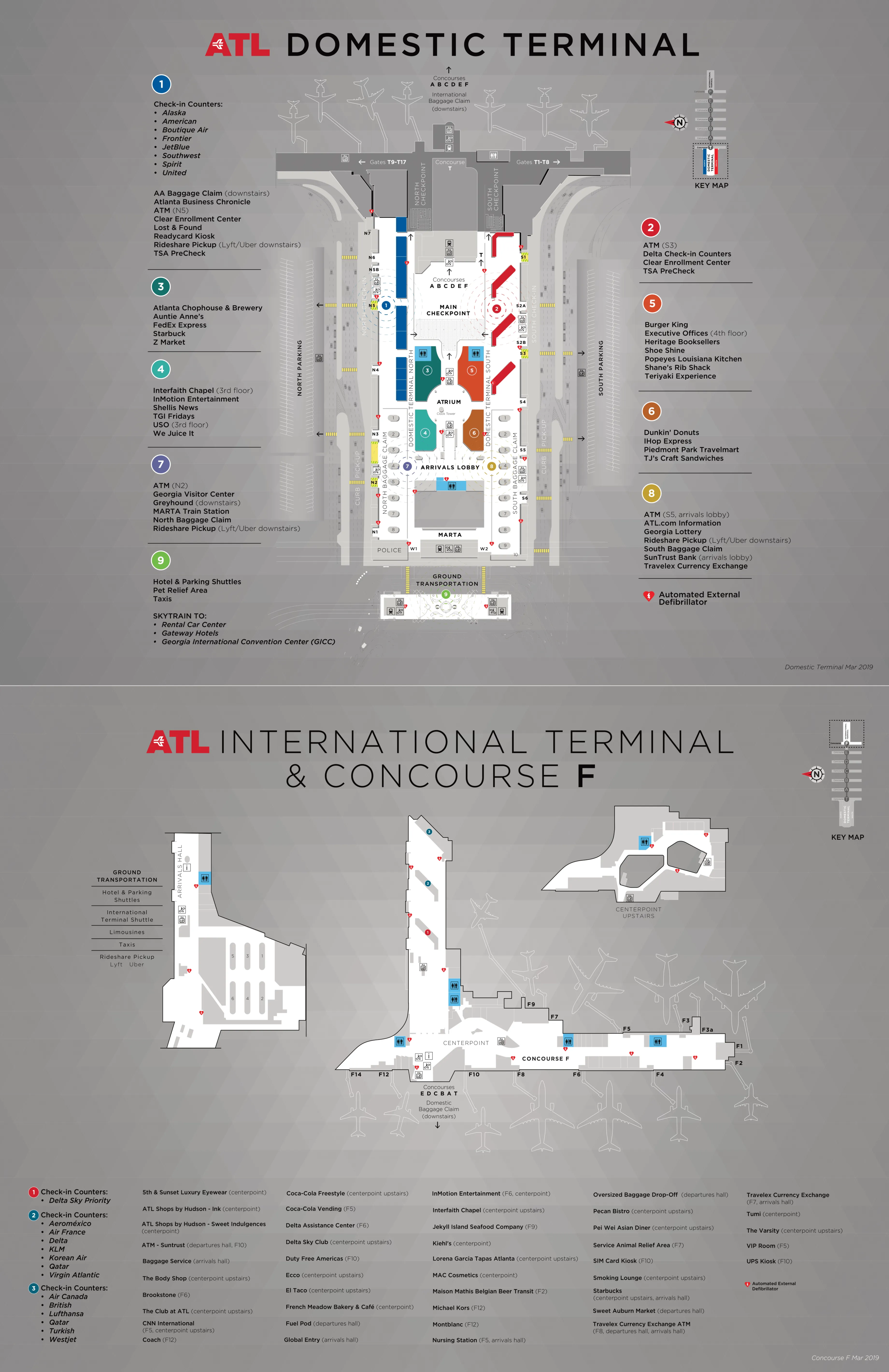
2019 Hartsfield-Jackson Atlanta International Airport Terminal Map
2013 Hartsfield-Jackson Atlanta International Airport Terminal Map