Halifax Stanfield International Airport Map (Most Up-To-Date)
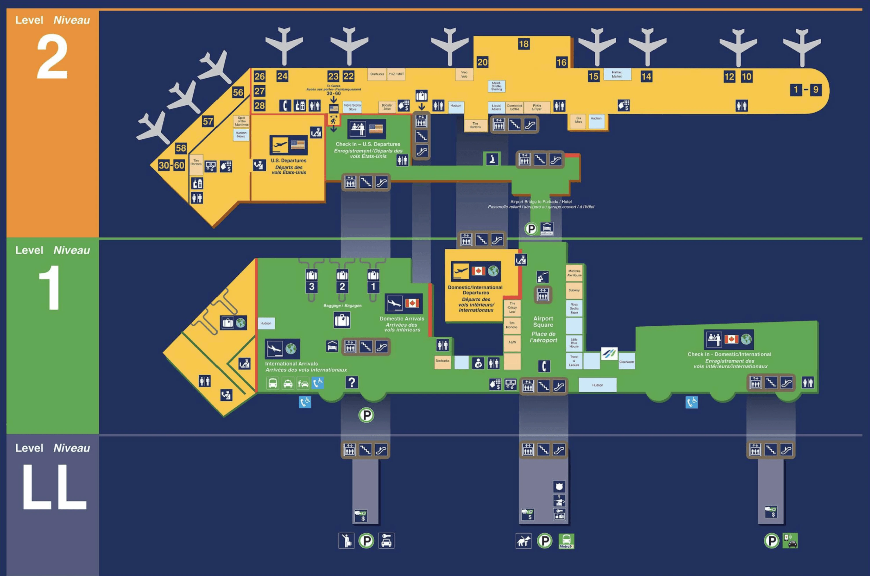
Halifax Stanfield International Airport (YHZ) runs as a compact, single-terminal block with a clear vertical split: Domestic/International processing on the main level and a separated U.S. transborder zone upstairs. Most passenger movement funnels through one central security checkpoint and one central Arrivals hall, so queues can backfill into public circulation fast. Within Nova Scotia’s main airport grounds, the “Centre Court” atrium and central elevators act as the primary orientation spine for both departures and arrivals.
Map Table
| Terminal | Key Airlines | Primary Function | Transfer Mode |
|---|---|---|---|
| Single terminal | Air Canada, WestJet, United, American | Domestic, International, U.S. preclearance | Walk-only, vertical via central elevators/escalators |
Halifax Stanfield International Airport Map Strategy
- Treat central security like a “spill zone” system: when the queue blows past the checkpoint stanchions, it backs through the atrium toward the Centre Court central elevators, and the real line start may be behind that elevator bank—not at the front-facing ropes.
- Use Verified Traveller as a time-gated entrance, not a permanent lane: the entry is on the far-left side of the central security array when it’s operating as a dedicated lane; outside those windows, the only usable “start point” is the manual merge at the head of the main queue.
- For U.S. departures, plan around the Level 2 shutter: the first meaningful 5:00am lineup forms at the closed preclearance screening doors beside U.S. check-in, and you cannot “flow around” it because the mezzanine has no buffer corridor.
- Anchor curbside moves to Door 3 and the central ground-transport node: Park’N Fly payment happens by the Visitor Information Centre, then the shortest exit is the central doors to the shuttle zone; MetroX/Airport Express 320 boarding requires the outer-island crosswalk move after you’ve handled tickets at the ground-transport booth.
2026 Halifax Stanfield International Airport Map + Printable PDF
Current operations still concentrate pressure into a few fixed nodes: the central security lanes (with time-gated Verified Traveller behavior), the Level 2 U.S. preclearance doors (fixed opening hours), and the Arrivals ground-transport frontage (ticket booth + outer-island stops). For 2026 travel planning, the practical map is the one that marks where lines physically spill and where curbside pickup points actually sit—by door and island.
2026 Halifax Stanfield International Airport Map Guide
What is the exact physical start point of the Verified Traveller / NEXUS access at YHZ security (the doorway/merge point where you leave the main queue)?
The Verified Traveller / NEXUS start point at YHZ is the far-left entrance position of the Central Security Checkpoint array (when you’re facing the screening lanes), where a dedicated stanchioned entry is signed for NEXUS/Verified Traveller during its active windows. When that dedicated lane is not running, the start point becomes the manual merge at the head of the main queue, where a CATSA officer pulls eligible travelers forward into the next available lane.
A dedicated entry stanchion is typically set on the left edge of the checkpoint frontage beside the main queue maze, using the Centre Court atrium as your landmark—stand facing security with the central elevators behind you, then look to the left-most lane opening. Outside the dedicated-lane hours, you do not leave the main queue from the middle; you walk to the front and present eligibility at the officer-controlled merge point at the checkpoint mouth.
Where does the security line physically spill into when it backs up “past the elevators” (which corridor/landmark does the queue wrap around)?
The overflow security queue at YHZ spills backward out of the stanchion maze into the main Level 1 atrium and extends along the circulation path parallel to the check-in counters, wrapping past the Centre Court central elevator bank.
When the ropes fill, the “real line” stops being at the checkpoint mouth and starts behind the elevator doors that connect Arrivals, Departures, and the Level 2 U.S. check-in mezzanine. The queue typically runs straight back from central security, then bends around the elevator area and begins to pinch the Centre Court alcove, where the nursing room and nearby washrooms sit. At that point, cross-terminal movement gets forced into narrow gaps as people trying to reach the elevator/escalator up to Level 2 end up cutting across a static line.
What is the walking time (minutes) from the U.S. check-in area to the U.S. preclearance entrance at YHZ (normal pace, no stops)?
Walking takes under 2 minutes from the U.S. check-in counters to the U.S. preclearance entrance at YHZ at a normal pace with no stops.
The route stays entirely on Level 2 in the transborder mezzanine: from the far end of the U.S. check-in counter line, walk along the same short frontage toward the preclearance screening intake immediately beside the counters. The distance is roughly 50–80 meters, so there’s effectively no “buffer hallway” to absorb crowds—if a queue forms at the preclearance doors, it can back up into the check-in area almost immediately.
When U.S. preclearance opens at 5:00am, what is the exact choke point location where passengers form the first meaningful queue (before the booths, at a staircase, at a corridor pinch, etc.)?
The first meaningful 5:00am U.S. preclearance queue at YHZ forms directly at the closed security shutter/entrance doors to the U.S. preclearance screening area on Level 2, immediately adjacent to the U.S. check-in counters.
Passengers accumulate there during the 03:30–05:00 window after bag drop because there’s no alternative routing into the transborder screening zone while CBP is closed. The crowd compresses into a dense pack right at the door line, and when the shutters open at 05:00, throughput is immediately throttled by the small number of active screening lanes (often only one or two). With the mezzanine’s limited floor space, there isn’t a corridor pinch or stair landing that “meters” the line first—the door face itself is the choke point.
Where is the Park’N Fly payment kiosk located (which wall/door/landmark in Arrivals), and what is the shortest path from that kiosk to the correct shuttle pickup curb?
The Park’N Fly payment kiosk is in the public Arrivals hall on the ground level, positioned immediately beside the Visitors Information Centre/ground transportation hub area, aligned with the central exit doors (Door 3).
From baggage claim, exit into the Arrivals lobby and walk to the Visitors Information Centre area in the middle of the hall; the pay station sits right there, and the intercom button at the kiosk is part of the “summon” step. After paying, take the shortest path by exiting straight out the adjacent central doors (Door 3) to the commercial/shuttle curb directly in front of that central block, then wait at the signed Park’N Fly pickup zone on the curb lane (not the outer island bus shelter).
For Park’N Fly (or similar shuttle lots), what is the exact signed pickup spot at the terminal (door number / pillar range / curb zone) where the shuttle consistently stops?
The Park’N Fly shuttle pickup is at the central Arrivals curb outside Door 3, in the signed shuttle/commercial loading zone directly in front of the Visitors Information Centre area.
Door 3 is the practical anchor because the pay kiosk and the “summon” intercom are located by the Visitors Information Centre in the middle of the Arrivals hall, and the shortest exit from that node is the central doors. Once outside, stay on the curb lane serving shuttles and commercial vehicles and look for the Park’N Fly pickup signage in that central segment. This is not the outer-island MetroX bus stop area and not the southern rideshare zone—if you walk to those, you’ll miss the consistent Park’N Fly curb position and end up backtracking.
At the terminal, where is the Airport Express 320 bus stop located relative to Arrivals doors (which door/bay/sidewalk segment), using the current stop location (not outdated info)?
The Airport Express (MetroX) 320 stop at YHZ is on the outer curb island across the inner traffic lanes, positioned toward the south end of the terminal frontage and reached from the central Arrivals area around Door 3 or the slightly south exit at Door 4.
Inside the terminal, the Ground Transportation Booth in the center of Arrivals is the best triangulation point; from that node, you exit via the central/south doors and then use the marked crosswalk to reach the separate outer island where the bus shelter and stop signage sit. The stop is not against the terminal wall curb where private pickups happen—it’s on the detached island used for commercial/transit loading, near the south-side ground transport zones.
What is the walking distance from baggage claim exit to the Airport Express 320 stop, including the exact crossing points (crosswalks/medians) you must use?
Walking distance is about 50–60 meters (165–200 feet) from the baggage claim exit into Arrivals to the Airport Express 320 stop at YHZ using the direct central path and outer-island crossing.
From the baggage claim doors, walk to the central Ground Transportation Booth in the Arrivals hall (about 20 meters), then continue to the nearest central/south exit doors (Door 3 is the cleanest anchor; Door 4 also works) for roughly another 15 meters. Outside, use the painted pedestrian crosswalk straight across the active inner curb lanes to the outer commercial island (about 15 meters), then turn along the island edge to the signed bus stop/shelter. Skipping the booth first often causes a double-back because tickets are handled inside at the central node.
Where is the best pickup staging point for drivers (short-wait lot / meter area / loop position), and what is the fastest route from there to the Arrivals curb without getting trapped in the loop?
The best pickup staging point at YHZ is the Standby Lot (cell phone lot) at 311 Bell Boulevard beside the Tim Hortons drive-thru, which prevents the loop trap and keeps you off the terminal curb until the passenger is actually ready.
Wait there until the traveler confirms they’re outside with bags, then exit the shared driveway and make a right turn onto Bell Boulevard to head straight back toward the terminal approach. Continue to the terminal loop and choose the correct frontage zone based on where the passenger is standing: the first curb block serves the Domestic/International Arrivals area, and the downstream block serves the U.S. transborder frontage. Using the loop to “circle” instead of staging is the failure mode—once you miss the curb window, you’re forced to recirculate the Silver Dart Drive loop and lose minutes in traffic control and merging.
Where is the rental car pickup path from Arrivals—specifically, what is the correct first decision point (turn/door/escalator) that prevents wayfinding failure?
The correct first decision point for rental cars at YHZ is the “Centre Tunnel” choice in the Arrivals rotunda: you turn from the Arrivals hall toward the signed tunnel access instead of exiting to the curb.
After you enter the public Arrivals lobby with bags, look for rental car/parkade signage that directs you to the Centre Tunnel on the same level. Taking that tunnel keeps you indoors and grade-separated under the roadway, delivering you to the Airport Parkade access where you can reach the rental car center on the lower level (P1) via the parkade elevators/escalators. The common failure is doing the intuitive move—going out Door 3/4 to the curb and trying to cross into the garage from outside—because it adds weather exposure, extra crosswalk decisions, and a higher chance of entering the wrong parkade level and backtracking.
For first-time arrivals, what is the exact route from Gate exit to the correct baggage carousel (including the level change location and the point where the carousels first become visible)?
The route to baggage claim from swing-gate arrivals at YHZ runs through a glassed-in sterile corridor to a forced level descent that deposits you directly into CBSA primary inspection, with the baggage carousels becoming visible only after you clear that inspection zone.
After deplaning at gates in the swing set (notably the 22–24 and 26–28 area), you’re directed into a separated glass corridor that parallels the domestic departures lounge rather than entering the main concourse. Follow that corridor to the vertical circulation core and descend from Level 2 down to Level 1, where the path feeds straight into the CBSA primary inspection hall. After kiosks/officer processing, you continue forward into the international baggage claim hall; the first clear sightline to the carousel area typically opens after the inspection exit as the corridor widens into the baggage room.
For delayed international baggage retrieval, what is the exact handoff location where staff emerge with the escorted bag (which customs exit door / adjacent landmark), so the traveler waits in the right spot?
The delayed international baggage handoff at YHZ is typically done at the public-side baggage service/delayed bag office accessed through the unmarked wooden doors to the right of the international check-in desk area, rather than inside the secured baggage hall.
The practical waiting landmark is the international check-in bank on Level 1: stand facing the international counters, then move to the right-side service-corridor doors (described as unbranded/unmarked wood doors) instead of drifting left toward the U.S. customs/elevator path. That right-hand door zone functions as the recovery interface when you’re told to return later, because you cannot re-enter the secure carousel room to meet staff. Waiting at the main Arrivals doors or at the carousel exits wastes time and usually results in being redirected back across the hall to the hidden side-door location.
Archive Halifax Stanfield International Airport Map
Below are all historical map versions for Halifax Stanfield International Airport. Each year includes the official map available for that period, presented as both WebP and PDF.
2022-2026 Halifax Stanfield International Airport Map (Official 2022 Edition)


