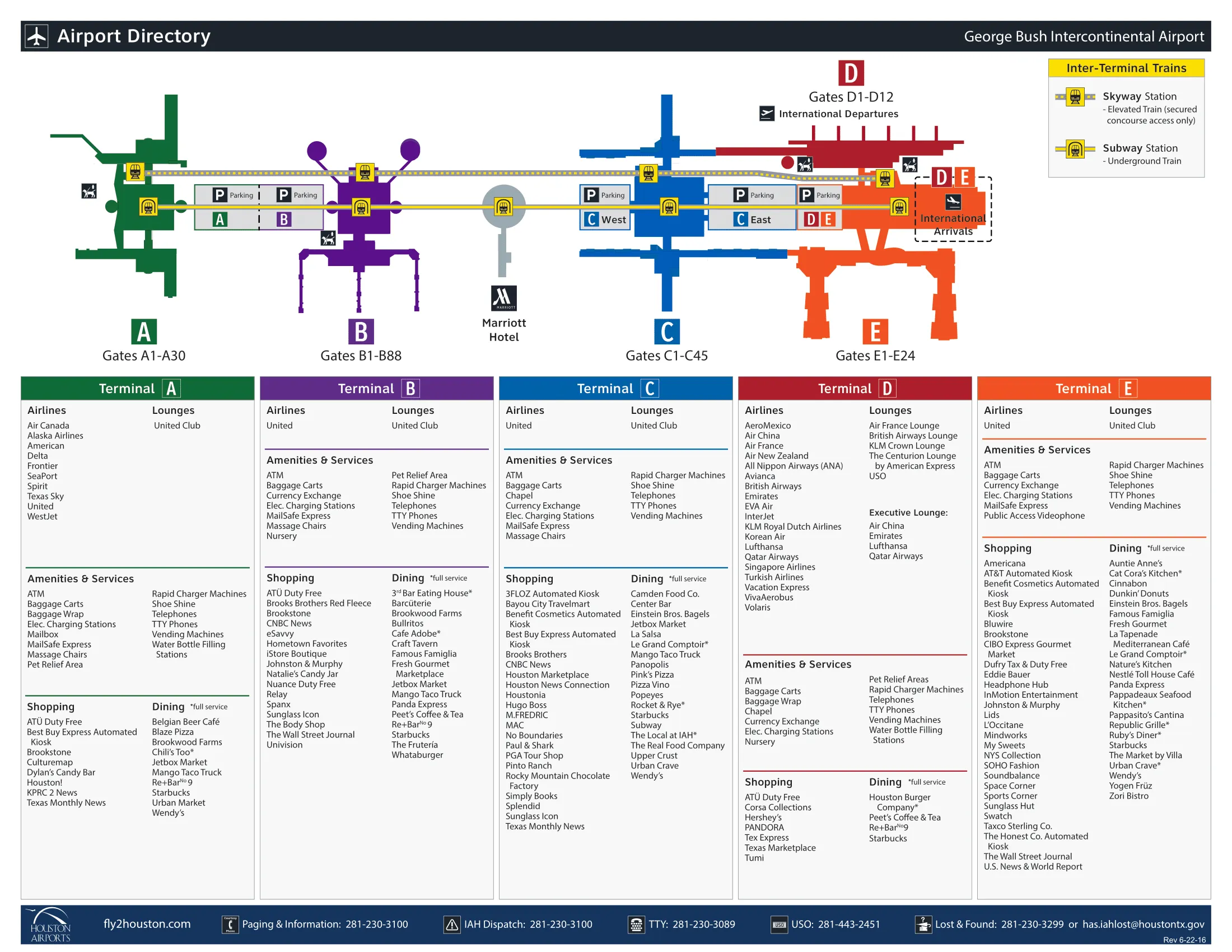
George Bush Intercontinental Airport Map (2025-2024)
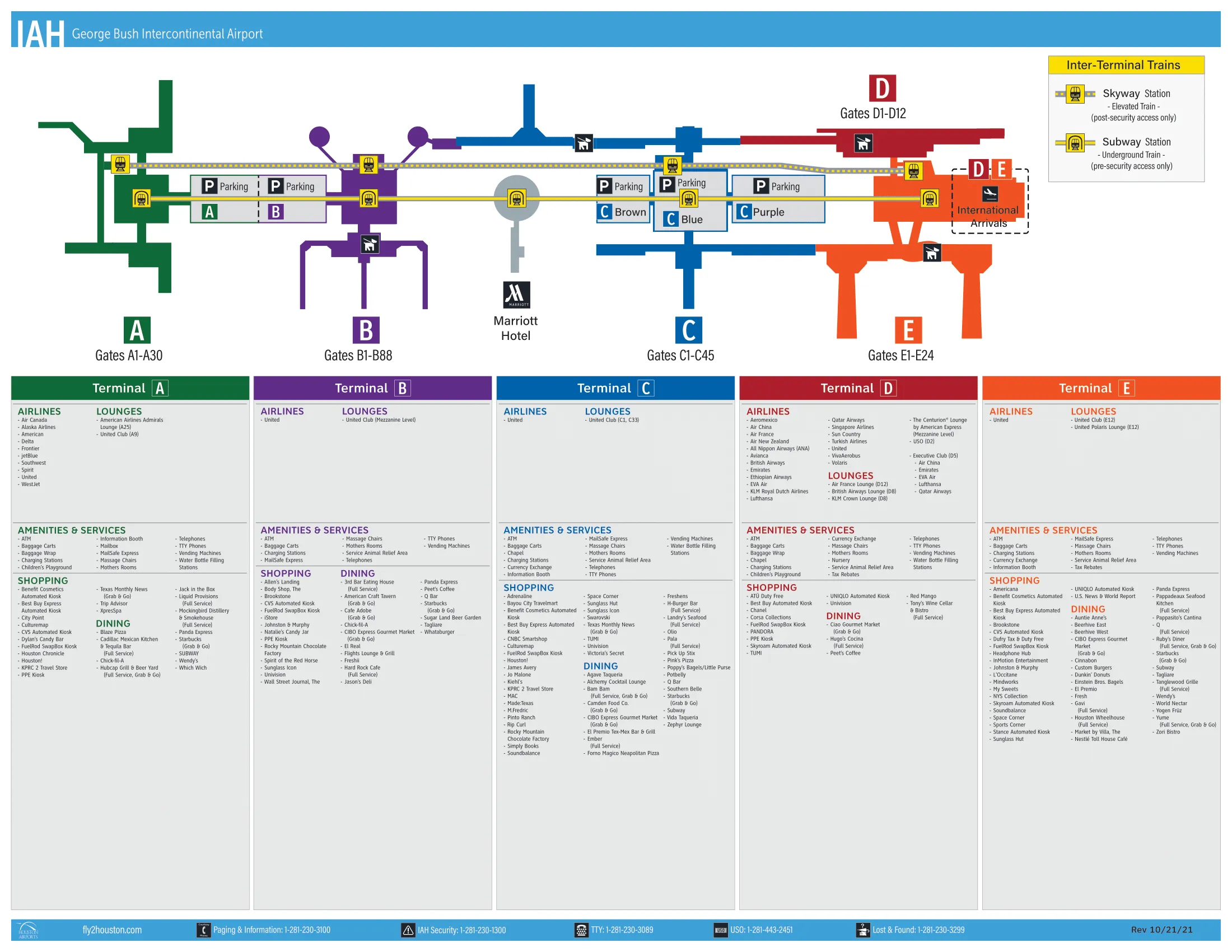
George Bush Intercontinental is a five-terminal loop (A–E) with a United-heavy core on the east side (B/C/E) and a satellite feel on A. Airside connectivity is strong because Skyway links every terminal, while landside movement is more fractured due to construction and curb changes across Houston’s primary airport complex. Orient first to your “start terminal” (check-in/TSA), then commit to Skyway or Subway.
Map Table
| Terminal | Key Airlines | Primary Function | Transfer Mode |
|---|---|---|---|
| Terminal A | American, Delta, Spirit, Frontier | Domestic, non-United | Skyway (airside), Subway (landside) |
| Terminal B | United Express | Regional gates, landside disruption | Skyway (airside) |
| Terminal C | United | Primary domestic hub, main processor | Skyway (airside), Subway (landside) |
| Terminal D | Mixed international | International concourse interface | Skyway (airside), Subway (landside) |
| Terminal E | United + international arrivals | International ticketing, FIS/Customs | Skyway (airside), Subway (landside) |
George Bush Intercontinental Airport Map Strategy
- Start-terminal rule: if Terminal B landside access is disrupted, begin at Terminal C for check-in/TSA, then go up to Level 3 for Skyway to Terminal B gates.
- Skyway vs Subway rule: Skyway is airside and fast for terminal-to-terminal gates; Subway is landside only and requires exiting security to use it.
- Commit early at Terminal C: after TSA you must change levels to reach Skyway (TSA exit level vs Skyway level mismatch), or you’ll drift into concourses and backtrack.
- Pickup friction rule: avoid “wrong side” curbs during peak congestion; for Terminal C rideshare and shuttles, default to the South-side door cluster (not the North-side doors).
2026 George Bush Intercontinental Airport Map + Printable PDF
Phased construction still changes where you should begin landside, even when the airside map looks “normal.” Terminal B’s landside processing remains a common failure point, while Terminal E’s ticketing/check-in status can shift by phase and airline. Treat Skyway as the default connector, and use Subway only for pre-security terminal changes.
2026 George Bush Intercontinental Airport Map Guide
What is the exact walking distance (in feet/meters) from Terminal C’s main TSA exit to the Skyway station entrance?
No direct level access exists from Terminal C’s TSA exit to the Skyway platform because Skyway is on Level 3 while the main TSA exit deposits you on Level 2. Walking from the TSA exit recomposure area to the central elevator/escalator core for Skyway is about 150–250 feet (about 45–75 meters).
The Skyway entry path starts immediately in the “Town Square” atrium just past the TSA exit lanes, aiming for the central vertical-transport bank rather than either C concourse. Use the first visible elevator/escalator core in the atrium (before you drift toward gates C1–C15 or the far C-North side) and go up one level to reach the Skyway station entrance on Level 3.
Which Skyway station is the closest mapped access point for reaching Terminal B gates after clearing security in Terminal C?
The Terminal C Skyway Station is the closest mapped access point for reaching Terminal B gates after you clear security in Terminal C. Terminal B’s landside lobby closure makes Skyway the practical entry to B gates, with Terminal C acting as the primary processor for check-in and TSA.
From the Terminal C “Town Square” post-security atrium, go to the central elevator/escalator core to Level 3 and enter the Skyway at the Terminal C station. Ride Skyway directly to the Terminal B Skyway Station, which drops you airside for the B gates without any need to exit and re-clear TSA.
Where is the exact check-in / bag-drop location shown on airport maps for Terminal E departures during periods when the E lobby/check-in is closed?
Terminal C’s United ticketing lobby is the mapped fallback check-in and bag-drop start point for Terminal E departures when the Terminal E lobby is closed. Terminal B cannot serve as a substitute landside processor, so the reliable “start terminal” becomes Terminal C.
Enter on Terminal C Departures and use the United check-in/bag-drop counters in the main ticketing hall (the landside processor directly above the Terminal C baggage-claim level). After bag drop and TSA at Terminal C, go back to the central post-security “Town Square” atrium and take the elevator/escalator core up to Level 3 for Skyway, then ride to Terminal E for gates.
What is the mapped walking distance from the Terminal E/D airside connector to the Terminal C domestic baggage claim entrance (the shortest shown route)?
Sterile segregation is the dealbreaker: international arrivals into Terminal E cannot use the airside connector to reach Terminal C domestic baggage claim until after Customs and TSA re-screening. The shortest “shown” airside route only applies to domestic-side movement, not international sterile routing.
For domestic-side movement, the shortest mapped walk between Terminal E/D and Terminal C uses the same primary C–D/E connector corridor anchored near Gate C45, at roughly 0.65 miles (about 3,400 feet / ~1,035 meters) end-to-end between terminal centers. To reach Terminal C baggage claim, you then drop landside via Terminal C’s central core to Level 1 and enter at the main baggage-claim doors closest to the center of the terminal.
What is the exact mapped location (zone/door area) of rideshare pickup for Terminal C, relative to the baggage claim exits?
Terminal C rideshare pickup is on the Terminal C South Side door cluster, not the North Side doors. The mapped pickup doors are C-103, C-104, and C-105, which sit along the south curb line relative to the baggage-claim exits.
From Terminal C baggage claim, orient to the central core and exit toward the South Side curb rather than the North Side (avoid Doors C-101/C-102). If you emerge at the wrong curb, re-enter through the nearest baggage-claim door and cross through the interior to the South Side exits so your app geofence matches the rideshare zone at Doors C-103 through C-105.
Where is the Subway (landside train) station entrance located on maps for Terminal A/B parking, and what is the shortest mapped path to it from the garages?
The Subway station entrance for Terminal A/B parking is on the basement/Level LL tunnel level between the A/B garage and the terminal core, not in the main terminal lobby. The shortest mapped path runs from the garage elevator bank down to the subterranean connector tunnel that feeds directly into the Subway station.
From the A/B parking garage, take the nearest interior elevator down to the lowest marked level (often signed as LL/Basement for Subway/Terminal connections), follow the pedestrian tunnel signage toward “Subway,” and enter the station at the tunnel-node before you surface into Terminal A/B public areas. If you walk up into the terminal ticketing level first, you’ve gone past the shortest access and will need to backtrack down.
Which TSA checkpoint location (by terminal) is mapped as the shortest path to reach Terminal B gates when B check-in/security is unavailable?
Terminal C’s TSA checkpoint is the shortest mapped screening start point for reaching Terminal B gates when Terminal B check-in/security is unavailable. Terminal B’s landside lobby closure makes “screen at B” a dead-end for most passengers.
After curb drop-off at Terminal C Departures, use either the Terminal C North or Terminal C South checkpoint (both feed the same post-security “Town Square” atrium). From the TSA exit, go immediately to the central elevator/escalator core in the atrium, ride up to Level 3, and enter Skyway at the Terminal C station. Skyway drops you at the Terminal B station airside, aligned for the B gates without exiting security again.
What is the shortest mapped post-security walking route between Terminal C and Terminal E (i.e., which connector corridor is shown as primary)?
The primary post-security walking route between Terminal C and Terminal E is the airside connector corridor anchored near Gate C45 in the C-North concourse. This corridor is the mapped pedestrian link signed for “Terminal D/E,” and it functions as the main walkable alternative to Skyway.
From Terminal C’s central post-security “Town Square,” follow the C-North direction toward the high-number gates, continue until you reach the far end near Gate C45, then enter the D/E connector walkway that leads into the Terminal D/E airside complex. The full C-to-E center-to-center walk is about 0.65 miles (around 3,400 feet / ~1,035 meters) and typically takes about 17 minutes, which is why Skyway remains the faster default.
Where is the Subway station entrance inside Terminal C (arrivals/landside), and which nearby landmark (door/escalator/core) anchors it?
The Terminal C Subway station entrance is on Level LL (Lower Level/basement) and is anchored by the Marriott Hotel connector elevator bank in the center core of Terminal C. The station is not on the curb perimeter, so you must go back inside the terminal to reach it.
From Terminal C arrivals/baggage claim (Level 1), walk toward the central core where signage points to the Marriott Hotel, then take the elevators marked for the Marriott/Subway down to Level LL. The reliable landmark is the Marriott Hotel connector access point rather than a numbered curb door; if you’re standing outside at Arrivals curb, you’re in the wrong place to find the Subway entrance.
Where is the exact mapped location of baggage recheck after international arrivals in Terminal E (post-customs) for connecting passengers?
The baggage recheck area is immediately to the right after you exit Customs in Terminal E’s international arrivals hall. Missing this right turn is a one-way failure because you cannot backtrack once you enter the public meeter/greeter lobby.
After CBP inspection and the Customs exit doors, turn right into the recheck zone where the connecting-passenger bag belts/counters sit along that right-hand wall. Use the Customs exit doors as your anchor point: straight ahead leads to the public arrivals lobby, while the right-hand corridor leads to baggage recheck for onward flights. If you walk straight out, the recovery route requires going up to Departures and re-queueing at ticket counters, adding major delay.
What is the mapped pickup point for the Rental Car Center shuttle from Terminal C, and what is the shortest walking path to it from baggage claim?
The Rental Car Center shuttle pickup for Terminal C is on the Terminal C South Side at Doors C-105 and C-106. This pickup sits in the same south-side curb zone that concentrates other ground-transport activity, so door accuracy matters.
From Terminal C baggage claim, walk to the central core and follow signs to the South Side exits, then leave the building at Door C-105 or C-106. Stay near the outer curb/bus lane where shuttles loop; if you wait at Terminal C North or at the wrong end of the South curb, buses can bypass you as they remain in the active outer lanes rather than stopping at every door.
Where is the Cell Phone / Waiting Lot shown on official airport maps relative to the terminal loop, and what is the mapped driving path from it to Terminal C arrivals?
The primary Cell Phone / Waiting Lot is off Will Clayton Parkway at 5703 Will Clayton Pkwy, outside the terminal loop on the main inbound corridor feeding Terminals C/D/E. The simplest mapped drive keeps you on Will Clayton inbound and avoids detours that force extra loops.
From the Will Clayton Parkway cell phone lot exit, turn onto Will Clayton heading toward the airport, then stay in the main inbound flow until you reach the terminal loop split signed for “Terminals C/D/E.” Follow Terminal C signage to Arrivals and stay committed to the C/D/E side of the loop rather than drifting toward A/B. If you get pulled toward Colonel Fisher Road “return to terminal” routing, you can end up re-merging awkwardly and missing the clean C/D/E split.
What is the exact mapped walking distance from Terminal A TSA exit to the Skyway station used to reach Terminal E (for the “screen in A, ride to E” strategy)?
Walking from Terminal A’s TSA exit to the Skyway escalator/station entrance is about 150 feet (about 45 meters), with a required vertical change from the TSA exit level to the Skyway level. Terminal A’s Skyway access is concentrated in the central core, so the shortest path depends on not drifting into the A-North or A-South gate wings.
After you clear TSA in Terminal A, stay in the central core and immediately take the first escalator/elevator up one level to the Skyway station area. From the Terminal A Skyway station, the ride to the D/E side is about 4 minutes 15 seconds, making this a viable “screen in A, ride to E” fallback when other processors are congested or disrupted.
Archive George Bush Intercontinental Airport Map
Below are all historical map versions for George Bush Intercontinental Airport. Each year includes the official map available for that period, presented as both WebP and PDF.
2022-2025 George Bush Intercontinental Airport Map (Official 2022 Edition)
2019 George Bush Intercontinental Airport Map
2016 George Bush Intercontinental Airport Map