Frederick Douglass Greater Rochester International Airport Map (Most Up-To-Date)
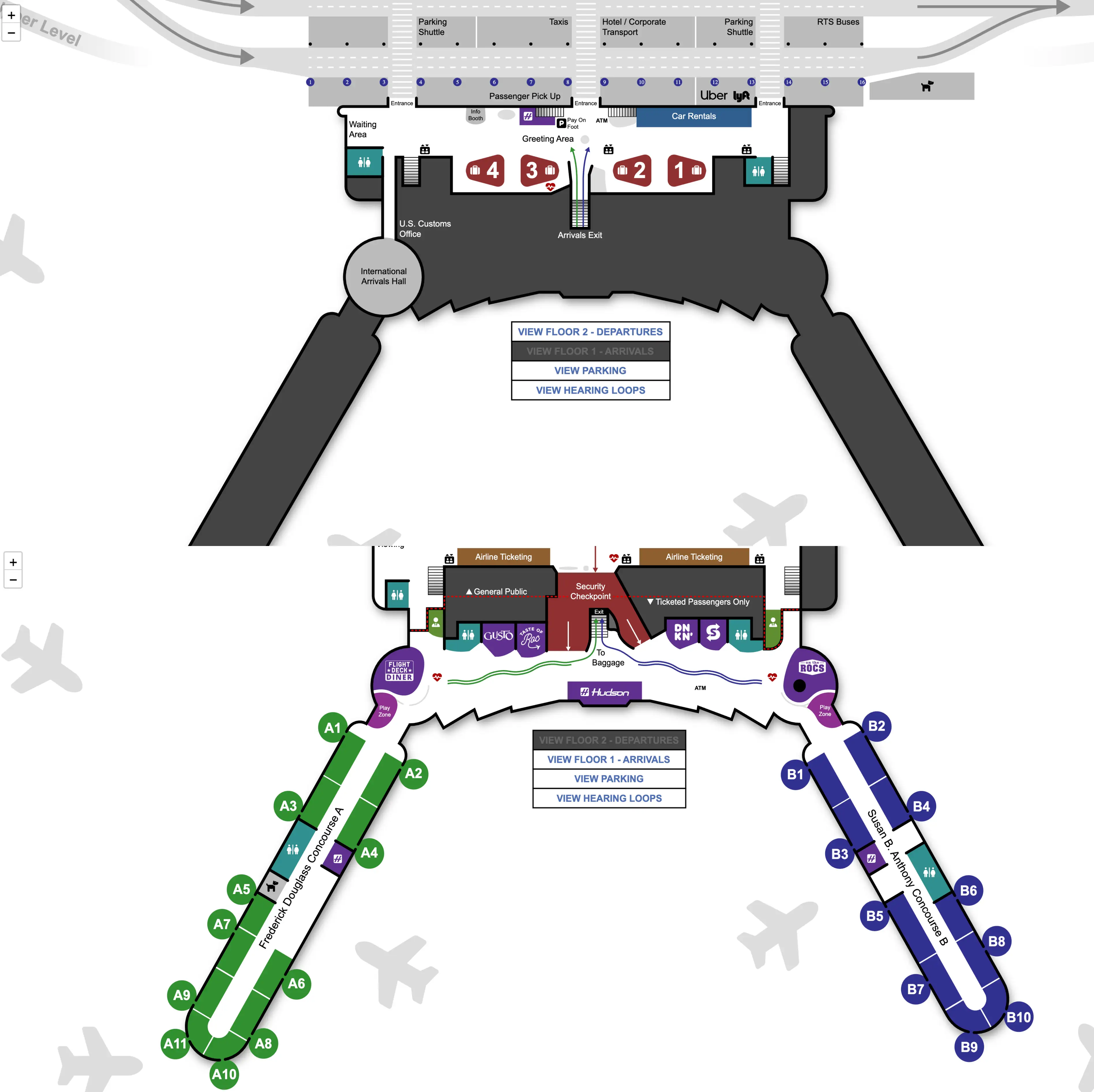
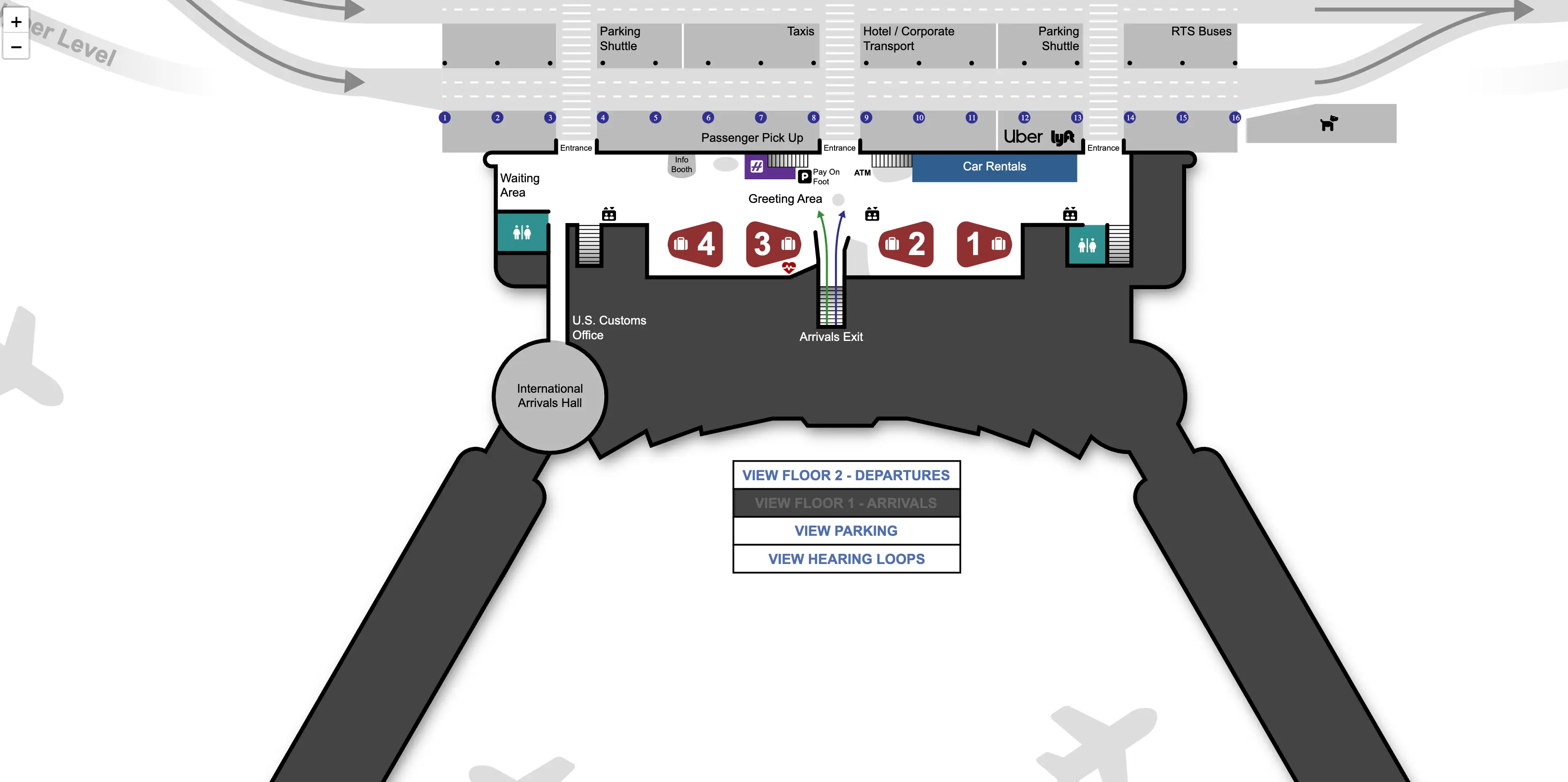
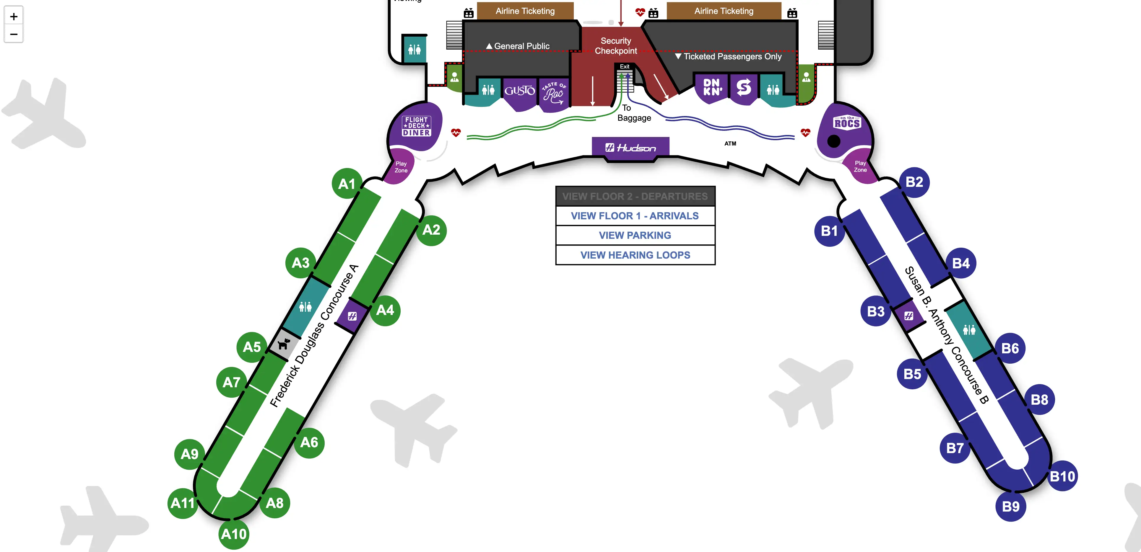
Frederick Douglass Greater Rochester International Airport is a compact, linear terminal stacked across two public levels, with Departures upstairs and Arrivals and Baggage Claim downstairs. The building reads like a short spine with a central atrium anchor and two airside arms (Concourse A and Concourse B). Across the greater Rochester airport complex, most landside walks are under a few hundred feet, but timing stress concentrates at single choke points (security, baggage belts, curb zones).
Map Table
| Level | Concourses | Baggage Claim | Curb System |
|---|---|---|---|
| Floor 2 (Departures) | A (right) / B (left) | — | Drop-off only |
| Floor 1 (Arrivals) | — | Carousels 1–4 | Columns 1–16 |
| Vertical Link | Central escalators/elevators | Directly at base | Lower level pickup/commercial |
Frederick Douglass Greater Rochester International Airport Map Strategy
- Frederick Douglass Greater Rochester International Airport is small, but the anxiety comes from choke points with low redundancy—treat baggage claim, the early-morning security bank, and the lower-level curb as precision zones.
- Use fixed labels as coordinates: the arrivals curb runs on Columns 1–16, and rideshare is anchored to the “B Entry” door sign—text a column number to your driver instead of “I’m outside.”
- Build a fallback loop before you need it: if parking looks full, switch to a shuttle lot plan early; if a shuttle is late, relocate to the marked commercial-lane pickup area rather than waiting at the wrong curb.
- For cancellations, assume rebooking is handled at your airline’s ticket counter on the departures level, while bag release may route through the airline’s baggage service office on the arrivals level—avoid unnecessary level changes.
2026 Frederick Douglass Greater Rochester International Airport Map + Printable PDF
Frederick Douglass Greater Rochester International Airport’s terminal layout remains a two-level, vertically separated flow in 2026, with a single consolidated security checkpoint upstairs and a four-carousel baggage hall downstairs. What changes traveler outcomes isn’t the footprint—it’s how fast you hit the right door, curb lane, and column number when bags run late or operations disrupt. A printable map is most useful when it highlights the column grid, the “B Entry” sign, and the central up and down core.
Frederick Douglass Greater Rochester International Airport Level 1 Arrivals Map 2026
Frederick Douglass Greater Rochester International Airport Level 2 Departure Map 2026
2026 Frederick Douglass Greater Rochester International Airport Map Guide
What is the exact walking distance (in feet/meters) from the arrivals corridor to the baggage claim belt area, measured along the public route (no staff-only shortcuts)?
The public walking distance is effectively immediate because the central escalators deposit arriving passengers directly into the baggage claim hall at belt level. From the base of the escalator or elevator bank, the nearest carousel edge is typically within about 50–100 feet (15–30 meters), depending on which side of the hall you step off onto.
Arriving passengers exit the secure corridor on the upper level, follow the one-way “Exit Ticketed Passengers Only” path to the central down core, then descend to Floor 1. The escalators open straight into the rectangular baggage claim room with Carousels 1–4; you’ll see the belts in front of you as you enter the hall, with rental car counters lining the perimeter wall nearby.
What is the exact walking distance from baggage claim to the rideshare / pickup zone, including which exit door is the correct one?
The walking distance is under 100 feet (about 30 meters) from the baggage claim carousels to the rideshare curb at the “B Entry” door on the arrivals level. The correct exit is the lower-level door labeled “B Entry,” which is the landmark used to anchor rideshare pickup.
From any carousel, walk toward the exterior doors facing the arrivals roadway and follow overhead ground transportation signs to rideshare. Confirm you are leaving on Floor 1 (Arrivals), not going upstairs to departures. Outside, align with the curb grid by spotting the numbered columns (1–16) and stay at the “B Entry” frontage so your driver’s geofence match is clean; request the ride only once you are at the curb.
What is the exact walking distance (in feet/meters) from the TSA checkpoint exit to the closest gate seating area in the terminal?
The walking distance is under 200 feet (about 60 meters) from the TSA checkpoint exit to the closest gate seating area, typically at Gate A1 or Gate B1. The nearest seating is reached by taking the first immediate turn into the concourse connector right after screening.
Post-security, you enter the central airside connector and the terminal bifurcates almost instantly: Concourse A is to the right (green streamer wayfinding), and Concourse B is to the left (blue streamer wayfinding). The closest gate lounges sit just inside each concourse entrance, so you’ll see seating clusters within a short straight-ahead walk after the initial left/right split near the central atrium connector.
Where is the shuttle-parking pickup curb located by door number / terminal entrance label, and what is the shortest walking path to it from the main terminal doors?
The shuttle-parking pickup curb is on the lower-level arrivals roadway in the commercial-lane shuttle zone, marked by “Parking Shuttle” signage rather than a single dedicated door label. The shortest path is to exit on Floor 1 to the commercial curb, then walk along the numbered columns to the first posted “Parking Shuttle” stop.
Shuttle activity mixes with hotel shuttles and buses on the same lower-level frontage, so use fixed anchors to avoid the wrong curb: stay on Arrivals (Floor 1), not the upstairs drop-off road, and look for the commercial-lane markings and shuttle/bus signage near the terminal face. If you exit near the center doors, the RTS bus stop area is typically around Columns 8–9; from there, scan adjacent curb sections for the “Parking Shuttle” stop markers and stand directly at that signpost so drivers can spot you.
Where is the oversize baggage pickup location (if separate), and what is the shortest public walking route from the nearest baggage carousel?
Oversize baggage is delivered adjacent to your assigned carousel rather than to a separate oversize room. The shortest route is to stay at the carousel that served your flight and walk a few steps to the nearby oversize drop area or belt-side door where ground staff place skis, golf bags, and strollers.
ROC typically uses a dedicated oversize door or slide immediately beside the active carousel, near the belt induction point where items enter the system. From the carousel edge, scan the clear floor zone next to the carousel’s “feed” side and the nearby wall segment where staff can stage large items. If your item doesn’t appear, check the airline’s baggage service office along the perimeter of the same baggage claim hall rather than leaving the room to search for an “oversize” sign elsewhere.
Where is the airline baggage service office physically located relative to the baggage claim belts (left/right, door labels), for filing a delayed-bag report?
The airline baggage service offices are on the arrivals level inside the baggage claim hall, positioned along the perimeter walls near the corners rather than in the middle of the carousels. Most counters sit adjacent to the carousel groupings, so you can file a report without leaving Floor 1.
In practice, carriers using Concourse A commonly cluster closer to Carousels 1–2, while carriers using Concourse B commonly cluster closer to Carousels 3–4. Use fixed landmarks to triangulate: the rental car counters line the same baggage hall perimeter, and the exterior curb doors face the Columns 1–16 frontage. If an office is closed (often late night), the fallback is your airline’s ticket counter upstairs on the departures level, reached by the central elevators/escalators.
What is the exact walking distance from the ticketing/check-in counters to the TSA checkpoint entrance, following the normal passenger route?
The walking distance is about 100–200 feet (30–60 meters) from the ticketing/check-in counters to the TSA checkpoint entrance on the departures level. The route is direct and stays on the same continuous upper-level hall.
From your airline’s counter line, walk straight toward the centrally positioned security queue; the checkpoint is designed for clear line-of-sight, so you can usually see the stanchions and TSA signage from the ticketing area. During the early-morning departure bank, the line can back up into the ticketing lobby, so the practical “distance” becomes the queue footprint—if the stanchions extend past the central atrium area, plan extra time even though the physical walk is short.
Where is the “problem desk” / customer service counter area for handling cancellation rebooking, and what fixed landmarks (signs/doors) anchor its position?
The rebooking “problem desk” is your airline’s own ticket counter on the departures level, not a centralized airport-wide customer service desk. The fixed anchor is the Floor 2 ticketing hall directly opposite the consolidated TSA checkpoint area in the same upper-level space.
If you are landside, go straight to your carrier’s check-in counters on the upper level and queue at the staffed positions for rebooking. If you are already airside, the first contact is the gate agent, but the fallback under heavy disruption is to exit through the one-way “Exit Ticketed Passengers Only” lane, return to the departures lobby, and use the ticket counters for full-service changes. For baggage release after a cancellation, the anchor shifts downstairs to the baggage claim hall and the airline’s baggage service office along the perimeter wall.
What is the exact walking distance from rental car counters to the rental car pick-up stalls, including which doors/exit to use?
The walking distance is 125 feet (about 38 meters) from the rental car counters to the rental car pick-up stalls in the garage across the roadway. The correct exit is the arrivals-level exterior doors adjacent to the rental car counter row, typically on the Columns 1–4 side of the lower-level frontage.
Complete your paperwork at the counters on Floor 1, then exit through the nearest doors by the rental desk area to the arrivals curb. Use the marked pedestrian crosswalk to cross the commercial roadway directly into the parking garage entrance and proceed to the lower level where the rental stalls are staged. There is no rental shuttle at ROC for on-airport rental cars, so if you find yourself looking for a bus stop, you’ve overcomplicated the route.
Where is the cell phone waiting lot entrance relative to the terminal loop, and what is the fastest legal driving path from the lot back to passenger pickup?
The cell phone waiting lot entrance is on Airport Way on the approach to the terminal loop, positioned on the right-hand side before you enter the arrivals curb roadway. The fastest legal return is to exit the lot back onto Airport Way, follow the signed merge toward Arrivals (lower level) pickup, then enter the terminal loop and drive directly to the column number your passenger texts you.
Drivers access the lot from Airport Way prior to the terminal frontage, using a clearly signed entrance often marked with feather flags. After staging, follow lot exit signage to rejoin Airport Way and continue into the arrivals roadway; typical drive time from lot to curb is about 2 minutes under normal flow. A roundabout at Airport Way and Airport Road feeds this pattern—missing the correct turn forces a full loop around the terminal road system, which can add several minutes during peak pickup waves.