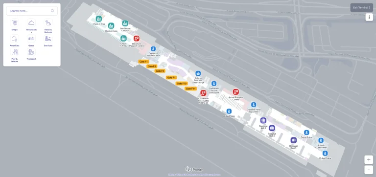
Erie Airport Terminal Map
Location: Erie, Pennsylvania
Your entryway to a hassle-free trip through the lakefront city of Pennsylvania is the Erie Airport Terminal map.
Erie International Airport (ERI), also known as Tom Ridge Field, is a public airport located 5 miles southwest of Erie, Pennsylvania. It features two runways, with the main runway 6/24 extending 8,420 feet, and offers limited commercial flights operated by American Eagle and Breeze Airways as of January 2025
The terminal has everything you need, whether you’re planning a trip to Presque Isle State Park, checking into the opulent Sheraton Erie Bayfront Hotel, or traveling to the Bayfront Convention Center.
Your vacation will go much more smoothly because getting in and out is quick and uncomplicated, from easy baggage claim to convenient parking. Go here to begin your Erie journey!
ERI Airport Terminal – Overview Map 2024

ERI Airport Terminal – Runway Map 2024

ERI Airport Terminal – Parking Map 2024

FAQ
How many gates does Erie Airport have?
Erie Airport (ERI) has four gates in its terminal, providing services for commercial flights.
How early should I get to the ERIE airport?
Arriving 90 minutes to 2 hours before your flight at Erie Airport is recommended for check-in, security, and boarding.
What airlines fly out of Erie, PA airport?
Erie Airport (ERI) is served by American Airlines and United Airlines, offering flights to major hubs like Chicago and Charlotte.
How big is Erie Airport?
Erie International Airport (ERI) covers approximately 450 acres, with a single terminal and one main runway.