Eppley Airfield South Terminal Map (Most Up-To-Date)
Eppley Airfield’s South Terminal currently works like a two-level “island” attached to a parking garage hub, with the building split into landside processing on Level 1 and TSA/gates on Level 2. During the Build OMA phase within Omaha’s main airport grounds, the center of the terminal is physically severed, so North vs South operations don’t flow together indoors. Most vehicle access now funnels into the South Garage, not a traditional curb in front of the terminal.
Map Table
| Zone | Connection | Walk Time |
|---|---|---|
| South Garage Level 1 | Center Median crosswalk → Door 1 / Door 2 | 3–4 min |
| Door 1 entry (South side) | Elevators/escalators → Level 2 mezzanine | 1–3 min |
| Level 2 mezzanine | TSA queue → Gates A1–A10 | 2–5 min |
| South Garage Level 3 | Skywalk → Level 2 (near TSA side) | 2–4 min |
Eppley Airfield South Terminal Map Strategy
- Commit to the correct side before you turn in: South Terminal airlines and South Garage access are a binary choice, and the central interior crossing is not a reliable option during construction.
- Treat South Garage Level 1 as the curb: pickup, drop-off, and shuttle unloading cluster by the Center Median crosswalk opposite South-side doors, not along a traditional terminal frontage.
- Pin “Door 1” as the default South navigation node: it’s the cleanest way to find the South vertical core (elevators/escalators) up to Level 2 for TSA and gates.
- If you mis-park North vs South, recover via the Center Median walkway outdoors: don’t hunt for an interior fix—take the exposed connector and re-enter at South Door 1/2 to avoid blocked sections.
2026 Eppley Airfield South Terminal Map + Printable PDF
Active Build OMA construction continues to enforce a true North/South split, with interior cross-terminal movement constrained by the central work zone. The practical “curb” for South Terminal traffic remains inside the South Garage (Level 1), while security and boarding live on Level 2. A printable map matters most for choosing the correct garage/door before arrival so you don’t trigger an outdoor backtrack.
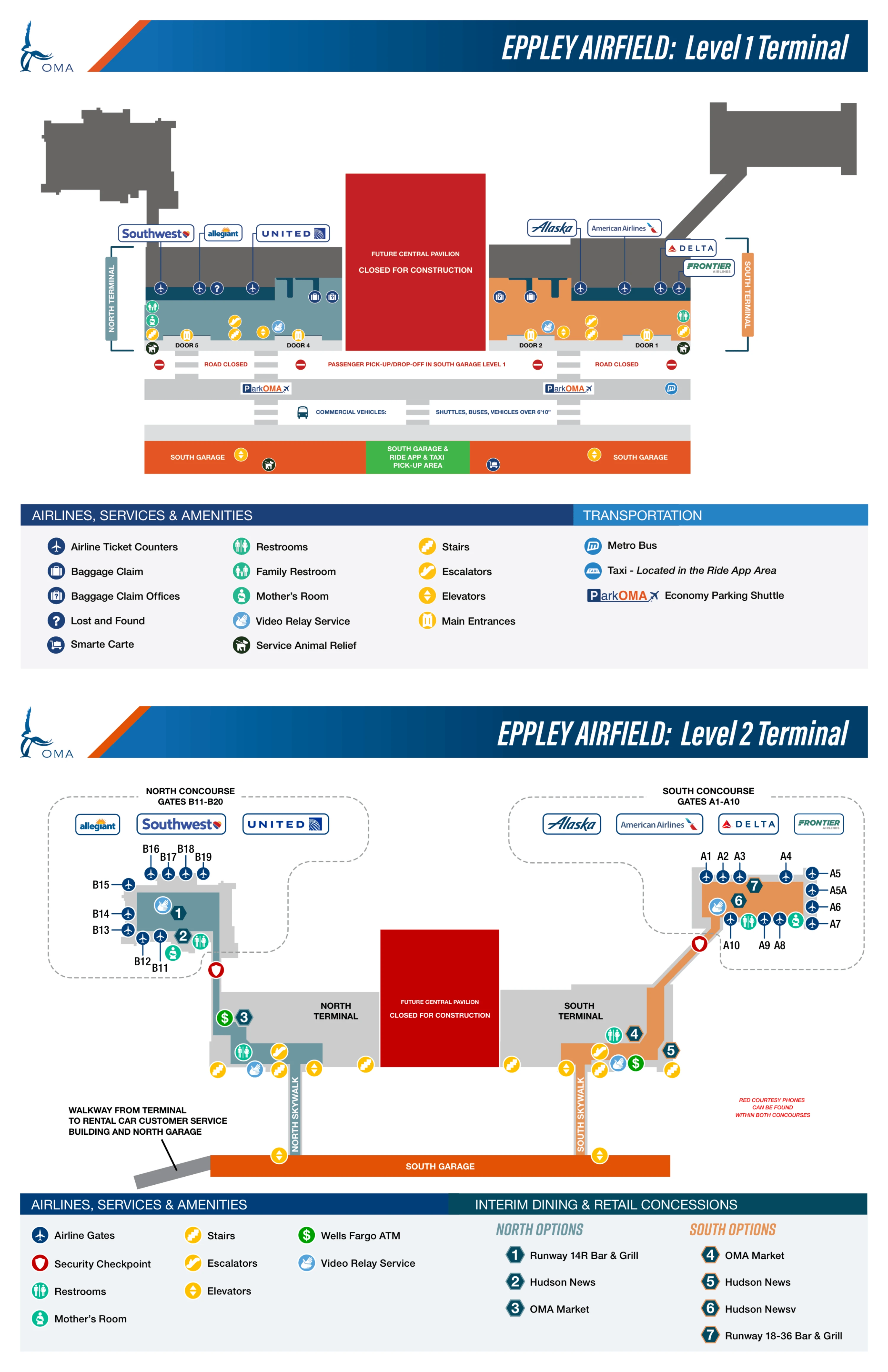
Eppley Airfield South Terminal Level 1 Map 2025-2026
Eppley Airfield South Terminal Level 2 Map 2025-2026
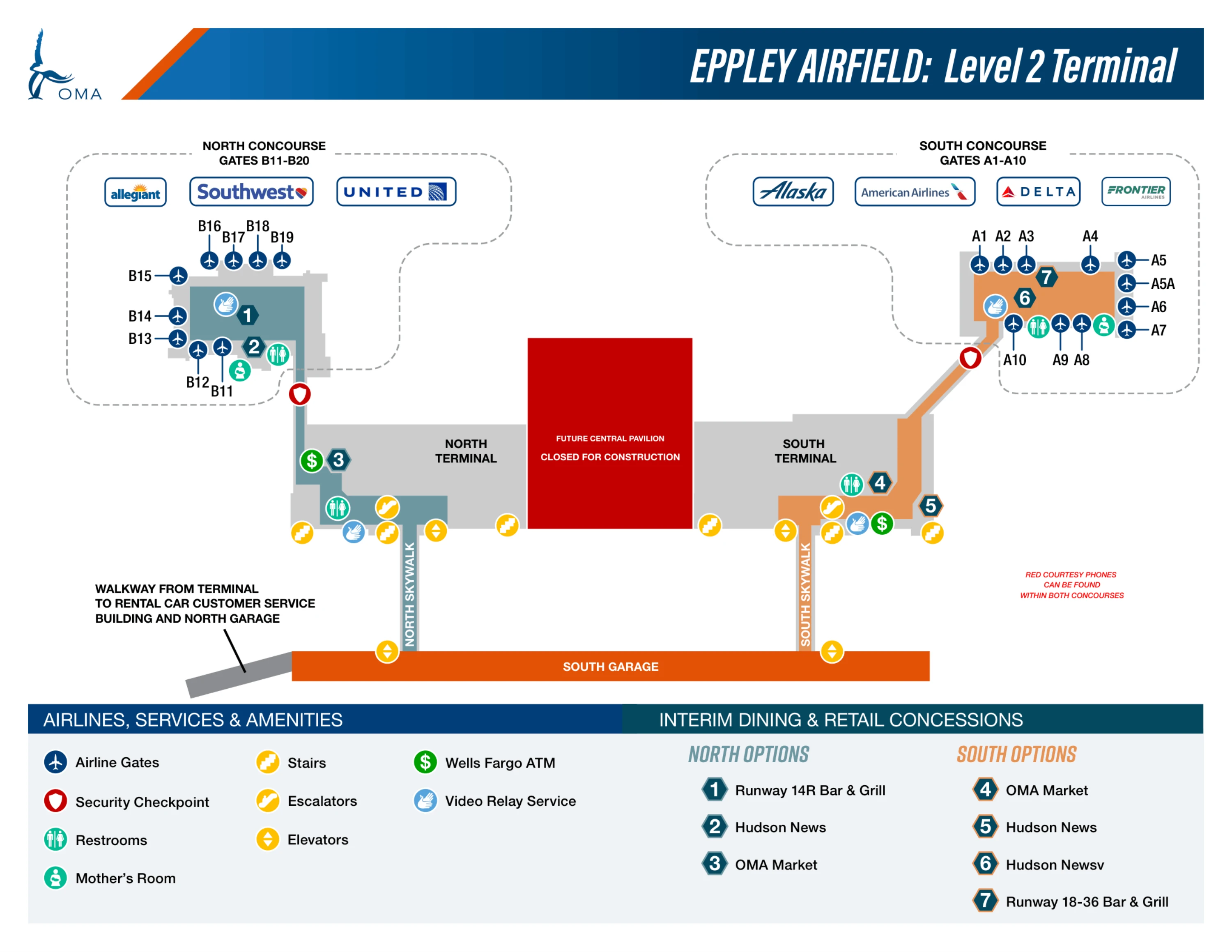
2026 Eppley Airfield South Terminal Map Guide
What is the exact entry point (door/location) where the Level 2 connecting tunnel from the garage delivers you into the South side of the terminal?
The Level 2 garage connector delivers you into the South Terminal on the Level 2 mezzanine at the Skywalk entry, immediately on the landside side of the TSA area. The entry lands on the South mezzanine corridor south of the central construction partition, putting you on the same level as the South security checkpoint approach.
The practical way to confirm you’re in the right spot is what you see around you: the corridor space between the Skywalk door and the South elevator/escalator landing is the same area that becomes the TSA queue spillover zone during early-morning peaks. From this Skywalk entry, the South TSA checkpoint is reached by following the Level 2 landside flow toward the visible queue stanchions rather than descending to Level 1.
What is the exact curbside drop-off location for the South terminal under the current “drive-through-the-garage” routing (specific curb/zone name)?
The South Terminal drop-off occurs inside the South Garage on Level 1 in the passenger pick-up/drop-off lanes beside the Center Median crosswalk, opposite South-side Door 1 and Door 2. The drop-off is not on a traditional terminal-front curb; it’s in the garage lane system that functions as the curb during construction.
Drivers enter the South Garage and follow signage for passenger drop-off, then stop in the flow-through lane area aligned with the Center Median pedestrian path. The landmark triangulation is the crosswalk that feeds directly toward Door 1 (the South-side entry that leads to the main elevator/escalator bank) rather than turning toward the central construction wall.
What is the exact arrivals pickup curb location for the South terminal (which level + which side of the South garage frontage)?
Arrivals pickup for the South Terminal is on South Garage Level 1 in the same passenger pick-up/drop-off lane system used for departures, along the Center Median frontage facing the terminal. The pickup curb is not separated to a different level; both streams compress into Level 1 during this construction phase.
The reliable landmark is the Center Median pedestrian path and its marked crosswalks: passengers stage on the median and cross to the garage-side lanes for vehicle loading. If you’re oriented to the terminal face, you want the Level 1 garage frontage opposite Door 1/Door 2 (the South doors) rather than drifting north toward the construction hoardings and Door 5 area.
What is the exact shortest walking route (map path) from South terminal baggage claim to the South garage exit without entering restricted/blocked interior sections?
Walking from South baggage claim to the South Garage is shortest by exiting at South Door 1 or Door 2 to the Center Median walkway, then crossing at the marked crosswalk into South Garage Level 1. The interior cross-terminal path toward the central construction zone is the wrong move because it dead-ends into blocked sections.
From baggage claim on Level 1, move toward the terminal face and pick the nearer of Door 1 or Door 2, then step outside to the Front Drive/covered walkway zone. Walk straight onto the Center Median and use the designated crosswalk over the active lanes (including the commercial/shuttle lane) into the garage opening on Level 1. Stay perpendicular to the terminal face; don’t angle left toward the construction wall where circulation is constrained.
What is the exact walking distance (feet/meters) from the South garage pedestrian exit to the South terminal security checkpoint entrance?
Walking distance from the South Garage pedestrian exit to the South TSA checkpoint entrance is approximately 300–450 feet (90–140 meters), depending on whether you enter at Door 1 or Door 2 and how direct the interior path is to the vertical core. This assumes you use the standard Level 1 crosswalk-to-door entry and then go up to Level 2 for security.
The shortest common path runs South Garage Level 1 → Center Median crosswalk → Door 1 → elevator/escalator bank just inside Door 1 → Level 2 mezzanine → TSA queue entrance. As a field check, the garage-to-door segment is roughly 150–200 feet, the door-to-vertical-core segment about 50 feet, and the Level 2 landing to the checkpoint approach about 100 feet, with the rest being circulation around the elevator/escalator area.
Where are the elevators located on the South terminal approach path (relative to the main entrance) for travelers arriving with heavy checked luggage?
The South elevator bank is immediately inside South Door 1, positioned to the right and slightly forward from the entrance vestibule. This is the primary vertical connector from Level 1 up to the Level 2 mezzanine where TSA screening and the South gates corridor begin.
Entering through Door 1 from the Center Median/crosswalk, keep your line tight to the right-hand side to spot the elevators and adjacent escalators grouped together. If you walk deeper into Level 1 toward baggage claim or drift toward the central construction partition, you’ll likely have to backtrack to reach this vertical core, which is why Door 1 is the safest “heavy luggage” entry node.
If a traveler parks in the wrong garage (North vs South), what is the exact outdoor connector route between the two terminal entrances (shortest walk, step-by-step on map)?
There is no interior connector between North and South operations during the current construction split, so the shortest recovery route is the Center Median outdoor walkway. The penalty is an exposed walk past the Central Pavilion construction hoardings, then re-entry at South Door 1 or Door 2.
Exit the North side at Level 1 via Door 5 and step onto the Center Median pedestrian path that runs parallel to the terminal face. Walk south along the median, staying on the pedestrian channel beside the active garage/traffic lanes, and continue past the central construction barrier until the South-side door cluster comes into view. Re-enter at Door 1 for the fastest access to the South elevators/escalators (or use Door 2 if it’s closer to your position), then proceed to Level 2 for TSA.
Where is the exact economy-lot shuttle waiting tent located on Abbott Drive (pinpoint position + nearest garage/landmark)?
The economy-lot shuttle waiting tent is on Abbott Drive at the South Canopy area near the South Economy Parking Lot, adjacent to the South Cell Phone Waiting Lot. The pickup point sits on the airport’s Abbott Drive approach corridor on the south side of the terminal approach zone rather than at a traditional terminal-front curb.
Use the South Cell Phone Waiting Lot as the landmark anchor: the tent is positioned at the South Canopy staging area along Abbott Drive where the economy shuttle service consolidates riders during its peak operating window. From there, shuttles run into the garage-centric interface for South Terminal access.
What is the exact drop-off point where the economy shuttle unloads for South-terminal-bound passengers (specific curb/door/zone)?
The economy shuttle unloads at South Garage Level 1 in the Commercial Lane, aligned with the Center Median crossing that leads toward South Door 1. This is not a terminal-front curb stop; the shuttle drop is embedded in the garage-level traffic system used for South-side access.
After unloading in the Commercial Lane, passengers cross the private-vehicle lanes using the marked crosswalks to reach the Center Median pedestrian path. From the median, the most direct re-entry is via Door 1, which is the cleanest handoff to the South elevator/escalator bank for Level 2 security and Gates A1–A10.
Where is the South terminal TSA queue overflow area located on the map when early-morning lines back up (corridor/landmark the line spills into)?
The South TSA queue overflow backs up into the Level 2 landside mezzanine corridor between the South Skywalk entry and the landing area of the South elevators/escalators. This is the primary circulation strip on Level 2 that connects the garage-to-mezzanine arrival nodes to the checkpoint stanchions.
In the early-morning surge window, the tail of the line occupies the open corridor space where Skywalk arrivals expect to walk straight toward TSA. The landmark triangulation is the Skywalk door on one end and the elevator/escalator landing zone on the other, with the queue expanding into that shared passage when stanchioned space at the checkpoint fills.
Where is the only post-security food option in the South terminal located (nearest gate/landmark on the airside map)?
The only post-security hot-food option in the South Terminal is Runway 18-36 Bar & Grill, located airside in the South Concourse serving Gates A1–A10. The venue sits in the concourse holdroom zone after the South TSA checkpoint, positioned as the primary dining landmark for the A-gates.
If you’re using the airside map, triangulate from the A-gate corridor: Runway 18-36 is the single full-service food anchor in the South Concourse, with the nearest “backup” being Hudson News for packaged snacks in the same Gates A1–A10 airside footprint.
Where is the pre-security coffee counter in the South terminal located relative to the security entrance (exact position on the landside map)?
The pre-security coffee counter is OMA Market in the South Terminal landside lobby immediately before the Level 2 TSA checkpoint approach. It sits in the same public mezzanine zone where passengers arrive from the Door 1 elevator/escalator landing, just short of the security queue area.
From the South Garage entry flow, go Door 1 on Level 1, take the South elevators/escalators up, and look in the Level 2 landside lobby space before you step into the TSA stanchions. The easiest landmark triangulation is the Level 2 elevator/escalator landing: OMA Market is positioned in that public lobby area that also connects toward the Skywalk corridor, making it the last grab-and-go stop before entering the checkpoint line.
Archive Eppley Airfield South Terminal Map
Below are all historical map versions for Eppley Airfield. Each year includes the official map available for that period, presented as both WebP and PDF.
2025-2026 Eppley Airfield South Terminal Map (Official 2025 Edition)