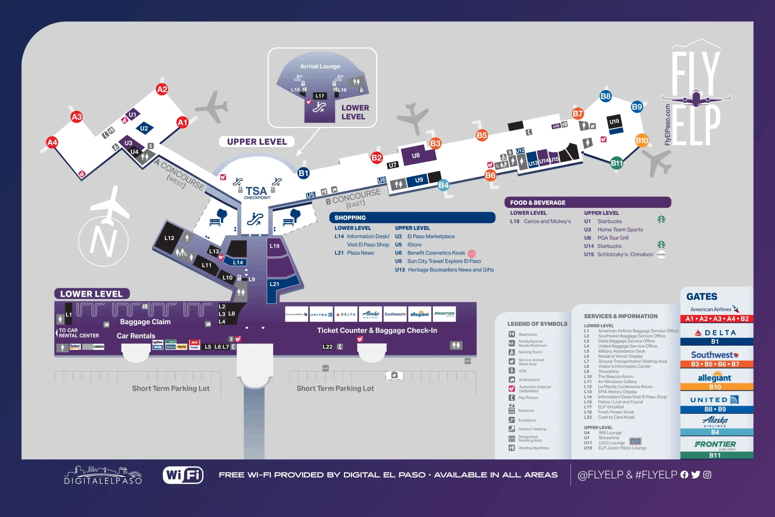
El Paso International Airport Map (Most Up-To-Date)
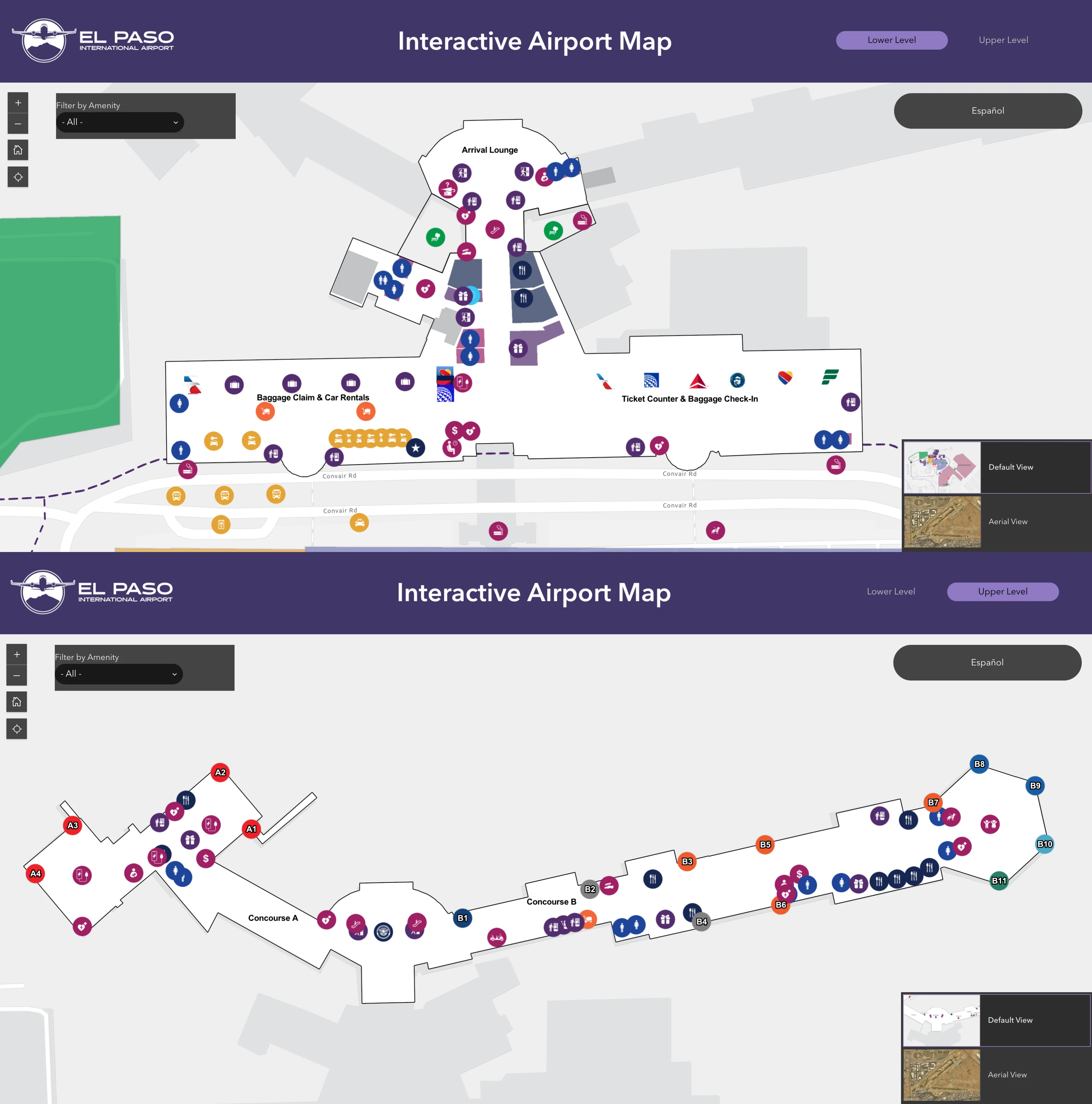
El Paso International Airport (ELP) runs as a single, centralized terminal with one main curb and a compact two-concourse airside split (Concourse A west, Concourse B east). Within El Paso’s main airport grounds, all passengers funnel through the same vertical choke point: the central escalators up to the lone TSA checkpoint on the Upper Level. The footprint is small, but the layout’s time-risk is real because security queues can spill back down into the landside lobby.
Map Table
| Terminal Layout | TSA Location | Concourses | Curbside Door Zones |
|---|---|---|---|
| Single main terminal | Upper Level, central | A (West) • B (East) | Zone 1 (Doors 1–2) • Zone 2 (Central) • Zone 3 (Doors 3–4) |
El Paso International Airport Map Strategy
- Treat TSA as a vertical time-risk: the line can start upstairs or downstairs, so check the La Placita escalator base first and do not “go up to look” if a downstairs queue exists.
- Use the shortest curb-to-TSA geometry: Door choice matters because the ticketing hall is long; mismatch (Door 3/4 for Southwest, for example) adds hundreds of feet before you even reach the escalators.
- Assume no secret shortcut routes: there’s no alternate security entrance, no tram, and no airside connector that bypasses the checkpoint—every concourse passenger goes through the same choke point.
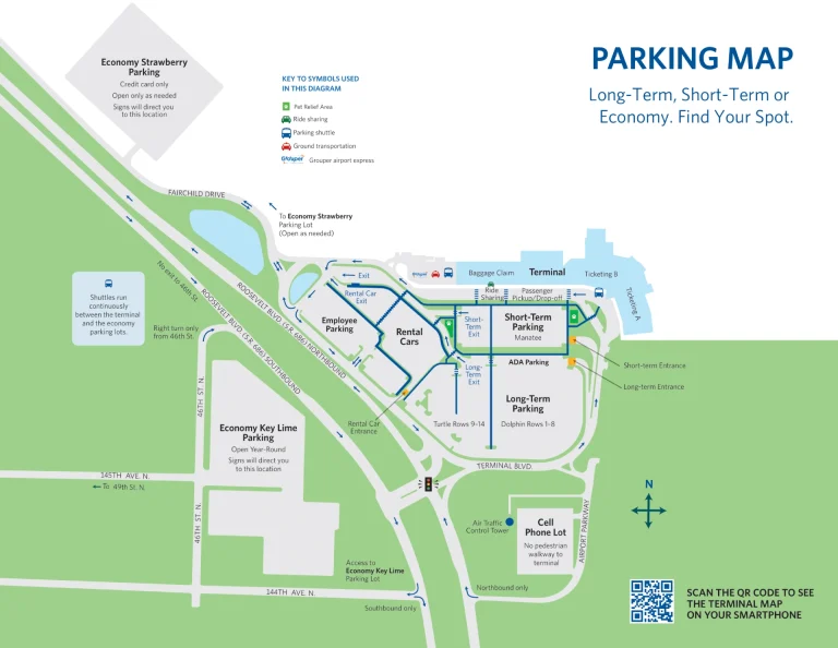
- Treat rideshare and parking as time multipliers: rideshare pickup is curbside by Baggage Claim Doors 3/4 (past the taxi line), and Long-Term parking is shuttle-dependent, so buffer for curbside friction plus shuttle wait.
2026 El Paso International Airport Map + Printable PDF
Operationally, 2026 travel at ELP still hinges on the same constraint: one TSA checkpoint above the central atrium, with limited upstairs queue capacity that can force the line to start downstairs near La Placita during peak banks. Parking and curb access remain straightforward, but capacity shifts (including premium/short-term disruptions) can push more people into longer first-mile paths and add variability to curb-to-TSA timing.
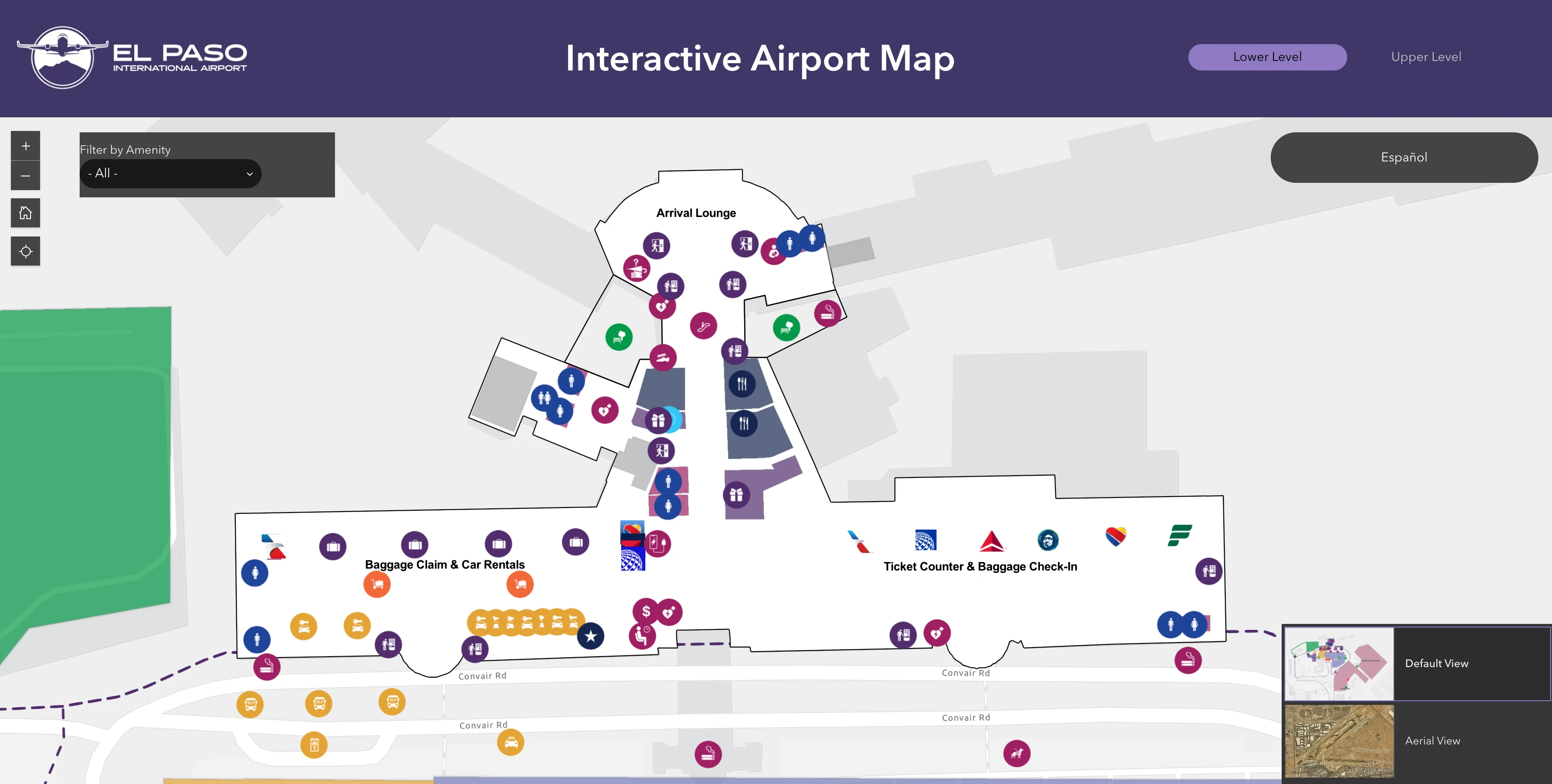
El Paso International Airport Lower Level Map 2026
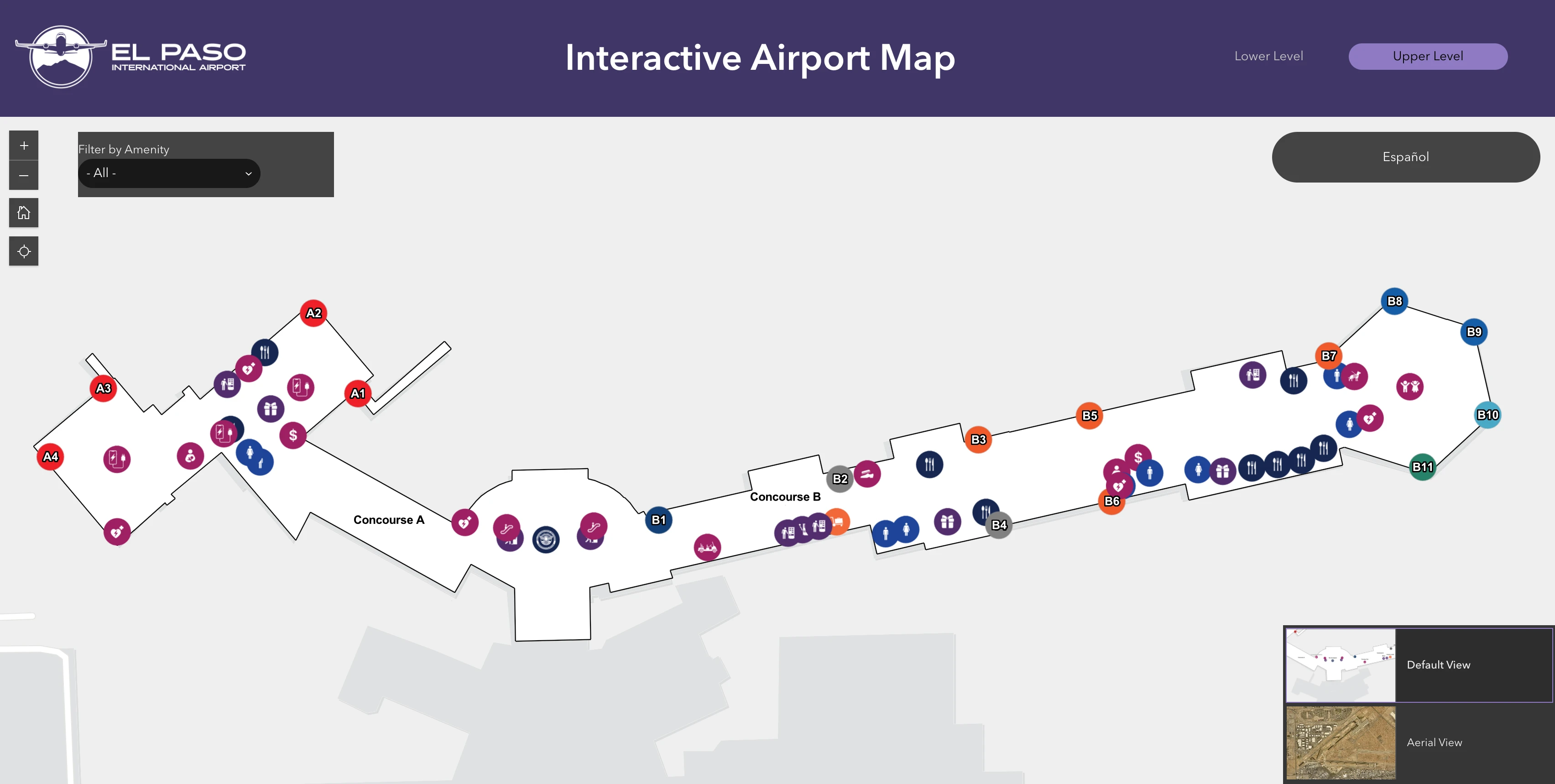
El Paso International Airport Upper Level Map 2026
2026 El Paso International Airport Map Guide
What is the exact walking distance from the Long-Term Parking pedestrian access point to the TSA checkpoint entrance at ELP?
Shuttle dependency makes a true “pedestrian access point” distance to TSA unreliable because the Long-Term lot is not designed for a consistent walk-in path. The practical walk begins at the terminal curb/doors after the shuttle drop, then continues inside to the central escalators and TSA on the Upper Level.
The repeatable, map-stable segment is from terminal entry to TSA: the shortest path runs from the central doors (Zone 2) through the La Placita atrium to the escalators, then up to the checkpoint, at roughly 200 feet of lateral travel plus the vertical escalator transition. Walking from the Long-Term lot itself is a negative constraint at ELP: no dedicated pedestrian infrastructure for a safe, direct terminal walk from the far reaches of the lot.
What is the exact walking distance from the rideshare pickup zone to the baggage claim exit doors at ELP?
Walking is about 150–200 feet (around 2 minutes) from the Ride App Pickup curb segment back to the Baggage Claim exit doors at ELP. The path is flat, curb-adjacent, and anchored to Doors 3 and 4 on the Lower Level.
The pickup zone sits outside Baggage Claim on the same lower curb line: exit at Door 3 or Door 4, then follow the sidewalk along the curb to the “Ride App Pickup” signed segment positioned just past the taxi queue. The direction cue is the taxi line itself—if you’re standing at rideshare and walk back toward the terminal frontage, the first major set of sliding doors you reach is the Baggage Claim exit (Doors 3/4). No shuttle or remote rideshare lot is involved at ELP.
What is the exact walking distance from the TSA exit to the farthest departure gate in the terminal at ELP?
Walking is about 900–1,000 feet from the TSA exit to the farthest gate at ELP, Gate B11 in Concourse B. That’s typically a 4–6 minute walk at an average pace, with no tram, shuttle, or moving walkway.
After clearing the checkpoint, the airside hub immediately splits left to Concourse A and right to Concourse B. Follow the Concourse B direction from the TSA exit, then continue straight down the east pier toward the last gate positions; the “long walk” ends at Gate B11 near the far end of the Concourse B corridor. A negative constraint at ELP is that you cannot shortcut between concourses without first clearing TSA—every gate path starts at the same checkpoint exit.
Which specific curbside door/zone is closest to the ticketing hall entrance for the shortest curb-to-check-in walk at ELP?
Zone 1 (Doors 1–2) is the shortest curb-to-check-in entry for Southwest and American, while Zone 3 (Doors 3–4) is the shortest curb-to-check-in entry for Delta, United, Allegiant, and Frontier. The “closest door” is airline-dependent because ticketing counters anchor the west and east ends of the same long landside hall.
| Airline / Use Case | Best Curb Zone | Closest Door Cluster | Interior Anchor Point |
|---|---|---|---|
| Southwest • American | Zone 1 | Doors 1–2 (West End) | West ticketing counters |
| Delta • United • Allegiant • Frontier | Zone 3 | Doors 3–4 (East End) | East ticketing counters |
| No checked bags • fastest line to escalators | Zone 2 | Central doors | La Placita atrium / escalator base |
Where does the TSA queue physically begin in the pre-security lobby (exact anchor point/landmark where the line starts) at ELP?
The TSA queue begins at the base of the central escalators beside the La Placita atrium landmark when the checkpoint is in spillover mode. When volume is normal, the line begins upstairs in the stanchions directly in front of the TSA ID podiums on the Upper Level.
The queue “start” flips because the Upper Level holding area is small: once it fills, the line backflows down the escalator/stair area and forms a serpentine on the Lower Level around La Placita. Use the statue/La Placita as your first visual check from any entry door; if people are queued there, that is the end of the general line and going upstairs becomes a negative constraint (you’ll be turned back down and lose position). In extreme surges, the tail can extend toward the Rental Car Center entrance corridor.
What is the exact walking distance from the car rental counters to the baggage claim carousel area at ELP?
Walking is essentially inside-the-same-hall distance—about 40–100 feet from the rental car counter area to the baggage claim carousel area at ELP. The counters are located in or immediately adjacent to the Baggage Claim hall on the Lower Level.
From the carousel line, you’ll see the rental counters along the same interior frontage; you do not exit the building or take a shuttle to reach them. The adjacent anchor is the Baggage Claim hall itself: if you’re facing the carousels, the rental counter desk line is within a few dozen steps along the same corridor. A key negative constraint is that there’s no separate remote rental facility you need to “find” first—don’t waste time looking for a shuttle stop before completing the counter process.
Which exact driveway/curb lane is designated for rideshare drop-offs, and where does it merge/split relative to standard passenger drop-off at ELP?
No dedicated rideshare drop-off lane exists at ELP; rideshare drop-offs use the same standard passenger drop-off curb lanes on the Terminal Drive frontage. The only functional “split” is operational rather than physical: the curb is segmented by door zones, not by a separate Uber/Lyft driveway.
Rideshare vehicles approach and enter the same curbside circulation as private cars, then load/unload at the door zone you choose (Doors 1–2 for Southwest/American, Doors 3–4 for Delta/United/Allegiant/Frontier, or the central doors for fastest access to La Placita and the escalators). A negative constraint is that you cannot follow signs to a special rideshare drop pad—those typically apply to pickup, which is signed as “Ride App Pickup” on the lower curb outside Baggage Claim past the taxi line.
What is the exact outbound driving route from the terminal exit roadway to reach the correct freeway on-ramp (direction-specific) at ELP?
Reaching I-10 from ELP is the Airway Boulevard route: exit the terminal loop onto Convair Road, stay left/center for Airway Blvd, turn south on Airway, then use the I-10 interchange ramps for eastbound or westbound. The critical decision happens immediately after leaving the terminal area because the Airway Blvd versus Spur 601 paths diverge quickly.
| Destination Direction | From Terminal Exit Roadway | Key Turn / Ramp | Landmark Split to Confirm |
|---|---|---|---|
| I-10 West (Downtown / Las Cruces) | Convair Rd → Airway Blvd | Right ramp at I-10 interchange to I-10 W | Airway Blvd signage (not “Airport Rd”) |
| I-10 East (Van Horn / San Antonio) | Convair Rd → Airway Blvd | Left ramp at I-10 interchange to I-10 E | Airway Blvd signage (not Spur 601) |
| Spur 601 / Fort Bliss / Loop 375 | Convair Rd → Airport Rd / Global Reach Dr | Follow Spur 601 East signs | “Airport Rd” (not “Airway Blvd”) |
A negative constraint at ELP is that drifting into the wrong vector is hard to “fix” quickly: if you take Airport Rd/Spur 601 by mistake when you meant I-10, you’ll be committed east/northeast before you can safely reroute.
Archive El Paso International Airport Map
Below are all historical map versions for El Paso International Airport. Each year includes the official map available for that period, presented as both WebP and PDF.
2021 El Paso International Airport Map (Official 2021 Edition)