Edinburgh Airport Map (Most Up-To-Date)
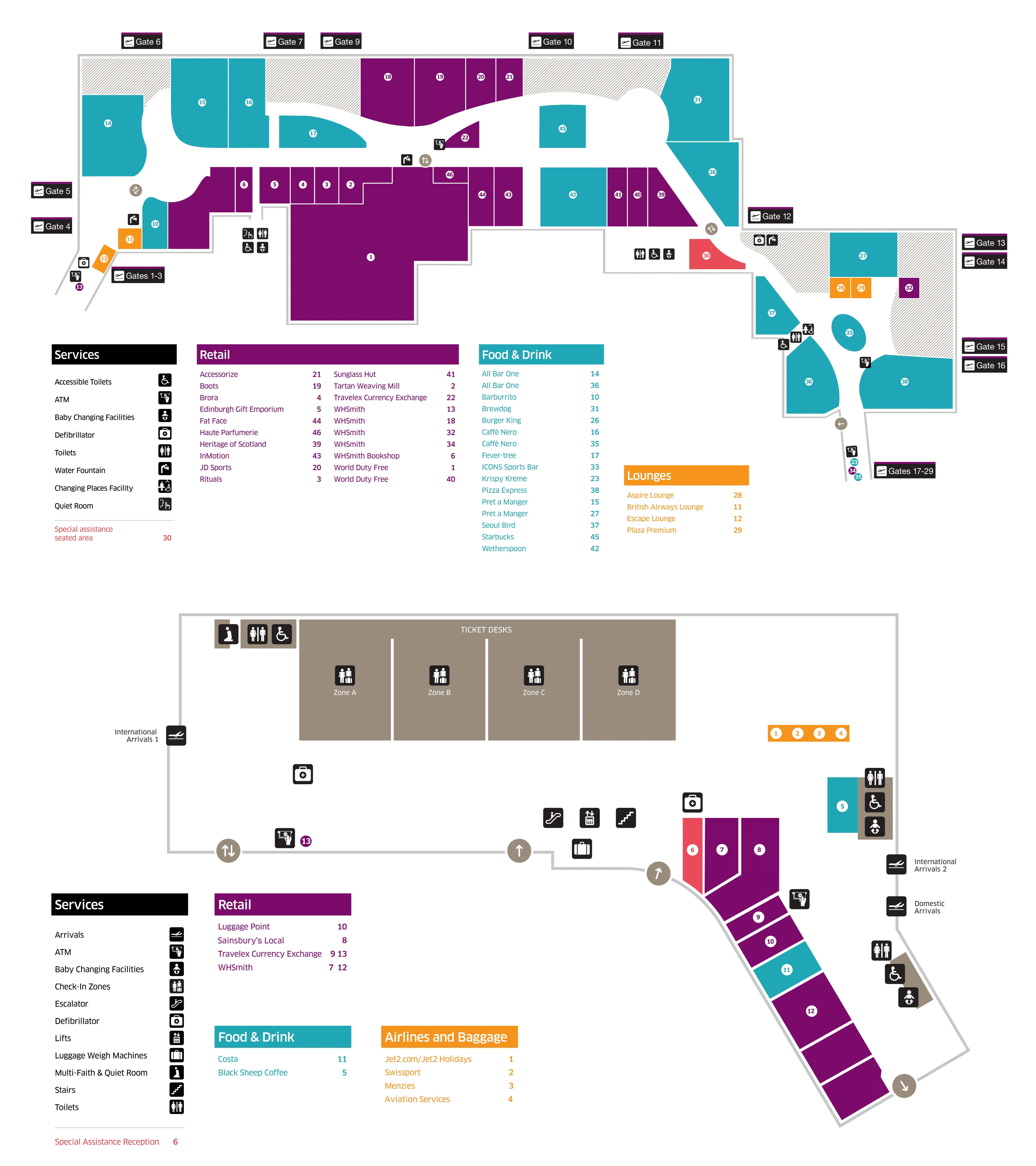
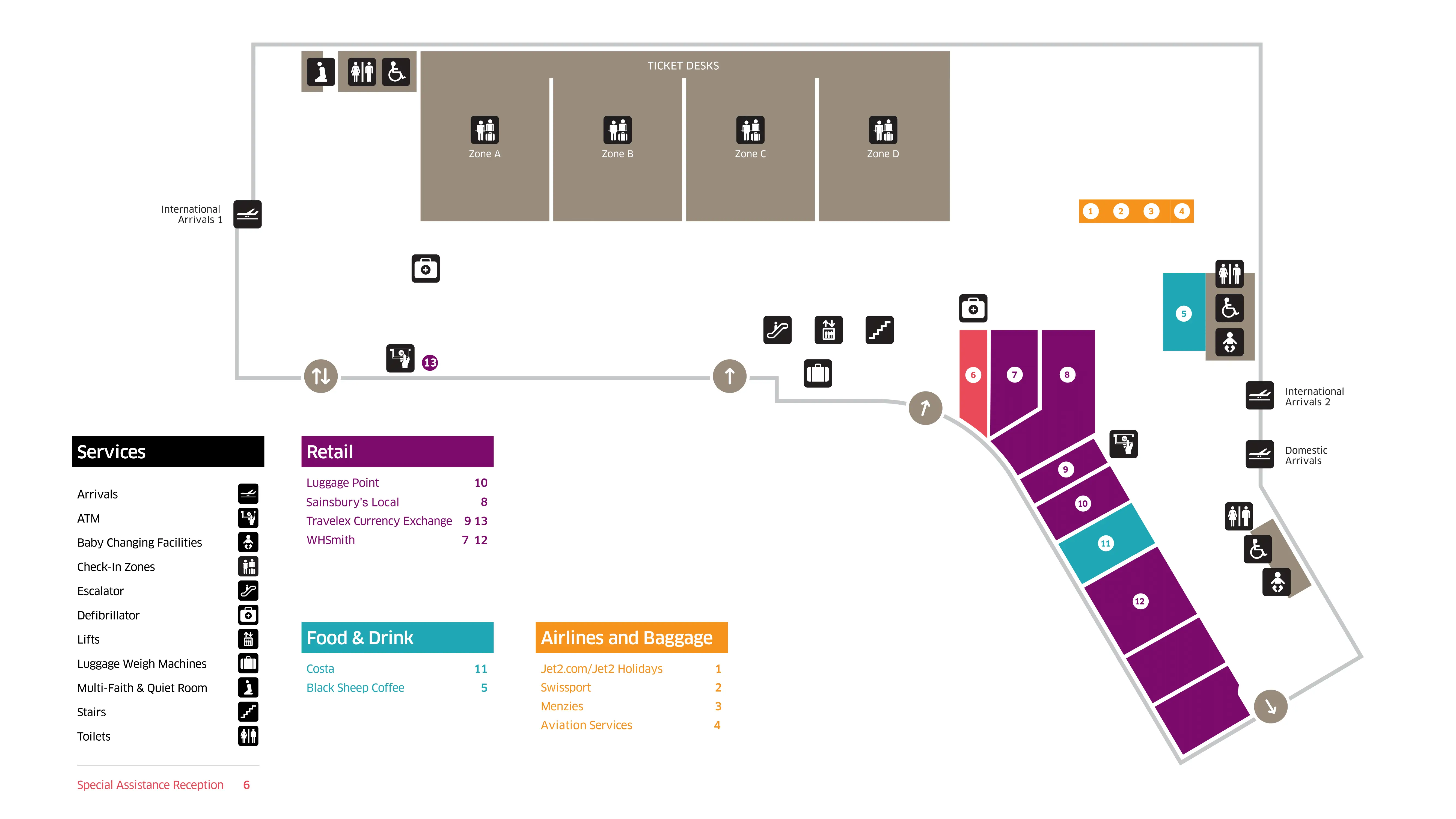
Edinburgh Airport (EDI) runs as a single-terminal “barbell,” with landside processing spread left–right on the Ground Floor (Zones A–D) before compressing into one First Floor security entry and a forced World Duty Free path, then splitting again along the east/west piers. Within the EDI hub, most onward links cluster at the East Terminus plaza, so treat the layout as east-facing with one major vertical choke point that drives most delays and confusion.
Map Table
| Terminal | Key Airlines | Primary Function | Transfer Mode |
|---|---|---|---|
| Single Terminal | Ryanair, easyJet, Jet2, British Airways | Ground: check-in, Arrivals hall • First: security, duty-free, gates | Tram (East Terminus) • Airlink 100 (Stop A) • Official taxis (East Terminus) • MSCP Paid Pickup & Dropoff |
Edinburgh Airport Map Strategy
- Treat Arrivals as two hard stops: passport control first, then baggage reclaim; expect the queue to back up into the approach corridors/stairwells when it overflows.
- For Departures, decide your check-in zone before you enter the hall: Zone A (Ryanair/easyJet) far left, Zone D (Jet2) far right; the centerline is a cross-flow trap.
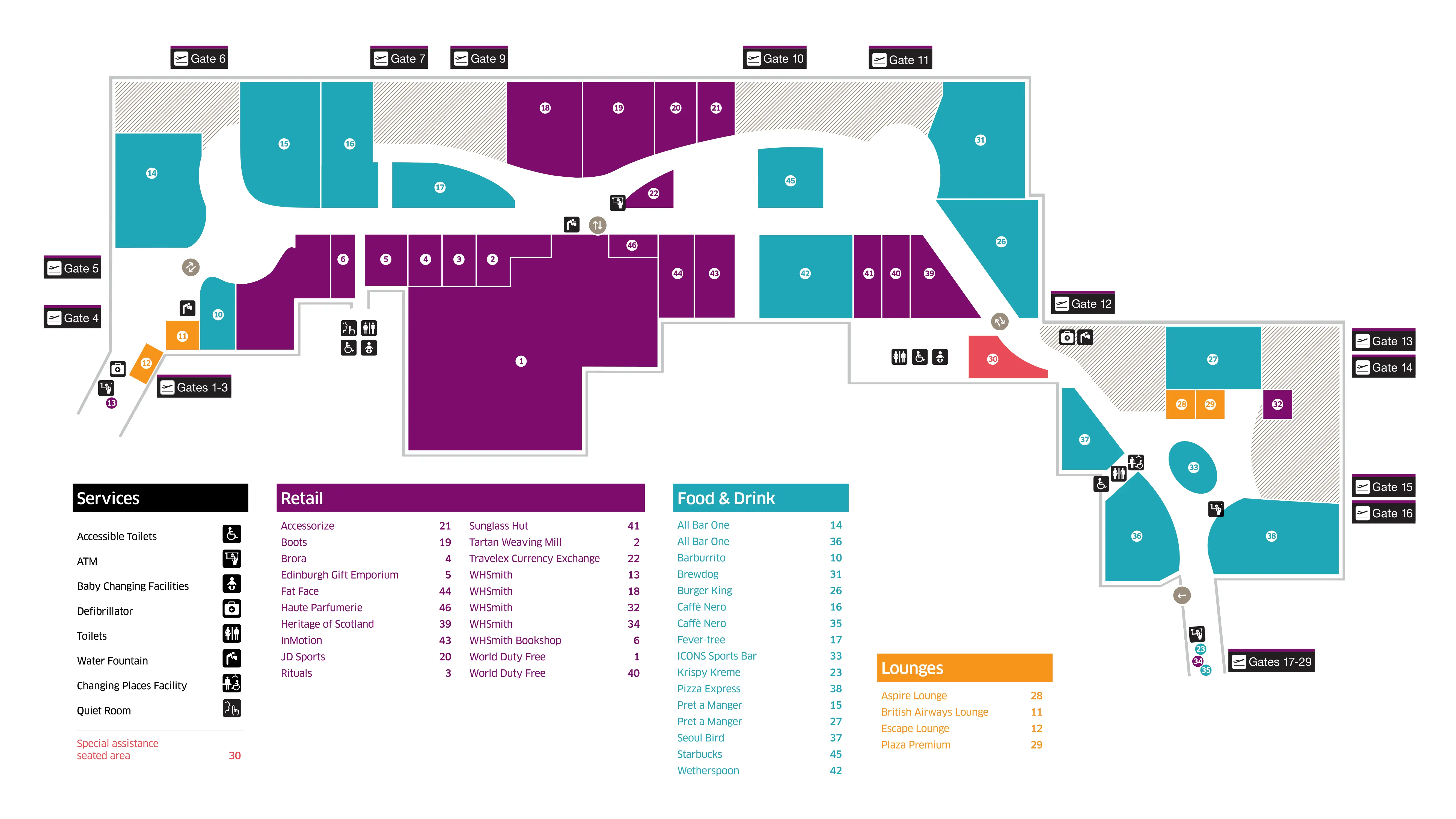
- Assume there is no reliable duty-free bypass: commit to the central aisle through World Duty Free, then re-orient at the first FIDS screen bank immediately after the exit.
- Reduce curbside chaos by picking the correct “east-side” target: Official taxi rank at East Terminus plaza, and Paid Pickup & Dropoff inside the Multi-Storey Car Park (fee pressure + wrong-level mistakes).
2026 Edinburgh Airport Map + Printable PDF
Terminal flow in 2026 still hinges on one unavoidable vertical transition into security, with the post-security route continuing through the World Duty Free funnel. The 2024/2025 check-in hall changes concentrate self-service bag drop away from the centerline, pushing Ryanair/easyJet to Zone A and Jet2 to Zone D. Expect the biggest “trapped” moments at passport control, baggage reclaim, and the duty-free exit pinch corridor.
Edinburgh Airport Before Security Map 2025
Edinburgh Airport After Security Map 2025
2026 Edinburgh Airport Map Guide
What is the exact walking route (and distance) from the tram stop to the main terminal departures entrance?
Walking takes about 100–150 meters from the Edinburgh Tram platform to the main terminal doors, using the covered East Terminus walkway into the terminal’s eastern façade. The route is direct and does not require crossing vehicle lanes.
From the tram platform, follow the signed, covered walkway across the East Terminus plaza toward the terminal building. Keep the “Edinburgh” plaza signage as your forward landmark, then continue straight into the main entrance doors on the east side. The entire walk is typically 1–2 minutes at normal pace, with weather protection most of the way.
From Arrivals, what is the exact walking route (and distance) to the official taxi rank / taxi pickup point?
Walking takes about 100 meters (around 1–2 minutes) from the Arrivals exit doors to the official taxi rank at the East Terminus plaza. The official rank is curbside on the plaza side, not inside the Multi-Storey Car Park pick-up areas.
Exit into the public Arrivals hall on the Ground Floor, then follow “Taxis” signs out through the main Arrivals doors toward the East Terminus plaza. Once outside, continue straight across the forecourt toward the curbside taxi line adjacent to the same plaza used by the tram stop (use the large “Edinburgh” sign/plaza as the visual anchor). Avoid heading into the Multi-Storey Car Park lanes, which can indicate private hire pick-up instead of the hailed-cab rank.
Where is the paid Drop-Off Zone vehicle entry located relative to the closest terminal doors (which level/side)?
The paid Pickup & Dropoff Zone is entered via the barrier-controlled entrance to the Multi-Storey Car Park on the Ground Floor, directly opposite the terminal building. The closest terminal doors are the main east-side landside doors (Arrivals/check-in level) across the forecourt.
Approaching from the A8 via Eastfield Road, stay straight through the roundabouts past the hotel cluster (Moxy/DoubleTree, then Hampton by Hilton). Continue with Terminal Parking on your left, then take the Multi-Storey Car Park entry at the barrier. Once inside, follow signs for “Paid Pickup & Dropoff” on Ground Floor; you exit on foot to the terminal via the pedestrian doors facing the terminal frontage.
What is the exact walking distance from the Drop-Off Zone pedestrian exit to the security queue entry point (including any stairs/elevators)?
Reaching the standard security queue requires a ground-floor walk into the check-in hall plus a vertical climb to First Floor security, while the fastest “short-circuit” uses the Multi-Storey Car Park Level 2 bridge directly into the security area. The paid Drop-Off pedestrian exit is about a 1-minute walk to the terminal doors, but standard security adds the escalator/elevator transition.
| Route | Walk distance | Typical time | Vertical moves | Landmark anchor |
|---|---|---|---|---|
| Standard via check-in hall | ~100–200 m + vertical transition | ~5–10 min (volume-dependent) | Up to First Floor via escalators/lifts | Terminal main doors → central hall escalators → security entry |
| Level 2 bridge “hack” | Minimal once on Level 2 | ~2–5 min (access-dependent) | Lift to MSCP Level 2 | MSCP lifts → Level 2 bridge → security/Fast Track side |
The standard path is predictable but vulnerable to the “check-in crush” and the single vertical choke point. The Level 2 bridge route bypasses most ground-floor cross-flow, but it only works if you can legitimately use the MSCP access path and reach Level 2 without being turned back.
Where are the self-service bag drop machines located relative to the main check-in hall centerline (nearest landmark/aisle)?
Self-service bag drop machines sit off the check-in hall centerline in the outer zones, concentrated far left in Zone A and far right in Zone D. The centerline area (Zones B/C) is primarily traditional desks for carriers like British Airways, KLM, Air France, and Loganair.
Entering the hall from the main doors, treat the middle as a through-aisle rather than your bag-drop target. For Ryanair and easyJet, turn hard left and follow the flow to Zone A at the far-left end of the hall. For Jet2, keep right and walk past the central aisle toward Zone D, anchored near the Starbucks area on the far-right side.
Where is the Fast Track security entrance positioned relative to the standard security queue start (left/right/behind which landmark)?
Fast Track begins to the left of the standard security flow at the top of the escalators, positioned left of the automated boarding pass scanners as you face into the security hall. The entry is marked by a dedicated archway, so you don’t join the main snake of the standard queue first.
From the check-in level, go up to First Floor security and orient on the bank of e-gates/boarding pass scanners at the front of the hall. Keep those scanners in front of you, then peel left toward the Fast Track archway rather than joining the central/right-hand standard line. If you arrive via the Multi-Storey Car Park Level 2 bridge, you effectively flank the standard queue and merge on the Fast Track side.
What is the shortest path through duty-free to reach the main departures concourse (minimizing backtracking/loops)?
There is no reliable duty-free bypass at Edinburgh Airport; the only consistently usable route runs through World Duty Free, and the fastest line is the central tiled aisle that keeps you moving without detouring into promotional bays. The “double doors” straight ahead after security are often locked or staff-only outside extreme off-hours.
After security, commit to the main aisle that runs down the middle of the store and treat it like a corridor, not a shop. Ignore the left/right end-cap displays that force S-turns, and follow the natural forward flow until the store narrows toward its exit. The moment you clear the duty-free threshold, stop only after the bottleneck to re-pack or check your phone, because the duty-free exit corridor is the terminal’s most consistent pinch point.
Where is the first reliable flight information screen bank located immediately after exiting duty-free into the concourse?
The first reliable flight information display screen (FIDS) bank is positioned immediately after the World Duty Free exit, on the departures concourse side. The screens appear right after the duty-free threshold, not inside the retail space.
Exit World Duty Free and move past the narrow release corridor that forms at the store’s mouth. Once you’re fully in the open concourse (clear of people stopping to re-pack bags), look ahead for the first clustered screen bank used for gate and status checks. Use that screen bank as your reset point before committing to either pier direction.
What is the exact walking distance from duty-free exit to the furthest gate cluster (worst-case gate walk)?
The worst-case walk to the furthest gate cluster is about 695 meters from the main processing core, which translates to roughly a 10-minute brisk walk once you’re released into the departures concourse. This “max walk” reflects the far ends of the east/west pier system rather than a single straight corridor.
From the duty-free exit, use the first open concourse as your decision point: gates spread along piers extending in two directions, and the longest walks occur when you’re assigned to the extremities (often higher-numbered gates and remote/outer pier positions). If you’re waiting near central lounge anchors like Wetherspoons or All Bar One, treat any gate at the far ends (including low-numbered gates at the opposite extreme) as a full 10-minute commitment from the core.
On the route from security/duty-free exit to gates, where is the single narrowest pinch-point corridor that causes crowding?
The single tightest pinch point is the exit corridor from World Duty Free into the main departures concourse. That corridor narrows right at the store release point, so even small pauses create a “plug” that backs people up into duty-free.
Congestion forms because everyone clears security at once, gets funneled through World Duty Free, then hits the narrow mouth where passengers stop to re-pack, check phones, or re-orient. To avoid getting trapped, keep moving until you are fully past the duty-free exit corridor and into the open concourse area near the first FIDS screen bank, then step aside at the edge before sorting bags or regrouping.
In Arrivals, where are the e-gates/self-scanners located relative to the manual passport desks (which side and how far from entry)?
The e-gates sit inside the immigration hall as a separate channel from the manual passport desks, positioned so eligible passengers can peel into the e-gate bank rather than joining the staffed-desk lines. The hall contains 15 e-gates total (10 in International Arrivals 2 and 5 in Arrivals 1).
From the arrivals corridor into immigration, follow the signs for e-gates/biometric passports and move into the dedicated e-gate lane before the manual desk queues compress. Use the desk banks as your reference: the manual desks form the longer, staffed queue lanes, while the e-gates appear as a grouped line of automated portals set apart for self-processing. If you miss the split early, you can get trapped behind the manual queue geometry.
When passport control overflows, which specific corridor/stairwell does the queue physically spill into?
When passport control overflows, the queue backs out of the immigration hall and spills into the approach corridors and stairwells that feed passengers down from the gates toward passport control. The spillback often places people standing on stairs rather than in a dedicated holding hall.
After disembarkation, the arrivals route funnels through industrial corridors into the immigration entry. When the hall hits capacity, the line reverses direction and extends back into the same corridor network you just walked—most notably the stairwell sections used for the mandatory vertical transition from the gate level to immigration. Expect limited seating and poor “escape” options once you’re in that stairwell queue, so have documents ready before you enter the immigration approach.
Where is the first baggage carousel located relative to the passport control exit doors (straight ahead/left/right; distance)?
Baggage reclaim begins immediately after you exit passport control onto the Ground Floor, with the first carousel typically encountered as you enter the reclaim hall rather than after a long corridor walk. Carousel numbering can vary by domestic vs international entry point, but the reclaim zone is one contiguous hall directly beyond the border.
From the passport control exit doors, continue forward into the baggage reclaim space and look for the first belt area you meet on entry—treat it as the “front edge” of the carousel hall. If you arrive through the international stream, you may angle slightly into the hall before the belts open up fully; use the first visible carousel number signage as your anchor rather than walking deep into the hall searching for screens.
From Arrivals, what is the exact walking route (and distance) to the Airlink 100 bus stop using the fastest exit door path?
Walking is under 50 meters from the Arrivals exit doors to the Airlink 100 at Bus Stop A, located on the East Terminus plaza immediately outside the terminal. The fastest path is the direct “Bus” exit to the forecourt, without looping through car park structures.
From the public Arrivals hall on the Ground Floor, follow “Buses” signage to the main Arrivals exit doors facing the plaza. Step outside and keep the East Terminus forecourt in front of you; Bus Stop A sits immediately along the curb line beside the plaza area marked by the large “Edinburgh” sign. The stop is adjacent to the tram zone, so if you can see the tram plaza, you’re already at the right frontage.
From Arrivals, where is the car-rental pickup point / rental shuttle stop located (exact curb/zone), and what is the walking distance to it?
Car rental pickup is at the on-airport Car Rental Centre on Jubilee Road, reached on foot via the covered walkway running alongside the Multi-Storey Car Park. No rental shuttle stop is needed because the route is walkable, typically about 3 minutes.
Exit Arrivals to the forecourt, then follow signs for “Car Rental” toward the Multi-Storey Car Park edge and join the covered pedestrian path that parallels the car park structure. Stay on that walkway until it leads you to the consolidated Car Rental Centre entrance on Jubilee Road, where the rental desks and vehicle pickup process are grouped. If you find yourself in a vehicle lane or at the paid pick-up barriers, you’ve drifted off the pedestrian route.
Where is the nearest water refill point after security, and what is the walking distance from the security exit to it?
The nearest water refill point is the bank of refill stations positioned immediately after security at the World Duty Free interface, before you commit deep into the departures concourse. The walk is very short—typically under 1 minute once you’re through the security area.
After clearing security and regaining your belongings, move forward toward the World Duty Free entrance/exit zone and look for the refill taps along the wall by the duty-free boundary. Use the duty-free threshold as your anchor: the refill bank is right there, so you can fill bottles before tackling the duty-free gauntlet or immediately after it (depending on the side the stations are on at that moment). Additional refill points exist near Gate 5 and Gate 12 areas if the main cluster is busy.