Dublin Airport Map (Most Up-To-Date)
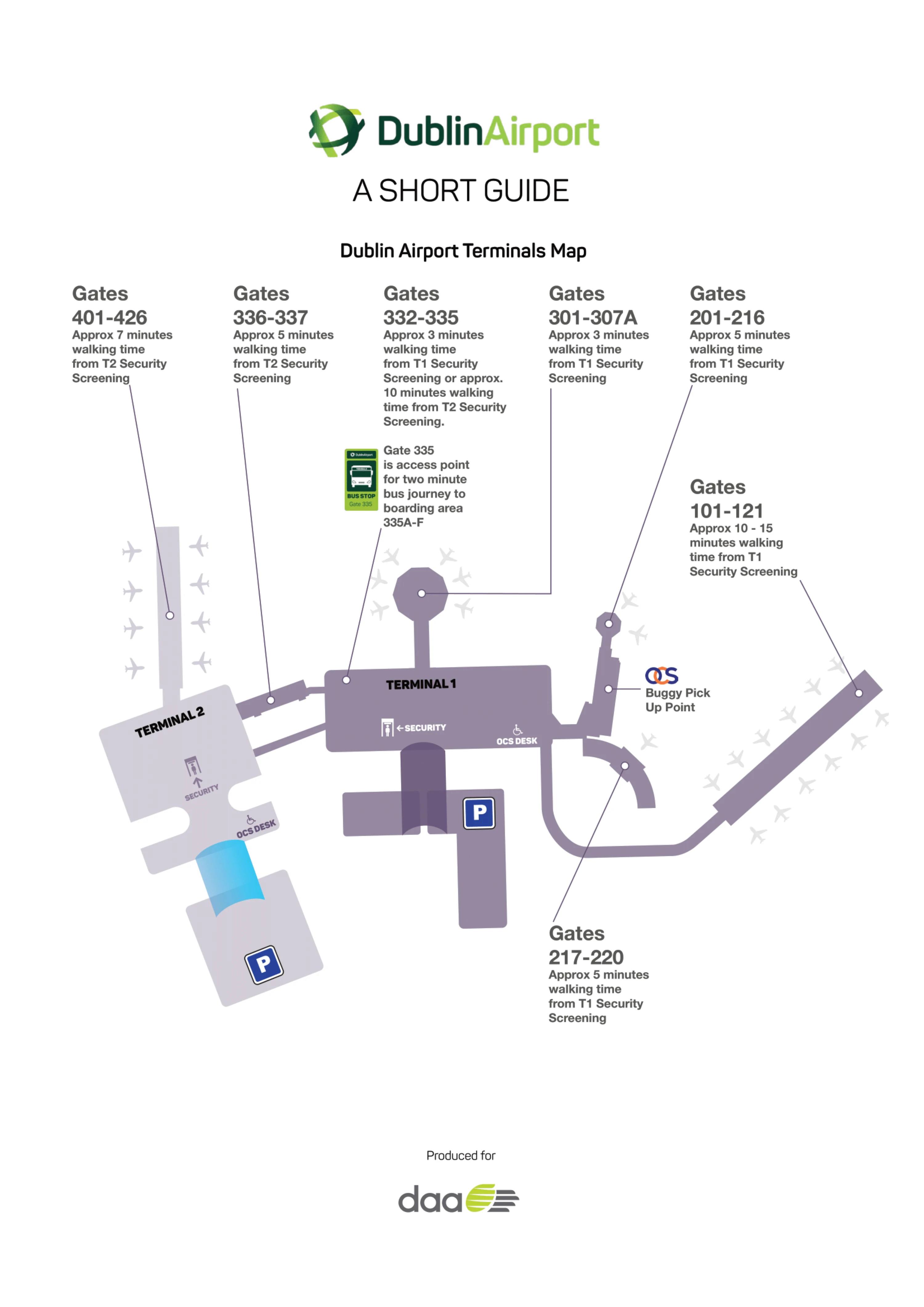
Dublin Airport’s layout is a two-terminal campus with a shared airside “spine”: Terminal 1 spreads out in long, linear piers (100–300 gates), while Terminal 2 is a newer, curved concourse focused on the 400 gates and US flights. The key junction is the link corridor between the 300s and 400s, which makes the Dublin hub feel connected airside even when it doesn’t look that way landside.
Map Table
| Terminal | Key Airlines | Primary Function | Transfer Mode |
|---|---|---|---|
| Terminal 1 | Ryanair; short-haul carriers | Short-haul departures; long-walk 100 gates | Airside walk; gate-number wayfinding (100–300) |
| Terminal 2 | Aer Lingus; transatlantic | 400 gates; US preclearance access | Airside walk; vertical escalator/lift banks |
| T1–T2 Airside Link | All transferring passengers | Link corridor between 300s and 400s | Airside corridor; ~250 m walk |
| Gate 335 / South Gates | Mixed operators (bus boarding) | Bus-gate staging; remote apron gates | Airside walk to 335; stairs down; shuttle bus |
Dublin Airport Map Strategy
- Treat gate ranges as the real navigation system: 100–300 gates typically funnel you through Terminal 1 geometry, while 400 gates pull you toward Terminal 2, even when you start in the “wrong” terminal.
- Build a walking buffer for the 100 gates and any remote/bus-gate workflow; use the central post-security hub for restrooms/seating, then commit to the pier with enough time to absorb a slow walk.
- For US flights, plan around the downstairs preclearance descent as a point-of-no-return; buy food, water, and bathroom time before you drop down into the sterile holding area.
- On landside arrivals, navigate by zones, not vibes: premium coach stops sit close to terminal exits, while hotel/off-site shuttle areas can require a longer, car-park-through walk that feels like a mini transfer.
2026 Dublin Airport Map + Printable PDF
Printable maps in 2026 are most useful when they highlight the “time traps” rather than just gate labels: the hidden T1↔T2 airside link, the extra vertical drop to US preclearance, and the long-walk 100-gate piers from the post-security retail loop. Ground transport remains zone-based, so arrivals exits and coach zones matter as much as terminals.
2026 Dublin Airport Map Guide
What is the exact airside (post-security) route entrance point that connects Terminal 1 → Terminal 2, as shown on the terminal map?
The airside Terminal 1 → Terminal 2 connection starts at the link corridor entrance between the Pier 3 (300 gates) root and the Pier 4 (400 gates) root. From Terminal 1 post-security, the practical “entry cue” on the map is following directions toward Gates 401–426, which pulls you off the main T1 retail loop and into the sterile connecting corridor.
| Mapped cue | Where you are | What to follow | Adjacent anchor point |
|---|---|---|---|
| “Gates 401–426” | T1 airside retail loop / main concourse | Turn into the link corridor | Between Pier 3 root and Pier 4 root |
| “Gates 101–307A” | T2 post-security retail atrium (Loop T2) | Back through the same corridor | Transition point before the 400-gate pier begins |
What is the exact walking distance (meters) from the main post-security duty-free atrium to the primary remote/“long-walk” Ryanair gate area on the Dublin Airport map?
Walking distance is approximately 800–900 meters from the main post-security duty-free atrium (The Loop) to the far end of the 100-series Ryanair gate pier (e.g., Gate 121). This is the primary “long-walk” zone on the map because the route bends through the retail maze, then stretches down the terminal spine into Pier 1 without moving walkways.
| Route segment | Start anchor | End anchor | Approx. distance |
|---|---|---|---|
| Duty-free release to main spine | The Loop exit | T1 main concourse spine | Retail maze segment |
| Spine to Pier 1 entrance | T1 concourse | Pier 1 (100 gates) root | Connector segment |
| Pier 1 run-out | Pier 1 root | High-number 100 gates (110–121) | Long linear pier |
| Total mapped walk | Post-security duty-free atrium | Far 100-series gates (e.g., 121) | ~800–900 m |
What is the exact walking distance (meters) from Terminal 1 Arrivals exit to Zone 11 (coach stop area beyond the multi-storey car park) on the airport forecourt map?
Walking distance is approximately 400–500 meters from the Terminal 1 Arrivals exit to Zone 11 (the coach stop area beyond the multi-storey car park). The mapped route runs from the T1 Arrivals doors across the pickup lanes, through the covered “Atrium” passage inside the multi-storey car park blocks, then out the rear toward the church-side coach park area.
| Route step | Direction cue | Adjacent anchor point | Distance impact |
|---|---|---|---|
| Exit terminal | T1 Arrivals doors | Arrivals hall curbside lanes | Start point |
| Cross forecourt lanes | Toward car park atrium | Zones 1–3 forecourt | Time loss with luggage |
| Traverse covered atrium | Through multi-storey car park | Car Park Blocks A/B “Atrium” | Main walking chunk |
| Final approach | Behind car park toward coach park | Near Airport Church (Our Lady Queen of Heaven) | Zone 11/coach area access |
| Total mapped walk | T1 Arrivals exit | Zone 11 | ~400–500 m |
Where exactly is the US preclearance entrance (downstairs access) relative to the Terminal 2 post-security exit, on the map?
The US preclearance entrance is reached by heading from the Terminal 2 post-security exit into the T2 retail loop, then continuing toward the start of the 400-gates pier to a dedicated escalator/lift bank that goes downstairs to Ground Level. On the map, it sits below the departures level, positioned under the 400-series gate zone rather than back in the main Loop T2 atrium.
From the T2 post-security retail atrium, follow signage for US flights/400 gates until you hit the vertical circulation point (escalators/elevators) near the beginning of the Pier 4 (400 gates) run. Going down is the commitment step: the downstairs preclearance access feeds into the secondary screening and CBP processing area on the ground floor “sterile” side.
Where is the bussed-gates / “south gates” staging area located relative to the main concourse on the Dublin Airport departures map?
The bussed-gates staging area is at Gate 335, positioned at the southern tip of the airside link corridor between Terminal 1 and Terminal 2. Relative to the main departures concourse, it sits off the primary spine you use to move between the 300-gate area and the 400-gate area, rather than deep in the far ends of the 100 or 400 piers.
Gate 335 functions like a bus terminal: you walk from the main concourse into the link-corridor endcap, scan your boarding pass at 335, then go downstairs to a tarmac-level holding pen for shuttle buses. The buses take you to the separate South Gates modular building (remote apron gates), so 335 is the staging choke point—not the aircraft-side boarding location.
Where is the passport/document verification desk area located in Terminal 2 check-in, on the landside map (so passengers can anticipate the extra queue point)?
The passport/document verification desk area is at the west end of the Terminal 2 check-in hall, on the right-hand side as you enter from the roadway, in the Aer Lingus check-in quadrant. On the map, it aligns with the Aer Lingus desk range (roughly desks 29–56) and sits at the head of the check-in queue lanes, before the main bag-drop flow.
The practical wayfinding anchor is “Aer Lingus check-in” rather than a standalone “verification” label: expect the extra desk point where queues form near the front of the Aer Lingus lines in that west/right-hand zone. This is the common time trap because it behaves like a pre-queue—separate from bag drop—so arriving at the wrong line can cost a full reset.
Which exact forecourt pickup/drop-off point is closest (shortest mapped walking distance) to Terminal 1 Departures doors?
Terminal 1 Short Term Car Park A is the closest legal pickup/drop-off point to the Terminal 1 doors on the forecourt map, at roughly a 150-meter walk. It functions as the nearest compliant alternative because the Terminal 1 curbside is enforced as a no-stopping zone for private vehicles.
The mapped walking path runs from the Short Term Car Park A pedestrian route into the covered atrium access toward the terminal frontage, keeping you off the red-zone curb. If you’re trying to minimize walking to the Departures doors specifically, the operational reality is the same: the closest “can actually stop here” point is the short-stay car park access rather than any curb lane directly outside the terminal.
Where exactly are the Dublin Express / city-coach stop zones located relative to Terminal 1 vs Terminal 2 arrivals exits on the airport ground transport map?
Dublin Express stops are directly outside Terminal 1 Arrivals at Zone 1, and outside Terminal 2 Arrivals at Zone 21. On the map, Terminal 1’s stop is a curbside premium position immediately at the Arrivals exit, while Terminal 2’s stop is on a dedicated transport island reached via a glass footbridge from the T2 Arrivals level, followed by an escalator descent.
| Terminal | Arrivals exit reference | Dublin Express zone | Map-anchored access cue |
|---|---|---|---|
| Terminal 1 | Ground-floor Arrivals doors | Zone 1 | Curbside immediately outside Arrivals |
| Terminal 2 | Arrivals level | Zone 21 | Cross glass footbridge to transport island, then down escalator |
What is the exact walking distance (meters) between a typical Pier/“300 gates” arrival point and the “400 gates” area used for airside connections (as mapped)?
Walking distance is approximately 250 meters between the 300-gates area (Pier 3 side) and the 400-gates area (Pier 4 side) via the airside link corridor. The map shows this as the short connector that bridges Terminal 1’s 300-gate root to Terminal 2’s 400-gate retail/pier entry zone, with the main complexity coming from level changes on the T2 side.
In practice, this is a straight, transfer-focused corridor rather than a broad concourse: you leave the 300-gates main concourse area, enter the sterile connector near the pier roots, and emerge at the 400-gates side near the start of the Pier 4 run. The walking time is often 3–5 minutes when unimpeded, but the escalator/lift bank on the T2 side can add delay if it bottlenecks.
On the map, what is the nearest restroom location to the remote/long-walk gate area that forum users complain about?
The nearest restroom block to the remote long-walk 100-series gate area is at the root of Pier 1, where the pier connector meets the main Terminal 1 concourse spine. On the map, this is the last reliable “full” restroom point before you commit down the long linear run toward higher-numbered 100 gates (110–121), where restroom availability becomes sparse and capacity-constrained.
If your boarding pass shows a far 100-series gate, the practical move is to use restrooms in the central post-security hub (around the Loop/concourse) or at the pier root, then start the walk. Once you’ve progressed deep into Pier 1, the restroom options—if shown—tend to be limited and can’t absorb multiple departures worth of passengers at the same time.
On the map, what is the nearest seating cluster to the remote/long-walk gate area (addressing “lack of seats” complaints)?
The nearest reliable seating cluster to the remote 100-series long-walk gate area is back at the main Terminal 1 post-security concourse hub around the Loop/food court zones, before you fully commit down Pier 1. On the map, Pier 1 itself shows comparatively low seating density, so the practical “seat strategy” is to stay in the central concourse seating areas until you have enough time for the long walk.
Pier 1’s seating scarcity is structural: the pier was laid out for smaller aircraft-era loads, so simultaneous departures outstrip the number of chairs available near the higher-numbered gates. If you need guaranteed seating, treat the pier as a staging run—use seating in the main concourse/food areas as your anchor, then walk to the 100 gates roughly 40 minutes before departure to avoid standing the entire time at the far end.
After US preclearance, where are the nearest food/coffee options located on the post-preclearance map area (so people don’t lose time wandering)?
Food and coffee options post-preclearance are limited to small grab-and-go and coffee kiosks in the sterile holding area, with the only substantial option being the 51st & Green Lounge at the far end of the US gates pier. On the map, the kiosks sit within the post-preclearance holding zone itself, while the lounge is deeper down the pier beyond the holding pens.
| Option type | Where it appears on the map | Closest anchor point |
|---|---|---|
| Grab-and-go kiosk | Inside the sterile post-preclearance holding area | Immediately after CBP exit into the holding zone |
| Coffee stand | Inside the same sterile holding area | Adjacent to the holding pens/seating zone |
| Full-service-style food (lounge) | Far end of the US pier | 51st & Green Lounge past the holding area |
For early/overnight situations, where are the largest landside seating areas located (before security) on the terminal map?
The largest landside seating areas are the Terminal 1 mezzanine-level food court seating zone and the Terminal 2 ground-floor seating clusters near the Oak Bar area. These are the two map-anchored “wait it out” locations because they sit outside security and have the most concentrated seating footprints compared with check-in corridors or curbside halls.
Terminal 1’s best landside seating is upstairs on the mezzanine food court level above the check-in/arrivals footprint, which is where the building geometry naturally creates a larger seating basin. Terminal 2’s most comfortable landside seating tends to be on the arrivals (ground) level around the Oak Bar zone, where soft seating clusters are grouped in a single area rather than scattered along the hall.