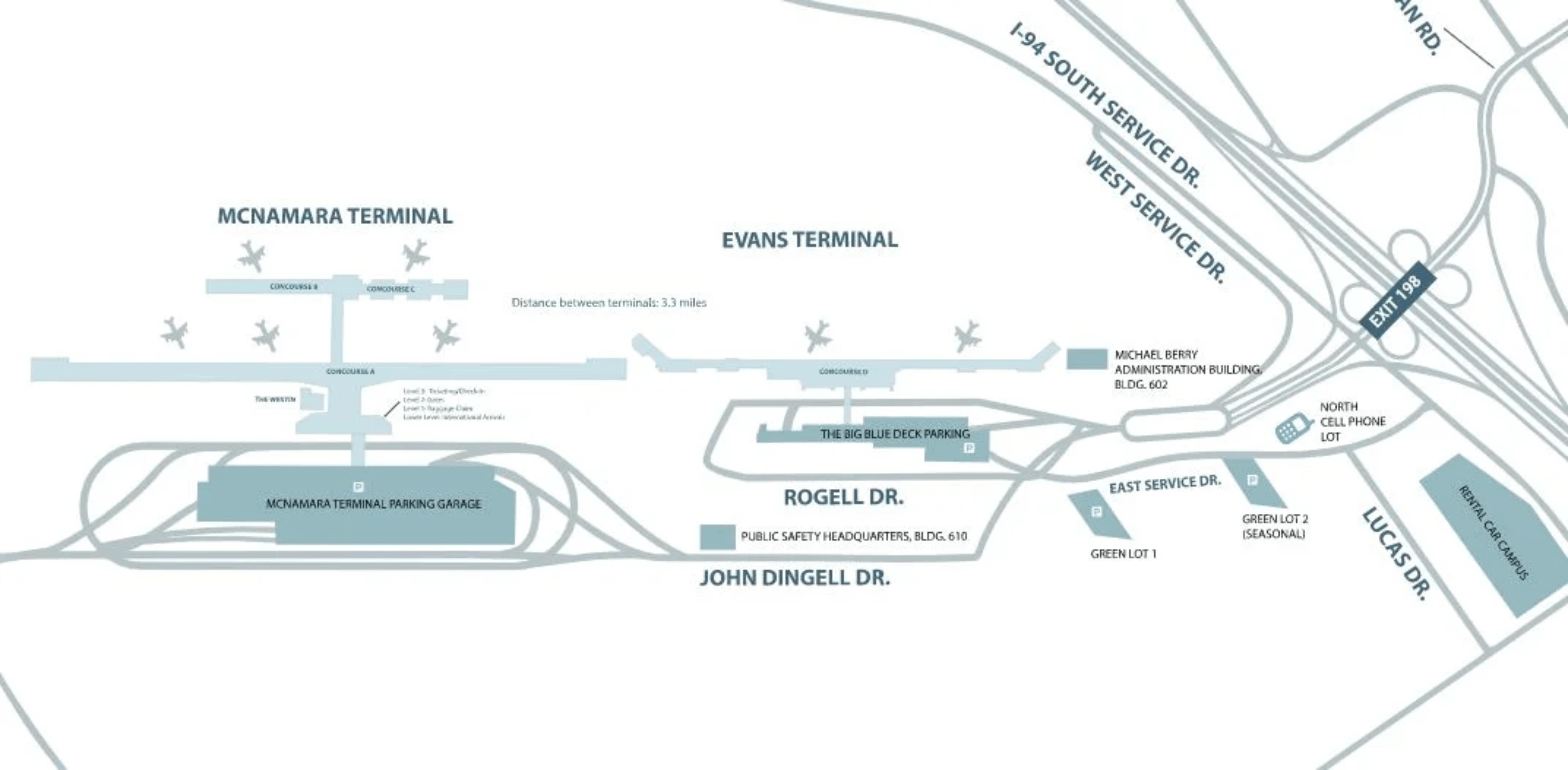
Detroit Metropolitan Airport Map (Most Up-To-Date)
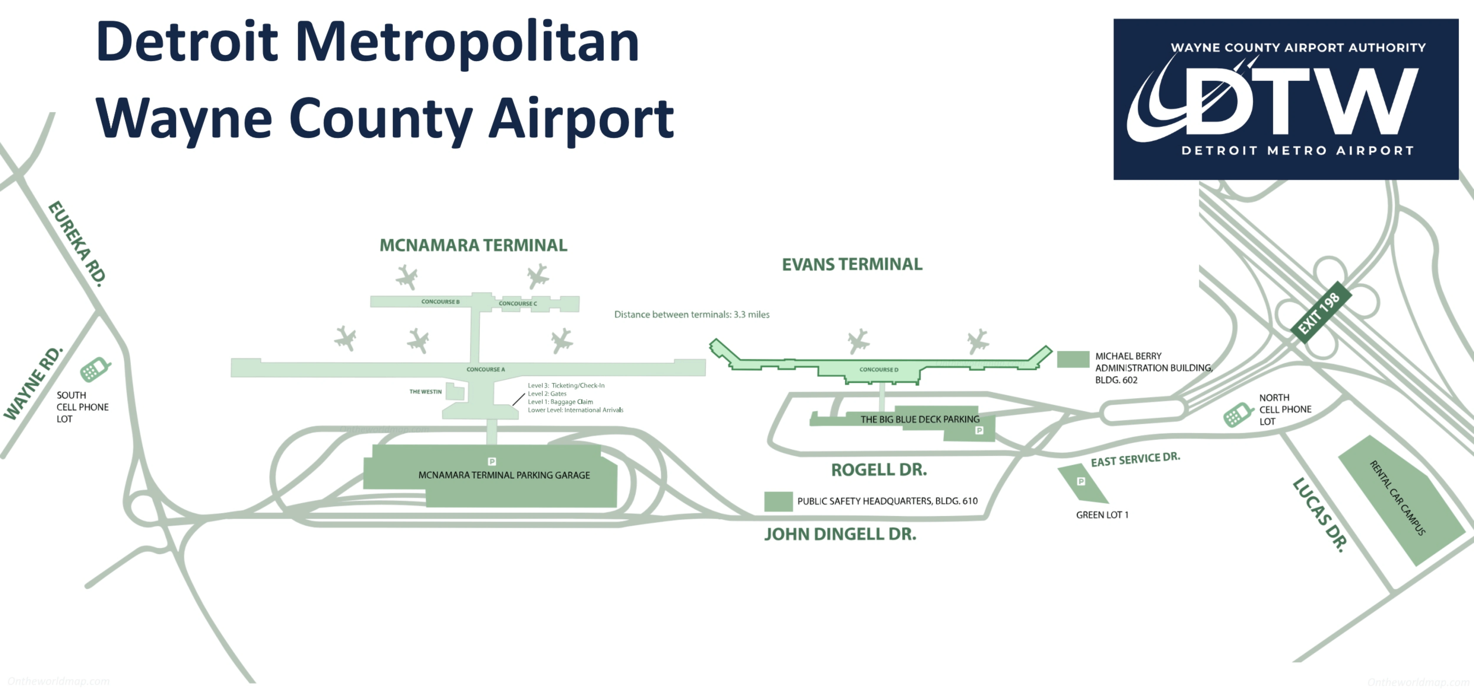
Detroit Metropolitan Airport is a two-terminal campus with one dominant, mile-long “spine” (McNamara/Concourse A) and one separate terminal (Evans/North) across the roadway loop. The McNamara complex runs in a straight north–south line with a central core near A38/A40, while Concourses B and C sit off that core via a single underground tunnel. Within the main Detroit airport grounds, your real routing choice is always walk vs ExpressTram vs landside shuttle.
Map Table
| Terminal | Key Airlines | Primary Function | Transfer Mode |
|---|---|---|---|
| McNamara (A, B, C) | Delta, Air France, KLM | Delta hub, most internationals | ExpressTram (A), Light Tunnel (A↔B/C) |
| Evans / North | Spirit, American, United | Non-Delta domestic, select international | Landside shuttle, TSA re-screen |
| Concourse A | Delta mainline | Long linear gates A1–A78 | ExpressTram, moving walkways |
| Concourses B/C | Delta Connection | Regional gates B1–B21, C1–C27 | Single tunnel to A core |
Detroit Metropolitan Airport Map Strategy
- Treat the A↔B/C tunnel as a fixed choke point: one portal at the A38/A40 core, one portal at the B/C hub, plus escalators on both ends that add time even when the corridor is clear.
- Use ExpressTram only when you’re crossing a big chunk of Concourse A; for mid-range moves near the center core, walking usually wins because escalators + platform access + wait time can erase the tram advantage.
- Plan McNamara↔Evans/North as a landside transfer every time: exit security, take the terminal-to-terminal shuttle, then re-clear TSA—no airside workaround.
- If you’re arriving by shuttle or calling a ride, lock onto the Ground Transportation Center and garage Level 4 logic early; “wrong level” errors (curbside vs garage) are the fastest way to lose minutes.
2025 Detroit Metropolitan Airport Map + Printable PDF
Detroit’s layout in 2026 is still defined by the McNamara “long straight line” and the hard split from Evans/North. The ExpressTram (three stations) and the A↔B/C tunnel remain the make-or-break connectors for tight Delta itineraries, while any McNamara↔Evans/North self-transfer stays landside with a shuttle and full re-screening. Expect secondary friction around overflow parking and the garage-based rideshare pickup.
2026 Detroit Metropolitan Airport Map Guide
What is the exact walking distance (feet/meters) through the B/C ↔ A tunnel from the down-escalator entry to the up-escalator exit?
The B/C ↔ A tunnel distance is 700 feet (213.36 meters) from the down-escalator entry to the up-escalator exit. That measurement covers the straight corridor segment between the escalator bases, not the extra time you spend descending/ascending or merging onto the moving walkways.
The tunnel portals sit at the McNamara center core between Gates A38 and A40 on the Concourse A side, and at the B/C hub where you split left to Concourse B or right to Concourse C. Two moving walkways run each direction, so your corridor time can drop to roughly 80–90 seconds if you walk on the belt, but the fixed distance remains 700 feet.
From the Concourse A tunnel exit, what is the exact distance to the nearest ExpressTram platform entrance (base of escalators)?
The nearest ExpressTram platform access is about 50–75 feet (15–23 meters) from the Concourse A tunnel exit. That short gap is intentional because the tunnel emerges into the same central core plaza as the ExpressTram “Terminal Station” escalators.
Coming up from the tunnel between Gates A38 and A40, you step into the Water Feature / center-core area. The ExpressTram escalators are immediately adjacent in that atrium, so the distance is essentially the few steps from the tunnel escalator landing to the base of the tram-station escalators—typically under 30 seconds unless the area is congested.
In McNamara Terminal, what is the exact physical pickup point (door/level/zone) for the terminal-to-terminal shuttle to Evans/North?
The terminal-to-terminal shuttle pickup is at the Ground Transportation Center in the McNamara parking garage on Level 4. That’s not the curb at Arrivals or Departures, so going to the wrong door level is the common failure mode.
From the McNamara terminal interior, follow Ground Transportation / Shuttle signage toward the pedestrian bridge into the garage (the same bridge system used for garage access). After you enter the garage side, use the elevator bank down to Level 4 and look for the dedicated shuttle bays in the Ground Transportation Center zone. The bus stop is positioned as a “shuttle stall” area inside the garage structure, not out on the terminal roadway curb.
In Evans/North Terminal, what is the exact drop-off point (door/level/zone) where the terminal-to-terminal shuttle unloads passengers?
The terminal-to-terminal shuttle unloads at the Ground Transportation Center connected to the Evans/North Terminal, not at the main departures/arrivals curb. The practical “zone” is the GTC area by the Big Blue Deck complex where commercial shuttles stage.
After you get off, you enter the Ground Transportation Center building and use the skybridge connection to reach the terminal’s ticketing/security level. That skybridge/elevator step is the built-in time penalty that catches people off guard, so plan on a few extra minutes between stepping off the bus and reaching the terminal interior.
When McNamara parking is full and a traveler uses Big Blue Deck + shuttle, what is the shortest mapped walking route from the shuttle drop-off to the nearest security checkpoint entrance?
The shortest route uses the Level 2 bridge security checkpoint immediately at the end of the McNamara skybridge. Starting from the McNamara shuttle drop-off in the Ground Transportation Center on garage Level 4, this path avoids going up to the main ticketing hall unless you need it.
| Step | Fastest path from shuttle drop-off | Landmark cue |
|---|---|---|
| 1 | Exit shuttle at McNamara Ground Transportation Center, garage Level 4 | Shuttle bays inside the garage |
| 2 | Take the garage elevator to Level 6 (skybridge level) | Elevator bank beside Ground Transportation Center |
| 3 | Cross the pedestrian bridge into the terminal (arrive terminal Level 2) | Bridge moving walkway toward McNamara |
| 4 | Enter the Level 2 bridge checkpoint immediately at the end of the bridge | TSA entry right at the bridge landing |
From McNamara baggage claim, what is the exact mapped route (turn-by-turn landmarks) to the designated rideshare pickup zone?
The designated rideshare pickup zone is inside the McNamara parking garage on Level 4 at the Ground Transportation Center area. Waiting at the Level 1 arrivals curb is the classic mistake because rideshare pickups are garage-controlled rather than curbside.
From baggage claim on Level 1, go to the central escalators/elevators and ride up to Level 2 (the bridge level). Follow overhead signs for Ground Transportation and Parking and cross the pedestrian skybridge into the parking garage (you’ll be on garage Level 6 at the bridge entry). Immediately find the nearby elevator bank and go down to garage Level 4, then follow the Rideshare / Uber / Lyft signs within the Ground Transportation Center zone to the marked pickup area.
For Gate A70–A78, which ExpressTram station is the nearest by walking distance, and what is that distance?
North Station is the nearest ExpressTram station for Gates A70–A78, about 400–500 feet (120–150 meters) away on foot. The closest access point is the North Station escalator bank positioned around the A68/A70 area.
From Gate A78, walk “down-number” toward Gate A70 until you reach the ExpressTram North Station signage and the station escalators near Gate A68/A70. That span is roughly five gate frontages, which is why it typically clocks as a 1.5–2 minute walk at a brisk pace. For anything headed toward the center core (A38/A40) or the low-A gates, North Station is the only mechanized shortcut that avoids the long straight walk.
From the tunnel exit point in Concourse A (between the mid-gates), what is the exact walking distance to Gate A8 using the fastest airside path?
The tunnel exit to Gate A8 is approximately 1,800–2,000 feet (550–600 meters) by the fastest airside path. The tunnel arrives in the McNamara center core between Gates A38 and A40, and Gate A8 sits deep in the low-numbered “South” end of Concourse A.
Walking is the lowest-variance route: exit the tunnel into the Water Feature / center-core area, turn toward the lower-numbered gates, and stay on the main concourse corridor heading south until you reach Gate A8. Using the ExpressTram can beat walking only if the train is immediately available at the Terminal Station; otherwise, escalators + wait time can erase the advantage, since the South Station drops you around the A15–A20 area and still leaves a short walk down to A8.
Where is the Westin-connected TSA entry located relative to Gate A36, and what is the exact walking distance between them?
The Westin-connected TSA entry exits directly across from Gate A36, under 50 feet (about 15 meters) away. The checkpoint injects you into Concourse A at the A36 area rather than at the A38/A40 center core.
Once you clear that checkpoint, Gate A36 is essentially a straight “cross-the-concourse” move: you emerge at the concourse wall and the A36 holdroom is immediately opposite. This is why it functions as a tactical bypass when the center-core security area around the Water Feature is congested—your airside entry point is already in the mid-gates without the center-core crowd.
At Evans/North Terminal, where is the rental car shuttle pickup curb/stop, and what is the walking distance from baggage claim to that pickup point?
The rental car shuttle pickup is at the Evans/North Ground Transportation Center by the Big Blue Deck, roughly 800–1,000 feet (about 240–305 meters) from baggage claim when you include the vertical moves and skybridge. The stop is not at the immediate curb outside baggage claim; it’s staged in the Ground Transportation Center lanes.
From Evans/North baggage claim, go up to the skybridge level and follow Ground Transportation signage toward the connection to the Big Blue Deck/GTC. Cross the bridge into the Ground Transportation Center area, then descend to the commercial shuttle staging level where the rental car buses load. The distance feels longer than it looks on a map because the bridge and level changes add time even though the straight-line footprint is compact.
In McNamara Terminal (landside), what is the shortest mapped walking path from the terminal-to-terminal shuttle arrival door to the Delta check-in row?
The shortest path is via the McNamara Ground Transportation Center arrival on garage Level 4, then up to the skybridge and into the ticketing lobby for Delta check-in. That route is about 600 feet of walking plus two vertical transitions.
Exit the terminal-to-terminal shuttle at the Ground Transportation Center (garage Level 4) and go to the nearby elevator bank. Ride up to garage Level 6 (the pedestrian bridge level) and cross the skybridge into the terminal (terminal Level 2). Once inside, take the escalator or elevator up one level to the ticketing lobby (terminal Level 3), where the Delta check-in rows dominate the hall straight ahead and along the main counter line.
In McNamara Concourse A, where is Minute Suites (near A66) located on the map, and what is the walking distance from Gate A66 to its entrance?
Minute Suites is located in the North zone of McNamara Concourse A near Gate A66, within about 100 feet (30 meters) of Gate A66. The entrance sits directly off the main concourse corridor by the A66 holdroom area rather than in a remote side hallway.
From Gate A66, step out to the main retail/concourse spine and follow the immediate “Minute Suites” signage in the same gate cluster. It’s close enough that the walk is typically under a minute, and it’s also within easy reach of the ExpressTram North Station area serving the A56–A78 zone.
Archive Detroit Metropolitan Airport Map
Below are all historical map versions for Detroit Metropolitan Airport. Each year includes the official map available for that period, presented as both WebP and PDF.
2022 Detroit Metropolitan Airport Map