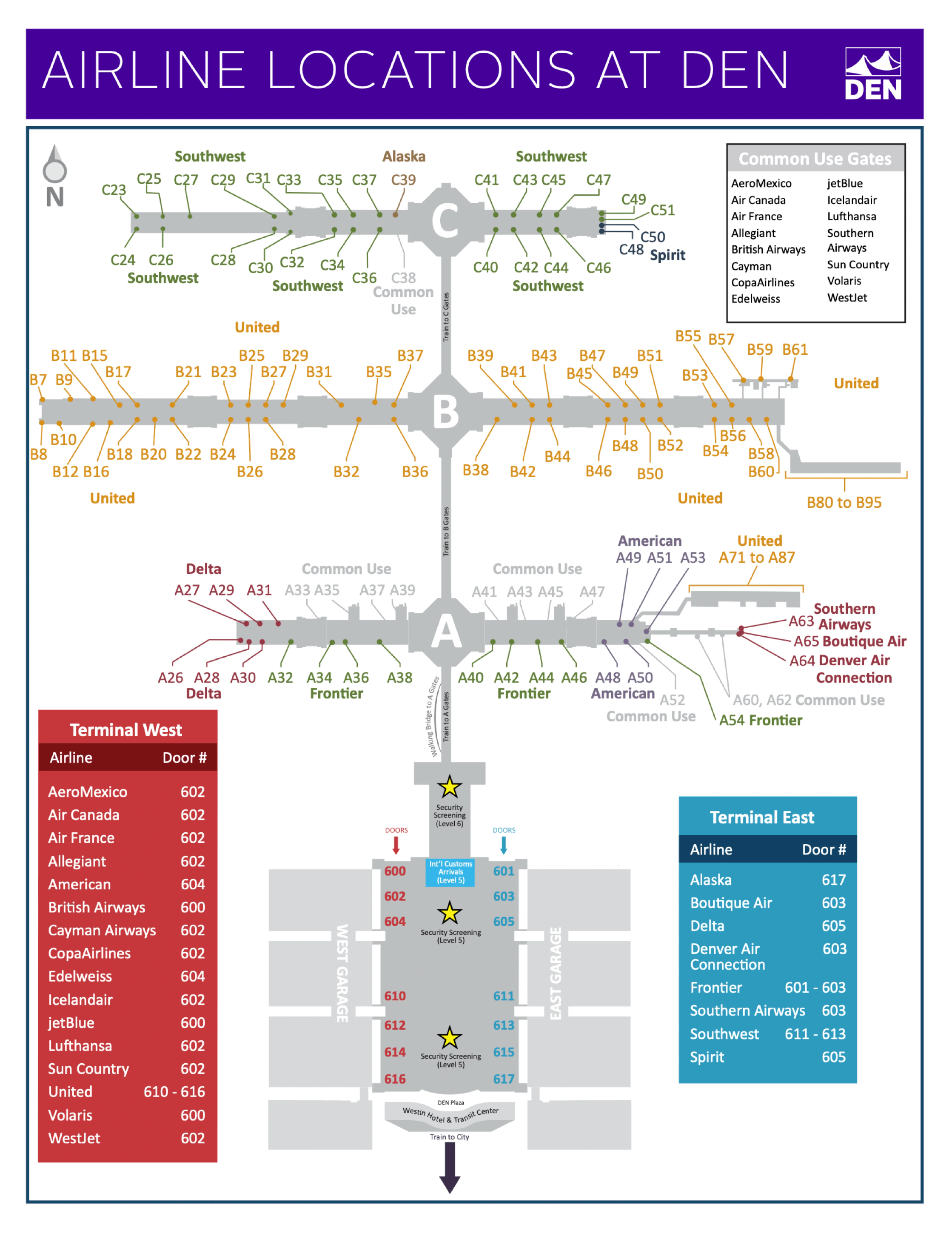
Denver International Airport Map (Most Up-To-Date)
Denver International Airport (DEN) runs like a “dumbbell”: one centralized landside terminal (Jeppesen Terminal) feeding three long, linear concourses (A, B, C). The footprint is huge (DEN spans ~53 square miles), but passenger flow compresses into two tight choke nodes—security on the upper levels and the underground concourse train. Inside the Denver hub airport complex, navigation is mostly about picking the right side (East vs West), the right level (4/5/6), and the right post-security path.
Map Table
| Terminal | Key Airlines | Primary Function | Transfer Mode |
|---|---|---|---|
| Jeppesen Terminal | United dominant (West) · Southwest/Frontier/Delta (East) | Check-in · Security · Baggage claim · Ground transport | AGTS train to A/B/C · Concourse A bridge |
| Concourse A | International arrivals focus · mixed carriers | Gates A · CBP/Customs processing | AGTS train · Pedestrian bridge |
| Concourse B | United | Gates B | AGTS train only |
| Concourse C | Southwest | Gates C | AGTS train only |
Denver International Airport Map Strategy
- Commit to a checkpoint at the Level 6 atrium decision zone (near the tent apex): West Security aligns with United (Doors 600–606 area), while South Security is a Level 5 fallback with different crowd dynamics.
- Treat lane choice like a second fork inside West Security: PreCheck/CLEAR intake near Doors 600/602, standard intake closer to Door 606; entering the wrong intake means fighting barriers and backflow.
- Assume queue geography can back up toward baggage claim on peak mornings: lock your level first (Departures/Check-in/Security on Level 6) so you don’t waste time hunting on Level 5.
- Train failure changes what’s possible: Concourse A has a walkable pedestrian bridge; Concourses B and C have no walkable route—don’t clear security expecting to walk to B/C if the AGTS is down.
2026 Denver International Airport Map + Printable PDF
In 2026, DEN’s wayfinding still centers on Great Hall construction impacts and the newer Level 6 security pattern: West Security is the primary high-throughput entry, while the East-side buildout continues to reshape approaches from the curbside doors. The most important “map reality” is that security choice and the concourse train are tightly coupled—when either bogs down, crowding stacks fast across levels and escalators.
Denver International Airport Airlines Location Map 2025
Denver International Airport Overview Map 2025

2026 Denver International Airport Map Guide
What is the exact physical fork point (landmark + level) where travelers must commit to one security checkpoint path versus the other in Jeppesen Terminal?
The commit point is Jeppesen Terminal Level 6 at the north edge of the central atrium, near the tent apex where construction walls stop straight-line walking and force a left/right choice. From that Level 6 atrium “decision zone,” the West Security path pulls you northwest toward the United ticketing lobby (Doors 600–606 area), while the South Security path pulls you south into the Great Hall core.
| Route choice | Exact fork landmark | Commitment direction | What makes it “locked in” |
|---|---|---|---|
| West Security | Level 6 · North atrium edge · near the tent apex facing United ticketing | Northwest toward United check-in | Queue corridors + barriers block easy crossover once you enter |
| South Security | Level 6 · Same atrium decision zone, turning away from United | South toward Great Hall core, then down to Level 5 | Level change + construction walls make backtracking slow and confusing |
Which security checkpoint entrance is geographically closest to the United check-in counters (shortest walking path)?
The West Security Checkpoint on Level 6 is the closest checkpoint to the United ticketing lobby. United’s main check-in footprint sits on the northwest side of Jeppesen Terminal, and West Security is built immediately adjacent to that area, minimizing the walk from the United counters to the document-check/podium zone.
If you’re standing at United check-in on Level 6, you should be oriented northwest into West Security rather than drifting toward the Great Hall core. The practical mistake is heading inward and south, which steers you toward the legacy South Security flow on Level 5. Within West Security, the nearest intake to the United counters is the south-side intake near Door 606 (standard screening), while the PreCheck/CLEAR intake requires walking farther north toward Doors 600/602.
What is the exact walking distance from the security exit to the first escalator down to the concourse train platform?
The walking distance is about 50–100 feet (15–30 meters) from the security exit to the first escalator bank down to the concourse train. From the West Security exit, the re-combobulation area funnels straight toward the “triple escalator” bank, and the escalators are visible immediately ahead on a direct line of sight.
The key landmark is the post-screening mixing/repack zone immediately after the X-ray belt exits: once you step clear of the belt area, you’re essentially already at the escalator threshold. The most common slowdown isn’t navigation—it’s crowd-stacking at the escalator mouth when queues surge or when a train disruption pushes people back up the vertical circulation.
If the concourse train is not operating, what is the closest walkable alternative route (if any) from Jeppesen Terminal to Concourse A?
The Concourse A Pedestrian Bridge is the only walkable alternative from Jeppesen Terminal when the concourse train is down. The bridge access is at the north end of Jeppesen Terminal on Level 6, and it connects directly to Concourse A only.
There is no walkable route to Concourses B or C under any normal operating condition. If the AGTS is not operating, B and C passengers are dependent on an emergency bus bridge that is slow to deploy and limited in capacity, so clearing security without a confirmed plan can strand you in the sterile area. For A gates, the bridge is the fail-safe: you can reach it either by using Bridge Security (Level 6 north) or by walking north post-security toward the bridge entrance.
Which baggage claim carousel cluster is closest (shortest walk) to the primary rideshare/ground-transport elevator bank?
The shortest walk to rideshare does not use an elevator bank at all, because rideshare pickup is on the same level as baggage claim (Level 5). The closest “cluster” is the set of carousels nearest the Level 5 exterior doors you’ll use to walk straight out to Island 5.
On the West side, Carousels 10–15 sit most centrally to the common West exits (Doors 506–512). On the East side, Carousels 1–5 sit most centrally to the common East exits (Doors 507–513). If you instead mean the vertical core down to the Transit Center (A Line), the closest carousels are the more south-adjacent ones near the South Atrium (East: around Carousel 9; West: around Carousels 10/11), aligned with the long escalators near the Westin Hotel visual anchor.
From the Pikes Peak shuttle drop-off point, what is the shortest indoor walking route to the security level escalators?
The shortest indoor route starts by entering Jeppesen Terminal from Level 5 East at Door 511 or Door 513, then walking straight west into the terminal core to the main escalator/elevator banks that go up to Level 6. From the Pikes Peak drop-off on Island 3, this is the fastest way to correct the level mismatch (Arrivals level to Departures/Security level).
After you ride up to Level 6, continue northwest across the atrium toward West Security by orienting toward the United ticketing lobby. The key landmark is the central core vertical circulation near baggage claim/atrium; the common wrong-path is staying on Level 5 looking for “security,” which steers you into the legacy South Security footprint instead of the higher-throughput Level 6 West Security flow.
From baggage claim, what is the shortest indoor route to the designated rideshare pickup doors (including the correct elevator/escalator bank)?
The shortest route is a flat Level 5 walk straight from your carousel to the nearest exterior door, because rideshare pickup is curbside on Level 5 and does not require any elevator or escalator. From baggage claim, follow the “Ground Transportation / Rideshare” signs to the closest Level 5 exit door on your side of the terminal.
After you exit, cross the islands in order to reach rideshare: pass Island 1 (taxis), Island 2 (limos), Island 3 (shuttles), Island 4 (rental car shuttles), then arrive at Island 5 (Uber/Lyft geofenced pickup). Typical direct doors are Door 506 on the West side or Door 511 on the East side, but the fastest choice is simply the closest Level 5 door to your carousel—vertical moves only add distance unless you mistakenly went to Level 4 or Level 6.
Where exactly is the rental car shuttle/bus pickup zone relative to baggage claim doors (closest door number/exit)?
The rental car shuttle pickup zone is on Level 5 at Island 4, directly outside the baggage claim level doors. The closest exits are the door numbers that open nearest Island 4 on each side of Jeppesen Terminal.
| Terminal side | Closest Level 5 doors to Rental Car shuttles | Pickup location |
|---|---|---|
| West | Doors 504 · 506 · 510 · 512 | Island 4 |
| East | Doors 505 · 507 · 511 · 513 | Island 4 |
Exit baggage claim on Level 5 through one of those doors, cross the traffic islands from the curb, and wait on Island 4. If you find yourself on Island 5, you’ve gone one island too far into rideshare.
Which terminal doors provide the most direct pedestrian access to the RTD A Line station bridge/entrance?
The most direct access uses the south end of Jeppesen Terminal, where the main escalator/elevator complex drops down to the Transit Center. From Level 5, walk south toward the large glass wall and the Westin Hotel plaza landmark, then take the long, prominent escalators down to Level 1 for the RTD A Line station connection.
Door numbers vary by side and shift with curb operations, so the dependable map anchor is the South Atrium/Westin Hotel sightline rather than a single curb door. If you exit Level 5 near the south-center core and then re-enter at the south end, you’ll be aligned with the Transit Center vertical path; exiting far north on Level 5 adds a long interior backtrack before you can descend.
After international arrivals processing (Concourse A), where is the exact bag recheck drop location (relative to exits/elevators) before re-clearing security?
The bag recheck drop is immediately outside the Customs Hall exit doors on Jeppesen Terminal Level 5 North, positioned straight ahead and slightly to the right as you step into the reception lobby. It sits before you merge into the public greeting area, so you should see the recheck counter almost as soon as the opaque exit doors open.
If you walk past that counter line and drift into the main meet-and-greet crowd near the glass doors, you’ve gone too far and you cannot easily reverse without hauling bags through public areas. The reliable landmark is the Customs exit itself: treat the recheck desk as the first service point after CBP, not something deeper in the terminal, and recheck before you start looking for elevators/escalators back up toward Level 6 security.
What is the walking distance from the farthest gate area on Concourse C to the concourse train platform entrance?
The walking distance is about 1,600–1,700 feet (roughly 0.3 miles) from the far end of Concourse C to the train platform entrance at the center core. Using Gate C67 as the farthest anchor point, that distance is a roughly straight, linear walk back to the concourse train node.
At an uninterrupted 3 mph pace, the walk is around 6 minutes, but real-world conditions (crowds, luggage drag, occasional moving walkway downtime) make 10–12 minutes a safer budget. The landmark to aim for is the concourse “center core” where the AGTS station and vertical circulation sit; once you see the central retail cluster and the station approach, you’re effectively at the platform entrance.
Which specific pedestrian corridor(s) between check-in and security are blocked or detoured by Great Hall construction (as shown on the terminal map)?
The blocked route is the Level 6 East curbside/window-line corridor, which is closed through the north stretch between Doors 601 and 605. This closure prevents a clean, straight internal walk along the outer edge from far-north East curb drop-offs toward the center core and north-side pathways.
The practical effect is that East-side passengers dropped near the north end can’t simply “hug the glass” toward security; they have to cut inward around construction walls and through check-in circulation, which adds time and creates counterflow. If you’re trying to reach Level 6 security from East check-in, the reliable move is to navigate inward early toward the atrium/core rather than expecting an uninterrupted curbside corridor.
What is the exact entry point (level + location) to the garage-to-terminal connector tunnel/bridge used by parked travelers?
The garage-to-terminal connector enters Jeppesen Terminal on Level 4 (Arrivals) via the enclosed pedestrian bridges from the East and West garages. Even if you park on a different garage level, the bridge interface itself is anchored to Level 4.
The key landmark is the climate-controlled bridge landing into the terminal’s Arrivals level: you cross into Terminal Level 4 and then must move vertically up to Level 6 for check-in/security. The common wrong-path is searching for the connector on Level 5 near baggage claim—once you’re on Level 5, you’ve already passed the bridge entry level and need to correct back to the Level 4 connection zone or use the terminal’s central vertical banks to climb to Level 6.
Inside the security checkpoint footprint, where is the precise entrance split between PreCheck and standard lanes (map-identifiable decision point)?
The split is at West Security on Level 6, where the north intake near Doors 600/602 feeds TSA PreCheck and CLEAR while the south intake near Door 606 feeds standard screening. The decision point is the moment you enter the West Security queue corridor: choosing the wrong end locks you into the wrong intake because barriers channel people forward and block easy lateral crossover.
If you are coming from United check-in, the closest intake you’ll see is the standard-side entrance near Door 606, but PreCheck/CLEAR requires continuing farther north along the checkpoint frontage toward Doors 600/602. The reliable landmark is the door numbering: lower 600/602 = north end (PreCheck/CLEAR), higher 606 = south end (standard).