Dayton International Airport Map (Most Up-To-Date)
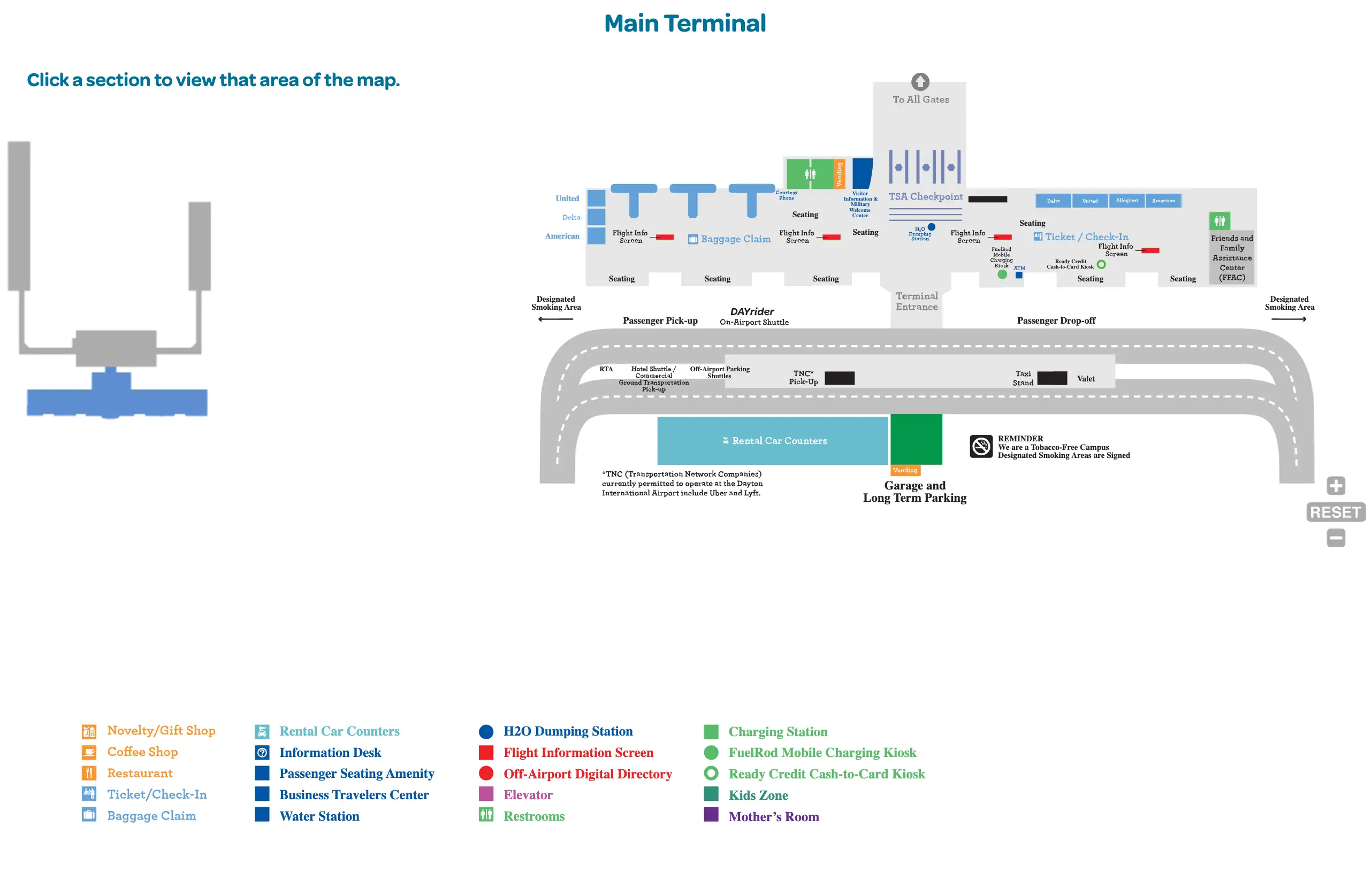
Dayton International Airport (DAY) is a compact, single-terminal airport with one central public hall that splits into two concourses (A and B) behind a single TSA checkpoint. The landside layout runs along Terminal Drive, with parking tiers (Garage, Short Term, Long Term, Economy) spreading outward. Most time loss happens at the curb, in the Economy Lot, or at the checkpoint entrance within the Dayton hub.
Map Table
| Terminal | Key Airlines | Primary Function | Transfer Mode |
|---|---|---|---|
| Main Terminal (single building) | American, Delta, United, Southwest, Allegiant | Ticketing, baggage claim, security | Walk, shuttle, curb |
| Concourse A | Major carriers mix | Gates, jet bridges | Post-security walk |
| Concourse B | Major carriers mix | Gates, jet bridges | Post-security walk |
| Economy Lot | — | Budget parking | Walk, DAYrider shuttle |
Dayton International Airport Map Strategy
- Park for the shortest walk by driving past the “false full” entrance area in Economy; the closest practical Economy zone is the far end with a direct, line-of-sight walk to the terminal doors (about 500 ft).
- Treat the pre-5:00am checkpoint line as a staging event: the line forms at the closed TSA stanchions and then snakes back toward ticketing/USO-adjacent space, so go directly to the checkpoint area instead of hovering in the lobby.
- Use the islands and doors as your ground-transport compass: rideshare pickup is not at the main curb—cross the first crosswalk from baggage claim to the 1st island; taxis are fastest via the “Limousine and Taxi” door by Baggage Carousel #3.
- Resolve parking payment risk before you leave your car: Metropolis is scan-first and exit-lane-light—scan a “Scan to Park” QR sign in the lot, because automated exits don’t work like pay-at-exit kiosks and can force a detour to a staffed cashier lane.
2026 Dayton International Airport Map + Printable PDF
Current terminal access patterns at DAY still hinge on time-based choke points: the single checkpoint can stage a long pre-open line, while curbside entry and ticketing-side access can be affected by lane/door constraints tied to modernization work. For printing, prioritize a map that shows the Economy Lot far-end walk line, the checkpoint stanchion area, and the ground-transport islands across from baggage claim.
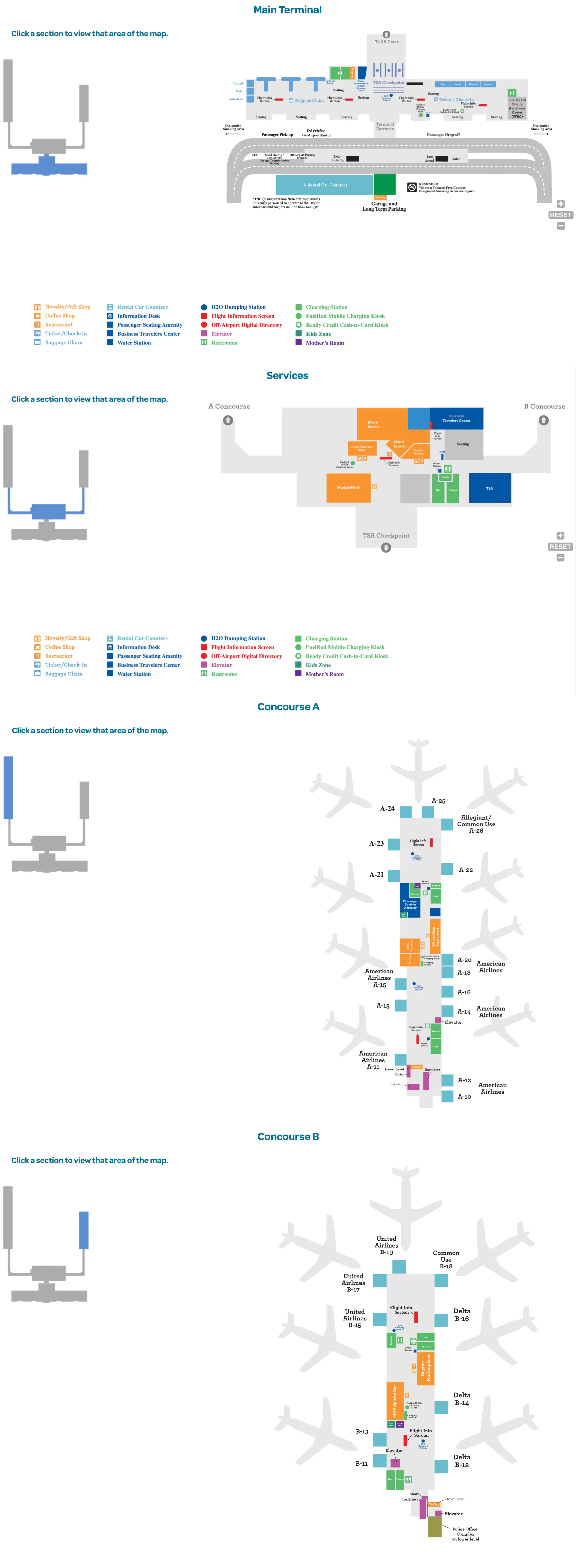
Dayton International Airport Main Terminal Map 2026
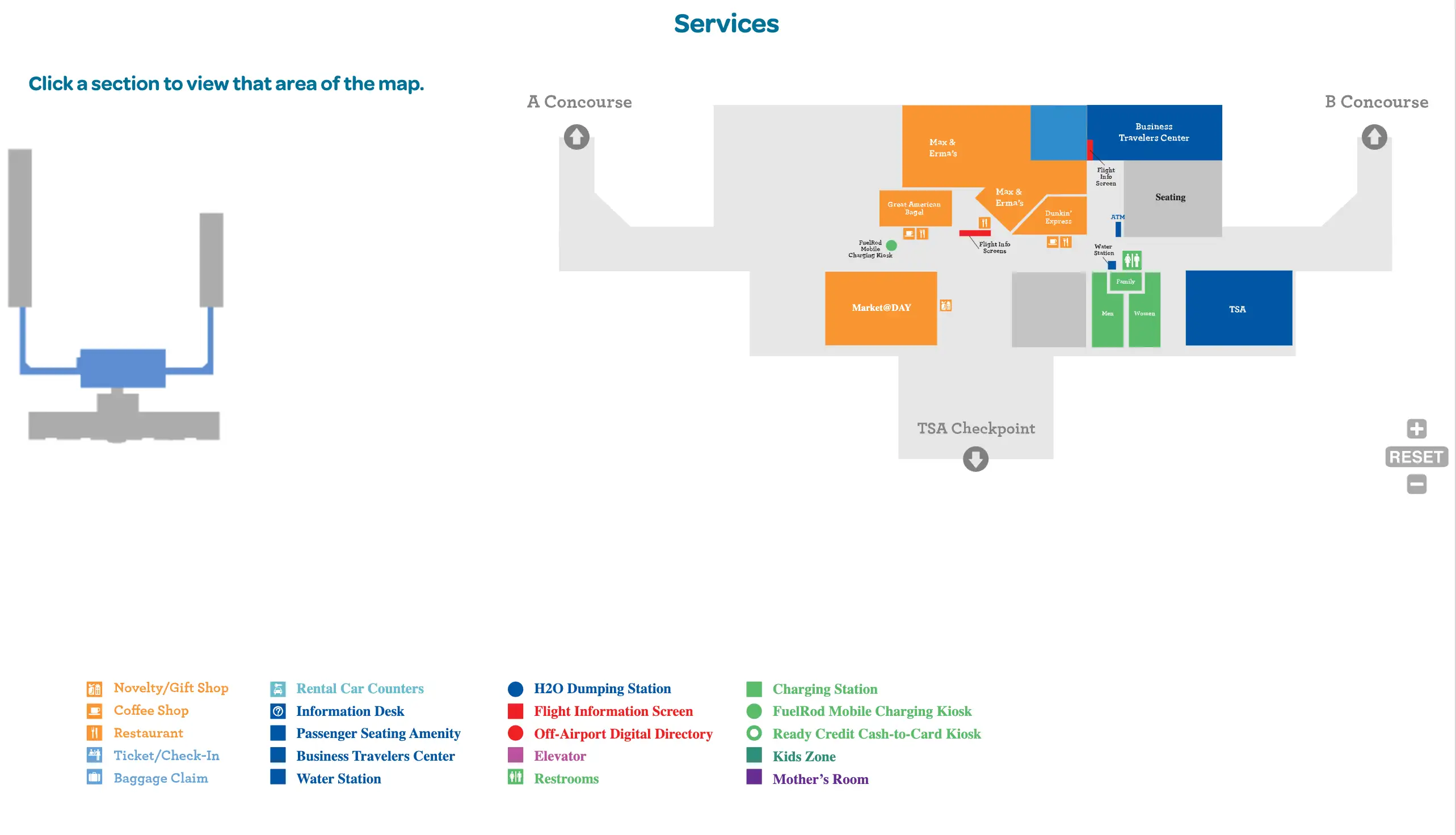
Dayton International Airport Services Map 2026
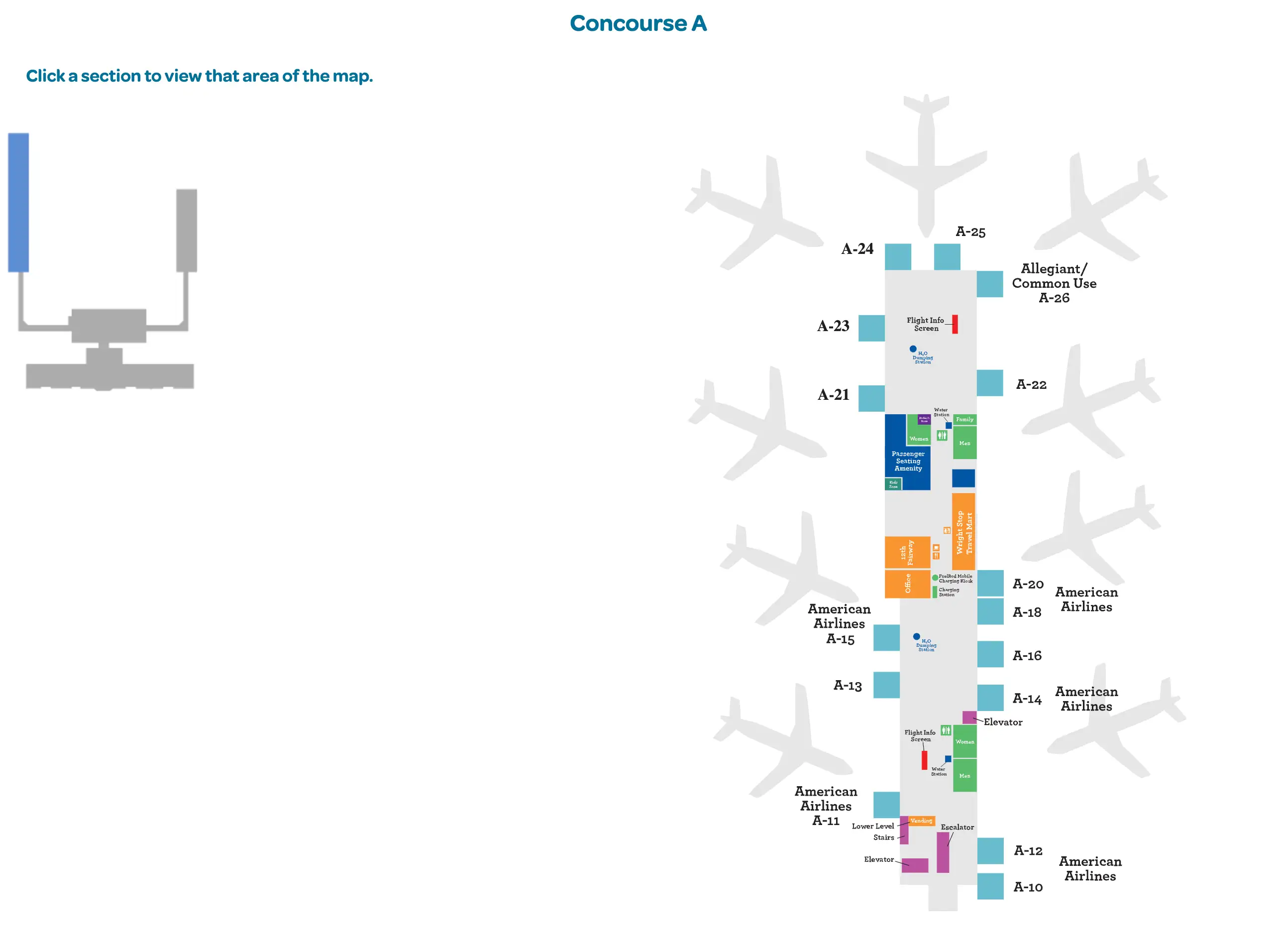
Dayton International Airport Concourse A Map 2026
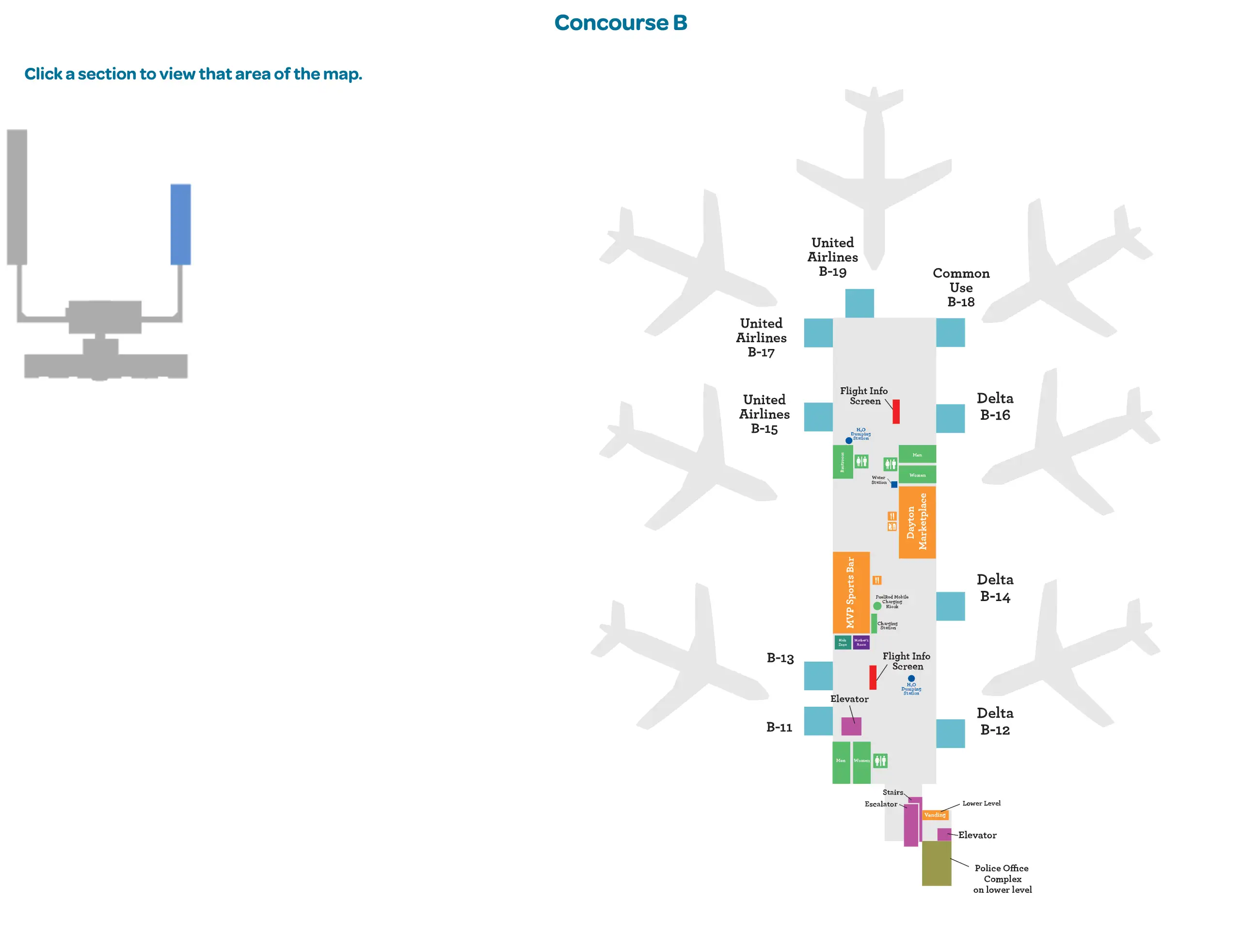
Dayton International Airport Concourse B Map 2026
2026 Dayton International Airport Map Guide
What is the exact walking distance (in feet/meters) from the far end of the Economy Lot (closest practical parking zone) to the terminal entrance doors?
The walking distance is approximately 500 feet (about 152 meters) from the far end of the Economy Lot to the main terminal entrance doors.
That “closest practical” Economy zone is reached by driving past the crowded entrance area off Boeing Drive and continuing to the absolute far end of the lot, where the terminal stays in clear line of sight. From there, the straightest route is a direct pedestrian line toward the front entrance doors on the terminal façade, typically faster than waiting for the shuttle if you’re traveling light.
Where are the Economy Lot shuttle waiting shelters located (by row/aisle markers), and what is the shortest mapped walking route from a typical parked car to the nearest shelter?
Row/aisle-specific shelter markers aren’t identified in the provided audit, but the Economy Lot does have seven shuttle waiting shelters aligned to overhead LED light-pole row signage and clustered with the ADA spaces.
- Seven shuttle shelters distributed across the Economy Lot grid
- Overhead LED light-pole row markers used to locate the nearest shelter and to relocate your car later
- ADA spaces grouped immediately beside each shelter, creating the shortest practical car-to-shelter walk when those spaces are available
- DAYrider shuttle loop frequency 4–6 minutes, with about a 2-minute ride to the terminal doors
For 6:00am departures, where does the pre-opening TSA line physically start (landmark-to-landmark), and how far is that queue start from the checkpoint entrance?
The pre-opening TSA line starts at the stanchions directly in front of the closed central security checkpoint entrance.
From the checkpoint stanchions, the line typically snakes back through the central recomposure area toward the ticketing side, often reaching the temporary USO-adjacent area near the ticket counters during the 4:00–5:00am staging surge. The audit doesn’t provide a measured feet/meters gap between the queue start point and the checkpoint entrance because, in practice, the “start” is anchored at the checkpoint mouth itself, with the length extending backward into the lobby.
Where is Great American Bagel located relative to Security (post- vs pre-security), and what is the exact walk distance from the checkpoint exit to its counter?
Great American Bagel is pre-security, positioned immediately inside the main front entrance doors in the public terminal lobby.
Because it sits landside before the checkpoint, there is no valid post-security walking route from the checkpoint exit to its counter without leaving the sterile area and re-clearing TSA. Use it as a pre-queue anchor during early departures (it opens around 4:30am per the audit) and buy coffee/food before you commit to the security line, since it’s not accessible from Concourse A or Concourse B once you’re through screening.
Where is the official rideshare pickup area at DAY, and what is the exact walking route + distance from baggage claim exit to that pickup point?
The official rideshare pickup area is on the 1st island across the roadway from baggage claim, reached via the first crosswalk outside the baggage claim exit doors.
| Segment | Route cue | Distance note |
|---|---|---|
| Baggage claim exit → crosswalk | Exit baggage claim to the curb directly outside | Start point at the baggage-claim doors |
| Crosswalk → 1st island | Take the first marked crosswalk across the immediate traffic lane | One crosswalk laterally across the roadway |
| 1st island → pickup position | Wait on the designated island pickup area | Geofenced pickup zone for Uber/Lyft |
The audit provides the route geometry (first crosswalk to the 1st island) but does not include a measured feet/meters distance for the walk.
Where on the parking/exit path are the Metropolis help/payment touchpoints located (QR signage, kiosks, staffed booth, or help instructions), and what is the exact path a driver must follow to reach them before exiting?
No pay-at-exit kiosks exist in the automated Metropolis exit lanes, so the primary help/payment touchpoint is the “Scan to Park” QR-code signage placed throughout the lots.
Drivers should scan a QR sign after parking (in Economy, Long Term, Short Term, or the Terminal Garage), complete plate + credit card registration on the mobile web flow, and then exit through the automated lane without stopping. If you did not register (or pulled a paper ticket), the required path is to leave the automated exit flow and drive to the designated staffed cashier lane instead, because the automated lanes have no hardware for ticket/credit-card payment. The audit does not specify the exact physical locations of the cashier lane or the QR signs along the drive aisle grid.
Where is the taxi stand located (which curb/door), and what is the exact walking distance from baggage claim to that stand?
The taxi stand is outside the dedicated “Limousine and Taxi” exit door next to Baggage Carousel #3, adjacent to the valet booth area.
Exiting through the Carousel #3 “Limousine and Taxi” door puts you directly onto the taxi/limo loading curb, effectively making the walk distance from baggage claim to the stand negligible once you’re at that carousel. The audit does not provide a measured feet/meters distance from the center of baggage claim to the taxi curb, but it does specify the landmark-to-landmark path: carousel #3 → “Limousine and Taxi” door → taxi curb by the valet booth.
Which curbside doors are closest to the airline check-in counters, and what is the shortest indoor walking route from those doors to the counters?
The curbside doors closest to the airline check-in counters are often not usable because the ticketing-end entrances have been obstructed/closed during modernization work.
The most reliable route is to use the central main terminal entrance doors or the baggage claim entrance doors, then walk laterally inside along the public lobby edge to reach the ticketing/check-in counters around the dust-wall-diverted construction zone. If you’re being dropped off, avoid the far “ticketing end” of the loop—use the central curb so your indoor path stays open and doesn’t force an exterior backtrack with luggage.