Daniel K Inouye International Airport Terminal 3 Map (Most Up-To-Date)
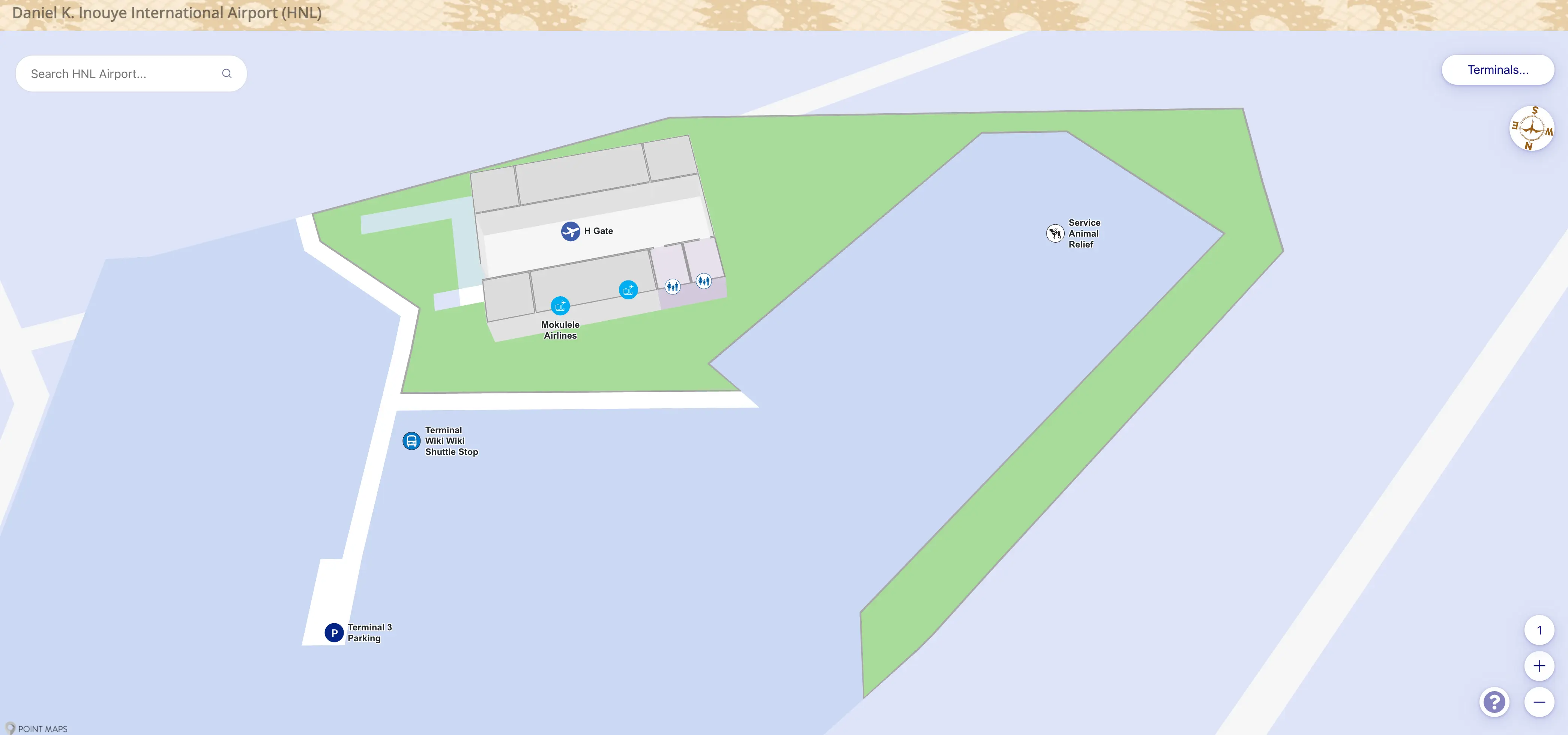
Terminal 3 at Honolulu’s primary airport complex sits as a small, single-story commuter outpost in the cargo district, not on the Terminal 1/2 horseshoe loop. Its footprint is compact and linear, fronting Aolele Street on an east–west axis, visually bracketed by Delta Cargo (west) and United Cargo (east). The curb, check-in, TSA, and boarding door all stack within a short, straight interior path—once you’re at the right building.
Map Table
| Zone | Connection | Walk Time |
|---|---|---|
| Terminal 3 front curb (Aolele St) | Wiki Wiki shuttle stop, passenger drop-off | 0–1 min |
| Terminal 3 entrance doors | Mokulele check-in counters | 1 min |
| Check-in lobby | TSA checkpoint | ~10 m |
| TSA exit / holdroom | Gate H1 apron door | 10–15 m |
Daniel K. Inouye International Airport Terminal 3 Map Strategy
- Treat Terminal 3 as an off-loop facility: no practical walk-over and no seamless airside transfer—plan a landside move and a re-clear of TSA at Terminal 3.
- Lock in the correct shuttle logic before you exit: Terminal 1 uses the center median; Terminal 2 uses the inner curb—mixing those up is how buses “ghost” you.
- Drive like you’re going to cargo, not a terminal: stay ground level, commit to Aolele Street, then scan for Delta Cargo and United Cargo as the only reliable “you’re here” landmarks.
- Assume rideshare pins can snap to Terminal 2 (often the east end near Baggage Claim 31): if the app instructions look generic, pivot immediately to the Wiki Wiki shuttle plan instead of waiting curbside at Terminal 3.
2026 Daniel K Inouye International Airport Terminal 3 Map + Printable PDF
Terminal 3 remains a physically separate Mokulele-only terminal in the Aolele Street cargo corridor, so the map is less about “finding gates” and more about avoiding the wrong road, wrong curb, or wrong shuttle island. Ground-transport patterns shaped by the Skyline-era changes still push many pickups toward Terminal 2’s dedicated zones, so printing a Terminal 3 approach + shuttle-stop map is the safest way to protect your buffer.
2026 Daniel K Inouye International Airport Terminal 3 Map Guide
What is the exact map-verified walking distance (meters) from Terminal 2 baggage claim exit to the Wiki Wiki Shuttle stop used to reach Terminal 3?
Walking distance is about 10–15 meters from a Terminal 2 baggage claim exit door to the Wiki Wiki Shuttle stop for Terminal 3 because the stop is immediate inner-curb pickup on Level 1.
The Wiki Wiki stops at Terminal 2 are positioned right outside the sliding doors along the baggage-claim frontage (commonly signed near claims like 18, 20, 25, 27/28, and 29/31). The practical wayfinding cue is the inner curb directly in front of your baggage-claim door—don’t cross to the center median, which is where rental-car shuttles and many rideshare operations cluster.
What is the exact map location (door/curb/zone label) of the Terminal 1 pickup point for the Wiki Wiki Shuttle going to Terminal 3?
The Terminal 1 pickup point is the center median island on the ground level, in the Intra-Airport Transportation / Wiki Wiki Shuttle stop zone (not the inner curb).
From Terminal 1 baggage claim, use the marked crosswalk to reach the median island that runs between the traffic lanes. The most reliable triangulation is across from the Baggage Claim 8–9 area, where multiple shuttle services stage along the same median line. If you wait at the curb directly in front of the terminal doors, the Wiki Wiki bus can pass in the outer lane without stopping because the pickup logic at Terminal 1 is median-only.
What is the exact distance (meters) from the Terminal 3 curb/drop-off point to the Mokulele check-in counter inside Terminal 3?
The Terminal 3 curb-to-check-in walk is about 15–20 meters from drop-off to the Mokulele counter.
From the Wiki Wiki / passenger drop-off curb on Aolele Street, the path is straight and flat: step onto the sidewalk at the terminal frontage, enter through the glass doors, then continue forward into the single ticket lobby where the Mokulele counters sit directly ahead. The best physical triangulation is the front curb aligned with the main entrance doors—if you’re at the correct curb, you can see the counter area within a few strides.
What is the shortest mapped vehicle route (named road sequence) to reach Terminal 3’s entrance from the airport loop, given it’s accessed via Aolele Street between Delta Cargo and United Cargo?
The shortest vehicle approach is Rodgers Boulevard (ground-level loop) → Aolele Street (eastbound) → Terminal 3 driveway, using Delta Cargo and United Cargo to confirm the correct frontage on Aolele Street.
| Route step | Named road / action | Map anchor to confirm you’re on-track |
|---|---|---|
| 1 | Airport access into Rodgers Blvd, stay ground level | Avoid the departures/upper-level ramp |
| 2 | Continue on Rodgers Blvd past Terminal 1/Terminal 2 ground-level frontage | Main terminal loop remains on your left as you proceed |
| 3 | Turn/merge onto Aolele Street, proceed eastbound | Cargo-district roadway begins; terminal cues diminish |
| 4 | Pass Delta Cargo on the left | Delta Cargo = “you’re at the right block” |
| 5 | Enter Terminal 3 driveway/curb area | Terminal 3 sits between Delta Cargo (west) and United Cargo (east) |
What is the exact mapped “rideshare pickup” point that apps commonly pin for Terminal 3, and what physical curb landmark is it tied to?
The rideshare pickup point commonly pinned for Terminal 3 is Terminal 2’s ground-level median across from Baggage Claim 31 (East End), not the Terminal 3 curb on Aolele Street.
This pin typically resolves to the Terminal 2/Terminal 3 rideshare zone that operates from the center median at the far east end of Terminal 2. The physical landmark to lock onto is Baggage Claim 31’s exit doors, then the crosswalk to the median island with rideshare staging. If your app text looks like “Terminal 2 & 3 pickup” and the map drops you near the terminal’s east end, assume it means the median opposite Claim 31 and plan your Wiki Wiki shuttle move accordingly.
What is the exact map-verified shuttle travel distance / path from the Terminal 2 Wiki Wiki stop to the Terminal 3 drop-off, including the road segment names (if shown)?
The Wiki Wiki shuttle travel distance is about 1.0 km (0.6 miles) from Terminal 2 to Terminal 3, running Rodgers Boulevard → Aolele Street to the Terminal 3 front curb.
| Segment | Road / movement | Anchor to confirm you’re on the right path |
|---|---|---|
| 1 | Depart Terminal 2 inner curb (Level 1) | Wiki Wiki stop outside baggage-claim frontage |
| 2 | Merge into airport circulation on Rodgers Boulevard | Main terminal loop falls behind as the bus exits the curb lane |
| 3 | Continue along Rodgers Blvd toward the cargo corridor | Traffic shifts from passenger curbs to service/industrial frontage |
| 4 | Turn/merge onto Aolele Street (eastbound) | Cargo facilities dominate the streetscape |
| 5 | Pull into Terminal 3 driveway and stop at the front curb | Terminal 3 sits between Delta Cargo (west) and United Cargo (east) |
Where is the Terminal 3 TSA checkpoint entrance on the Terminal 3 map, relative to check-in (e.g., “X meters past the counter”)?
The Terminal 3 TSA checkpoint entrance is about 10 meters from the Mokulele check-in counters, positioned in the same ticket lobby area and visible from the counter line.
After you finish at the Mokulele counter in the main lobby, the checkpoint is a short pivot and walk—there’s no hallway, concourse, or change of level. Use the check-in desks as the anchor: the TSA entrance sits immediately adjacent within the same room (often read as “ticket lobby checkpoint” on terminal diagrams), so if you can see the counters, you’re already within a few strides of the screening入口.
What is the exact map-verified walking distance (meters) from Terminal 3 TSA exit to the boarding door/gate-to-apron exit used for commuter flights?
Walking distance is about 10–15 meters from the Terminal 3 TSA exit to the boarding door used for commuter flights (the apron exit for Gate H1).
Past screening, you’re immediately in the small holdroom area. The key landmark is the single gate/apron door on the far wall—there isn’t a separate concourse or multiple gate corridors to navigate. Once you step out of TSA, you can typically see the boarding door within the same room, and the walk is only a few strides before you exit to the tarmac for boarding.
Where is the Terminal 3 Wiki Wiki drop-off relative to the Terminal 3 building entrance (exact side/curb/landmark on map)?
The Terminal 3 Wiki Wiki drop-off is curbside directly in front of the main entrance doors on the terminal frontage.
The shuttle pulls into the Terminal 3 driveway loop off Aolele Street and stops at the clearly signed passenger curb aligned with the glass entry. Use the building’s primary landmark—the front entrance doors—as your triangulation point: the drop-off is on that same curb line, not across the lane in the parking area. If you step off the bus and face the building, you should be facing the entrance within a few meters.
On an airport map, what is the nearest clearly labeled landmark to Terminal 3 that a driver would recognize (e.g., Delta Cargo, United Cargo) and what is the distance (meters) from that landmark to the Terminal 3 entrance?
The nearest labeled driver landmarks are Delta Cargo (~50–70 m west) and United Cargo (~80 m east) from the Terminal 3 entrance along Aolele Street.
Terminal 3’s frontage is easiest to identify by switching from “terminal” thinking to “cargo block” thinking: the building sits on Aolele Street between those two large cargo facilities. If you’re approaching and see Delta Cargo, you’re effectively at the correct block; Terminal 3’s driveway/curb appears shortly after, before the United Cargo frontage begins. These cargo names are the most map-consistent labels in the area and remain visible even when “Terminal 3” signage is easy to miss.
What is the exact mapped walking distance (meters) from Terminal 3 arrivals/apron entry to the closest restroom inside Terminal 3?
Walking distance is under 30 meters from the Terminal 3 arrivals/apron entry to the nearest public restroom because the terminal is a single-room-scale facility with restrooms on the lobby perimeter.
Arriving from the apron, you enter straight into the small Terminal 3 interior (the same compact space that handles arrivals flow and the ticket lobby area). The closest restroom is reached within a short indoor walk, with the best triangulation anchor being the main lobby perimeter walls near the central passenger flow—you don’t need to change levels, exit the building, or hunt down a corridor. If you can see the check-in lobby area, you’re already within a few steps of the nearest restroom door.
Where is the exact mapped public-bus drop-off point relative to the route you must take to reach Terminal 3’s Wiki Wiki stop (single variable: bus drop-off location vs. shuttle stop)?
The public-bus drop-off is ground level on Ala Onaona Street across from the lei stands, and it requires a ~200-meter walk to reach a Wiki Wiki shuttle stop that can take you to Terminal 3.
From the bus stop, the key constraint is that buses do not continue to Aolele Street/Terminal 3. Your route is a short walk from the Ala Onaona Street lei-stand area toward the main terminal frontage to reach the nearest Wiki Wiki pickup: either the Terminal 1 center-median stop (if you approach T1 first) or the Terminal 2 inner-curb stop (if you enter the T2 frontage). Once you’re at either terminal’s Wiki Wiki stop, you switch modes to shuttle for the Terminal 3 leg.