Daniel K Inouye International Airport Terminal 1 Map (Most Up-To-Date)
Terminal 1 at HNL is a long, linear set of “Lobby” zones feeding a central post-security core, with key functions split across levels (arrivals/baggage low, departures and most curb pickups above). The big navigation risk inside Oʻahu’s main airport hub is not finding the building—it’s losing time to one chokepoint (TSA or ag screening) and then getting hit with long walks, open-air connectors, and wrong-level pickups.
Map Table
| Zone | Connection | Walk Time |
|---|---|---|
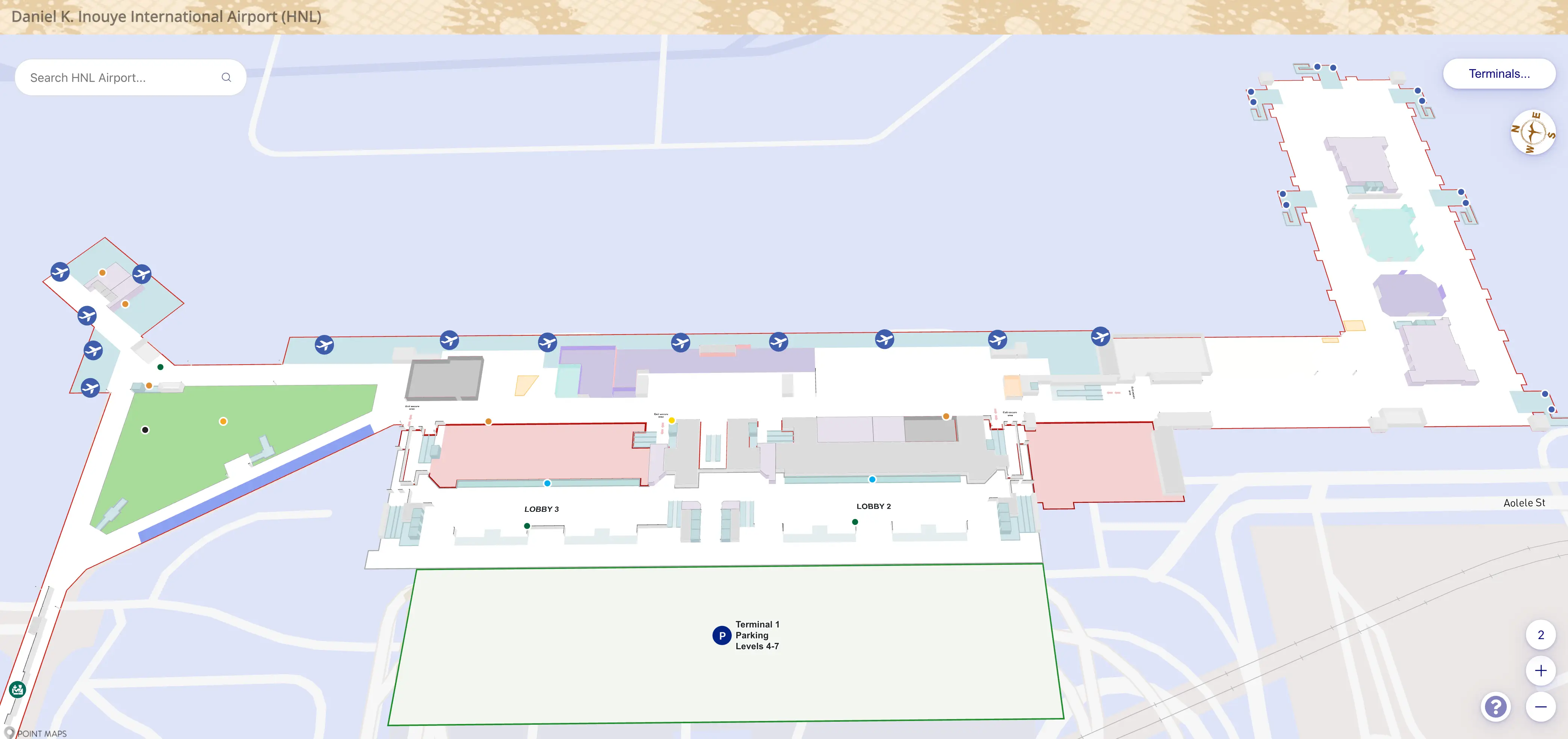
| Lobby 1 (Hawaiian check-in) | nearest TSA checkpoint | ~160 m · ~2 min |
| TSA exit (post-security) | Plumeria Lounge vertical core | ~60–80 m · ~1 min |
| Post-security makai end | Terminal 1 → Terminal 2 connector entrance | food court / retail core |
| USDA ag screening (airside) | Terminal 2 concourse entry | ~150 m · ~2 min |
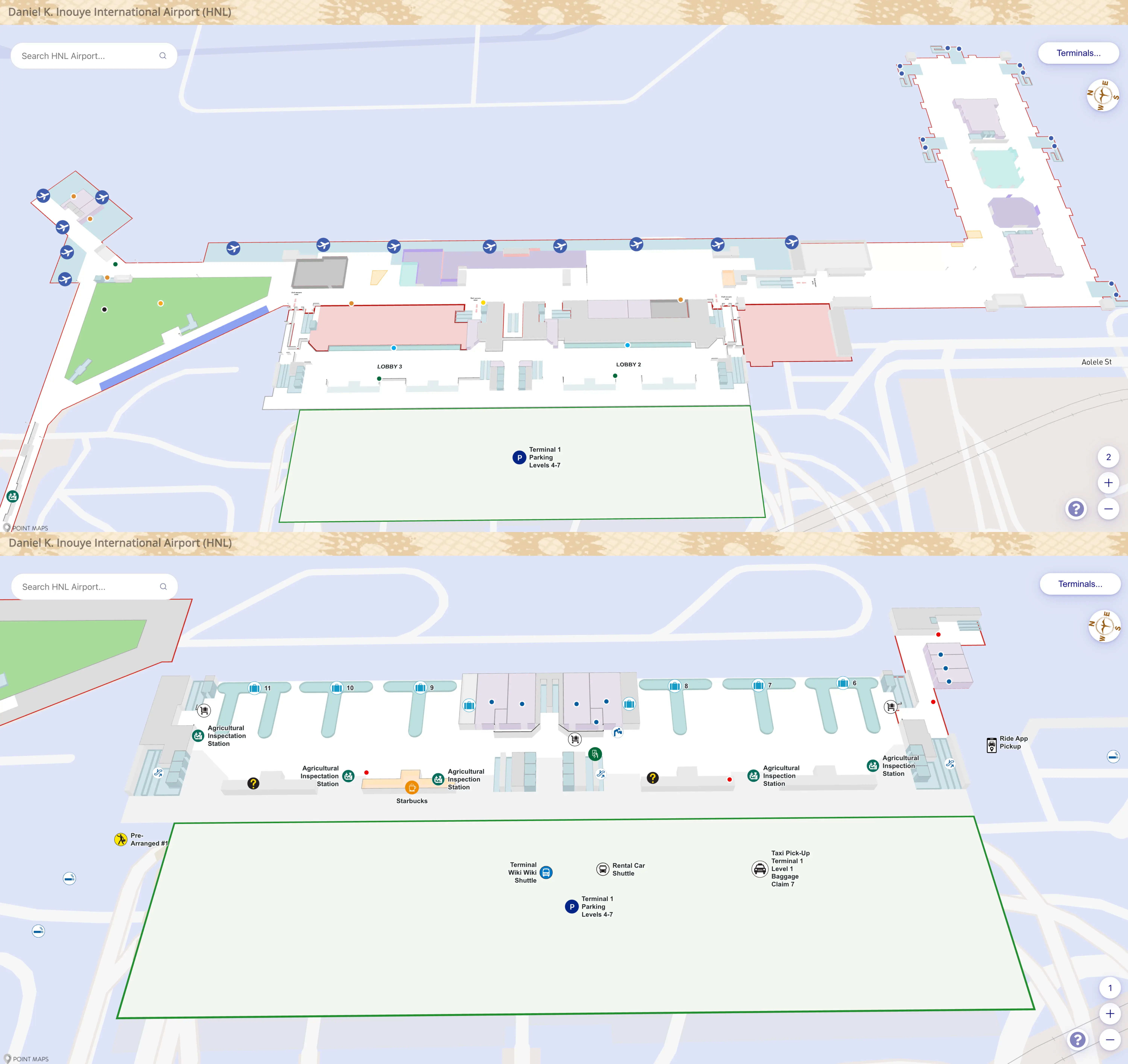
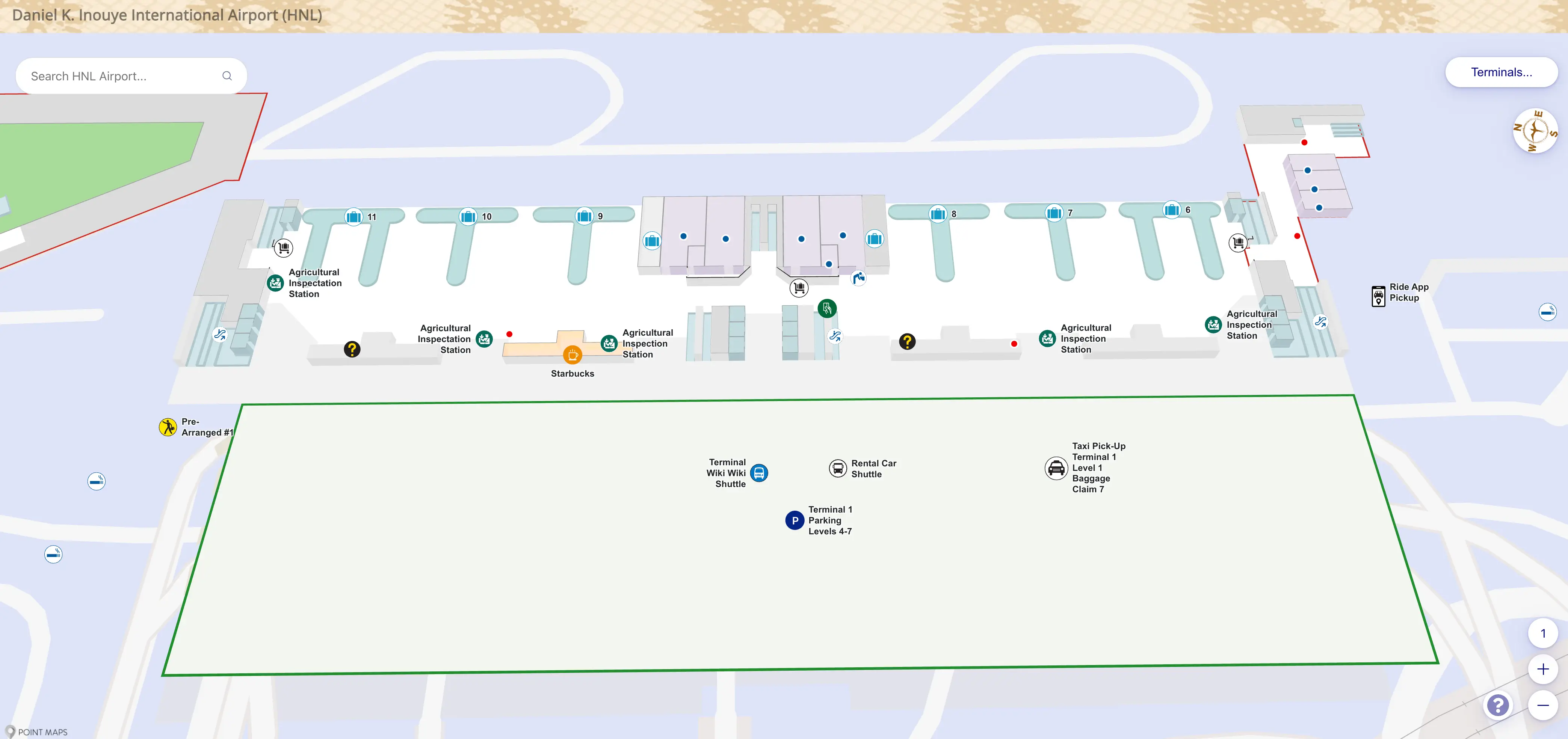
| Terminal 1 baggage claim exit (L1) | rideshare pickup median (L2, near Lobby 1) | ~100 m · level change |
| Terminal 2 E-gates arrivals corridor | Terminal 1 baggage claim | ~1,050 m · ~20–25 min |
| Skyline station egress | Terminal 1 ticketing/check-in | ~450–550 m · 3 level changes |
Daniel K. Inouye International Airport Terminal 1 Map Strategy
- Treat TSA and the USDA ag station as buffer-destroyers: the “walk” can turn into a queue spillover with zero warning, so pick your shortest correct corridor before you enter the crowd.
- Lock your level early: arrivals/baggage (Level 1) is not rideshare; rideshare is departures-level median (Level 2), so route to the nearest elevator/escalator before you exit the wrong door.
- Use the makai-end logic for Terminal 1 ↔ Terminal 2: the airside connector is a real transfer path, but the ag screening is a mandatory hard stop—plan the post-inspection walk to Terminal 2 entry as part of the transfer.
- Reduce backtracking by anchoring to one landmark at a time: Lobby 1 → checkpoint approach, checkpoint exit → vertical core for Plumeria Lounge/Level 3, baggage exit → elevator bank → Level 2 median.
2026 Daniel K Inouye International Airport Terminal 1 Map + Printable PDF
Terminal 1’s current configuration rewards “right corridor, right level” decisions: the consolidated TSA flow pulls most departures toward the same checkpoint approach, the Mauka Concourse adds real gate-walk time at the far end, and the Skyline-to-terminal approach still routes through parking/bridge infrastructure. A printable 2026 map is most useful when it shows level changes and connector chokepoints, not just gate numbers.
Daniel K Inouye International Airport Terminal 1 Level 1 Arrivals Map 2025
Daniel K Inouye International Airport Terminal 1 Level 2 Departures Map 2025
2026 Daniel K Inouye International Airport Terminal 1 Map Guide
What is the exact walking distance (meters) from Terminal 1 Hawaiian Airlines Lobby 1 check-in doors to the nearest TSA checkpoint entrance?
The walking distance is approximately 160 meters from the Terminal 1 Hawaiian Airlines Lobby 1 check-in doors to the nearest TSA checkpoint entrance.
This route runs longitudinally from Lobby 1 toward the consolidated checkpoint area (typically drawing passengers toward Lobby 2/3), using the main departures-level pedestrian spine. The distance can behave longer in practice because the checkpoint queue often spills backward into the same corridor during peak waves, turning part of that 160 meters into “standing-in-line” before you ever reach the stanchions.
What is the exact walking distance (meters) from the Terminal 1 TSA checkpoint exit to the Hawaiian Airlines Plumeria Lounge entrance (as shown on the current terminal map)?
The walking distance is approximately 60–80 meters from the Terminal 1 TSA checkpoint exit to the Hawaiian Airlines Plumeria Lounge entrance.
The shortest path starts at the checkpoint exit and heads into the immediate post-security core, then turns toward the vertical circulation node that also aligns with Wiki-Wiki shuttle wayfinding (escalators/elevators up to Level 3). The key landmark is that this vertical core is near the post-security retail/food activity zone; if you walk too far toward the gate spine (toward the A-gates), you’ll overshoot and need to backtrack to the Level 3 access point.
Where is the airside (post-security) Terminal 1 → Terminal 2 connector entrance located, relative to the Terminal 1 gates, on the current map?
The airside Terminal 1 → Terminal 2 connector entrance is at the makai (ocean-side) end of Terminal 1, beyond the main post-security retail/food core and adjacent to the gate-side circulation.
From the Terminal 1 gate spine, the connector is positioned past the central concessions zone, near the area associated with the old checkpoint circulation, where the environment transitions from enclosed Terminal 1 space into the open-air garden-style pathways leading toward Terminal 2. On the map, it reads as the “Terminal 2 / International” direction at the far makai end rather than a mid-concourse cut-through.
What is the exact walking distance (meters) from the agriculture inspection screening point on the Terminal 1 ↔ Terminal 2 airside path to the Terminal 2 concourse entry point?
The walking distance is approximately 150 meters from the agriculture inspection screening point to the Terminal 2 concourse entry point.
This segment begins immediately after clearing the USDA screening within the connector corridor and continues along the open-air connector until the path merges into Terminal 2’s main concourse flow (near the central hub that feeds the E/D-side movement). The distance matters because it is “post-choke”: even after you clear the inspection line, you still have a meaningful walk before you are actually inside Terminal 2’s concourse decision point for gates.
What is the exact walking distance (meters) from the Terminal 1 baggage claim exit to the rideshare pickup waiting area on the departures-level center median (nearest Lobby 1 pickup)?
The walking distance is approximately 100 meters from the Terminal 1 baggage claim exit to the rideshare pickup waiting area on the departures-level center median closest to Lobby 1.
That total includes three parts: the short curbside move from the baggage exit to the nearest vertical circulation, the level change up to departures (Level 2), and the final walk out to the center median pickup zone. The main failure mode is exiting at the “wrong” baggage-claim door and then having to walk a long stretch along Level 1 sidewalk before you even find the elevator/escalator that gets you up to the correct rideshare level.
Which elevator bank or escalator is the closest (by walking distance) from the Terminal 1 baggage claim exit to reach departures level (Level 2) for rideshare pickup?
The closest vertical access is the elevator bank located between Baggage Claim 8 and Baggage Claim 11.
This bank is the fastest way up from the baggage claim level (Level 1) to departures (Level 2) when your goal is the rideshare pickup on the center median near Lobby 1. The practical landmark is that it’s typically near the restrooms/structural columns rather than centered in the middle of the baggage hall, so it’s easy to miss if you exit near a different carousel cluster. If you realize you’re outside on Level 1 without seeing vertical access, you’re already in the wrong extraction lane for rideshare.
What is the exact walking distance (meters) from the Terminal 2 E-gates arrivals corridor to the Terminal 1 baggage claim carousels (fastest signed public route)?
The walking distance is approximately 1,050 meters from the Terminal 2 E-gates arrivals corridor to the Terminal 1 baggage claim carousels via the fastest signed public route.
This route runs the length of the E concourse back to Terminal 2’s central hub, continues toward the Terminal 1/Terminal 2 connector direction, traverses the inter-terminal corridor, and then continues through Terminal 1 before dropping down to baggage claim (Level 1). The critical landmark shift is the open-air connector segment: it feels like you’re “already there,” but you’re still committed to a long, exposed walk and at least one level change to reach the carousels.
Where is the nearest Wiki-Wiki shuttle stop to the Terminal 2 E-gates shown on current maps/signage paths (closest stop location, not the shuttle schedule)?
The nearest Wiki-Wiki shuttle stop is on Level 3 at Terminal 2’s central hub, right where the E concourse feeds back into the main terminal.
From the E-gates arrivals corridor, follow signs back toward Terminal 2’s main concourse hub (the junction where the long E concourse “ends” and the terminal opens up), then take the nearest escalator/elevator bank up one level to the Level 3 roadway. The key landmark is that this vertical move happens before you commit to the landside exits; if you follow the crowd out to the street-level flows, you’ve usually walked past the easiest signed path to the shuttle stop.
What is the exact walking distance (meters) from the Skyline rail station pedestrian egress to the Terminal 1 check-in/ticketing entrance, following the garage/bridge/elevator route shown on current wayfinding?
The walking distance is approximately 450–550 meters from the Skyline rail station pedestrian egress to the Terminal 1 check-in/ticketing entrance via the garage/bridge/elevator route.
The mapped path typically funnels you from the station platform area into the airport’s parking structure circulation, across a connector bridge (often with a moving walkway), then onward through the Terminal 1 parking-side access before dropping you onto the departures level for ticketing. The exact total varies by which elevator bank you catch inside the garage system—choosing a farther bank can add meaningful extra walking plus elevator wait time that isn’t visible on simple “terminal outline” maps.
How many level changes (floor transitions) are required on the fastest rail-station → Terminal 1 ticketing route (count of elevator/escalator transitions as shown on the map)?
The fastest Skyline rail-station → Terminal 1 ticketing route requires 3 level changes.
The sequence is typically a descent from the station platform interface into the garage/concourse circulation, an additional transition to align with the connecting bridge level, and then a final descent onto Terminal 1’s departures/ticketing level (Level 2). The practical navigation landmark is that the route behaves like a parking-garage transfer, not a direct terminal bridge, so elevator/escalator availability and wait time can add volatile minutes even when the horizontal distance feels manageable.
What is the exact walking distance (meters) from the Terminal 1 Parking Garage pedestrian entry to the Terminal 1 check-in lobby doors (shortest indoor/covered route)?
The walking distance is approximately 60 meters from the Terminal 1 Parking Garage pedestrian entry to the Terminal 1 check-in lobby doors via the shortest covered connection.
This is the quick bridge-to-lobby move from the garage-side pedestrian access into Terminal 1’s departures/ticketing area. The main landmark caveat is where you “land” inside Terminal 1: the garage bridge commonly feeds into the Lobby 2 side of the complex, which can still leave you with additional interior walking if your airline counter is positioned farther toward Lobby 1 or deeper along the lobby spine.
What is the exact walking distance (meters) from the Terminal 1 Parking Garage to the rideshare pickup median for Lobby 1 (shortest mapped pedestrian route)?
The walking distance is approximately 80 meters from the Terminal 1 Parking Garage to the rideshare pickup median for Lobby 1 via the shortest mapped pedestrian route.
The shortest path uses the garage’s pedestrian bridge connection that drops you onto the departures-level side, then continues directly out toward the Level 2 center median pickup area nearest Lobby 1. The key landmark advantage is that this route keeps you on the correct level (departures) from the start, avoiding the common failure mode of ending up at baggage level (Level 1) and then having to hunt for an elevator bank before you can even request pickup.


