Dane County Regional Truax Field Map (Most Up-To-Date)
Dane County Regional (Truax Field) uses a compact, linear terminal layout with a straight curb frontage (Doors 1–6) and a single post-security concourse that runs gate-to-gate without trains or shuttles. The parking ramp sits parallel to the terminal with multiple crosswalk options plus a 3rd-floor enclosed skywalk. Within Madison’s primary airport complex, the key navigation challenge isn’t size—it’s the early-morning security surge and choosing the correct checkpoint entrance.
Map Table
| Terminal | Key Airlines | Primary Function | Transfer Mode |
|---|---|---|---|
| Single terminal | Delta, United, American, Frontier, Sun Country | Domestic departures, arrivals, TSA screening | Walking, curbside drop-off, parking ramp skywalk |
Dane County Regional Truax Field Map Strategy
- Treat 4:30 AM as the true “start line” for on-time departures; arrive early enough to be in-position before the checkpoint opens and the queue compresses.
- Use the correct checkpoint on purpose: the South Checkpoint is inside Door 1 and effectively PreCheck-only, so standard screening travelers avoid the Door 1 detour.
- Build your buffer from parking reality, not airport size: lots are first-come/first-served, so plan for a forced shift from Ramp/Surface to the longer Economy walk.
- Lock in curbside exits by door number: rideshare pickup is outside Door 6 to the right, so don’t exit at the wrong door and add an outdoor end-to-end terminal walk.
2026 Dane County Regional Truax Field Map + Printable PDF
Peak operations at 2026 still hinge on the 4:30 AM TSA opening and the 5:00–6:00 AM departure bank that can flood the pre-security concourse. The terminal door set (Doors 1–6) stays the main wayfinding spine, with the South Checkpoint located inside Door 1 and functioning as PreCheck-only. Ground transport zones remain door-specific, with rideshare pickup outside Door 6 (right side).
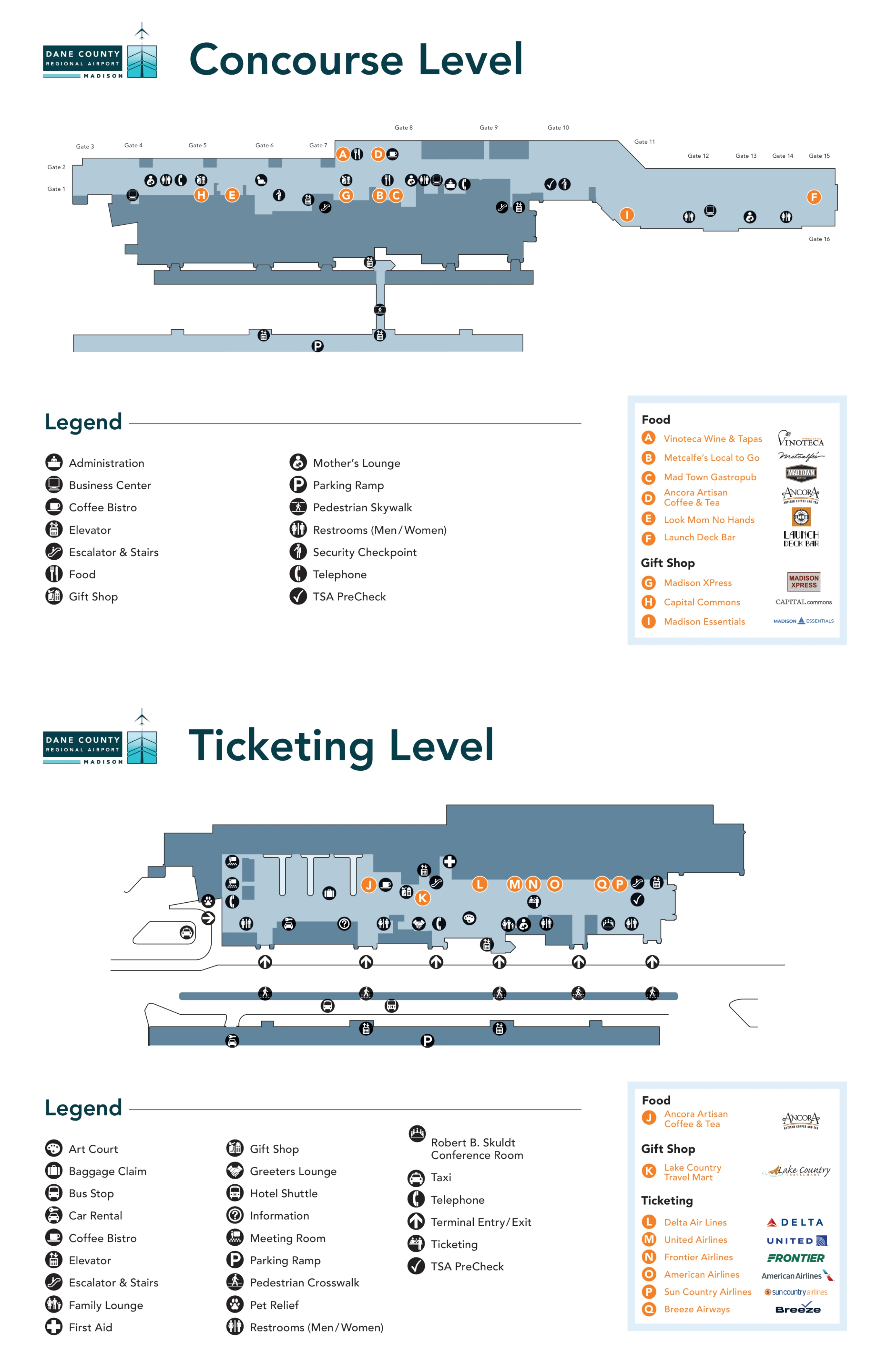
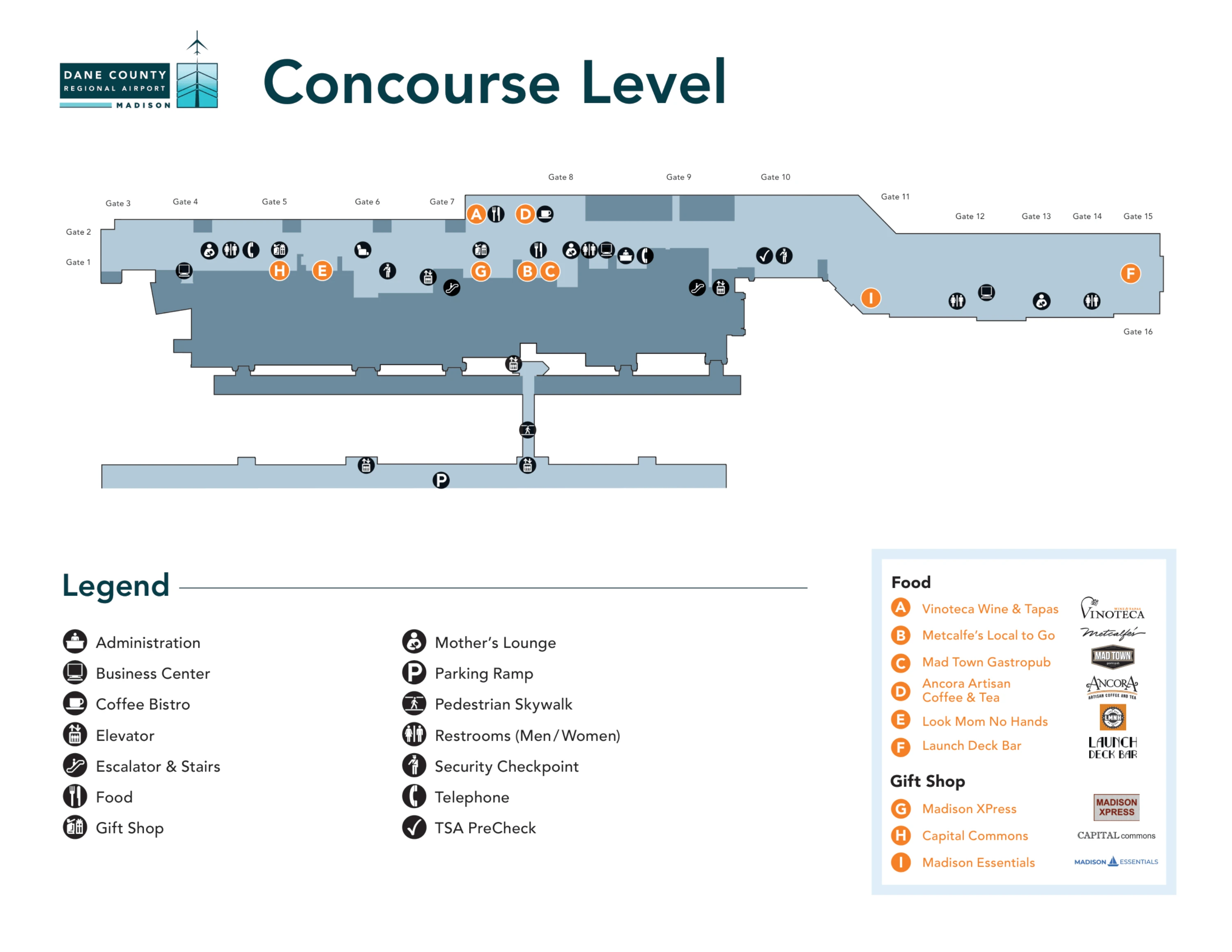
Dane County Regional Truax Field Concourse Level Map 2024-2026
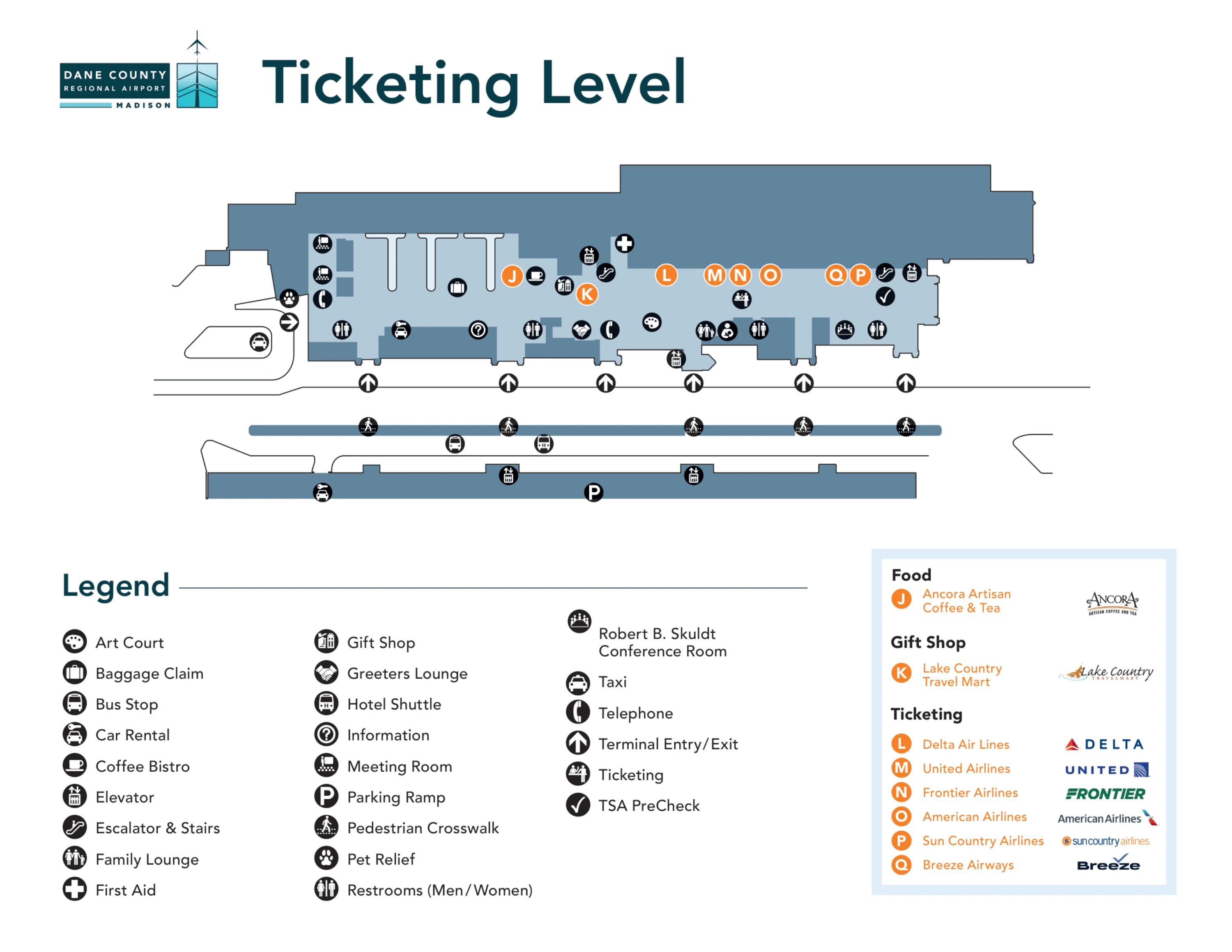
Dane County Regional Truax Field Ticketing Level Map 2024-2026
2026 Dane County Regional Truax Field Map Guide
What is the exact walking distance (in feet/meters) from the main terminal entrance to the TSA checkpoint queue start at Dane County Regional (Truax Field)?
An exact fixed walking distance isn’t published or stable because the TSA checkpoint queue start moves daily as the line expands and contracts into the pre-security concourse. During the 5:00–6:00 AM surge, the queue can extend back toward the front doors, making the “start point” variable rather than a single measurable spot.
The practical reference is the main ticketing concourse: from the terminal entry doors (Doors 1–6), you walk into the airline counter hall and then toward the security screening boundary where stanchions form the line. When TSA opens at 4:30 AM, the line often “spills” into the open public space near ticketing and seating, so the queue start may be near the checkpoint one day and near an entrance door on another.
What is the exact walking distance from the parking ramp pedestrian entry to the TSA checkpoint queue start?
An exact fixed walking distance isn’t published because both the parking ramp has multiple pedestrian entry options and the TSA checkpoint queue start shifts with crowding. The ramp-to-terminal path can begin at any of several ground-level crosswalks or the 3rd-floor enclosed skywalk, while the queue can extend far into the ticketing concourse during the 5:00–6:00 AM surge.
The usable wayfinding anchor is the terminal-side entry point you choose. The 3rd-floor skywalk drops you into the terminal interior without an exposed crosswalk, while ground-level routes feed into the Doors 1–6 frontage via marked crossings (two covered). After entering the terminal, you follow the ticketing hall toward the screening area until you hit the stanchions; on heavy mornings, the “queue start” may be well before the checkpoint itself, sometimes reaching back toward the main entrance doors.
What is the exact walking distance from the economy lot pedestrian path start to the terminal front doors?
Walking from the Economy Lot pedestrian path start to the terminal front doors is 1,500 feet (about 457 meters). That distance is the full exterior sidewalk route from the lot’s central pedestrian path origin up to the main terminal entrance along the International Lane side.
The Economy Lot path begins at the center of the lot, where the designated walking corridor feeds into the marked sidewalk heading north toward the terminal loop. The route stays outdoors and uncovered, so rolling bags, snow/ice, or strong headwinds can slow pace noticeably even though the mapped distance remains 1,500 feet. Use the terminal front doors (Doors 1–6 frontage) as the endpoint reference rather than a specific airline counter.
What is the exact walking distance from the surface lot to the terminal front doors?
Walking from the Surface Lot to the terminal front doors is 700 feet (about 213 meters). That measurement covers the standard pedestrian route from the adjacent Surface Lot across the lot-side pedestrian path to the terminal’s main entrance frontage (Doors 1–6).
The Surface Lot sits immediately beside the parking ramp and parallels the terminal face, so the walk is short but fully outdoors. Use the terminal front doors as your fixed endpoint, since airline counters are spread along the ticketing hall behind those entrances. In winter conditions, the same 700 feet can feel longer if you’re moving slower with luggage or navigating slick pavement, but the mapped distance remains 700 feet.
Where is the south checkpoint entrance located on the terminal map (door number / side of building), relative to the main entrance?
The South Checkpoint entrance is inside Door 1 at the far end of the terminal and functions as PreCheck-only, so standard screening travelers get turned around if they walk to it. Door 1 sits on the same curbside frontage as the main terminal entrances (Doors 1–6), but it’s positioned at the extreme end of that lineup rather than the central entry flow.
From the main ticketing concourse, Door 1 aligns with the end of the building where the South Checkpoint is mapped. Use the numbered exterior doors as your landmark system: if you enter through Doors 2–6 and then decide to “try the other checkpoint,” you’ll be walking all the way to Door 1, and a rejection there forces a full backtrack across the ticketing hall to rejoin the standard screening queue.
What is the exact walking distance from the TSA PreCheck (south checkpoint) entry point to the first gate area?
An exact walking distance isn’t published for this interior route, but the South Checkpoint exits directly into the low-numbered gate side of the post-security concourse, making the walk effectively immediate. The checkpoint is mapped adjacent to the first gate cluster rather than requiring a long corridor transit.
The South Checkpoint entrance is inside Door 1, and its post-screening exit lands right by the start of the sterile concourse near the earliest gate areas (the map places it next to the Gates 1/2/10 block). Use the checkpoint exit as your anchor: once you clear screening, the first visible gate seating and monitors are just beyond the exit boundary, with concessions and the rest of the concourse stretching away in a single straight line.
What is the exact walking distance from the TSA exit to Gate 6?
An exact walking distance isn’t published for the TSA exit to Gate 6 at Dane County Regional (Truax Field). Gate 6 sits in the central portion of the single post-security concourse, so the walk is short in practice, but no official feet/meters measurement is provided on public maps.
Use the main TSA exit as your start landmark: after screening, you enter the sterile concourse with gates arranged along one continuous corridor. Gate 6 is positioned around the mid-concourse area rather than at an extreme end, so you’re not doing a full “end-to-end” terminal walk. If you need a fast visual check, follow overhead gate-number signage and the central flight information displays that face the main circulation path.
What is the exact walking distance from the TSA exit to the furthest gate in the terminal?
An exact walking distance isn’t published for the TSA exit to the furthest gate at Dane County Regional (Truax Field). The furthest gate is Gate 16, and while the concourse is a single straight corridor, public maps don’t provide a measured feet/meters figure for that interior walk.
From the main TSA exit, the sterile concourse runs linearly past concessions and seating toward the highest gate numbers. Gate 16 is at the far end of that line, so it represents the longest post-security walk. Use the gate number progression as your navigation anchor: once you see double-digit gates increasing in sequence, you’re moving toward the far end; the main risk at MSN is usually not this walk, but the pre-security backlog when TSA opens at 4:30 AM.
Where is the official rideshare pickup point located on the map (curb/zone), relative to baggage claim exit doors?
The official rideshare pickup zone is outside Door 6, immediately to the right along the terminal curb. That placement matters because exiting baggage claim through the wrong door can force an outdoor walk along the full length of the curb frontage to reach the Door 6 staging area.
Use Door 6 as the fixed landmark: from the baggage claim area, follow interior wayfinding to the Door 6 exit, then step outside and turn right to reach the designated Uber/Lyft pickup location. Door-specific zones are enforced curbside, so the fastest recovery move after baggage claim is choosing the correct exit door rather than trying to meet a driver “anywhere out front.”
Where is the official cell phone lot entrance located on the airport road map relative to the terminal loop?
The official Cell Phone Lot entrance is on the inbound entrance drive along International Lane, before the terminal loop, and it’s accessed via the Employee Lot. The lot sits upstream of the curb loop so waiting vehicles stay off the departures/arrivals lanes until the passenger is actually ready at the curb.
Use International Lane inbound as your reference: as you approach the terminal area, signage directs you into the Employee Lot access to reach the no-fee “Park & Wait” Cell Phone Lot. Once your passenger confirms they’re outside (often at Door 6 for rideshare-style pickups), you exit the lot and continue forward into the terminal loop rather than circling the curb while waiting.
What is the exact curbside driving route distance (in miles/km) from the airport entrance road to the departures drop-off curb?
An exact curbside driving route distance from the International Lane airport entrance road to the departures drop-off curb isn’t published in official mapping or airport documentation. The approach must be treated as a variable-time segment driven by live curb congestion, weather, and merge behavior into the terminal loop rather than a fixed miles/km constant.
The reliable anchor is the named roadway: vehicles enter the airport complex on International Lane and follow signage into the terminal loop for departures curb access. Because the distance metric isn’t provided, the controllable strategy is reducing variance—use the correct lane early for departures, avoid unnecessary parking-lot circling if you’re dropping off, and assume slower movement during the 5:00–6:00 AM bank when multiple flights stack passengers at the curb and inside the ticketing hall.
What is the exact walking distance from baggage claim to the parking ramp pay station / exit path?
An exact walking distance from baggage claim to the parking ramp pay stations or the ramp exit path isn’t published. The ramp runs directly parallel to the terminal and is reached via the curbside exit and one of the ramp crosswalks (or by navigating to the elevators for the 3rd-floor skywalk), but official public materials don’t provide a feet/meters measurement for this interior-to-ramp route.
Use the baggage claim doors as your anchor: after collecting bags, exit the terminal to the curb and align with a marked crosswalk leading into the parking ramp structure. If you parked on an upper level and want a fully enclosed option, route toward the ramp-side elevators that connect to the 3rd-floor skywalk. The key time variable is choosing the correct exit door and crosswalk, not the total distance.
Where is the economy lot pedestrian route (sidewalk/crossing points) shown on the map, and what is its measured length?
The Economy Lot pedestrian route begins at the center of the Economy Lot and follows the designated sidewalk corridor north toward the terminal frontage, ending at the terminal front doors. The measured length of that mapped pedestrian route is 1,500 feet (about 457 meters).
The map depicts the route as a defined exterior walking path rather than an indoor connector: you leave the lot via the central pedestrian path start, stay on the marked sidewalk alignment along the airport side of International Lane/terminal approach area, and continue straight into the Doors 1–6 entrance frontage. Because the route is uncovered, the crossing and sidewalk segments are most sensitive to winter conditions, but the mapped distance remains 1,500 feet.
Where is the overflow/alternate parking area (if any) shown on the airport map, relative to the main lots and terminal?
No designated overflow or alternate public parking area is shown on the official airport parking map. The only nearby extra lots marked beyond the Ramp, Surface, and Economy facilities are restricted-use areas, not commercial overflow.
On the road map, the main public parking inventory clusters around the terminal: the Parking Ramp and Surface Lot sit closest and parallel to the building, while the Economy Lot is farther south along International Lane with the 1,500-foot walk. A Permit Only Lot and an Employee Lot appear near the entrance-drive area by the Cell Phone Lot access, but they are not overflow options for travelers—so if the Ramp, Surface, and Economy are full, there is no mapped on-site fallback.
Archive Dane County Regional Truax Field Map
Below are all historical map versions for Dane County Regional Truax Field. Each year includes the official map available for that period, presented as both WebP and PDF.
2024-2026 Dane County Regional Truax Field Map (Official 2024 Edition)


