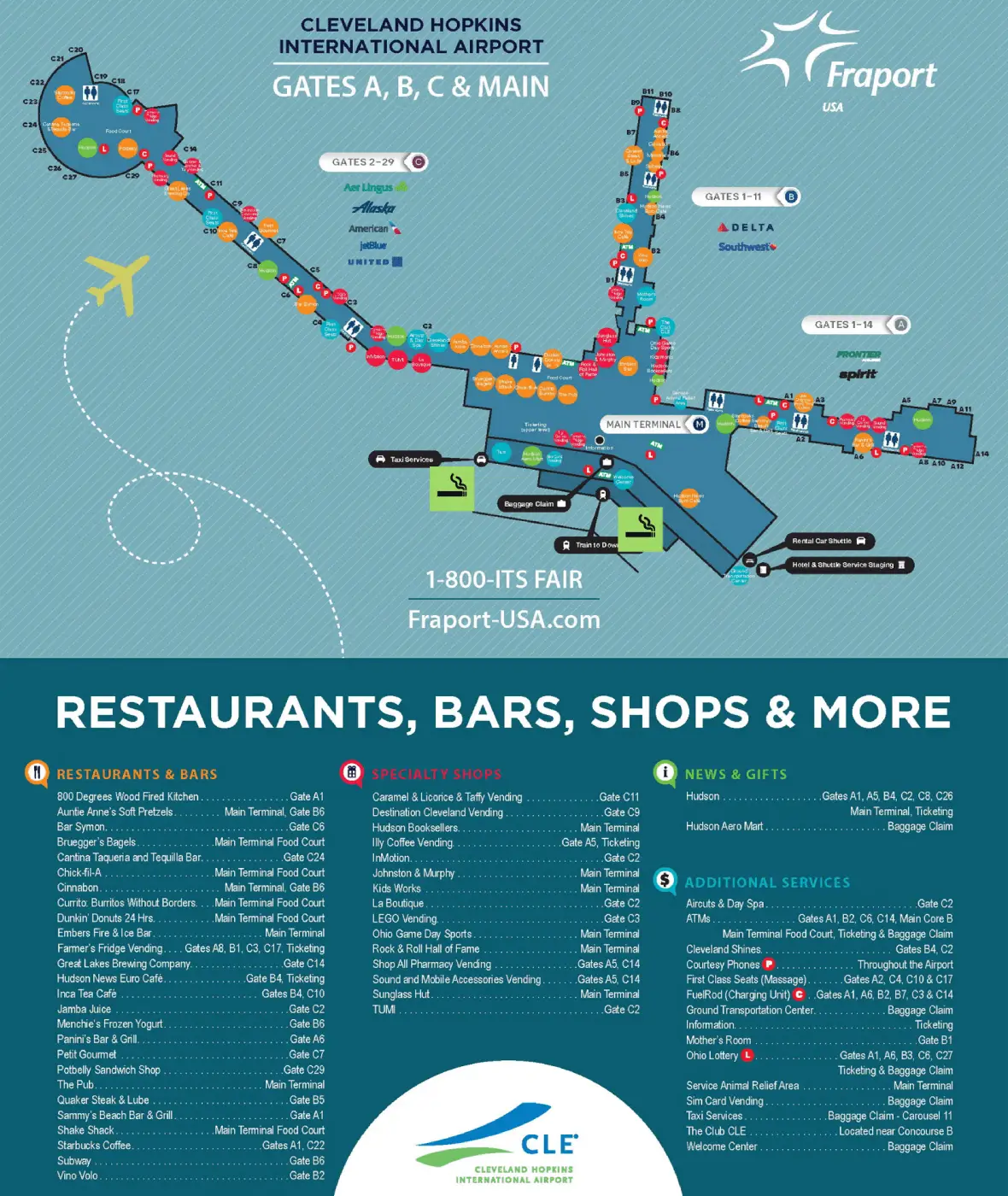
Cleveland Hopkins International Airport Map (Most Up-To-Date)
Cleveland Hopkins International Airport is a long, linear headhouse “bar” running north–south, with Concourses A (north), B (center), and C (south) branching from the same central processing spine. The building reads as one continuous corridor (roughly 1,200–1,500 ft end-to-end), but flows aren’t intuitive because security, baggage, rail access, and shuttles pull you in opposite directions. Within Cleveland’s main airport grounds, the biggest time-saver is committing early to the correct end (North vs South) before you start walking or looping curbside.
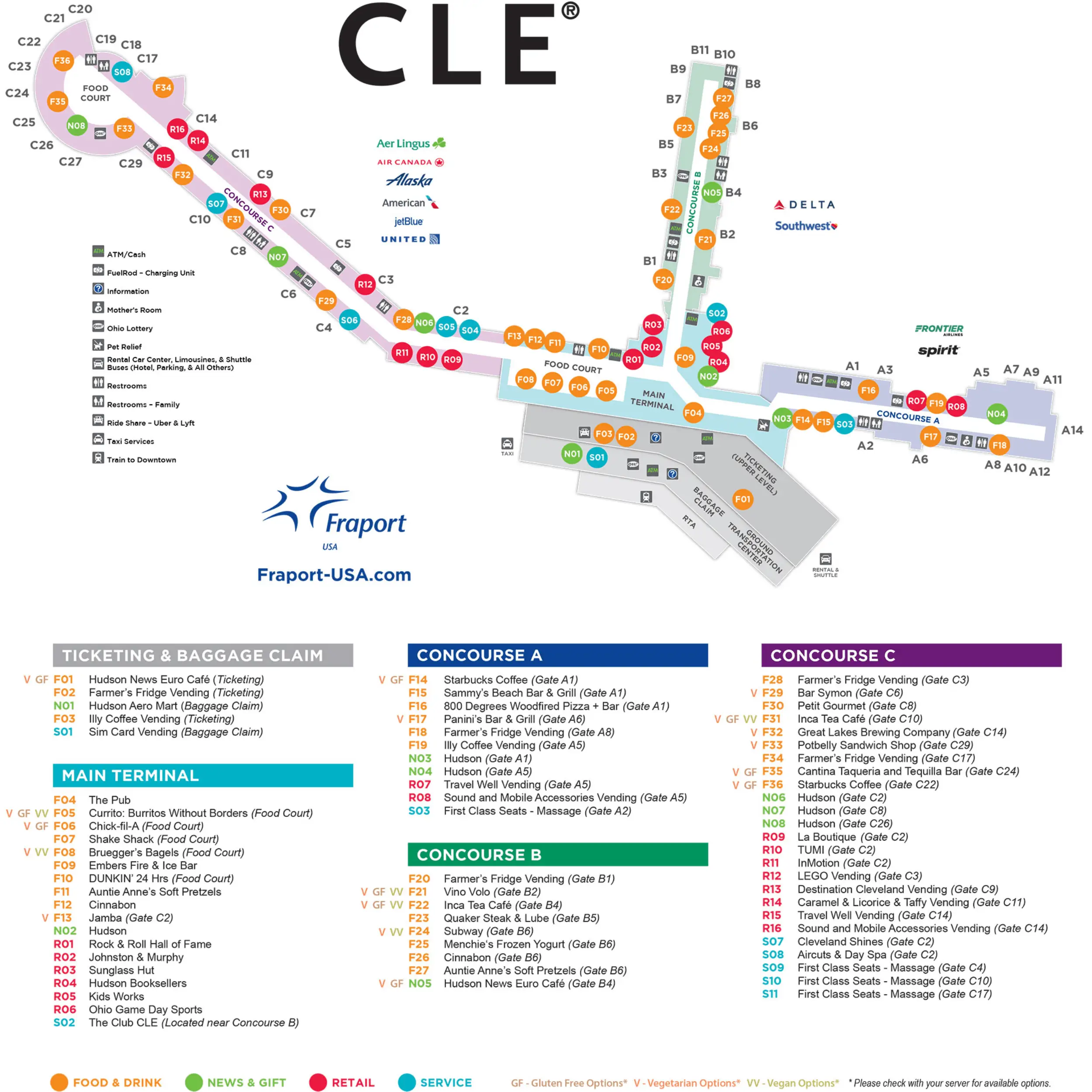
Map Table
| Terminal | Key Airlines | Primary Function | Transfer Mode |
|---|---|---|---|
| Concourse A (North) | Frontier, Spirit | Low-cost, some international | Walk (airside), Ground Transportation Center shuttles |
| Concourse B (Central) | Delta, Southwest | Central gates, main vertical core | Walk (airside), rail-to-terminal core |
| Concourse C (South) | United, American | Long concourse, highest volume | Walk (airside), South checkpoint |
| Ground Transportation Center (North, Level 1) | Rental cars, hotels, offsite lots | Shuttle hub, curbside bus concentration | Covered walk, shuttle |
Cleveland Hopkins International Airport Map Strategy
- Use the checkpoint that minimizes total failure risk, not the one that “looks closest”: the Central checkpoint can beat the South checkpoint during volatility, but only if your airside walk is still shorter than a blown queue.
- Treat Arrivals Door 1–3 (north) as shuttle territory and Arrivals Door 8–10 (south) as private-pickup territory; if you guess wrong at curbside, commit to a re-loop plan instead of stopping.
- For rental cars, stay indoors on the baggage-claim level until Door 1, then take the covered walk to the Ground Transportation Center pickup island—exiting mid-terminal forces slower curb walking.
- Identify the correct vertical core before moving: the wrong elevator or escalator bank can strand you at the wrong end and convert a 150-foot move into an 800–1,000-foot haul.
2026 Cleveland Hopkins International Airport Map + Printable PDF
Current operations at Cleveland Hopkins International Airport still behave like a layered, retrofit terminal: checkpoint availability and security throughput swing fast, and ground-side routing punishes wrong-lane or wrong-door choices with forced re-loops. The 2026 map view that matters is the “decision-point map”—how to go cleanly between security, gates, baggage claim, rail access, Arrivals/Departures curbs, and the Ground Transportation Center without getting trapped in the wrong end or wrong lane.
2026 Cleveland Hopkins International Airport Map Guide
What is the exact walking distance (in feet/meters) from the South TSA checkpoint entrance to the closest Concourse C gate cluster (first set of gates after security)?
Walking is approximately 200 feet (60 meters) from the South security checkpoint exit/recomposition area to the first Concourse C gates (starting at Gate C2). The South checkpoint is effectively built into Concourse C’s entrance, so the “first gates after security” appear almost immediately once you clear screening and recomposure.
| Segment | Distance |
|---|---|
| South checkpoint recomposure → first Concourse C gate area (Gate C2) | ~200 ft / ~60 m |
| Context anchor | Concourse C entrance throat (immediately past South checkpoint) |
What is the exact driving path (turn-by-turn road sequence) from the CLE cell phone lot exit to the Arrivals pickup curb without entering any restricted/commercial-only segments?
The safe public-vehicle route is the Jackson Road exit sequence that feeds Terminal/Arrivals, then stays in the public lanes to the Lower Level roadway. The dealbreaker is drifting into marked commercial/inner-drive segments near the Jackson Road intersection, which can trap you in bus-only flow or force an exit-and-reapproach.
Follow this sequence: exit the Cell Phone Lot and turn right onto Jackson Road, continue about 0.1 miles, turn right onto the signed airport access road for Terminal/Arrivals, follow overhead signs for Arrivals/Baggage Claim, keep left at the split to take the ramp down to the Lower Level roadway, then merge into general-purpose lanes and approach the Arrivals curb by door/pillar number.
Where exactly is the Ground Transportation Center (GTC) on the terminal map (north end, baggage level), and what is the shortest indoor walking route from Baggage Claim “Welcome Center” to the rental-car shuttle terminal?
The Ground Transportation Center is at the extreme north end of Cleveland Hopkins International Airport on the baggage-claim level (Level 1), aligned with Door 1 and the shuttle pickup islands outside. The dealbreaker is exiting mid-terminal (or at the south doors) expecting a shuttle stop—there isn’t one, and the curb walk is slower and messier.
Start at the Welcome Center (between Carousels 5 and 6), face north (away from the United/American end), and walk straight down the baggage hall about 450–500 feet (137–152 meters), passing Carousels 4, 3, 2, and 1. Stay indoors until Door 1, exit at Door 1, then follow the covered “Rental Car Shuttle” walk to the pickup island (commonly signed for Spot 3).
What is the exact walking distance from Baggage Claim (Door/Pillar area) to the Upper/Departures curb using the nearest vertical connection (elevator/escalator)?
Walking is approximately 100–120 feet (30–36 meters) from a central baggage-claim door/pillar area to the Upper/Departures curb using the nearest vertical core. The fastest switch happens at the central vertical circulation bank beside the Welcome Center; choosing a farther elevator/escalator bank can turn this into a much longer indoor haul before you ever go up.
From a central Arrivals pillar (around Door 5), walk about 50 feet inward to the escalator/elevator bank next to the Welcome Center, go up one level to ticketing, then walk about 50 feet outward to the Departures curb vestibule. This distance excludes the vertical ride time, which is typically a short escalator run or a brief elevator trip.
Which specific elevator bank (location on the baggage-level map) is closest to Claim 3, and what is the shortest path from that elevator bank to the GTC rental-car shuttle terminal?
The elevator bank closest to Claim 3 is the north-central elevator bank positioned directly across from Claims 3 and 4 on the baggage-claim level. The dealbreaker is using the central Welcome Center vertical core by habit, which adds extra backtracking when you’re trying to reach the Ground Transportation Center quickly.
From the Claim 3/4 elevator bank, walk north about 100 feet to Door 1, exit at Door 1, and the Ground Transportation Center rental-car shuttle pickup is immediately outside via the covered walkway (signed for the shuttle island/Spot 3). Total walking distance from the elevator bank to the shuttle pickup is under 150 feet (45 meters), anchored by Door 1 at the north end.
If TSA queues extend “checkpoint-to-checkpoint,” what is the mapped corridor distance between the North checkpoint entrance and the South checkpoint entrance (straight-line vs walkable path)?
Walking is approximately 900–1,000 feet (275–305 meters) between the North checkpoint entrance and the South checkpoint entrance along the ticketing-level corridor. The dealbreaker is assuming a “quick swap” between checkpoints—this cross-terminal walk, plus reorienting with bags, can cost several minutes even before you rejoin a new queue.
| Measurement | Distance | Anchor |
|---|---|---|
| Straight-line (estimated) | ~750–850 ft / ~230–260 m | end-to-end across the headhouse span |
| Walkable corridor path | ~900–1,000 ft / ~275–305 m | along the ticketing lobby spine (North counters → South counters) |
What is the exact walking distance from the rental-car shuttle drop-off (terminal side) to the nearest airline check-in counters (ticketing level)?
Walking is approximately 200–250 feet (60–75 meters) from the rental-car shuttle drop-off at the Ground Transportation Center to the nearest airline check-in counters on the ticketing level. The nearest counters are the north-end airlines (Frontier/Spirit), so this is a short “up one level and straight ahead” move.
From the shuttle drop-off at the Ground Transportation Center (north end, baggage level), enter Door 1, take the north elevator/escalator bank up to ticketing, then walk forward to the first check-in positions at the north end. The same drop-off becomes a very different problem for south-end airlines: reaching United’s ticketing zone requires traversing essentially the full length of the ticketing hall (well over 1,000 feet), anchored by the north-to-south corridor.
What is the shortest indoor route from the RTA Red Line station entrance to the primary TSA checkpoint, measured as walking distance and number of decision points (turns/intersections)?
A roughly 400-foot (120-meter) indoor path with 5 decision points is the shortest route from the RTA Red Line station entrance to the primary security checkpoint area. The dealbreaker is the forced “double-ascent”: there is no single express vertical ride from the rail level to the checkpoint level, so you must transition through baggage claim and re-orient in the Welcome Center.
| Step | Landmark anchor | Distance / Action |
|---|---|---|
| 1 | RTA fare gates (Level 0) | walk ~200 ft straight toward the central core |
| 2 | Central vertical core | go up to Level 1 (baggage claim) |
| 3 | Welcome Center atrium | cross ~50 ft to the next vertical bank |
| 4 | Second escalator/elevator bank | go up to Level 2 (ticketing/security level) |
| 5 | Ticketing corridor at checkpoints | walk ~100 ft, then turn toward your checkpoint |
Total horizontal walking is ~400 ft / ~120 m, with 5 decision points anchored by the central vertical core and the Welcome Center.
On the curbside map, what is the distance from Arrivals Door/Pillar 1 to Door/Pillar 8 along the pickup loop (the “go to the far end to avoid traffic” tactic)?
Walking is approximately 560–600 feet (170–180 meters) from Arrivals Door/Pillar 1 to Arrivals Door/Pillar 8 along the curbside frontage. The dealbreaker is trying to get picked up in the Door 1–3 zone where shuttle buses dominate; the faster recovery is walking inside to the south doors, then stepping out at Door 8–10.
The curb doors are spaced in repeating bays; Door 1 to Door 8 is seven door intervals along the same façade. In practical terms, this is a 2–3 minute walk for a passenger, anchored by the Arrivals pillar numbers—often far quicker than a driver sitting in north-end curb congestion for 10+ minutes.
Where is the baggage-claim escalator referenced as “between carousels 2 & 3” located on the map, and what is the shortest path from that escalator to check-in?
The escalator “between Carousels 2 and 3” is in the north zone of the baggage-claim level, feeding up to the north-central ticketing corridor. The dealbreaker is using this escalator if you need south-end check-in (especially United), because it deposits you at the wrong end and forces a long cross-terminal walk.
From that escalator, ride up to ticketing and then use the corridor immediately outside the escalator landing. Turn right for the nearest north-end check-in counters (about 100 feet). Turn left for central counters (about 150 feet). Continuing left (southbound) to the south-end counters becomes a much longer walk (about 700 feet), anchored by the north-central escalator landing as your starting point.
What is the exact walking distance from the rental-car shuttle boarding point to Claim 9, using the escalator bank nearest Claim 9?
Walking is approximately 800 feet (240 meters) from the rental-car shuttle boarding point at the Ground Transportation Center to Claim 9 using the baggage-level path. The dealbreaker is expecting a shortcut—this is the “long south walk” along the baggage hall, and it is slow with heavy bags or peak-time cross-traffic.
Enter the terminal at Door 1 by the Ground Transportation Center, then walk south inside the baggage-claim hall past the carousel sequence toward the south-side claims until you reach Claim 9. The route is essentially linear with no true indoor bypass; your anchors are Door 1 at the north end and the Claim 9 carousel zone at the south end.
What is the shortest drivable loop length (in miles/km) to “circle back” from Arrivals pickup to Arrivals pickup again (one full loop) for drivers forced to re-loop due to curb congestion?
A one-full re-loop is approximately 0.9–1.0 miles (1.4–1.6 km) from Arrivals pickup back to Arrivals pickup. The dealbreaker is waiting at the curb: “active loading only” enforcement forces you into this loop, and one miss usually costs several minutes.
After leaving the Arrivals curb, take the Park Road divert (left) before you commit to the highway merge, circle the parking complex by the Smart Parking Garage/Orange Lot area, then feed back onto the terminal approach to re-enter the Arrivals curb. At typical congested speeds plus merges, this loop commonly consumes about 5–7 minutes per cycle.
Archive Cleveland Hopkins International Airport Map
Below are all historical map versions for Cleveland Hopkins International Airport. Each year includes the official map available for that period, presented as both WebP and PDF.
2023 Cleveland Hopkins International Airport Map