Boston Logan International Airport Map (Most Up-To-Date)
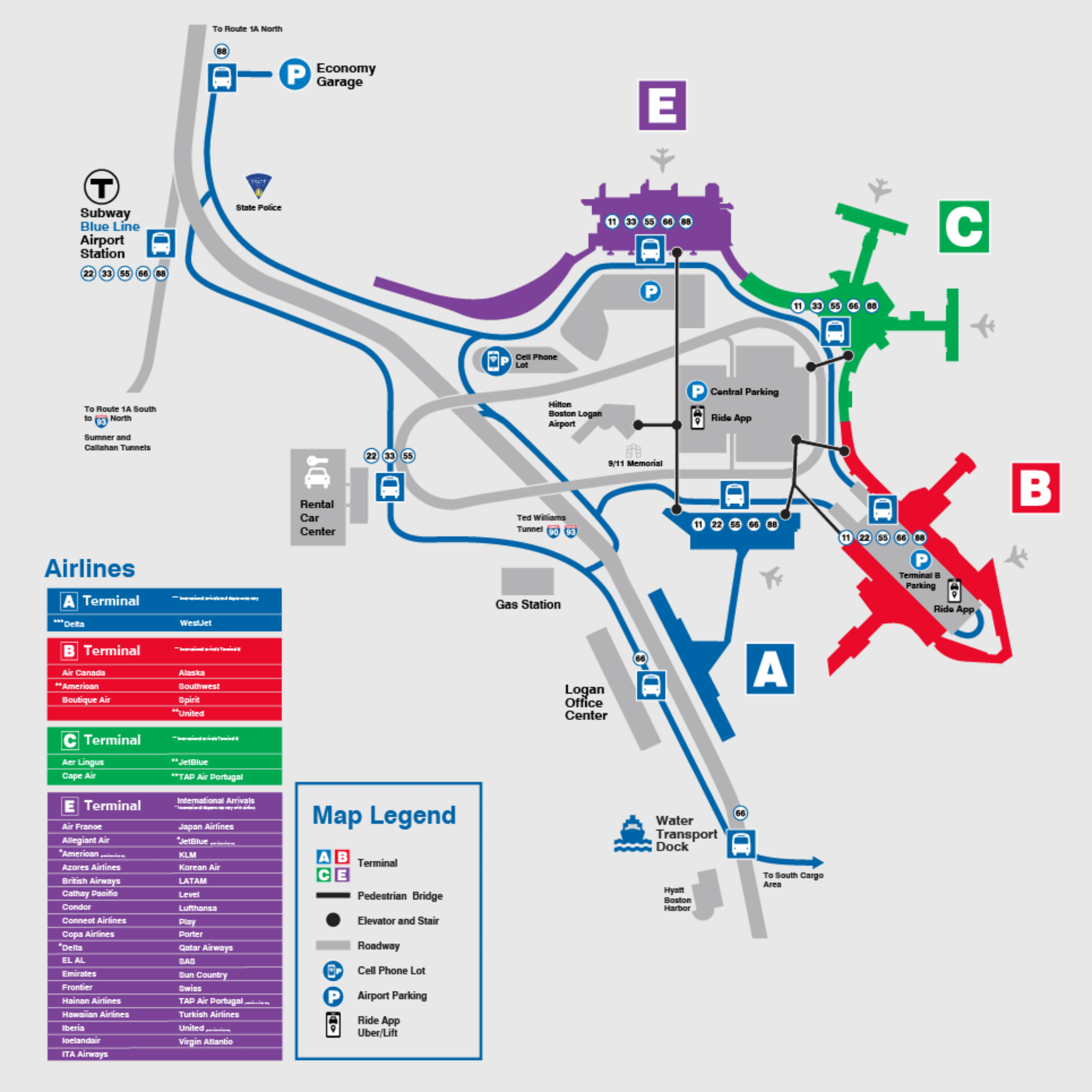
Boston Logan (BOS) is a hub-and-spoke terminal layout wrapped around one dominant landmark: the Central Parking Garage. Terminal islands (A, B, C, E) sit on the perimeter, while the most reliable pedestrian “spine” runs above the road loop on garage Level 4 via enclosed skybridges and moving walkways. Most ground access and transfers hinge on choosing the right elevation (curb Level 1 vs bridges Level 4) within Boston’s main airport complex.
Map Table
| Terminal | Key Airlines | Primary Function | Transfer Mode |
|---|---|---|---|
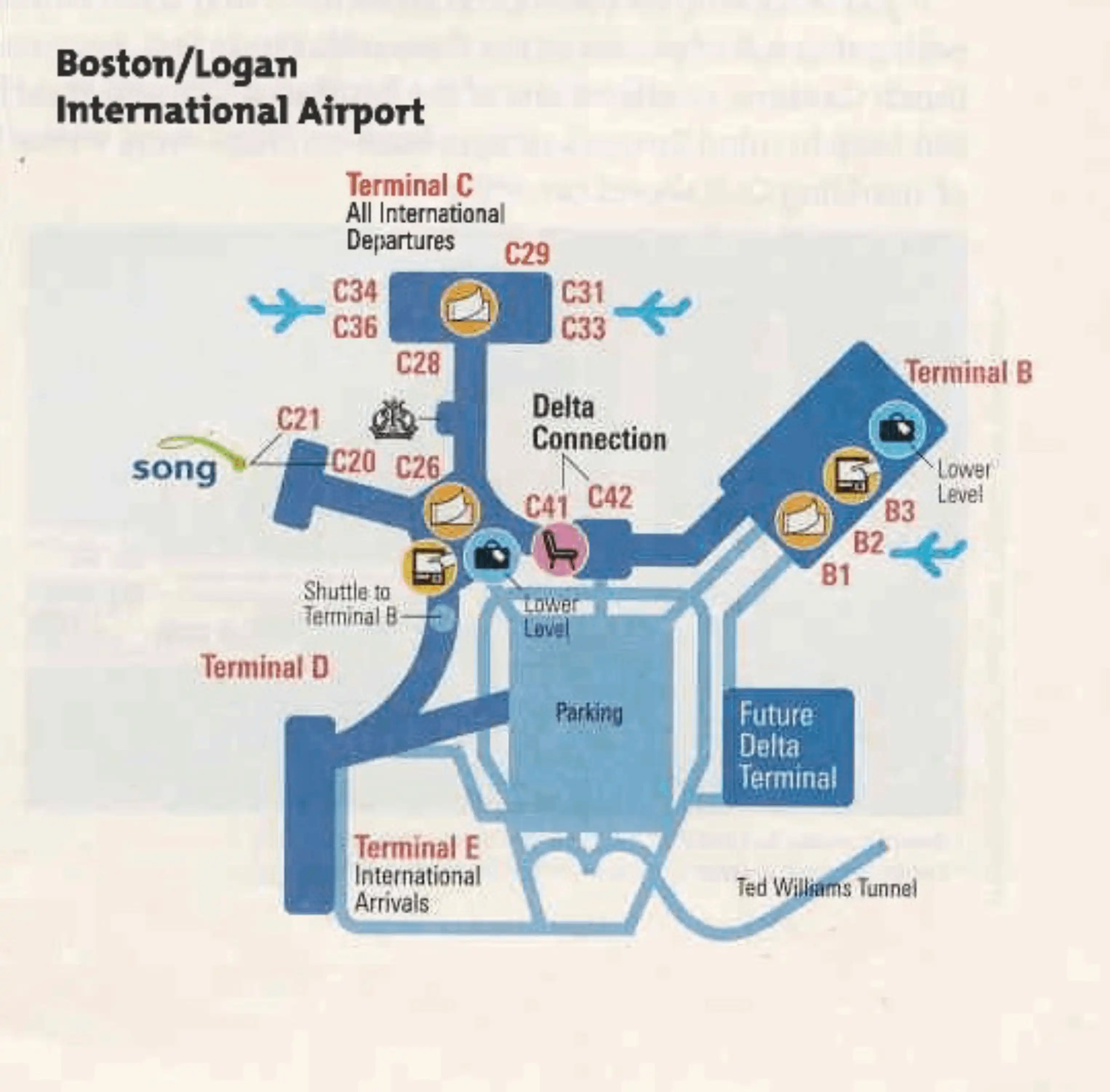
| Terminal A | Delta | domestic hub, some international | Central Parking Level 4 bridges; Massport shuttles; Terminal A tunnel (Main↔Satellite) |
| Terminal B | American, United, Alaska, Southwest, Spirit | domestic, regional | Terminal B garage connectors; Massport shuttles; limited Central Parking reliance |
| Terminal C | JetBlue | domestic hub | Central Parking Level 4 bridges; Massport shuttles |
| Terminal E | international carriers | CBP arrivals, long-haul | Central Parking Level 4 bridges; Massport shuttles; Door E107 ground transport zone |
Boston Logan International Airport Map Strategy
- Treat “Level 4 or Level 1” as the core decision: Level 4 skybridges for predictable, indoor-heavy transfers; Level 1 curb only when a bus is unavoidable.
- For international → domestic connections, plan for exit + terminal change + TSA re-screening; use the Central Parking cut-through to remove bus-queue uncertainty when heading E→B or B→C.
- Anchor all bus moves to door numbers, not terminal names: Terminal E shuttles at Door E107; avoid drifting to nearby limo/scheduled-bus zones by mistake.
- Reduce stop-order anxiety by choosing deterministic paths first (garage bridges), and using shuttles only when distance or exposure makes walking the higher-risk option (MBTA Airport Station → terminals, Rental Car Center).
2026 Logan International Airport Map + Printable PDF
In 2026, BOS navigation still revolves around the Central Parking Garage as the default connector when airside links don’t apply (especially after Terminal E customs). Terminal B remains the exception case for rideshare, while Terminal E ground transport depends on door-accurate wayfinding. Expect the fastest outcomes when you route upward to Level 4 for walking, and downward to Level 1 only for shuttles, rentals, and curb pickups.
2026 Boston Logan International Airport Map Guide
What is the shortest walk route distance from Terminal E Arrivals exit to Terminal B TSA checkpoint (via Central Parking/garage cut-through)?
Walking is approximately 0.5 to 0.6 miles (15–20 minutes) when you use the Central Parking Garage Level 4 skybridge cut-through instead of waiting for a shuttle. Start from Terminal E Arrivals (Level 1), go straight to the elevator bank inside Terminal E, ride up to Level 4, and take the enclosed Terminal E skybridge into Central Parking. Cross the garage spine toward the Terminal B connector bridge (follow overhead “Terminal B” wayfinding), then enter Terminal B’s garage/bridge level and descend to Departures for the TSA checkpoints (B1 vs B2 depends on airline).
Where is the exact curbside location (door/zone) of the inter-terminal shuttle pickup at Terminal E?
The inter-terminal shuttle pickup is outside Door E107 on the Ground Transportation curb, using the bus island across the crosswalk from the terminal doors. From the Terminal E customs/public arrivals exit area (typically near the middle doors around E104–E105), turn left and walk toward the higher-numbered doors until you reach E107. Exit at Door E107, then cross the marked crosswalk to the outer curb island where the blue-and-white Massport shuttles load. Use the stop signs labeled for on-airport shuttles/scheduled bus zones as your confirmation; if you’re standing by limo/private-van signage near E104, you’re in the wrong pickup area.
What is the exact walking path + distance from MBTA Airport Station shuttle drop to the closest Terminal E entrance?
Walking is approximately 0.5 to 0.7 miles (15–20 minutes) from MBTA Airport Station to Terminal E’s closest ground-level entrance if you skip the shuttle. Exit the stationhouse, turn left immediately (away from the bus bays), and walk to the Logan Airport Service Road crossing—the critical delay point because signal timing and traffic priority can be unpredictable. After crossing, turn right and follow the sidewalk parallel to the service road, passing the State Police/industrial buildings (UPS area) with Terminal E’s distinctive structure visible ahead. The sidewalk feeds into Terminal E Arrivals level curb/entrances, but the route is exposed and feels hostile due to fast service vehicles.
Where is the exact Terminal B drop-off point for the Blue Line/terminal shuttle, and how far is it to the main check-in hall?
The Blue Line/terminal shuttle drops at two Terminal B arrivals-curb stops: B1 near Doors B103–B105 and B2 near Doors B110–B115, depending on your airline. After you step off on Level 1 (Arrivals), enter through the nearest door and go straight to the escalators/elevators typically within 50–100 feet of the entry. The walk from shuttle curb to the main ticketing/check-in level is generally under 300 feet total once you include the short indoor approach plus the vertical ride up to Departures. Missing your correct stop can add a long lateral walk inside the U-shaped terminal, so match the stop to your carrier before exiting the bus.
Where is the Rental Car Center shuttle pickup at Terminal A (level + door/curb zone)?
The Rental Car Center shuttle pickup is on Terminal A Arrivals (Level 1) at the Ground Transportation curb outside Door A105. Follow “Ground Transportation / Shuttles” from baggage claim to the bus curb rather than the private-vehicle pickup lane, then look for the blue-and-white Massport buses signed “Rental Car Center.” Door A105 is the anchor point that keeps you out of the wrong queue, and it minimizes the lateral walk from the Delta baggage claim exits.
What is the stop order of the rental car shuttle when traveling from Terminal E to the Rental Car Center?
The typical stop order is Terminal E → MBTA Airport Station → Rental Car Center once you board at Terminal E. In the loop logic used for the rental-car connector, the bus has already served other terminals before it reaches Terminal E, making Terminal E the last terminal pickup before the quick Airport Station stop and the outbound run to the RCC at 15 Transportation Way. This is why boarding at Terminal E usually produces a shorter, more predictable ride than boarding earlier in the loop, with a common onboard time of roughly 10–15 minutes after pickup.
What is the shortest indoor-heavy route from Terminal B baggage claim to the rideshare pickup in Central Parking?
Terminal B rideshare pickups do not use Central Parking, so walking there is the wrong move and can cost you a full extra terminal transfer. Go from Terminal B baggage claim (Level 1) up to Level 2 and follow the “Ride App” (purple) signage to the pedestrian skybridge into the Terminal B Parking Garage. The pickup zone is inside the Terminal B garage on Level 2, so the fastest “indoor-heavy” path is simply “go up, then cross the bridge,” not “go outside to the curb.” If you wait on the Arrivals curb at Level 1, drivers routed into the garage won’t be able to reach you.
Where is the exact rideshare pickup zone assigned to Terminal C (garage section + level)?
Rideshare pickup for Terminal C is in the Central Parking Garage, reached via the Terminal C pedestrian bridges rather than the Terminal C arrivals curb. From Terminal C baggage claim, follow purple “Ride App” wayfinding into Central Parking and stay inside the garage footprint for pickup, using the terminal bridge landing as your anchor so you don’t drift into limo or scheduled-bus areas. The practical rule is “Terminal C → bridge → Central Parking rideshare lanes,” with the exact stall rows dictated by the posted garage section signage nearest the Terminal C bridge entry.
After clearing customs in Terminal E, where is the closest airline bag recheck/bag drop point located (before leaving the terminal complex)?
Separate-ticket connections have no Terminal E bag recheck option and require carrying bags to the next terminal to re-check at the airline counter. For through-ticket itineraries, the closest bag recheck point is the baggage recheck desk immediately after CBP exit, before you pass through the glass doors into the public meeter/greeter lobby.
After you collect bags and clear CBP, look for the recheck counter in the exit corridor “buffer zone” that sits between the controlled CBP hall and the public arrivals crowd. Use the glass doors as your hard landmark: if you’ve entered the public lobby traffic, you’ve gone too far and can’t return to recheck. The desk is intended for bags already tagged to your final destination.
What is the shortest route distance from Terminal E baggage claim to the inter-terminal shuttle stop (exact door-to-door)?
Walking is approximately 175 to 200 feet (about 1–2 minutes) from Terminal E’s public arrivals/baggage claim area to the inter-terminal shuttle stop at Door E107. From the central customs/public exit area (often near E104–E105), turn left and walk along the inside edge of the arrivals lobby toward Door E107, then exit and cross the marked crosswalk to the outer curb island where Massport shuttles board. The distance is short, but crowd density in the meeter/greeter zone is what usually slows you down, so staying tight to the interior wall before cutting to E107 is often the fastest line.
Where is the exact location of the Terminal A ↔ Terminal A Satellite shuttle/connector decision point (the point you must choose walkway vs bus)?
There is no shuttle-versus-walkway decision point because Terminal A Main and Terminal A Satellite are connected only by the underground pedestrian tunnel. After TSA in Terminal A Main, follow signs for the Satellite gates (commonly posted as Gates A13–A22) toward the central vertical circulation banks; the escalators/elevators lead down into the tunnel corridor with moving walkways. References to a “Terminal A shuttle” usually mean a separate inter-terminal or Delta-operated airside bus for specific connections, not an internal Main↔Satellite transfer option, so the correct “decision” is simply to commit to the tunnel signage for the Satellite gates.
What is the walking time/distance across the A↔E Central Parking walkway (moving-walkway corridor) from Terminal A entrance to Terminal E entrance?
Walking is approximately 0.6 to 0.7 miles (15–20 minutes) using the enclosed Central Parking Garage Level 4 spine between Terminal A and Terminal E. Enter the Terminal A skybridge to Central Parking on Level 4 (about 1,000 feet), cross the garage’s Level 4 pedestrian corridor using the moving-walkway sections toward the Terminal E bridge, then take the Terminal E skybridge (about 1,000 feet) into Terminal E. The route is weather-protected and time-predictable, which is its main advantage when the roadway loop and shuttle loading cycles are congested.
Archive Logan International Airport Map
Below are all historical map versions for Logan International Airport. Each year includes the official map available for that period, presented as both WebP and PDF.
1999 Logan International Airport Map
1995 Logan International Airport Map
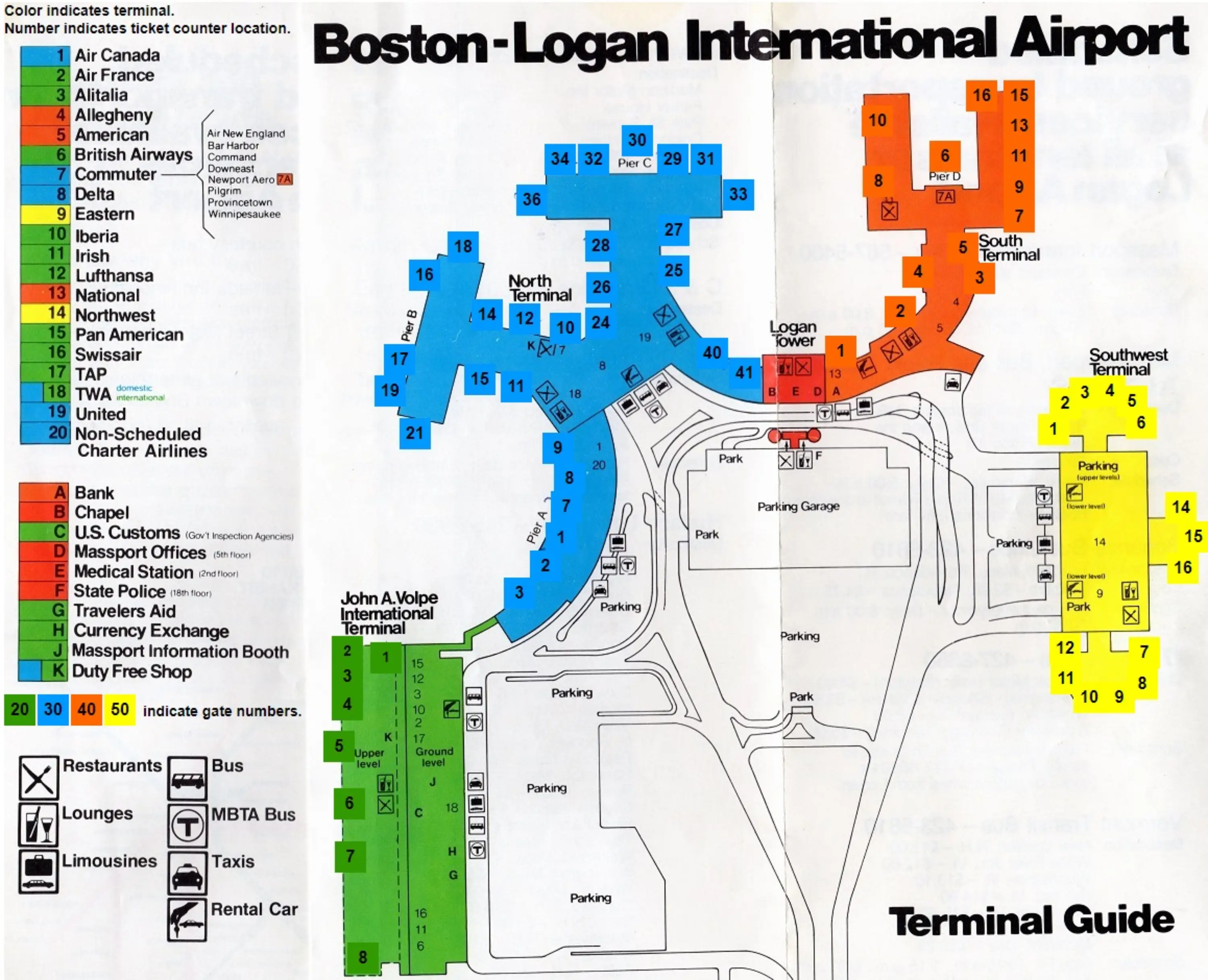
1986 Logan International Airport Map
1974 Logan International Airport Map