Birmingham Airport Map (Most Up-To-Date)
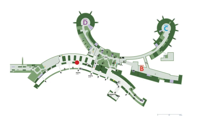
Birmingham Airport (BHX) is a single, elongated terminal formed by merging legacy Terminal 1 and the Eurohub Terminal 2 via the Millennium Link. Landside functions sit mainly on the Ground Floor, while security, departures, and most gates run on the First Floor in a linear left–right layout. The core navigation reality at the Birmingham air hub is a central vertical choke to security and long airside walks to the North Pier (Gates 1–20).
Map Table
| Terminal | Key Airlines | Primary Function | Transfer Mode |
|---|---|---|---|
| Main Terminal Ground Floor | Jet2, TUI, Ryanair, easyJet | check-in, bag drop, arrivals exit | walk, lifts, stairs |
| Main Terminal First Floor | Jet2, TUI, Ryanair, easyJet | security, departures lounge, retail | lifts, stairs, walk |
| North Pier Gates 1–20 | Ryanair, easyJet | far-gate concourse | Millennium Link, moving walkways, walk |
| Forecourt Car Parks | all airlines | set-down, pick-up, shuttles | walk, shuttle bus |
Birmingham Airport Map Strategy
- Treat the main entrance doors as a possible security “start line” in the AM peak; if the queue is downstairs, joining it immediately beats walking to the lifts to “check.”
- Use the central lift/stairs bank as your choke-point marker; if it’s congested, expect pulsed surges upstairs and slower tray induction even with new scanners.
- Neutralize drop-off anxiety by committing early to the correct car park lane; avoid stopping on approach roads and assume the ANPR clock begins at the Premium Set Down threshold.
- Defuse end-to-end timing risk by planning for the longest airside walk (North Pier Gates 1–20) and using rail/Air-Rail as the fallback approach when forecourt roads gridlock.
2026 Birmingham Airport Map + Printable PDF
2026 operations still center on the rebuilt Next-Generation Security layout and its capacity limits at peak. The former central escalator flow is replaced by high-capacity lifts and stairs feeding a single security hall, so queues can backfill down into the check-in level during the morning bank. Landside road enforcement and barrierless ANPR zones remain a major “wrong turn = penalty” stressor.
2026 Birmingham Airport Map Guide
What is the exact physical entry point to the security queue (the first “back of line” location) during morning peak overflow at Birmingham Airport?
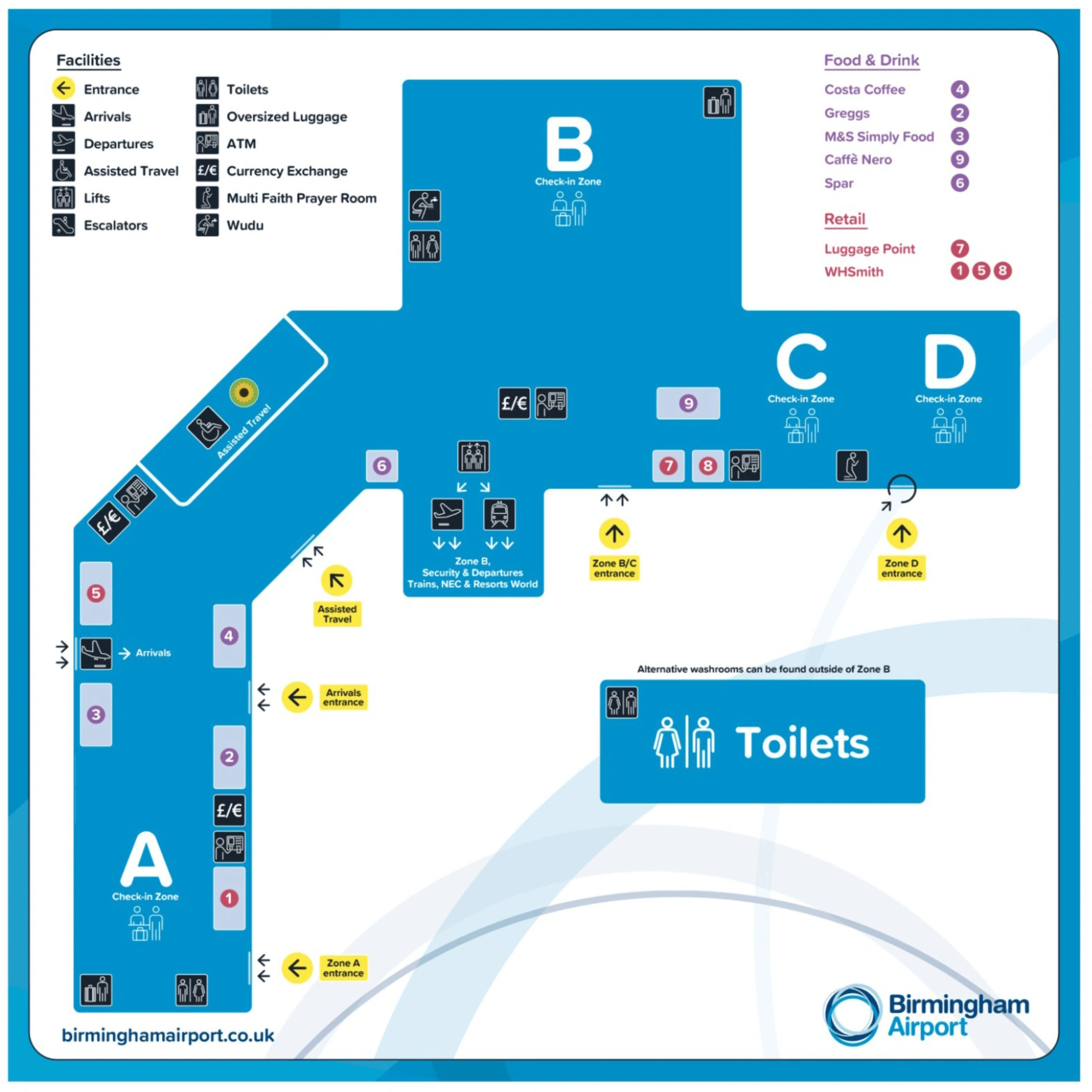
The back of the security line can start at the Ground Floor main terminal entrance doors during morning peak overflow. When the First Floor security hall saturates, the queue is routed down the central stairs/lifts and snakes through the Ground Floor check-in hall, so arriving passengers may find the tail of the line immediately inside the entrance—sometimes spilling onto the pavement by the Premium Set Down frontage.
Queue routing is typically managed to keep the “snake” aligned with the check-in hall’s central circulation, using the vertical-core area as the pressure valve. If you enter and see stanchions and a dense line near the central lift/stairs zone, assume that is the back-of-line; walking past it toward the vertical core usually just brings you back to the same tail after staff re-route you.
Where is the lift/escalator/stairs junction used to access the security level, and what is the exact walking distance from that junction to the security trays/scanners?
The main junction is the central vertical core in the Ground Floor check-in hall where the bank of high-capacity lifts and the primary stairs feed up to the First Floor security hall. This is the practical “valve” point: when security backs up, the queue is held here and routed onto stairs/lifts as space opens upstairs.
From the First Floor lift exit, the walk to the security tray induction and CT scanner lanes is about 20–40 meters, with the trays/scanners directly ahead inside the security hall. If the downstairs queue is active, the effective distance becomes “queue-length dependent,” because the junction itself functions as a pre-queue holding area immediately before the security entrance.
What is the exact boundary of the “drop-off / pick-up” enforcement zone (where ANPR starts/ends) relative to the terminal frontage roads and car park entrances?
The ANPR enforcement boundary starts at the entrance threshold to the Premium Set Down area off Airport Way/Concorde Road, where cameras mark the point-of-no-return into the barrierless paid zone. Because there is no physical barrier, the “start” feels invisible, but the tariff clock begins as soon as your plate is captured crossing into the Premium Set Down footprint.
The paid zone is confined to the Premium Set Down car park circulation lanes and bays, while the approach roads immediately outside it are treated as Red Route no-stopping corridors. The practical rule is that stopping before the ANPR line risks a Red Route PCN, and entering beyond the line starts the paid stay. The mapped identifiers for the capture point are Postcode B26 3QJ and what3words ///shade.hunt.frock.
What is the most direct pedestrian route from Birmingham International rail station to the terminal entrance, and what is the measured walking distance in meters?
The most direct route is the Air-Rail Link from Birmingham International station to the terminal, with a short walk at each end. This is the default station-to-terminal path because it bridges the road/rail gap and drops you directly into the terminal complex.
| Route | Path | Measured distance |
|---|---|---|
| Primary | rail station → Air-Rail Link → terminal (First Floor landing) | short walk + 2-minute ride |
| Backup | rail station → outdoor pedestrian route via internal roads/Bickenhill Lane → terminal frontage | ~1000–1200 m |
The walk-only fallback is physically possible but “hostile” with luggage because it relies on exposed paths and road crossings rather than a continuous indoor bridge. If the Air-Rail is disrupted, the safest practical backup is usually a shuttle/taxi rather than committing to the full 1000–1200 m walk.
Where is the primary baggage reclaim hall located relative to arrivals exit corridors, and which belt positions are closest to the first-arrivals doorway?
The primary baggage reclaim hall is on the Ground Floor immediately after passport control, entered directly from the arrivals exit corridor. The reclaim area is a single consolidated hall serving all inbound flights, so the transition from the one-way arrivals doors into the belts is short and direct.
Belt positions closest to the first-arrivals doorway are typically the first belts encountered upon entering the hall, commonly the lower-numbered belts such as Belt 1 and Belt 2. Belt assignment is dynamic by flight, so “closest belt number” is a proximity cue rather than a guarantee; the reliable map logic is that the first belt(s) you see on entry are the nearest to the corridor from passport control.
What is the exact walking distance from the arrivals immigration/passport exit point to the first baggage belt in the reclaim hall?
Walking distance is under 50 meters from the passport control exit to the first baggage belt at Birmingham Airport. The reclaim hall sits directly beyond the one-way doors from the immigration area, so there is no long connecting corridor segment.
The practical navigation cue is that once you clear the exit from the passport control zone, the first belt is immediately in front of you inside the same ground-floor hall. If you’re meeting others, the “dead walk” is minimal; the main variability after that point is baggage delivery time, not the distance to reach the belts.
From the security exit, what is the longest walking distance to the farthest gate (end-to-end), measured in minutes at normal walking pace?
The longest walk is from the security exit to Gate 1 in the North Pier (Gates 1–20), which typically takes 15–20 minutes at normal pace. This is the end-to-end “gate sprint” risk because it requires clearing the duty-free funnel and then committing to the Millennium Link corridor toward the far end of the pier.
Walking time stretches when the terminal is busy or the moving walkways are out, because the North Pier is reached via a long linear connector before the final pier segment. A useful anchor is the assisted-travel benchmark placing mid-pier gates like Gate 16 about 7 minutes from the main departure lounge area; reaching Gate 1 adds additional pier distance on top of that, pushing the total to the 15–20 minute range.
Where are the first major decision nodes after security (first split to gates/shops/lounge corridors), and how far is each node from the security exit?
The first major decision node is immediately after the mandatory World Duty Free walkthrough, about 50–80 meters from the security exit. This is where passengers effectively choose between the North Pier commitment (Gates 1–20 via the Millennium Link) and the central/south-side concourses (higher-numbered gates and lounge/restaurant corridors).
The second practical decision point appears as you clear the duty-free boundary into the main departures lounge sightlines, where gate-direction signage becomes readable before you fully enter the wider seating/retail area. From this point, the “wrong turn” penalty is time: heading deeper into central shops first and then backtracking for Gates 1–20 can easily add several minutes before you even start the Millennium Link walk.
Where is the Long Stay car park bus pickup point located relative to the terminal entrance, and what is the walking distance from bus drop-off to check-in doors?
The Long Stay bus pickup/drop-off is on the terminal forecourt at the marked bus stop area (commonly Bus Stop D, with operations sometimes using adjacent stops such as G/H). This is the curbside shuttle interface directly outside the terminal frontage rather than inside the car parks.
Walking distance from bus drop-off to the check-in doors is about 110 meters, roughly a 3-minute walk, with the Assisted Travel help desk area acting as a reliable landmark just inside the entrance. If you’re timing a peak-hour arrival, the walking segment is predictable; the variable is shuttle headway and forecourt congestion, not the final 110 m into the doors.
Which terminal frontage road segments concentrate vehicle queues during peak drop-off, and what are the nearest alternative curbside approach points shown on the airport road layout?
Peak queues concentrate on Airport Way and the final approach lanes feeding the Premium Set Down entrance off Concorde Road, where committed traffic merges and drivers hesitate at the paid-zone threshold. The pressure spikes where vehicles sort between Premium Set Down, car parks, and the continuing loop, because missed choices are hard to undo without re-entering enforced zones.
The nearest practical alternative approach is the Car Park 5 “Drop Off” route, which splits off before the final terminal ramp and moves the set-down into a designated lot instead of the frontage lane. From there, the curbside equivalent becomes the terminal-side end of the covered walkway (or the shuttle stop area), trading the tight forecourt merge for a controlled lot entry and a longer pedestrian segment.