Billy Bishop Toronto City Centre Airport Map (Most Up-To-Date)
Billy Bishop Toronto City Airport (YTZ) is a compact, linear island airport just offshore from downtown Toronto, oriented along a single passenger terminal spine fed by the mainland access node at Eireann Quay. The layout is dominated by the tunnel-or-ferry choice, which funnels into an atrium-style check-in and CATSA area immediately above the tunnel escalators. Compared with Toronto’s Pearson mega-hub (YYZ), distances are short, but curb logic and chokepoints are tighter and easier to misread.
Map Table
| Terminal | Key Airlines | Primary Function | Transfer Mode |
|---|---|---|---|
| Single terminal | Porter Airlines, Air Canada | Downtown Toronto short-haul | Pedestrian tunnel, ferry, taxi, rideshare, shuttle |
Billy Bishop Toronto City Airport Map Strategy
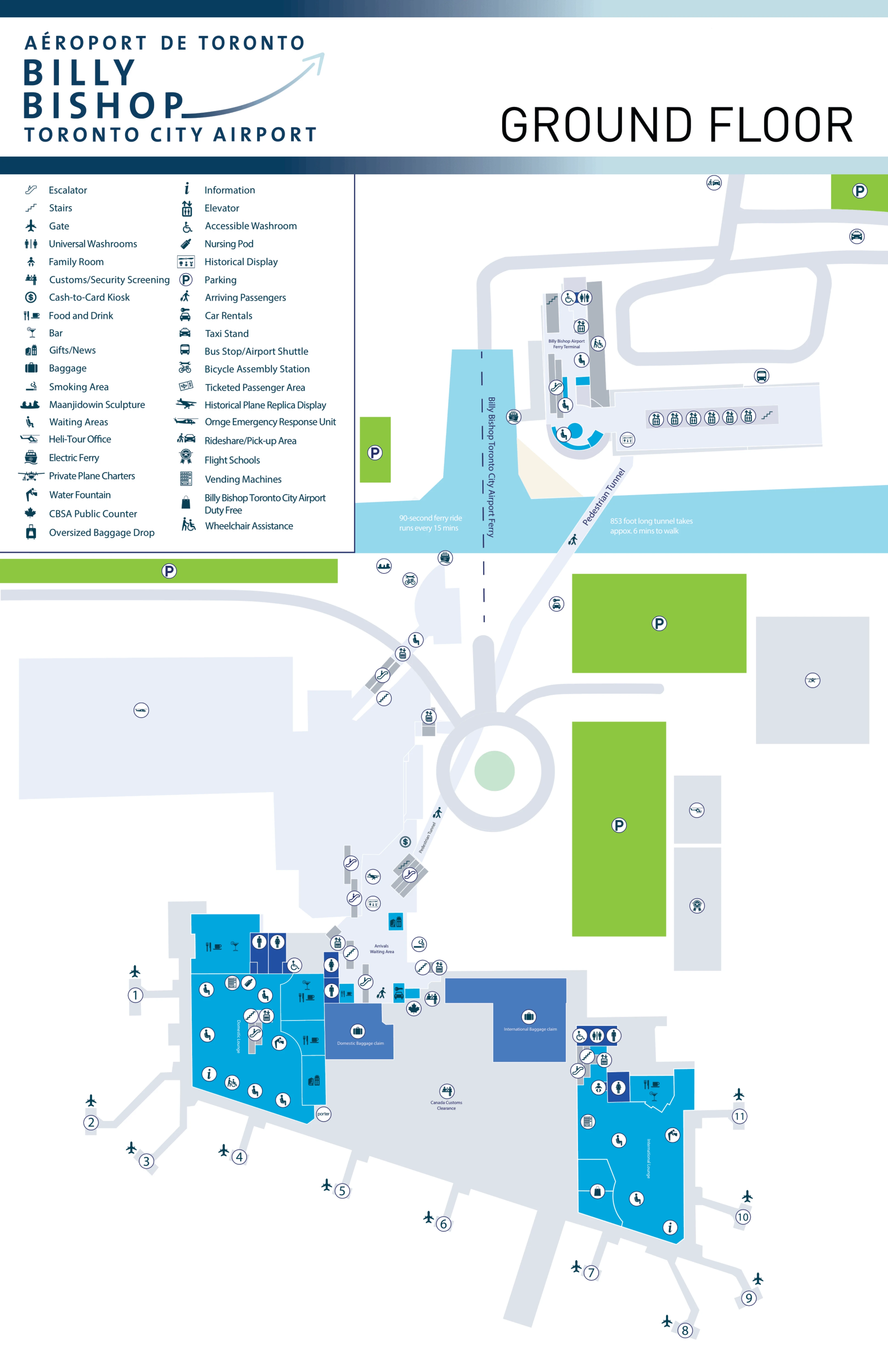
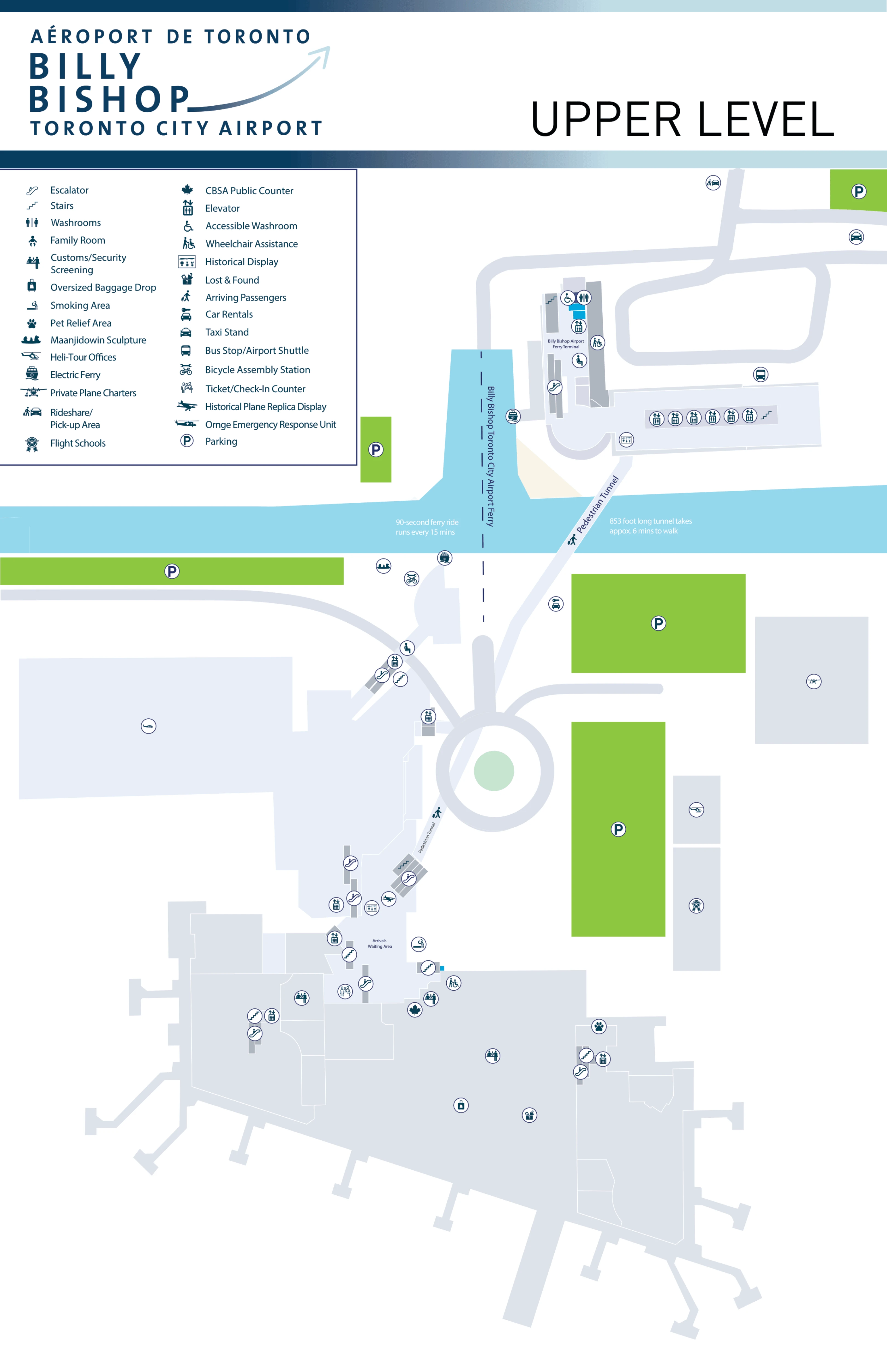
- Treat the mainland ↔ island transition as the primary map decision: plot the Mainland Pavilion entry, the tunnel descent, the 260 m tunnel run, and the island ascent so you know exactly where you emerge on both sides.
- Map curbside logic as two different places: drop-offs at the Mainland Pavilion curb, but many pickups (especially rideshare/private) pushed to the Finger Lanes by Little Norway Park—no “just wait at the main curb” fallback.
- Solve time-risk by marking chokepoints, not just rooms: the island-side escalator/elevator bank as the first bottleneck, then the CATSA entry as the next compression zone with the queue spilling back into the atrium toward check-in and the escalator landing.
- Add disruption constraints directly onto the approach map: limited driver staging, a turning circle with very short wait tolerance, and detour-ready approach paths so you don’t commit to Eireann Quay and have to backtrack.
2026 Billy Bishop Toronto City Centre Airport Map + Printable PDF
Current operations still hinge on the same mainland ↔ island chain: Eireann Quay ground access into the Mainland Pavilion, the 853-ft (260 m) pedestrian tunnel, then the island escalator/elevator ascent into the atrium-style terminal where check-in and CATSA sit side-by-side. The most important 2026 “print” detail is mapping exact curb logic and line start points, because the terminal is small enough that queues can compress and spill into circulation space quickly.
Billy Bishop Toronto City Centre Airport Terminal Map 2026
Billy Bishop Toronto City Centre Airport Ground Floor Map 2026
Billy Bishop Toronto City Centre Airport Upper Level Map 2026
2026 Billy Bishop Toronto City Airport Map Guide
What is the exact walking distance (meters) from the mainland pedestrian-tunnel entrance to the terminal check-in hall?
Walking distance is about 260 meters from the mainland tunnel entrance to the island-side terminal check-in hall (the tunnel’s full horizontal length). The route starts at the Mainland Pavilion’s tunnel descent, continues through the 853-ft (260 m) climate-controlled tunnel with moving walkways, then ends as you rise on the island side into the atrium where the check-in counters are immediately visible. The only added distance beyond 260 m is minimal—check-in sits roughly 10–20 meters from the top of the island escalator landing.
Which street-level landmark/intersection is the closest direct entry point to the pedestrian tunnel (no detours)?
The closest direct street-level entry point is the Mainland Pavilion at the foot of Eireann Quay, beside the ferry ramp. This glass pavilion is the street-to-tunnel gateway: you enter at the pavilion doors, then take the elevator bank down to the tunnel. The easiest “confirm you’re in the right place” landmark is the Billy Bishop statue in the forecourt, with the ferry docking hardware immediately adjacent to the pavilion.
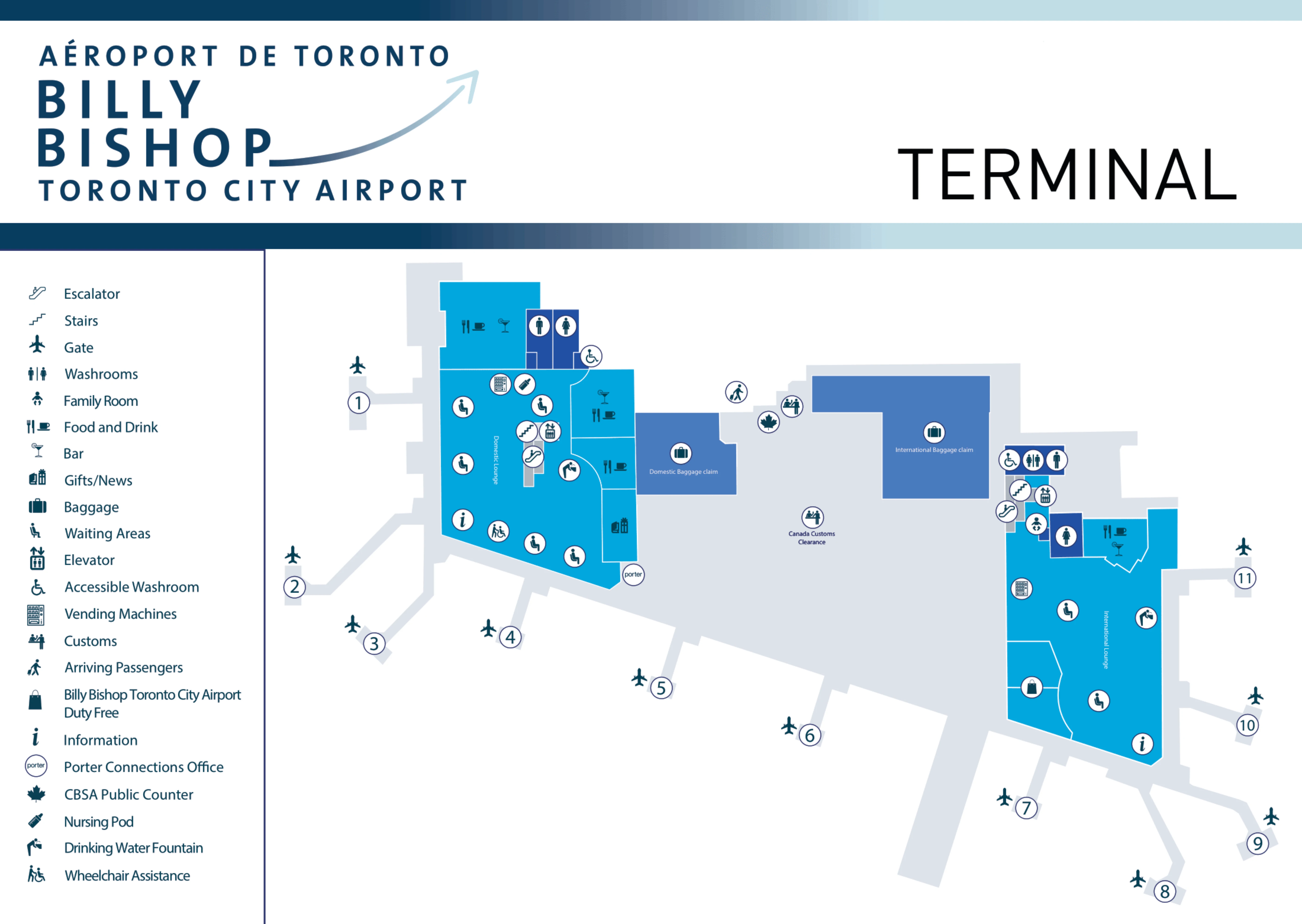
Where is the first choke point after exiting the tunnel into the terminal (the exact corridor/door where people bottleneck)?
The first choke point is the island-side vertical ascent lobby at the tunnel exit, where tunnel foot traffic funnels into the long escalator system and the two-elevator bank up to the Island Atrium. Bottlenecks form at the elevator doors and the escalator loading area because capacity drops from six elevators on the mainland descent to only two elevators on the island ascent. When escalators are down or luggage-heavy surges hit, the queue can back up into the tunnel-side lobby.
What is the exact walking distance (meters) from the tunnel exit inside the terminal to the security screening entry?
Walking distance is under 50 meters from the island-side tunnel exit (top of the long escalator landing into the Island Atrium) to the CATSA security screening entry. The escalator deposits you directly into the same atrium that holds the check-in counter rows, and the CATSA entrance sits adjacent within that hall—no corridor walk. Using a practical landmark, the path runs from the escalator landing across the atrium floor to the CATSA checkpoint entrance.
Where does the security line physically begin (the exact point/rope-start), and which direction does it overflow when busy?
The security line begins at the CATSA checkpoint entrance rope line in the Island Atrium, directly beside the check-in hall circulation space. When it gets busy, the queue overflows backward into the open atrium floor, expanding away from the CATSA entry and curling toward the check-in counter rows and the tunnel escalator landing area. Because the atrium is compact, the overflow typically occupies the main walking space between the escalator landing and the counters rather than disappearing into a separate hallway.
Where is the closest meet-up point landmark immediately after a passenger exits the tunnel on the mainland side?
The closest meet-up point is the Mainland Pavilion curb right outside the tunnel ascent exit, in the forecourt by the Billy Bishop statue. That spot is the first street-level landmark passengers reach after riding the mainland elevators up from the tunnel. For a meet-up that allows brief vehicle presence, the turning circle beside the pavilion is the nearest option, but it’s limited to a very short wait window and is not a reliable holding area.
Where is the best curbside pickup zone relative to the tunnel exit (exact curb/loop/lot), measured by walking distance?
The best pickup zone depends on vehicle type: taxis stage closest at the Taxi Corral to the right of the Mainland Pavilion, while rideshare/private pickups are directed to the Finger Lanes beside Little Norway Park. From the tunnel exit onto the mainland (Pavilion doors), the taxi corral is roughly a ~50 m walk, while the Finger Lanes are about ~150 m away and require walking away from the pavilion forecourt. The critical constraint is that rideshare pickups are not meant to wait at the Pavilion curb.
What is the exact location of short-term parking entry (the correct turn-in point) relative to the terminal/tunnel access?
Short-term/daily parking entry is at 9 Stadium Road, the P2 Daily Park on the mainland side near the Eireann Quay terminus. From that entry, the walk to the Mainland Pavilion (tunnel access point) is roughly 100–200 meters, depending on where you park inside the facility. A common failure mode is routing to “P3 Priority”/2 Eireann Quay listings that can imply ferry-fee or premium handling; 9 Stadium Road is the safest “turn-in” coordinate for standard self-park access to the tunnel.
If street construction blocks the usual approach, what is the mapped alternate vehicle approach route to reach the terminal drop area?
The mapped alternate approach is Lake Shore Blvd W → Fort York Blvd → Dan Leckie Way → Queens Wharf Rd → Housey St → Eireann Quay (Mainland Pavilion drop curb). This detour is designed to bypass the “no southbound Bathurst” constraint during active phases of the Bathurst/Lake Shore work and rejoin the airport approach from the CityPlace side streets. Expect the secondary choke points to be at the Lake Shore & Dan Leckie area and on Queens Wharf Rd, where residential traffic can slow the final approach into Eireann Quay.
Where is the airline check-in counter row located relative to the main entrance (which side/segment of the departures hall)?
The check-in counter rows are in the Island Atrium directly opposite the tunnel escalator landing, visible immediately as you step off the long escalator into the terminal. The counters for Porter and Air Canada sit in the open hall rather than down a corridor, so the “main entrance” reference point is the top of the tunnel ascent: from that landing, you face into the atrium and the counter row is straight ahead within roughly 10–20 meters.
What is the exact walking distance (meters) from security exit to the farthest departure gate used for scheduled flights?
Walking distance is roughly 200–300 meters from the CATSA security exit to the farthest departure gate, translating to under 5 minutes on foot in normal conditions. After screening, the terminal runs as a compact linear pier serving about 11 gates, so you stay on a single main airside path rather than navigating multiple concourses. Using a landmark anchor, you clear CATSA and proceed along the airside pier until the last numbered gate at the far end.
Where is baggage claim located relative to the arrivals exit, and what is the shortest mapped path from baggage claim to the tunnel?
Baggage claim is on the ground level of the island terminal near the arrivals flow, feeding passengers back toward the central atrium circulation. The shortest path runs baggage claim → Island Atrium → descend via escalators/elevators to the tunnel level → walk the 260 m pedestrian tunnel → ascend mainland elevators → exit at the Mainland Pavilion doors. The key navigation anchor is that the tunnel connection is the same central spine used for departures, so you’re always routing back to the atrium/tunnel descent point, not to an exterior curb on the island.
Where is the taxi stand / rideshare pickup point mapped relative to the arrivals exit (which curb/side)?
Taxi pickups are at the Taxi Corral to the right of the Mainland Pavilion (looking toward the lake), while rideshare pickups are in the Finger Lanes beside Little Norway Park. After arriving and taking the tunnel back to the mainland, you exit through the Pavilion doors: taxis are the shorter walk at about ~50 meters, and rideshare requires walking ~150 meters away from the pavilion forecourt toward the park-side lanes. The dealbreaker is that rideshare is not intended to stage at the Pavilion drop-off curb.
Where is the lounge located relative to gates, and what is the walking distance from security exit?
The lounge is immediately to the right after clearing security, located between Door A and the washrooms, so the walking distance from the security exit is effectively near-zero (about 10–30 meters). Because it sits at the entrance of the airside pier, it functions as a central holding point for all gates: you enter airside, turn right by Door A, and you’re at the lounge before committing to the longer walk down the pier.
Where is the closest public restroom to the security entrance (exact location and distance)?
The closest public restroom is the post-security washroom cluster beside Door A, adjacent to the lounge area, within roughly 10–30 meters of the security exit and just beyond the screening threshold. For a pre-security option, the nearest restrooms are in the Island Atrium/check-in hall, a short walk from the CATSA entry point across the same open floor space used by the security queue. The most reliable landmark for the closest unit is Door A immediately after screening.