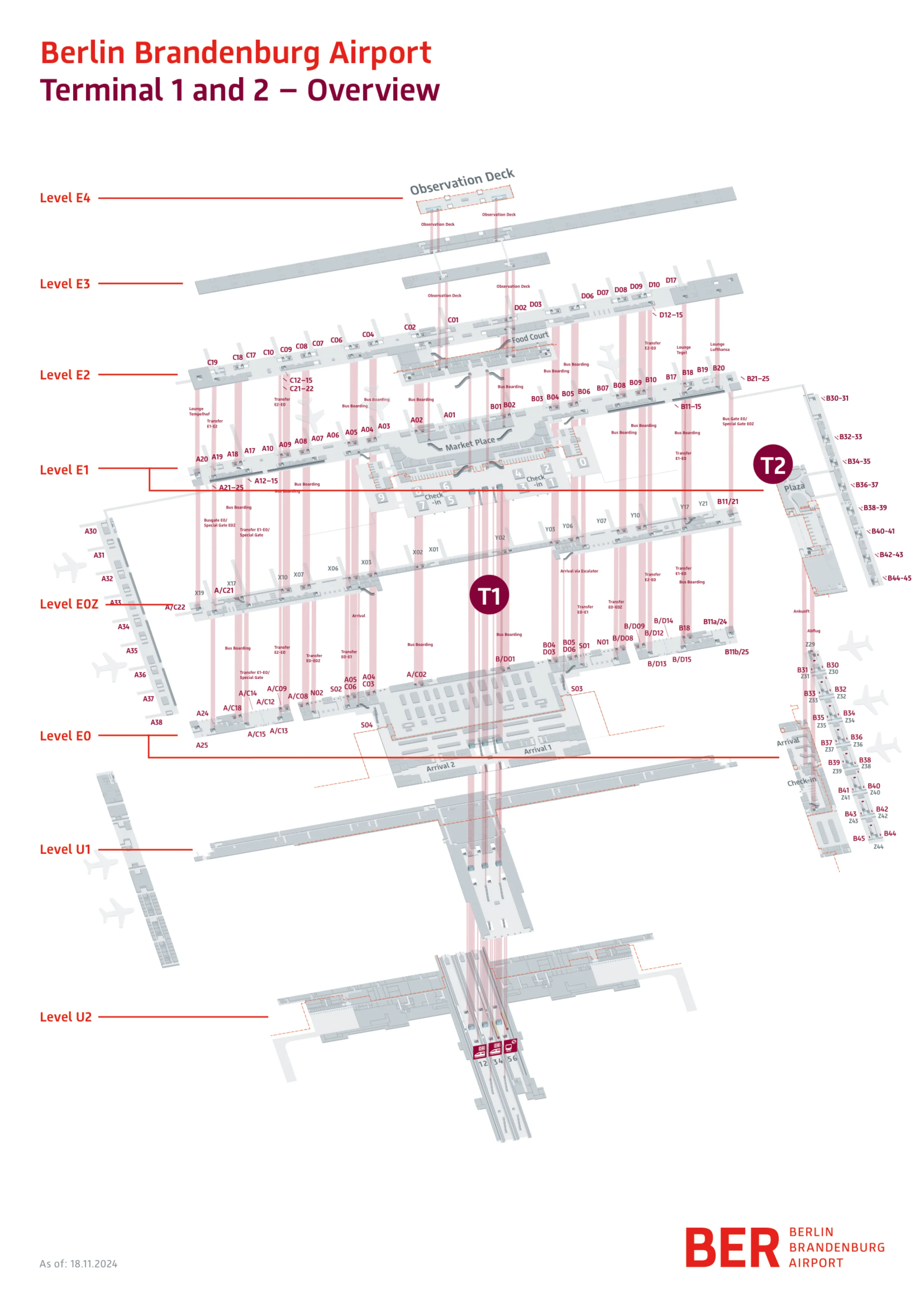
Berlin Brandenburg Airport Map (Most Up-To-Date)
Berlin Brandenburg Airport (BER) is a compact “U-shaped” terminal complex with Terminal 1 as the central spine and Terminal 2 offset to the south. The rail station sits directly underneath Terminal 1 on Level U2, feeding vertical movement up through U1 and E0 to departures on E1. Inside Berlin’s main airport complex, most time loss comes from long pier walks, queue swings at security/passport control, and level changes to reach trains.
Map Table
| Terminal | Key Airlines | Primary Function | Transfer Mode |
|---|---|---|---|
| Terminal 1 (T1) | Lufthansa Group, Eurowings, network carriers | Rail access, main processing, passport control | Vertical core U2→E1 |
| Terminal 2 (T2) | Ryanair, Wizz Air, low-cost mix | LCC check-in, dedicated security (CT) | Landside walk to/from T1 |
| Rail Station (U2) | FEX, S-Bahn, RE/IC | Airport rail injection point | Elevators/escalators U2→E0/E1 |
| T1–T2 Connector | — | Landside terminal link | Sheltered corridor via “Mitte” |
Berlin Brandenburg Airport Map Strategy
- Treat Terminal 2 like a remote annex: plan for the landside corridor through the “Mitte” plaza and assume an ~0.8 km walk to reach Terminal 1 rail access.
- From the rail platforms (U2), prioritize the central elevator banks to jump levels efficiently; escalator flows often force extra stops and bottleneck at U1/E0.
- Reduce security uncertainty by picking a lane on purpose: BER Runway users go to Security Control 2 and enter on the right side next to the Priority access; CT-equipped lanes (often Security 1/5) trade convenience for queue volatility.
- Pad tight connections for two variables at once: long gate-dependent pier walks plus immigration/security staffing swings, then add a buffer for Deutsche Bahn delays before you even start the terminal “triple jump” (U2→U1→E0→E1).
2026 Berlin Brandenburg Airport Map + Printable PDF
Current operations at BER in 2026 still revolve around two predictable friction zones: the forced landside walk between Terminal 2 and Terminal 1 (rail access), and the “layer-cake” vertical climb from rail (U2) to departures security (E1). Security throughput remains variable due to mixed screening tech and lane choice, with BER Runway time-slots adding predictability.
2026 Berlin Brandenburg Airport Map Guide
What is the exact walking distance from Terminal 2 arrivals exit to the Terminal 1 rail-station entrance (Level U2 access point)?
Walking distance is approximately 0.8 km (800 meters) from the Terminal 2 arrivals exit to the Terminal 1 rail-station access for Level U2. The route runs landside: you exit Terminal 2 at arrivals level (E0), follow the covered “sheltered corridor” north through the “Mitte” plaza, then enter Terminal 1 on Level E0 and continue to the central vertical core that drops to U2. Typical walk time is about 7–12 minutes before any elevator/escalator waiting.
Where is the Terminal 2 departures security checkpoint entrance located relative to the main T2 check-in hall (which side/zone)?
The Terminal 2 security checkpoint entrance is directly adjacent to the Terminal 2 check-in hall, reached immediately after the E0 check-in area as you flow toward departures. From the main T2 public hall (check-in/bag drop on Level E0), follow the departures stream toward the compact security processing zone that sits right off the check-in footprint rather than being separated by a long landside corridor. If the security area is backing up, the spillover you’ll see is into the same check-in-side hall because T2’s footprint is compressed.
What is the longest walking route from the farthest Terminal 1 gate area to passport control/immigration (identify the endpoints on the map)?
The longest walk to Terminal 1 passport control is from the extreme ends of Pier A or Pier B—typically Gate A38 or Gate B45—back to the centralized Passport Control at the main terminal hub (near the “Market Place” core). That end-to-core trek is roughly 800–1,000 meters and commonly takes about 10–15 minutes of pure walking before any immigration queuing.
| Endpoint gate area (start) | Route spine (what you traverse) | Passport control endpoint (finish) | Distance | Walk time |
|---|---|---|---|---|
| Gate A38 (Pier A far tip) | North extension → main Pier A → inward to central hub | Central Passport Control near “Market Place” | ~800–1,000 m | ~10–15 min |
| Gate B45 (Pier B far tip) | South extension → main Pier B → inward to central hub | Central Passport Control near “Market Place” | ~800–1,000 m | ~10–15 min |
Where is the primary elevator bank that connects Terminal 1 arrivals level to the rail station level (U2) (exact map position/landmark)?
The primary elevator bank is the central set of elevators aligned with the middle of the “Flughafen BER” rail platforms on Level U2, directly under Terminal 1’s central hall. On the Terminal 1 side, it corresponds to the central Arrivals Hall (Level E0) node where DB branding, ticket machines, and the main escalator/elevator descent cluster sits—use that central core to drop straight down toward U2 rather than drifting to outer escalators.
Which signed corridor/path is the official landside connection from Terminal 2 into Terminal 1 (name the connection + where it enters T1)?
The official landside connection is the sheltered corridor through the “Mitte” plaza that links Terminal 2 to Terminal 1 on arrivals level (E0). From Terminal 2 landside, you follow Terminal 1 / Rail / Train wayfinding into the covered, surface-level walkway that runs north across the central plaza zone. It brings you to the Terminal 1 facade and feeds straight into Terminal 1’s public Arrivals Hall on Level E0, near the central hall circulation node where passengers then turn inward for the vertical core down to U2 (rail) or up to E1 (departures/security).
Where is the entry point/lane for pre-booked security time slots located inside Terminal 1 security (exact checkpoint/queue start)?
The BER Runway pre-booked time-slot entry starts at Terminal 1, Level E1, Security Control 2, on the right-hand side of that checkpoint. It sits immediately beside the Priority Lane access at Security 2.
From the Terminal 1 check-in hall (E1), walk to the security controls and aim specifically for the “Security Control 2” sign cluster rather than joining the shortest-looking line. At the Security 2 frontage, keep to the right edge of the checkpoint face; the Runway entrance is the right-side queue start next to the Priority entry point, where you scan to validate your slot before merging into screening.
What is the exact walking distance from the rail station platform level (U2) to the Terminal 1 main departures security entrance?
Walking distance is effectively 0 km because the rail station sits directly below Terminal 1; the movement is almost entirely vertical from Level U2 up to departures security on Level E1. The practical “distance” is the three-level ascent (U2 → U1 → E0 → E1), which can take just a few minutes when elevators/escalators are clear, but becomes variable when escalator flows bottleneck or elevator queues form after a train arrival pulse.
| Start (U2) | Vertical path | Finish (E1) | Typical time | Main volatility driver |
|---|---|---|---|---|
| Central platforms at “Flughafen BER” station | U2 → U1 → E0 → E1 (or elevator bypass) | T1 departures security zone (E1) | ~3–8 min | elevator wait + escalator congestion |
Where are the Terminal 2 airline check-in/bag drop counters positioned relative to T2 security (closest counter block to the checkpoint)?
The Terminal 2 check-in and bag drop counters are on Level E0, with the security intake immediately adjacent off the same compact public hall footprint. The closest counter block is the check-in row that faces the departures flow toward the dedicated T2 security control area, so you finish bag drop and then move straight into the security approach without changing buildings or crossing a separate landside concourse. Because T2 is compressed, any queue buildup at security tends to appear right off the check-in-side approach rather than down a long corridor.
What is the shortest mapped route from Terminal 1 baggage claim to the S-Bahn/FEX access escalators (identify the exact escalator/escalator bank)?
The shortest route runs from Terminal 1 baggage claim to the central escalator bank in the public Arrivals Hall (E0) that descends toward rail (U1/U2). After collecting bags, exit through the customs Green Gate into the public hall, then angle toward the middle of the hall where the DB/S-Bahn sign cluster and ticket-machine area sits; the main escalators down are immediately beside that central signage node.
- Exit baggage reclaim into the public Arrivals Hall via the Green Gate.
- Walk to the center of the Arrivals Hall toward the DB logo / green “S” wayfinding cluster.
- Use the central escalator bank next to the ticket machines to go down E0 → U1 → U2 for S-Bahn/FEX platforms.
Where are the main wayfinding sign clusters that indicate “Terminal 2” once you are inside Terminal 1 landside (exact nodes/intersections on the map)?
The main “Terminal 2” sign clusters are at Terminal 1, Level E0 (Arrivals), at the exits that push you out of the building toward the plaza connector. The key nodes are the Arrivals Hall’s outward-facing decision points—where you choose “outside/plaza” rather than going up to E1—because the landside T1–T2 connector starts from E0.
- Level E0 Arrivals Hall, near the main outward exits toward the “Mitte” plaza (the point where you leave T1 landside).
- The E0 central hall circulation node where passengers orient using rail/bus/terminal signage, then follow “Terminal 2” toward the covered walkway.
Archive Berlin Brandenburg Airport Map
Below are all historical map versions for Berlin Brandenburg Airport. Each year includes the official map available for that period, presented as both WebP and PDF.
2024-2026 Berlin Brandenburg Airport Map (Official 2024 Edition)