Benito Juárez International Airport Terminal 2 Map (Most Up-To-Date)
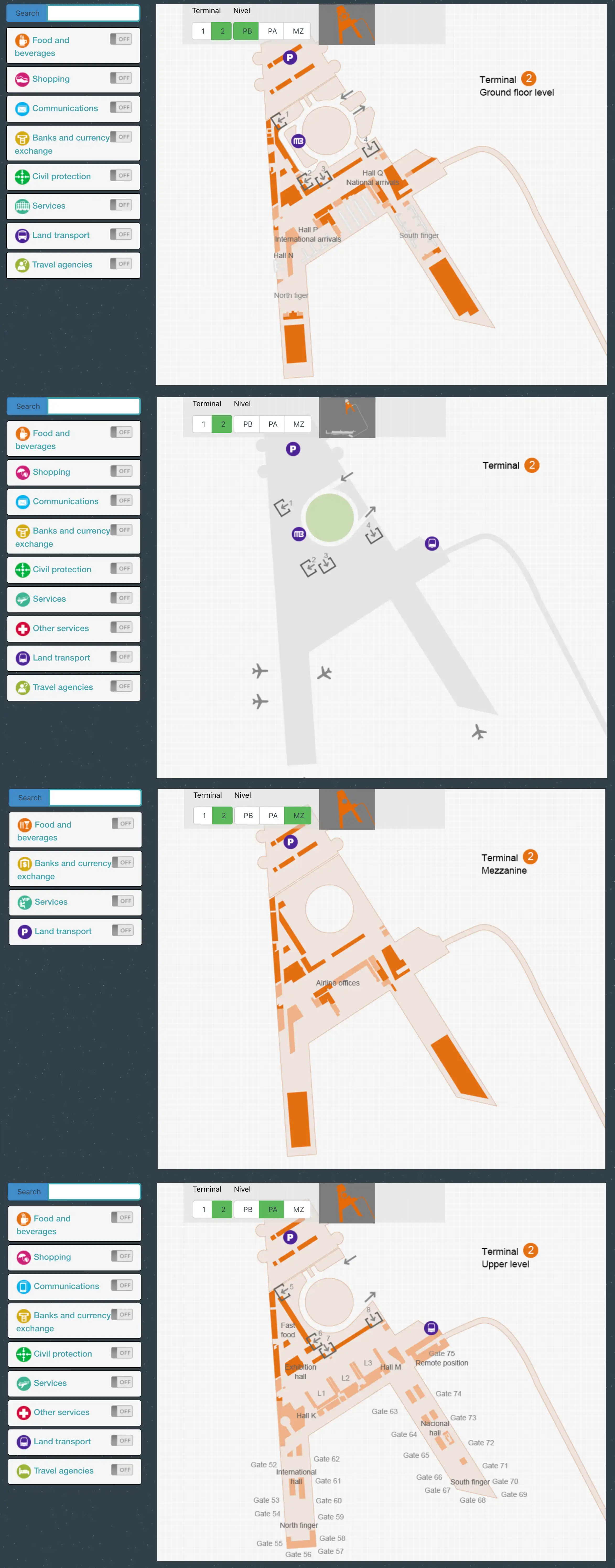
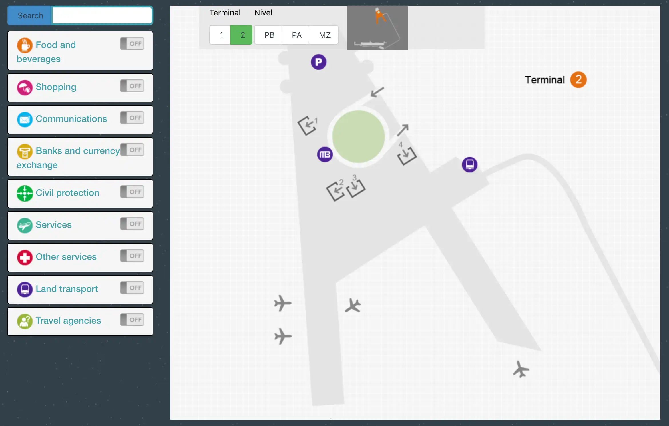
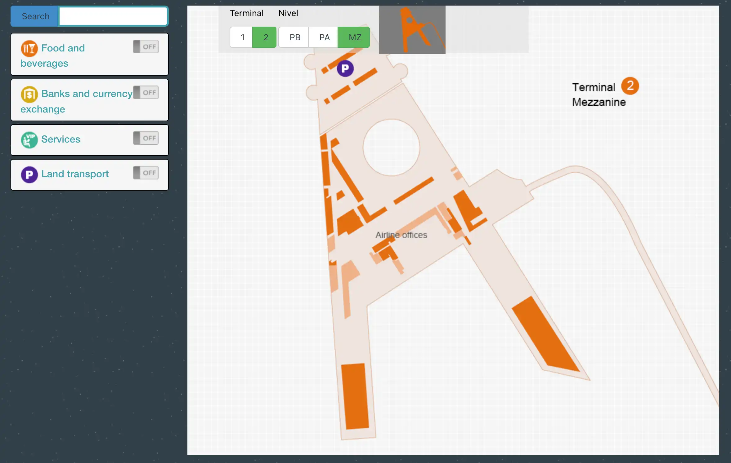
Benito Juárez International Airport Terminal 2 (MEX T2) is a hub-and-spoke terminal with a central post-security retail atrium that feeds two long airside arms (Hall K north, Hall M south) and a farther Pier L extension past the Hall M hub. The building is stacked: departures/security above, arrivals/doors/ground transport below. Within Mexico City’s primary aviation hub, most navigation success comes from identifying the post-security “split” early and committing to the correct hall fast.
Map Table
| Level | Airside halls | Landside doors | Key transfers |
|---|---|---|---|
| Upper | Security exit atrium | — | Aerotrén access-controlled |
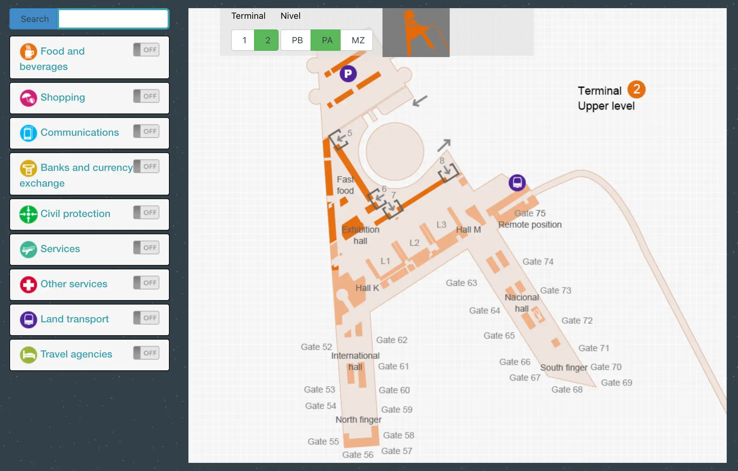
| Upper | Hall K (52–62) | — | — |
| Upper | Hall M (63–75) | — | Hall M → Pier L junction |
| Upper | Pier L (75–81) | — | far-gate walk |
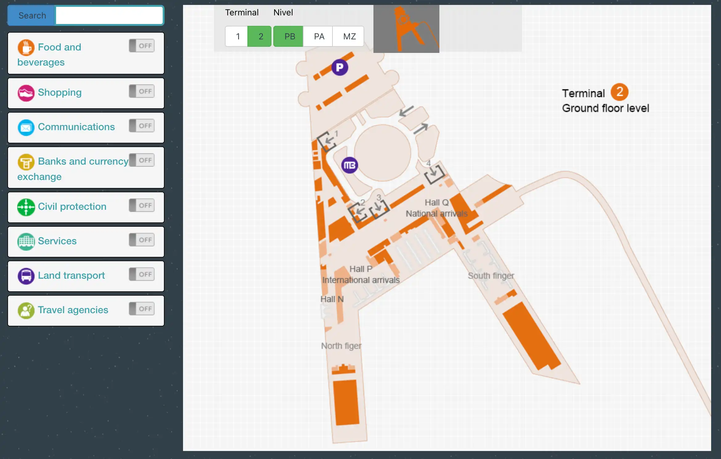
| Ground | — | Puerta 4 shuttle | T2↔T1 landside bus |
| Ground | — | Puerta 2 Metrobus | Line 4 access |
| Ground | — | Puerta 1 parking-side pickup | domestic lot interface |
Benito Juárez International Airport Terminal 2 Map Strategy
- Treat “M” as a corridor command, not a gate: pass the duty-free/Starbucks retail core and commit toward Gates 63–75 immediately, even if the numeric gate isn’t posted yet.
- Build a far-gate buffer by default: Hall M + Pier L can turn into a 15–25 minute walk when FIDS posts late and the corridor clogs at travelator choke points.
- Assume vertical surprises for remote stands: if the screen shows bus/remote indicators, target the Gate 75 area and look for the down-route to bus boarding instead of waiting at an upstairs podium.
- Transfers and pickups need exact nodes: Aerotrén is boarding-pass controlled with specific interior access points, Puerta 4 is the shuttle anchor, and ride-hail works only by walking out toward the avenue via the roundabout/parking geometry.
2026 Benito Juárez International Airport Terminal 2 Map + Printable PDF
Terminal 2 continues to run as the Aeroméxico-heavy hub with the long Hall M walk and the Pier L extension still defining “end-of-terminal” timing in 2026. Remote-stand operations remain a practical reality, so the hidden vertical drop to bus boarding is still a common failure point. Aerotrén access rules and curbside ride-hail restrictions keep transfers from being “intuitive,” even when distances are short.
Benito Juárez International Airport Terminal 2 Map 2025
Benito Juárez International Airport Terminal 2 Ground Floor Map 2025
Benito Juárez International Airport Terminal 2 Upper Level Map 2025
Benito Juárez International Airport Terminal 2 Mezzanine Map 2025
2026 Benito Juárez International Airport Terminal 2 Map Guide
What is the exact map location of the first (and/or only) signage decision point that directs passengers from post-security toward Hall/Concourse “M” in Terminal 2?
The first decisive Hall/Concourse “M” direction is the overhead sign bank immediately outside the main Upper Level security exit, before the duty-free walkthrough fully absorbs the corridor. It’s the moment you leave the X-ray/body-scanner zone and enter the high-ceiling post-security retail atrium.
The sign you’re looking for sits above the central aisle that runs past the duty-free frontage and the first big post-security FIDS cluster. Use the duty-free entrance as your near-field anchor: the “Gates 63–75” (Hall M) arrowing appears right as the atrium opens, before you drift deeper into the Starbucks/dining cluster (Starbucks, Cinnabon, Gong Cha, Italianni’s, Tacos El Pastor). If you walk past this retail node without seeing “63–75,” you’re already losing time to Hall M.
What is the exact walking distance (meters) from the primary security exit to the entrance doors of Hall/Concourse “M” in Terminal 2?
The walking distance is about 300–350 meters from the main Upper Level security exit to the start/entrance of Hall M at the Gate 63 corridor mouth. This is the point where the open retail atrium narrows into the dedicated southbound gate hallway.
That path runs straight through the post-security commercial core: you exit security into the atrium, pass the duty-free walkthrough edge, then continue beyond the high-visibility café/quick-service cluster (Starbucks and neighboring outlets) until the corridor geometry tightens and the first Hall M gate area begins. If you instead benchmark to the Hall M “hub” area around Gate 75 (where the corridor feels like it “ends” before Pier L), the distance is closer to ~800 meters.
What is the exact walking time from the main Terminal 2 security exit to the farthest commonly-used gate cluster (the “end-of-terminal” sprint scenario)?
Walking time is about 15–20 minutes from the main post-security security exit to the far end of Pier L (around Gate 81) in a typical “sprint scenario.” The time expands because the route includes the retail-core drift zone plus Hall M’s long linear corridor before the Pier L extension.
From security, you move through the duty-free/Starbucks retail node toward Hall M (Gates 63–75), then continue to the Hall M hub near Gate 75 where Pier L branches, and finally push down the narrower Pier L section to the terminus gates (75–81). Congestion at the moving-walkway entry/exit points and stop-and-check behavior at FIDS screens are the usual time thieves, so planning 20–25 minutes is the safer operational buffer when gate posting happens late.
Where is the exact bus-boarding point inside Terminal 2 for passengers assigned to a remote stand / bus-to-aircraft operation?
The bus-boarding point is on the Ground Level (Planta Baja), reached by going down the escalators near the Gate 75 node at the end of Hall M. This is the vertical “drop” that catches people who arrive at an upstairs gate area expecting a jetbridge.
Remote-stand flows typically present as an upstairs waiting/gate number in the 63–75 range, but the actual boarding action shifts down a level. Navigate airside toward Hall M using the “Gates 63–75” signage, continue until you reach the Gate 75 area (the Hall M hub), then look for the downward signage that references bus departures (often shown as “Salidas Autobús” or a bus icon). The escalator bank there is the practical landmark: if you can see the Gate 75 seating zone and the down escalators, you’re at the correct descent vector.
Where is the exact Terminal 2 Aerotrén entrance (level + landmark) that passengers must reach for the T2 → T1 transfer?
The Aerotrén entrance is on the Upper Level (Level 2), inside the terminal interior near the Hall M side, by the domestic departures zone (often referenced around Sala L3 / the domestic corridor). It is not a curbside feature; it’s a controlled entry point that sits deep in the departures-level circulation.
Use Hall M–side wayfinding as your landmark logic: from the main departures level, follow signs for the Aerotrén / Terminal 1 connection and keep to the Hall M/domestic-departures side rather than drifting into the central retail atrium. The practical “dealbreaker” landmark is the staffed/controlled access point (turnstiles/security presence): if you don’t have a valid boarding pass for a same-day connection, you’ll be stopped there and must use the landside inter-terminal bus instead.
What is the shortest indoor route from Terminal 2 arrivals to the inter-terminal shuttle pickup at Puerta 4 (turn-by-turn via map landmarks)?
The shortest indoor route is a straight, ground-level walk inside the public Arrivals Hall from the customs/baggage-claim exit to the glass doors marked Puerta 4. It’s typically under 100 meters because the arrivals corridor runs parallel to the curb and the doors are sequenced in order.
Exit the secured arrivals processing area into the public arrivals hall, then align yourself with the numbered door markers along the glass frontage. Walk parallel to the curbside roadway (do not go upstairs) and follow signs for inter-terminal transport until you reach Puerta 4. Use the door-number plaques above the exits as your primary confirmation anchors; Puerta 4 is also the shared pickup zone where you’ll see shuttle/hotel-transport congregation rather than individual curbside meets.
What is the exact pedestrian route from Terminal 2 arrivals exit to the ride-hail “avenue” pickup point that requires going around the roundabout toward parking?
The pedestrian route is a forced off-terminal walk from Ground Level arrivals doors (commonly Puerta 2 or Puerta 3) out toward the parking/NH Hotel direction, continuing around the terminal loop/roundabout until you reach Avenida Fuerza Aérea Mexicana for app pickup. Curbside pickup directly in front of the terminal is not the reliable endpoint.
Exit the arrivals hall through Puerta 2 or Puerta 3 to the curbside lanes, then cross away from the terminal frontage (past the authorized-taxi traffic) onto the pedestrian sidewalk that tracks toward the parking structure/NH Hotel side of the loop. Stay on the outer edge of the roundabout geometry rather than hugging the terminal doors, and keep walking until the roadway opens into the larger arterial where ride-hail pins typically land (Avenida Fuerza Aérea Mexicana). Expect roughly 300–500 meters and 5–8 minutes with luggage, with the “parking/NH Hotel” direction acting as your navigation anchor.
Where are the primary flight-information display screens in Terminal 2 that show gate assignments (one pre-security location, one post-security location) on the map?
The primary pre-security gate-assignment screens are the large monitor banks above and around the check-in islands and at the entrances to the security-queue maze on the departures level. The primary post-security screens are the FIDS monitor cluster positioned immediately at the Upper Level security exit, before passengers disperse into the duty-free/retail atrium.
Pre-security, use the check-in hall as your anchor: stand facing the check-in counters and look up to the overhead boards that cover multiple airline rows, plus the screens mounted at the mouth of the security lanes where lines begin to braid. Post-security, use the security-exit “ejection point” as your anchor: the first FIDS bank is placed directly in front of you as you enter the high-ceiling commercial core, and it’s the last clean moment to confirm whether you’re heading Hall K (52–62) or Hall M (63–75 / Pier L).
What is the exact walking distance from the main post-security food/retail core to the farthest gate pier area that travelers describe as “out of the way”?
The walking distance is about 1.1–1.2 kilometers from the main post-security food/retail core (the duty-free/Starbucks node after security) to the far end of Pier L around Gate 81. This is the “out of the way” stretch that creates missed-boardings when gate posting happens late.
Use the post-security retail atrium as the origin: start at the Starbucks/duty-free cluster where the first Hall M signage appears, then continue down Hall M toward the Gate 75 hub, and finally push through the Pier L extension to the terminus gates (75–81). The Gate 75 junction is the key distance marker—once you’re there, you still have roughly another 350–400 meters to reach the farthest Pier L gates.
What is the exact map location of the Metrobus access point reachable from Terminal 2 (the closest passenger exit-to-stop path)?
The Metrobus access point is at Puerta 2 (Door 2) on the Ground Level arrivals frontage, at the curbside stop for Metrobus Line 4. This is the closest “exit-to-stop” path because the platform is directly outside the numbered door sequence.
Inside arrivals, orient to the glass exit doors and follow the door numbering to Puerta 2, then step outside to the curb where Metrobus Line 4 signage and the distinct red ticket/card machines mark the stop. The landmark confirmation is the vending machine cluster at the curb (not inside the terminal), since Metrobus requires pre-payment with the mobility card rather than paying onboard. If you reach Puerta 4’s shuttle congregation, you’ve walked too far down the frontage.
Where is the exact map location of Terminal 2 Door/Puerta 1 pickup adjacent to the parking structure (the commonly referenced “easy pickup” door)?
Puerta 1 is at the far end of the Ground Level door sequence on the arrivals side, positioned closest to the domestic parking structure interface and commonly used for “easier” pickups away from the densest curb activity. It sits opposite the flow concentration you’ll see near the international arrivals exits.
From inside the public arrivals hall, follow the door numbering down to Puerta 1, staying along the glass-front corridor that parallels the curb. The parking-structure adjacency is the key landmark: Puerta 1 is the door that feels physically “pulled” toward the domestic parking access rather than the central shuttle/taxi congregation zones. If you’re standing at Puerta 2’s Metrobus curb markers or Puerta 4’s inter-terminal shuttle pickup, Puerta 1 is further along the same frontage in the direction of domestic parking.


