Benito Juárez International Airport Terminal 1 Map (Most Up-To-Date)
Terminal 1 is a long, linear terminal with two dominant stacked levels: Ground (arrivals, baggage, curbside transport) and Level 1 (departures, check-in halls, security, airside concourse) within Mexico City’s primary airport complex. The stress comes from its “strip” geometry—decision points are spread far apart, and the international side stretches into a satellite pier where a late gate post can turn into a full-length sprint.
Map Table
| Level | Primary Areas | High-Impact Nodes | Long-Walk Exposure |
|---|---|---|---|
| Ground (PB) | Arrivals, baggage, customs, curb | Door 7 bus stop, Door 8–10 intl exits | Landside corridor, Door-to-door walks |
| Level 1 | Check-in halls, security, airside | Checkpoint G/J, post-security FIDS | Gates 29–36 satellite connector |
| Airside spine | Retail core, main concourse | Gate 19 hub, connector “tunnel” | Worst-case far-gate run |
Benito Juárez International Airport Terminal 1 Map Strategy
- Treat Door 7 as a precision waypoint: ground level curb outside Puerta 7, with multiple red buses nearby—verify “Terminal 2 / Transporte interterminal” before boarding.
- Assume the longest walk the moment you clear security: if your flight is international and gate assignment is pending, hold near post-security display banks, not deep in the satellite corridor.
- Remote-stand risk = vertical + timing risk: if your boarding pass hints at “posición/remota,” move early toward the bus-gate descent areas instead of waiting for a final call.
- Self-transfer math must include a full re-entry loop: customs exit → escalators/elevators to Level 1 → check-in/bag drop → security again, then budget the worst-case corridor walk.
2026 Benito Juárez International Airport Terminal 1 Map + Printable PDF
Current operations still behave like a linear “time trap”: gate info can appear late, security lanes can bottleneck fast, and the far end of the international corridor (satellite gates) punishes anyone who waits in the central food/retail core too long. For T1↔T2 transfers, plan around the Door 7 landside bus as the map-verifiable default, with Aerotrén treated as conditional access.
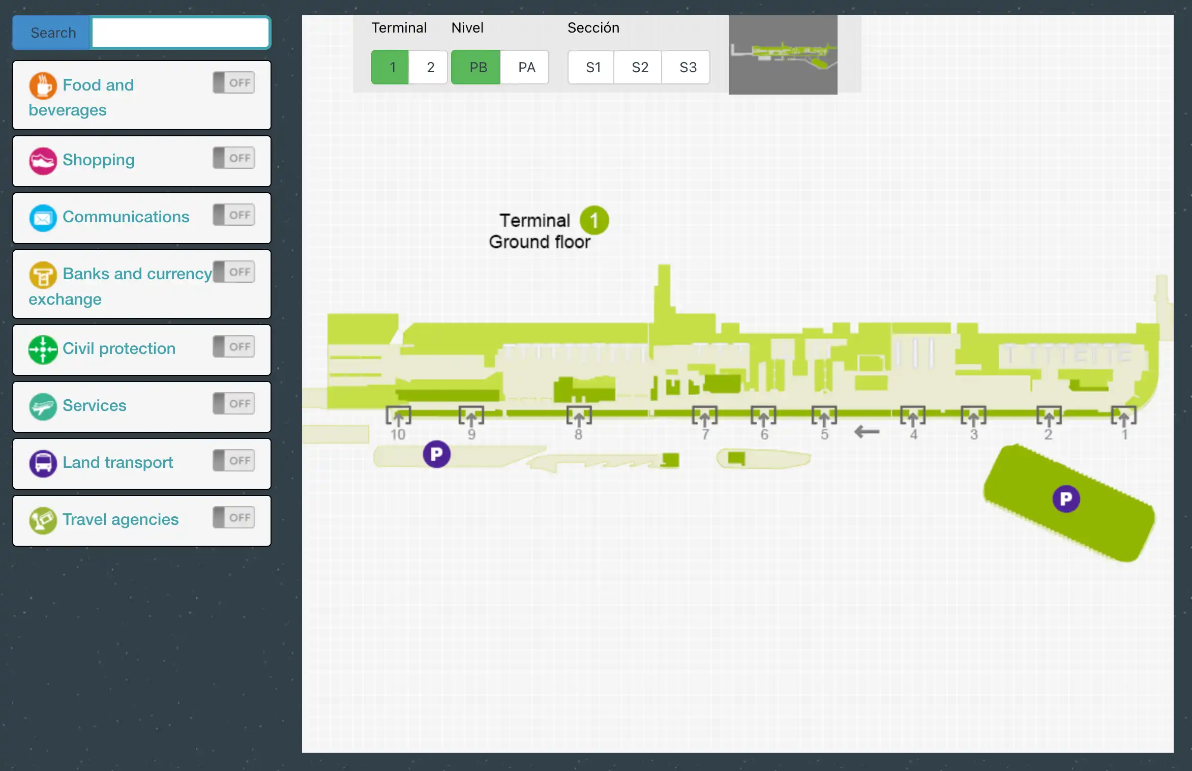
Benito Juárez International Airport Terminal 1 Ground Floor Map 2025
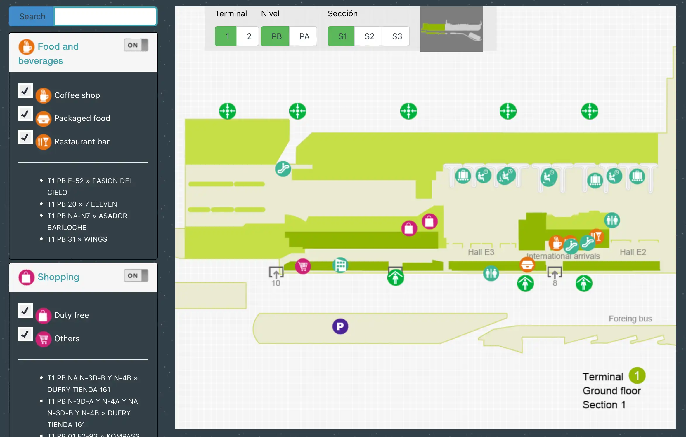
Benito Juárez International Airport Terminal 1 Ground Floor Section 1 Map 2025
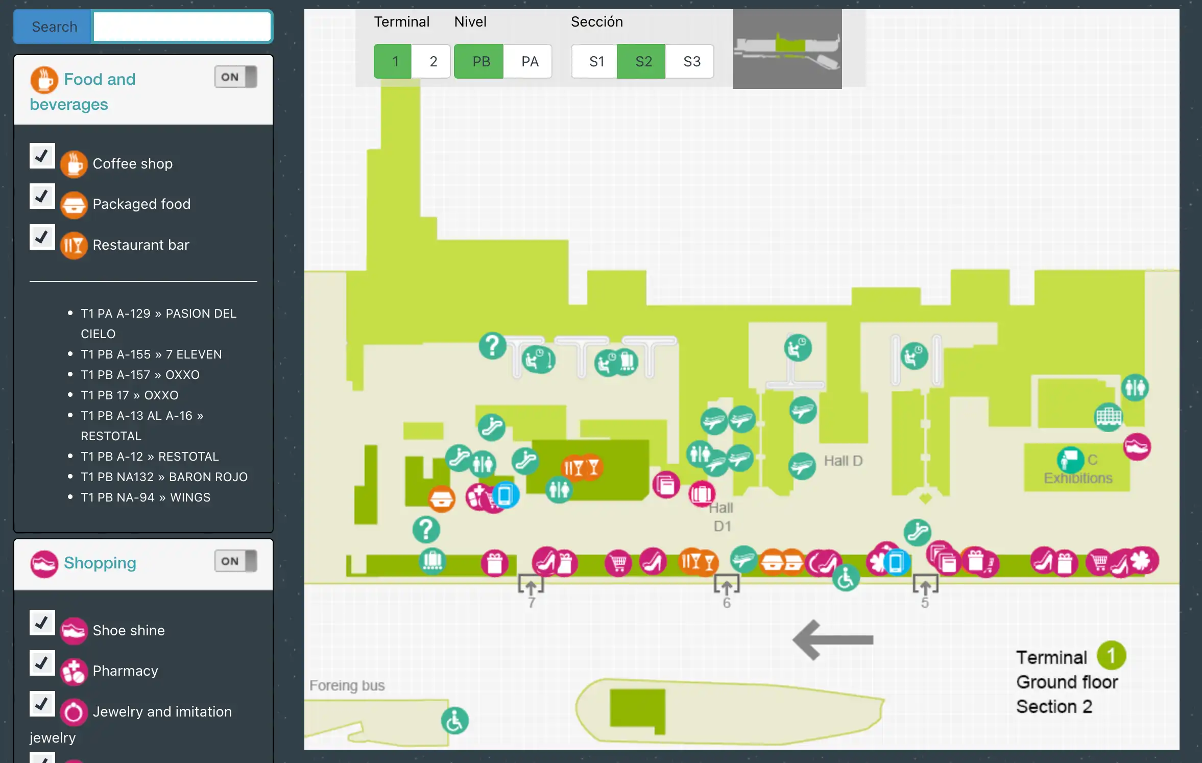
Benito Juárez International Airport Terminal 1 Ground Floor Section 2 Map 2025
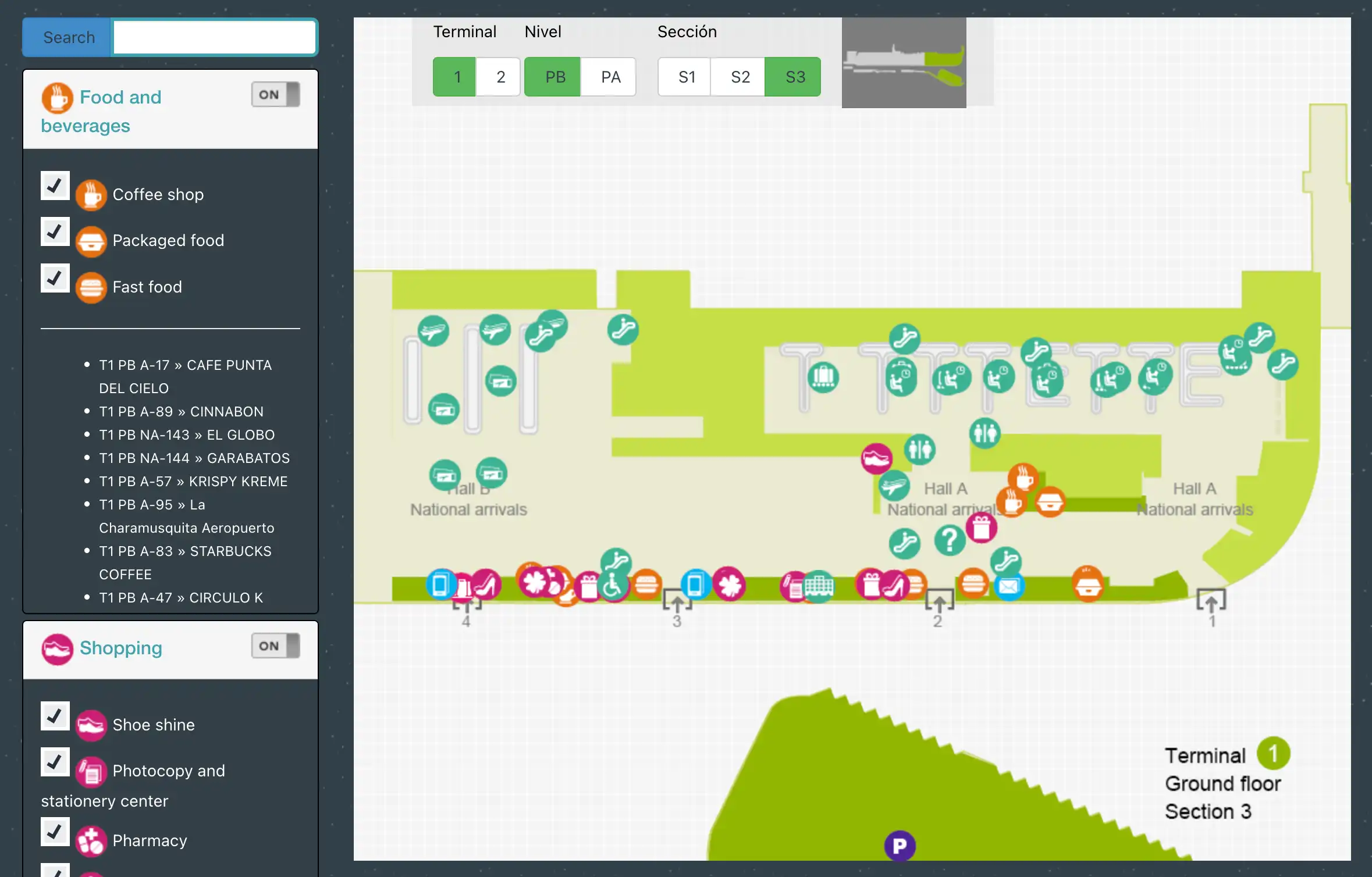
Benito Juárez International Airport Terminal 1 Ground Floor Section 3 Map 2025
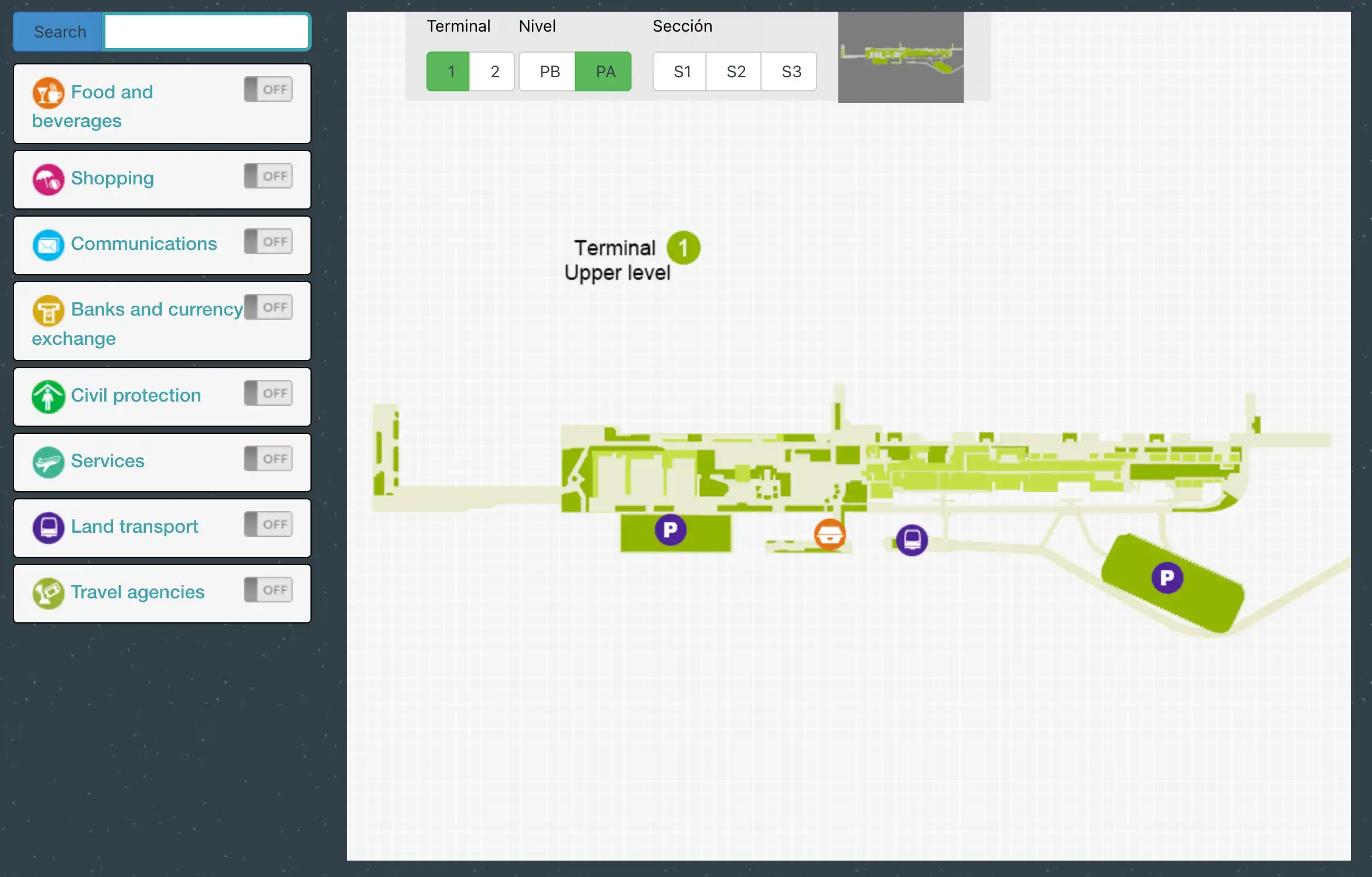
Benito Juárez International Airport Terminal 1 Upper Floor Map 2025
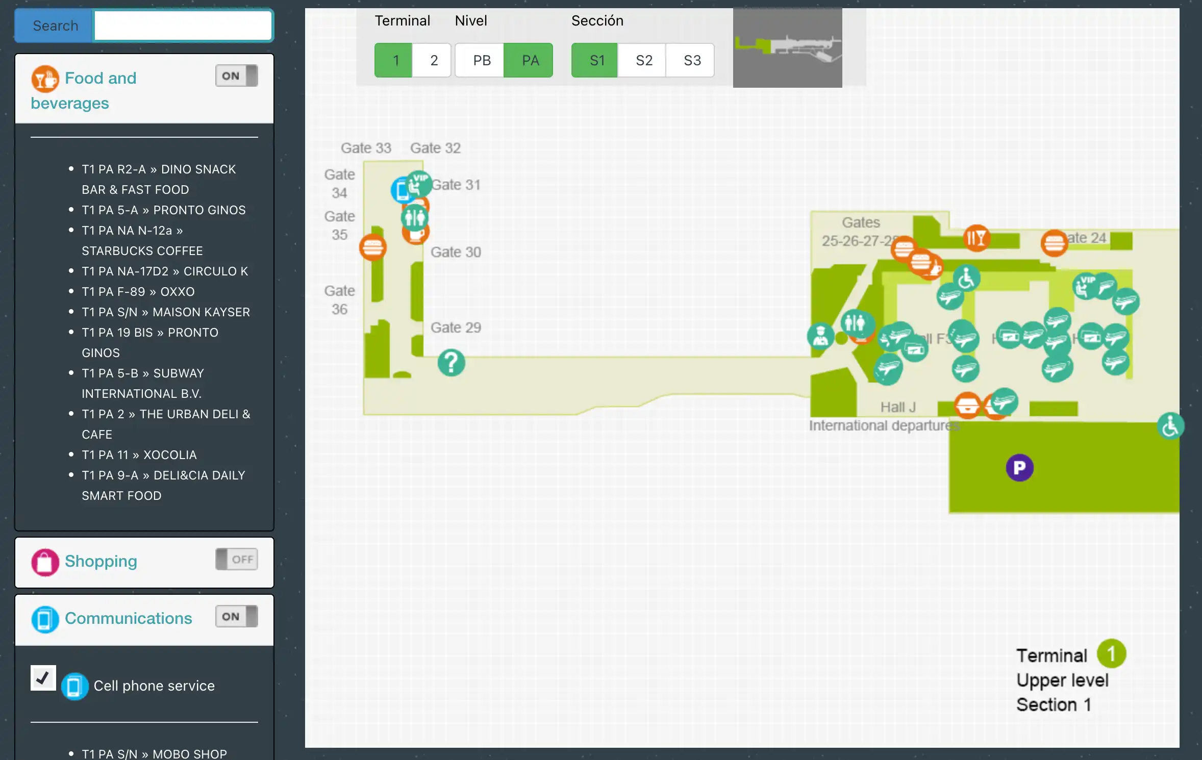
Benito Juárez International Airport Terminal 1 Upper Floor Section 1 Map 2025
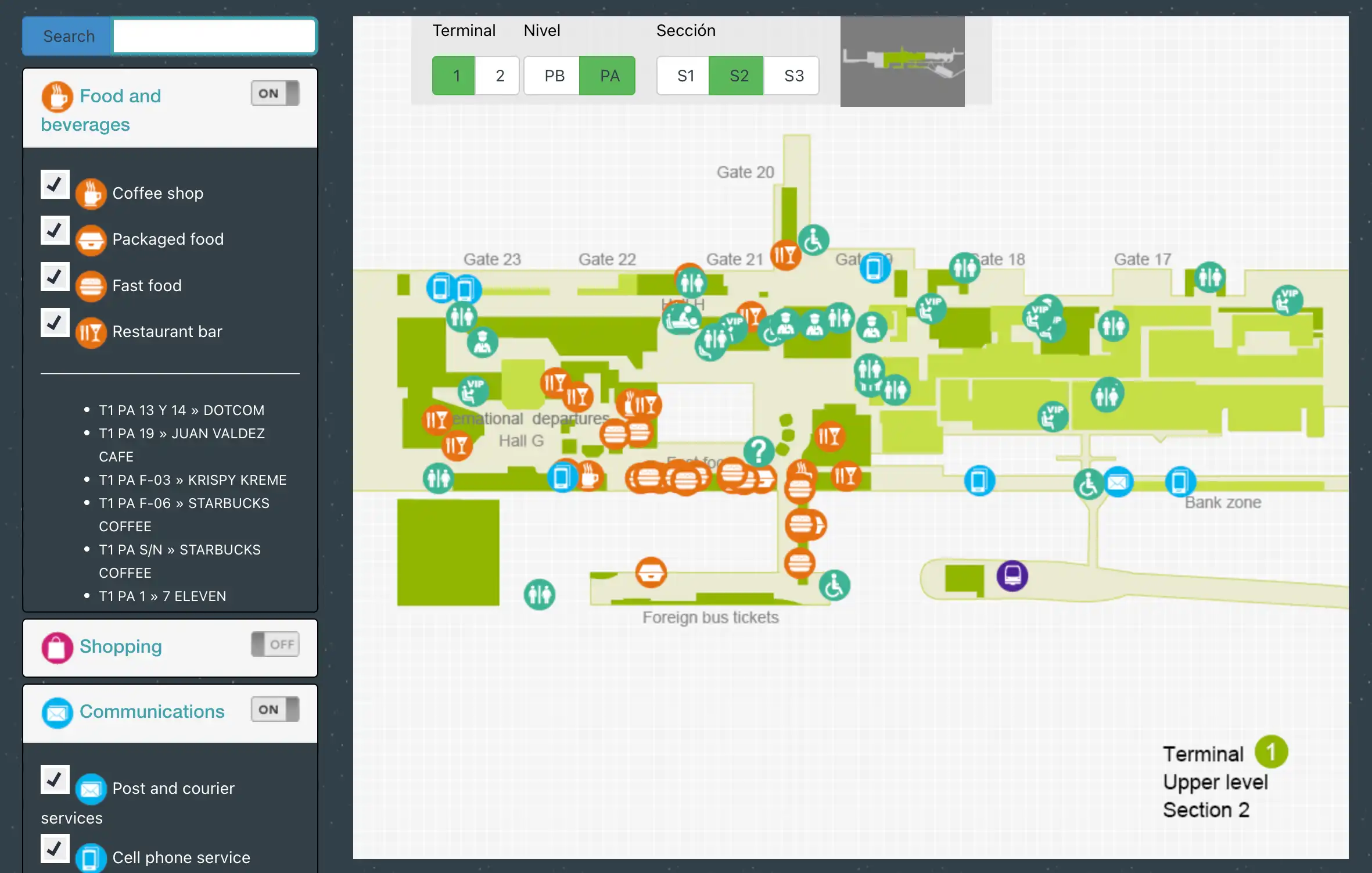
Benito Juárez International Airport Terminal 1 Upper Floor Section 2 Map 2025
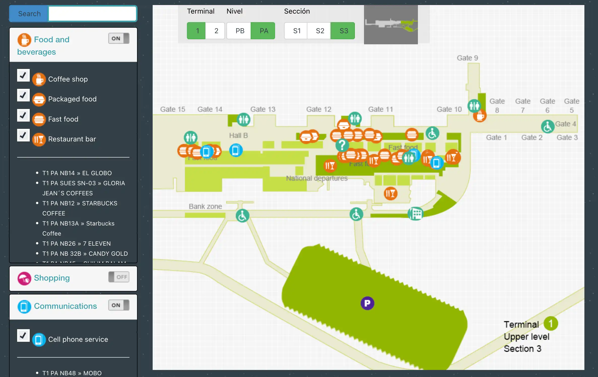
Benito Juárez International Airport Terminal 1 Upper Floor Section 3 Map 2025
2026 Benito Juárez International Airport Terminal 1 Map Guide
What is the exact on-map location of the free inter-terminal bus stop at Terminal 1 Door 7?
The inter-terminal bus stop is curbside on Ground Level (Nivel PB) directly outside Terminal 1 Puerta 7 (Door 7) on the central international-side frontage.
Door 7 sits in the middle landside curb zone between the international exits commonly labeled Puerta 8 and Puerta 9, and it’s the same curb line used by multiple bus services. On the map, anchor it as “Puerta 7 / Door 7” on arrivals/transport level, not the upper departures hall above it. The correct boarding point is the street-facing curb immediately outside the sliding doors at Door 7, where “Transporte interterminal” signage often shares space with Metrobús Line 4 stop markings—so the vehicle destination text (Terminal 2) matters more than the generic red-bus look.
What is the exact walking route and distance from Terminal 1 international arrivals exit to Door 7 (inter-terminal bus pickup)?
Walking takes about 3–5 minutes and covers roughly 100–150 meters from the typical international arrivals exit area to Door 7.
From the international arrivals customs exit on Ground Level (the public arrivals hall near the Puerta 8–9 zone), stay on the same level and follow the landside corridor toward Puerta 7, keeping the curbside doors on your outside shoulder. If you emerge closer to Puerta 9, you’re walking “west” along the terminal frontage toward the more central doors; if you emerge closer to Puerta 8, the walk is shorter and more direct. The Door 7 bus pickup is the curb immediately outside the Puerta 7 sliding doors—do not go upstairs to the long-distance bus counters above this area.
What is the exact walking distance from Terminal 1 main security to the farthest end of the departures corridor (worst-case gate walk)?
Walking is roughly 900–1,000 meters (about 15–20 minutes with luggage and crowd friction) from the main international security area to the farthest satellite gates.
The worst-case path starts just after the international security complex (commonly the Checkpoint G/J side) near the post-security retail core around the Gate 19 decision hub. Continue along the airside concourse past the mid-gates toward the connector walkway (“tunnel”) that links the main building to the satellite pier, then keep going to the end of the satellite concourse at Gate 36. The pinch point is the connector segment—moving walkways may be present but aren’t reliable—so the practical time risk is higher than the straight-line distance suggests.
Where is the bus-boarding point for remote stands (“posición” / bus gates) in Terminal 1, and what is the walking time from the departures hall/concourse used for departures?
Remote-stand boarding happens at airside bus-gate holding areas that require a descent from the departures concourse down to the tarmac bus level, so a “gate” can mean a bus lounge rather than a jet bridge.
The typical pattern is: clear security into the airside commercial hub (duty-free/food court core), then follow signs to the assigned gate where the path drops via stairs/escalators to a lower boarding level used for apron buses. In Terminal 1 this is most often anchored around the lower-level access points near the early/mid gate zones (commonly referenced around Gate 4/7 areas airside, and sometimes around Gate 22/23 corridors depending on the operation). From the central post-security core, the walk to the descent point is usually 5–10 minutes; add 10–15 minutes of bus-cycle waiting plus a 5–15 minute apron ride, which is why arriving at the “gate” exactly at boarding time is already late for a remote stand.
Where are the primary flight-info display banks (that show gate assignments) located in Terminal 1 departures, and which one is closest to the far-gate corridor?
The most reliable gate-assignment screens are clustered at the departures decision nodes before and immediately after security, and the closest “last good” bank before the far-gate run is just post-security near the duty-free/food-court hub around Gate 19.
SIMPLE LIST (Bullets)
- Departures landside, Level 1: large FIDS banks at the entrances to the main check-in hall zones (commonly aligned with F1/F2/F3), where you confirm counter area and any initial gate posting.
- Immediately post-security (international side): major screen banks at the exit of the primary checkpoints (G/J area), where late gate postings often first appear.
- Airside commercial core near Gate 19: the last dense cluster before committing to the long walk toward Gates 25–28 and the satellite connector; this is the closest major bank to the far-gate corridor.
- Satellite zone (Gates 29–36): screens exist but information density drops in the connector segment, creating an “information dark” stretch mid-walk.
How many security screening checkpoints serve Terminal 1 departures, and which Door/Entry points feed each checkpoint (mapped)?
Terminal 1 departures use multiple security checkpoints split by wing, with the international side primarily funneled through Checkpoints G and J and the domestic side using western checkpoints aligned to the A/B/D hall areas.
| Checkpoint (Airside Entry) | Primary Wing | Typical Landside Feed | Map Anchors passengers can follow |
|---|---|---|---|
| G | International | Level 1 check-in hall cluster (F-side) | Hall F check-in zone → Checkpoint G |
| J | International (overflow/alternate) | International departures wing beyond the retail/food hub | Follow international wing signage past the core → Checkpoint J |
| A/B | Domestic | Western check-in / domestic hall frontage | Domestic hall zone → nearest A/B checkpoint |
| D | Mixed/central domestic access + Aerotrén adjacency | Central/western departures hall | Hall D zone (near Aerotrén direction) → Checkpoint D |
Checkpoint choice becomes a time trap because the airside concourse is technically connected but punishingly long; entering the wrong side can force a corrective walk that burns 15–20 minutes before you even start the far-gate corridor.
What is the exact route from Terminal 1 customs exit back to the correct departures level + security entrance for a self-transfer (mapped re-entry path)?
No sterile transfer exists in Terminal 1 for self-transfers, so you must exit customs to landside and re-enter departures via escalators/elevators up to Level 1, then pass security again.
From the customs exit on Ground Level (public arrivals hall), move away from the curbside crowd and immediately target vertical circulation cores located near the connectors between the central halls (D/E/F zone) rather than walking deep along the curb. Go up to Level 1 (Salidas) and reorient to your check-in hall area (international typically aligns with the F-side counters; domestic aligns west). If you need to re-check bags, do it before committing to security; then enter the nearest appropriate checkpoint for your wing (international via G or J, domestic via the A/B/D side). The critical failure mode is re-emerging upstairs at the wrong hall and walking the terminal length before you even join the security line.
What are the exact rideshare pickup zones (Door numbers/level) for Terminal 1, and what is the shortest walking route from arrivals to that zone?
Rideshare pickup is functionally Ground Level curbside at Terminal 1, but the “Door number” shown in apps often behaves like a reference point rather than a guaranteed legal pickup spot.
| Arrival Exit Anchor | Closest Door Zone used in practice | Level | Shortest physical walk | Common operational reality |
|---|---|---|---|---|
| International arrivals customs exit | Puerta 9–10 curb | Ground (PB) | <50 m to the curb doors | Driver may ask you to shift to a less-policed curb/median or farther frontage |
| Central international frontage | Puerta 7–8 area | Ground (PB) | short walk along the curb line | Sometimes easier sync than 9–10 due to congestion |
| Domestic side / west wing | Puerta 1 area | Ground (PB) | walk west along the landside corridor | Often calmer curb; used as a fallback meetup |
If you’re coming from international arrivals, the simplest on-foot route is: exit customs → stay on Ground Level → walk directly out to the curb at the nearest Puerta zone (9/10 if you’re at the far international end, or drift toward 7/8 if pickup is chaotic), then coordinate the exact curb lane/side with the driver before you stop walking.
From the Metro “Terminal Aérea” station, which exit yields the shortest, simplest on-foot route to the Terminal 1 entrance, and what is the measured walking distance?
The “Aeropuerto” (Airport) exit is the shortest, simplest route, with a roughly 200–300 meter walk to Terminal 1’s nearest entrance area around Puerta 1.
Use the station exit signed for the airport/terminal frontage and avoid the alternative exit that drops you toward Boulevard Puerto Aéreo / hotel-side streets, which can strand you on the wrong side of fast traffic. After taking the correct exit, the route is a straight exterior sidewalk run that parallels the Terminal 1 façade until the first major sliding-door entrance zone appears. The distance is short on paper but has built-in friction: stairs out of the station, uneven pavement, and exposure to weather and curbside congestion, which makes it feel longer for travelers with heavy luggage.
Along the Terminal 1 long departures corridor, where are the restroom clusters located, and what is the maximum distance between consecutive restroom points?
Restrooms cluster at the check-in halls and the post-security commercial core, with the longest “thin” stretch occurring around the connector segment between the main concourse and the satellite gates.
SIMPLE LIST (Bullets)
- Landside departures level: restroom clusters near the main check-in hall zones (the F-side counters and adjacent hall entrances).
- Immediately post-security: restrooms near the duty-free/food-court hub around the Gate 19 decision area.
- Main airside concourse (mid-gates): additional restrooms appear intermittently through the Gate 19–24 zone.
- Satellite building (Gates 29–36): a restroom core exists once you reach the satellite concourse.
The maximum gap is typically about 200–300 meters with no obvious restroom access while you’re in the connector walk segment heading to the satellite, which is why it’s smart to stop near the Gate 19 hub before committing to the far-gate run.