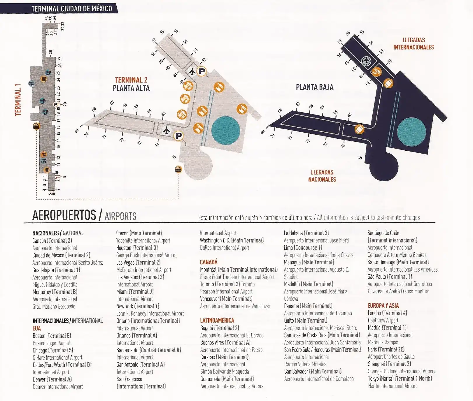
Benito Juárez International Airport Map (Most Up-To-Date)
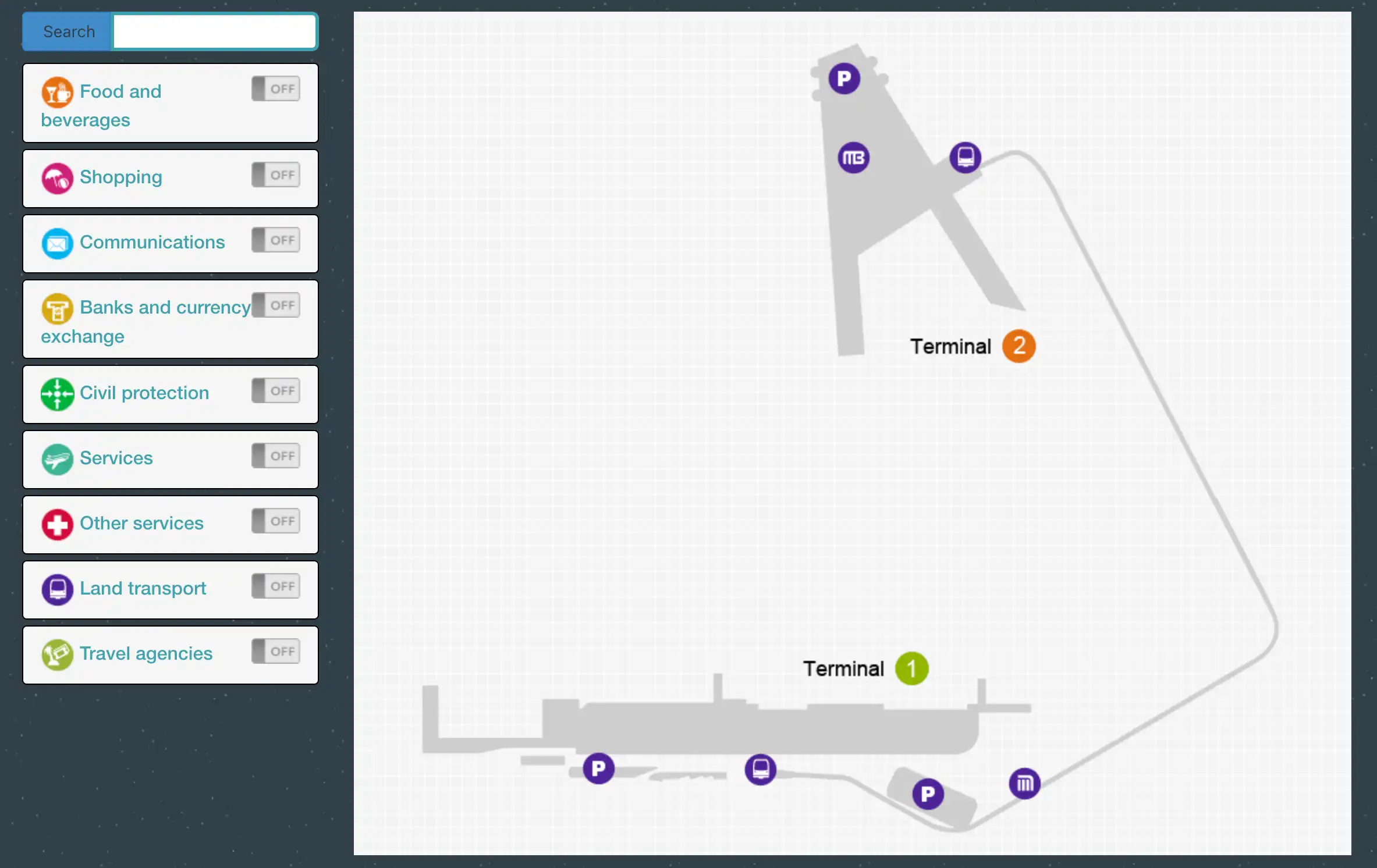
Benito Juárez International Airport functions as two disconnected terminal “islands” within Mexico City’s main aviation gateway: Terminal 1 is a long east–west spine with extended walks, while Terminal 2 is more compact but split vertically (arrivals below, departures above). The terminals sit roughly 3 km apart across active runways, so the map’s main job is reducing transfer friction—especially when Aerotrén access fails and a landside move triggers re-screening and congestion.
Map Table
| Terminal | Key Airlines | Primary Function | Transfer Mode |
|---|---|---|---|
| Terminal 1 | Star Alliance, oneworld, Volaris | long linear corridors, international halls E–F | Aerotrén (eligible), Red Bus (Door 6) |
| Terminal 2 | Aeroméxico, SkyTeam, Delta | vertical bottlenecks, domestic hub | Aerotrén (eligible), Red Bus (Door 4) |
Benito Juárez International Airport Map Strategy
- Treat Terminal 1 ↔ Terminal 2 as a “connection risk event”: confirm Aerotrén eligibility (same-day boarding pass), know the backup Red Bus doors (T1 Door 6, T2 Door 4), and assume periodic outages (including overnight windows) can force landside moves.
- Plan for re-screening as the default: Aerotrén arrival at T1 does not equal airside gate access, so budget time to reach the correct security filter (international security near Hall F3/Hall G at the east end).
- Worst-case walking is the silent killer: Terminal 1’s international flow can turn into a 900 m trek to the Satellite gate cluster, so gate-change awareness matters as much as speed.
- Pre-map your stress points: Terminal 1 official taxi pay-first kiosks near Doors 9–10 for international flow, Terminal 2 Metrobús at Door 2, and the long westbound corridor to Metro “Terminal Aérea” access from Terminal 1 (Hall A side).
2026 Benito Juárez International Airport Map + Printable PDF
Tight connections at MEX still hinge on one question: can you use Aerotrén airside, or will you be pushed landside into queues, traffic, and re-screening. Terminal 1’s east-end international zones (F/G/Satellite) amplify worst-case walking time, while Terminal 2 compresses movement into escalator/elevator choke points that can stall transfers during peak banks in 2026.
2026 Benito Juárez International Airport Map Guide
What is the exact walking distance (meters) from Aerotren Terminal 1 platform to the American Airlines check-in desks in Terminal 1?
Walking distance is about 400–450 meters from the Aerotrén Terminal 1 platform at Puente de Pilotos (Hall D) to the American Airlines check-in counters in Hall F3.
The route runs straight along the upper Departures level, moving east through the mid-terminal commercial corridor. From the Aerotrén bridge exit into Sala D, keep the airfield/windows side as your left reference and continue past Sala D1, then the Sala E stretch (E1–E3), then into Sala F (F1–F2) until you reach Sala F3 where American Airlines check-in is clustered. Congestion around the Sala E food/retail zone can add time even though the meter distance stays the same.
Where is the Terminal 1 security re-screening checkpoint you must use after arriving from Terminal 2 via Aerotren (exact map position / level)?
Re-screening happens at a Terminal 1 security checkpoint on the upper Departures level, and for most international departures the critical access point is the Hall G / Sala G security entrance at the east end of Terminal 1.
After the Aerotrén drops you landside near Puente de Pilotos into Sala D, walk east toward Sala F3 check-in. The international security filter you want is positioned adjacent to Hall F3 and feeds directly into the international duty-free corridor that leads toward the main international gates and the Satellite connector. A practical landmark is the lateral move from American Airlines’ Hall F3 counters to the nearby Sala G “Filtro de Seguridad” entry.
What is the exact walking distance (meters) from Terminal 2 domestic arrivals exit to the Aerotren Terminal 2 station entrance?
Walking distance is about 250–300 meters from the Terminal 2 domestic arrivals exit (ground level, Sala L area) to the Aerotrén station entrance (upper level, Sala M end).
You exit into the domestic arrivals flow on Planta Baja, angle toward the Sala M / departures side, then take the nearest escalators/elevators up to Level 2 (Departures). From the top of the escalators, continue through the Sala M corridor past the domestic check-in/security approach until you reach the Aerotrén access at the far end of Sala M. The distance is short, but the escalator/elevator zone is the usual choke point when baggage carts and arrival banks stack up.
Where is the landside inter-terminal shuttle/bus stop in Terminal 1 (exact entrance/door number and curb side) used when Aerotren is down?
The landside inter-terminal shuttle (“Red Bus” / TETSA) stop is at Terminal 1 Door 6 (Puerta 6) on the arrivals curbside.
Door 6 sits in the central Terminal 1 frontage between the Sala C–Sala D zone, close to the Puente de Pilotos / Aerotrén area but outside the building at street level. Follow signage for “Transportación Interterminal” to the curb lane where the red buses queue; this is distinct from the Metrobús-related crowding around Door 7, which is the most common mix-up when you’re moving fast with luggage.
Where is the landside inter-terminal shuttle/bus stop in Terminal 2 (exact entrance/door number and curb side) used when Aerotren is down?
The landside inter-terminal shuttle (“Red Bus” / TETSA) stop is at Terminal 2 Door 4 (Puerta 4) on the ground-level arrivals curbside.
Exit Terminal 2 to the street from Planta Baja near the domestic-arrivals side and look for “Transportación Interterminal” signs at Door 4. The bus bay is immediately curb-adjacent outside the terminal frontage; the key landmark is staying on the arrivals level rather than going upstairs to departures, since Door 4 is used as the street-level fallback when Aerotrén is unavailable or you don’t meet boarding-pass eligibility.
What is the exact walking distance (meters) from Terminal 1 immigration exit to the nearest baggage carousel bank for international arrivals (shortest path)?
Walking distance is about 50–100 meters from the Terminal 1 immigration exit (Migración) to the nearest international baggage carousel bank.
Immigration booths discharge directly into the international processing corridor that feeds the baggage hall, so the shortest path is essentially straight ahead from the passport-control exit into Reclamo de Equipaje. The best landmark is that you should see carousel signage and the first belt banks almost immediately after leaving the immigration control line; the “distance risk” here is low, but the time risk is the baggage wait, not the walk.
What is the exact walking distance (meters) from Terminal 1 security to the furthest international gate cluster (the worst-case walk)?
Walking distance is about 900 meters from Terminal 1 international security at Hall G (Sala G) to the furthest Satellite international gate cluster (worst-case, Gate 36 area).
The path starts immediately after clearing Sala G “Filtro de Seguridad”, continues through the post-security duty-free/commercial corridor toward the international concourse, then commits to the long connector that leads into the Satellite building (Gates 29–36). The final stretch runs the full length of the Satellite to the last gate positions. The key landmark is that once you pass the split point near the main post-security junction (before the Satellite corridor), backtracking becomes costly if a gate changes.
What is the exact map location of the best meet-up door zone in Terminal 1 (e.g., Door 8–10 area) relative to the main arrivals flow?
The best meet-up zone is the Terminal 1 Door 8–9 area, positioned just east of the main international arrivals discharge from Sala E2 and short of the heavier taxi loading at Door 10.
International arrivals flowing out of Sala E (especially E2) naturally spill into the landside corridor that leads toward Doors 8–10. Door 8–9 sits far enough from the Door 7 congestion (Metrobús and mixed curb activity) to be calmer, but it’s still a direct, short walk from the arrivals stream. Use Sala E2 → Doors 8/9 as the anchor so both parties can converge without crossing lanes or fighting the Door 7 crowd.
What is the exact walking distance (meters) from Terminal 2 arrivals hall to the Terminal 2 Door 2 Metrobús boarding area (shortest indoor-to-curb path)?
Walking distance is about 50 meters from the north/domestic-side arrivals hall to Terminal 2 Door 2 (Puerta 2) Metrobús, and about 200 meters if you start from the south/international-side arrivals flow.
| Start point in T2 arrivals | Shortest path to Door 2 Metrobús | Distance |
|---|---|---|
| Domestic-side arrivals (north end) | straight along arrivals frontage to Puerta 2 | ~50 m |
| International-side arrivals (south end) | traverse the arrivals hall northbound to Puerta 2 | ~200 m |
Where is the shortest mapped route from Terminal 1 arrivals to the Metro “Terminal Aérea” pedestrian corridor start (exact corridor entrance point)?
The shortest route starts at Terminal 1 arrivals landside, then follows the public corridor west to Hall A (Sala A) where the Metro “Terminal Aérea” access corridor begins outside near Door 1.
From international arrivals in Sala E, exit to the landside corridor (public ambulatorio), turn west, and keep walking past Sala D (Aerotrén / Puente de Pilotos), then Sala C, then Sala B, until you reach Sala A at the far west end. The corridor entry is signed for “Metro” near Door 1, where the pedestrian approach to the station begins outside the terminal frontage. This is the closest “true start point” before the station’s stairs-down access.
Where is the exact map location of the primary flight-information display cluster in Terminal 1 after security (the best place to catch gate changes fast)?
The primary flight-information display cluster is just past Terminal 1 Hall G (Sala G) security, positioned at the first major decision point before the flow splits toward the main international concourse (Gates 17–28) versus the Satellite connector (Gates 29–36).
After you clear the Sala G “Filtro de Seguridad”, continue a short distance into the post-security duty-free zone. The best landmark is the divergence area before committing to the long Satellite corridor; the display cluster sits there so passengers can check last-minute gate changes before starting the 700–900 m walk. This is the last high-value screen location before the Satellite becomes a one-way time sink.
Archive Benito Juárez International Airport Map
Below are all historical map versions for Benito Juárez International Airport. Each year includes the official map available for that period, presented as both WebP and PDF.
2016 Benito Juárez International Airport Map