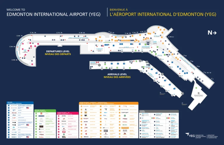
Aurora Airport Terminal Map
Location: Aurora, Oregon
Navigating Aurora Municipal Airport is a breeze with the most up-to-date Aurora Airport Terminal Map.
Aurora State Airport (UAO) in Aurora, Oregon, serves as a public-use airport located 1 mile northwest of Aurora. It operates under the management of the Oregon Department of Aviation and primarily supports general aviation, including flight training, charter services, and private aircraft operations. The airport features a single 5,004-foot asphalt runway.
Travelers can easily locate key features like the Skyway Café, renowned for its hearty breakfasts, and the full-service FBO offering pilot lounges and quick refueling. For those seeking convenience, ample parking is situated just steps from the terminal.
Whether you’re planning a flight or have already booked, this map ensures a seamless experience, highlighting every detail for a stress-free journey.
UAO Airport Terminal Overview Map 2024

FAQ
How big is the Aurora Airport?
Aurora State Airport spans approximately 144 acres and has a single asphalt runway measuring 5,004 feet in length and 100 feet in width.
What is the history of the Aurora State Airport?
Aurora State Airport was established in 1943 as a World War II training base for the U.S. Army Air Corps. After the war, it transitioned to civilian use and has since evolved into a hub for general aviation in Oregon, including flight training and private aviation.
Who owns Aurora Airport?
Aurora State Airport is owned and operated by the Oregon Department of Aviation.
Does Boeing own Aurora Flight Sciences?
Yes, Boeing owns Aurora Flight Sciences. The company, specializing in autonomous and unmanned aircraft systems, became a Boeing subsidiary after its acquisition in 2017.